Items Similar to Antique Map of the Cities of the Province of Shen-Si by Basire, 1738


Want more images or videos?
Request additional images or videos from the seller
1 of 5
Antique Map of the Cities of the Province of Shen-Si by Basire, 1738
$195.71
$244.6320% Off
£145.59
£181.9820% Off
€163.20
€20420% Off
CA$267.99
CA$334.9920% Off
A$297.97
A$372.4620% Off
CHF 155.58
CHF 194.4820% Off
MX$3,626.98
MX$4,533.7320% Off
NOK 1,985.16
NOK 2,481.4420% Off
SEK 1,860
SEK 2,324.9920% Off
DKK 1,242.35
DKK 1,552.9420% Off
Shipping
Retrieving quote...The 1stDibs Promise:
Authenticity Guarantee,
Money-Back Guarantee,
24-Hour Cancellation
About the Item
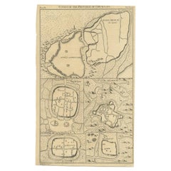
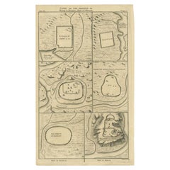
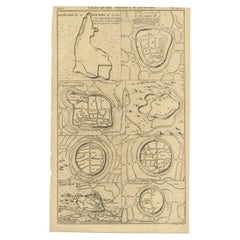
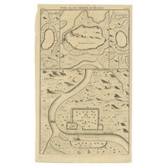
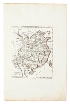
Antique print titled 'Cities of the Province of Shen-Si'. Old map depicting four walled cities of the Chinese Qing dynasty province of Shen-si (modern day SHAANXI): Si-ngan-fu, Chwang-lan, Lan-chew, Kan-chew, Ing-chew and Ku-ywen Chew. Originates from 'A description of the Empire of China and Chinese-Tartary' by J.B. du Halde. Du Halde's work inspired great interest in China among Europeans, and was a ground breaking work in geography. Artists and Engravers: Engraved by J. Basire. Published by E. Cave, London.
Artist: Engraved by J. Basire. Published by E. Cave, London.
Condition: Good, general age-related toning. Few marginal defects and worm holes (slightly affecting image), please study image carefully.
Date: 1738
Overall size: 24 x 39 cm.
Image size: 0.001 x 22 x 35 cm.
Antique prints have long been appreciated for both their aesthetic and investment value. They were the product of engraved, etched or lithographed plates. These plates were handmade out of wood or metal, which required an incredible level of skill, patience and craftsmanship. Whether you have a house with Victorian furniture or more contemporary decor an old engraving can enhance your living space. We offer a wide range of authentic antique prints for any budget.
- Dimensions:Height: 15.36 in (39 cm)Width: 9.45 in (24 cm)Depth: 0 in (0.01 mm)
- Materials and Techniques:
- Period:
- Date of Manufacture:1738
- Condition:
- Seller Location:Langweer, NL
- Reference Number:Seller: BGJC-1651stDibs: LU3054327773182
About the Seller
5.0
Recognized Seller
These prestigious sellers are industry leaders and represent the highest echelon for item quality and design.
Platinum Seller
Premium sellers with a 4.7+ rating and 24-hour response times
Established in 2009
1stDibs seller since 2017
2,510 sales on 1stDibs
Typical response time: <1 hour
- ShippingRetrieving quote...Shipping from: Langweer, Netherlands
- Return Policy
Authenticity Guarantee
In the unlikely event there’s an issue with an item’s authenticity, contact us within 1 year for a full refund. DetailsMoney-Back Guarantee
If your item is not as described, is damaged in transit, or does not arrive, contact us within 7 days for a full refund. Details24-Hour Cancellation
You have a 24-hour grace period in which to reconsider your purchase, with no questions asked.Vetted Professional Sellers
Our world-class sellers must adhere to strict standards for service and quality, maintaining the integrity of our listings.Price-Match Guarantee
If you find that a seller listed the same item for a lower price elsewhere, we’ll match it.Trusted Global Delivery
Our best-in-class carrier network provides specialized shipping options worldwide, including custom delivery.More From This Seller
View AllAntique Map of Cities of the Province of Che-Kyang in China, 1738
Located in Langweer, NL
Antique print China titled 'Cities of the Province of Che-Kyang'. Old map depicting four walled cities of the Chinese Qing dynasty province of Che-Kiang (modern day CHEKIANG): Hang C...
Category
Antique 18th Century Maps
Materials
Paper
$335 Sale Price
20% Off
Antique Map of the Cities of the Qing Dynasty Provinces in China, 1738
Located in Langweer, NL
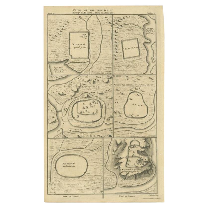
Antique print titled 'Cities of the Province of Kyang-si, Fo-kyen, Shan-Si & Yun-nan'. Old map depicting four walled cities of the Chinese Qing dynasty provinces Yunnan, Shanxi, Fuji...
Category
Antique 18th Century Maps
Materials
Paper
$249 Sale Price
20% Off
Antique Map of Cities of the Province of Shanxi in China, 1749
By Jacques-Nicolas Bellin
Located in Langweer, NL
Antique print titled: 'Lan-Tcheou ou Lan-Chew dan la province Chensi; Can Tcheou ou Kan-Chew dan la province de Chensi; Tchin-Ywe-Fou ou Chin-Ywen-Fu dans la province de Koei-Tcheou ...
Category
Antique 18th Century Maps
Materials
Paper

$239 Sale Price
20% Off
Antique Map of Cities of the Province of Che-Kiang in China, 1738
Located in Langweer, NL
Antique map titled 'Cities of the Province of Che-Kyang'. Old map depicting four walled cities of the Chinese Qing dynasty province of Che-Kiang (modern day CHEKIANG): Hang Chew Fu (...
Category
Antique 18th Century Maps
Materials
Paper
$335 Sale Price
20% Off
Antique Map of the Cities of the Province of Hu-Quang by Basire, 1738
Located in Langweer, NL
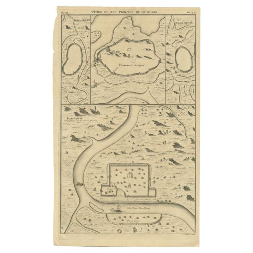
Antique print titled 'Cities of the Province of Hu-Quang'. Old map depicting four walled cities of the Chinese Qing dynasty province of Hu-Quang (modern day HUNAN and part of surroun...
Category
Antique 18th Century Maps
Materials
Paper
$195 Sale Price
20% Off
Antique Map of the Cities of the Province of Quey-Chew by Basire, 1738
Located in Langweer, NL
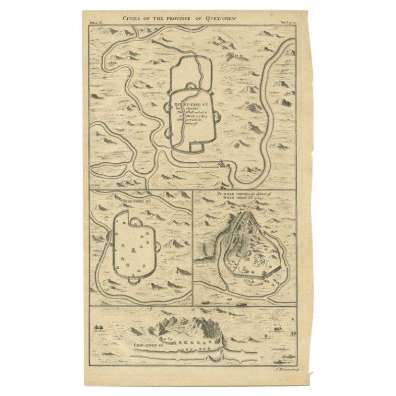
Antique print titled 'Cities of the Province of Quey-Chew'. Old map depicting four walled cities of the Chinese Qing dynasty province of Quey-Chew (modern day Guizhou) in S.W. China:...
Category
Antique 18th Century Maps
Materials
Paper

$195 Sale Price
20% Off
You May Also Like
17th-18th Century Siege of Graves Mapping Engraving By Willian III
Located in Kingston, NY
RARE French 17th-18th Century Enhanced Siege of Graves Mapping Engraving BY William III, also widely known as William of Orange,
The Siege of Grave in Dutch Brabant started by Monsie...
Category
Antique 17th Century French Prints
Materials
Paper

Original Antique Map of China, Arrowsmith, 1820
Located in St Annes, Lancashire
Great map of China
Drawn under the direction of Arrowsmith
Copper-plate engraving
Published by Longman, Hurst, Rees, Orme and Brown, 1820
Unfr...
Category
Antique 1820s English Maps
Materials
Paper

Map of China - Etching - 19th Century
Located in Roma, IT
This map of China is an etching realized in 19th century.
The state of preservation of the artwork is excellent. At the top of the paper, the inscription...
Category
19th Century Figurative Prints
Materials
Etching
1627 Hendrik Hondius Map Entitled "Vltoniae Orientalis Pars, " Ric.a009
Located in Norton, MA
1627 Hendrik Hondius map entitled
"Vltoniae orientalis pars,"
Ric.a009
Title:
Vltoniae orientalis : pars
Title (alt.) :
Ultoniae orientalis pars
Creator:
Mercator, Gerh...
Category
Antique 17th Century Dutch Maps
Materials
Paper

Super Rare Antique French Map of Chine and the Chinese Empire, 1780
Located in Amsterdam, Noord Holland
Super Rare Antique French Map of Chine and the Chinese Empire, 1780
Very nice map of Asia. 1780 Made by Bonne.
Additional information:
Type: Map
...
Category
Antique 18th Century European Maps
Materials
Paper

$584 Sale Price
33% Off
Southerlandia Map - Etching by Johannes Janssonius - 1650
By Johannes Janssonius
Located in Roma, IT
Southerlandia Map is an ancient map realized in 1650 by Johannes Janssonius (1588-1664).
The Map is Hand-colored etching, with coeval watercoloring.
Good conditions.
From Atlantis...
Category
1650s Modern Figurative Prints
Materials
Etching

More Ways To Browse
Chinese Etched Plate
Sardinia Map
Victorian Staircase
Nantucket Map
Afghanistan Antique Map
Antique Map Of Hawaii
Antique Florida Map
Map Of Syria
Napoleon Map
South Arabian
Antique Geological Maps
French School Map
Nova Scotia Antique Furniture
Richard Wentworth
Antique Mace
Map Of Madagascar
Map Of Normandy
Bali Map