Items Similar to Antique Map of the City of Groningen Made After Harrewijn, C.1750


Want more images or videos?
Request additional images or videos from the seller
1 of 5
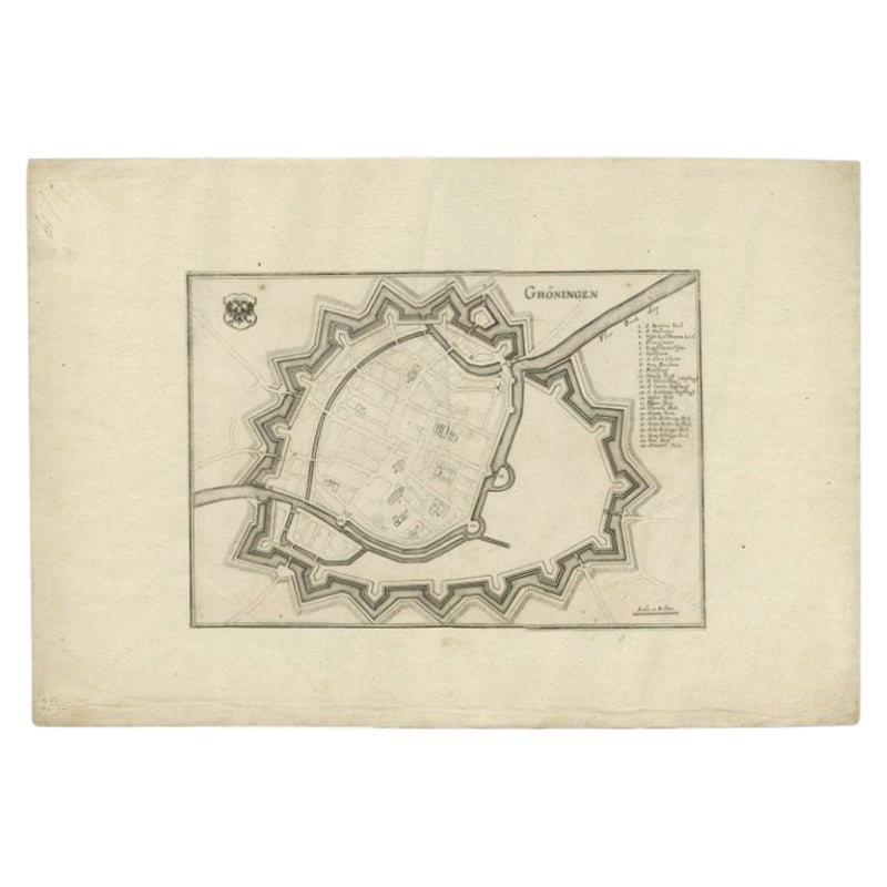
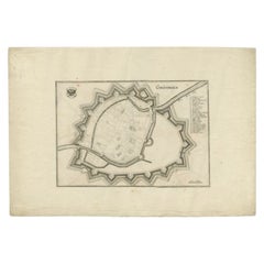
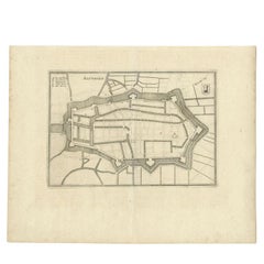
Antique Map of the City of Groningen Made After Harrewijn, C.1750
$105.40
$131.7520% Off
£78.11
£97.6420% Off
€88
€11020% Off
CA$143.89
CA$179.8720% Off
A$160.07
A$200.0920% Off
CHF 83.91
CHF 104.8920% Off
MX$1,956.07
MX$2,445.0920% Off
NOK 1,068.53
NOK 1,335.6620% Off
SEK 1,005.87
SEK 1,257.3420% Off
DKK 670.02
DKK 837.5320% Off
Shipping
Retrieving quote...The 1stDibs Promise:
Authenticity Guarantee,
Money-Back Guarantee,
24-Hour Cancellation
About the Item
Antique map titled 'Groeningue'. Old map of the city of Groningen, the Netherlands. Source unknown, to be determined.
Artists and Engravers: Most likely made after J. Harrewijn.
Condition: Good, general age-related toning. Bit 'blurry'. Please study image carefully.
Date: c.1750
Overall size: 22.5 x 17.5 cm.
Image size: 19 x 13.5 cm.
We sell original antique maps to collectors, historians, educators and interior decorators all over the world. Our collection includes a wide range of authentic antique maps from the 16th to the 20th centuries. Buying and collecting antique maps is a tradition that goes back hundreds of years. Antique maps have proved a richly rewarding investment over the past decade, thanks to a growing appreciation of their unique historical appeal. Today the decorative qualities of antique maps are widely recognized by interior designers who appreciate their beauty and design flexibility. Depending on the individual map, presentation, and context, a rare or antique map can be modern, traditional, abstract, figurative, serious or whimsical. We offer a wide range of authentic antique maps for any budget.
- Dimensions:Height: 6.89 in (17.5 cm)Width: 8.86 in (22.5 cm)Depth: 0 in (0.01 mm)
- Materials and Techniques:
- Period:
- Date of Manufacture:circa 1750
- Condition:
- Seller Location:Langweer, NL
- Reference Number:Seller: BG-028591stDibs: LU3054327792252
About the Seller
5.0
Recognized Seller
These prestigious sellers are industry leaders and represent the highest echelon for item quality and design.
Platinum Seller
Premium sellers with a 4.7+ rating and 24-hour response times
Established in 2009
1stDibs seller since 2017
2,494 sales on 1stDibs
Typical response time: 1 hour
- ShippingRetrieving quote...Shipping from: Langweer, Netherlands
- Return Policy
Authenticity Guarantee
In the unlikely event there’s an issue with an item’s authenticity, contact us within 1 year for a full refund. DetailsMoney-Back Guarantee
If your item is not as described, is damaged in transit, or does not arrive, contact us within 7 days for a full refund. Details24-Hour Cancellation
You have a 24-hour grace period in which to reconsider your purchase, with no questions asked.Vetted Professional Sellers
Our world-class sellers must adhere to strict standards for service and quality, maintaining the integrity of our listings.Price-Match Guarantee
If you find that a seller listed the same item for a lower price elsewhere, we’ll match it.Trusted Global Delivery
Our best-in-class carrier network provides specialized shipping options worldwide, including custom delivery.More From This Seller
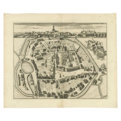
View AllAntique Map of the City of Groningen by Merian, 1659
Located in Langweer, NL
Antique map titled 'Gröningen'. This print depicts the city of Groningen, the Netherlands. This print originates from 'Topographia Germaniae Inferioris (..)' by C. Merian.
Artist...
Category
Antique 17th Century Maps
Materials
Paper
$88 Sale Price
20% Off
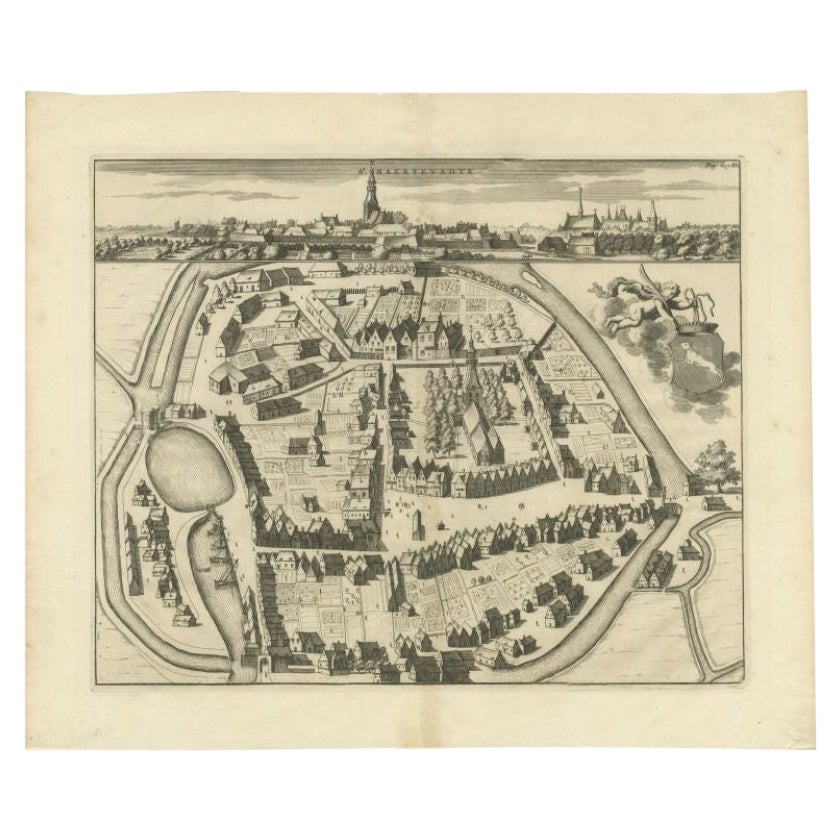
Antique Map of the City of Sint-Maartensdijk by Smallegange, c.1696
Located in Langweer, NL
Antique map titled 'St. Maertensdyk'. Original antique map of the city of Sint-Maartensdijk, the Netherlands. Source unknown, to be determined.
Artists and Engravers: Published b...
Category
Antique 17th Century Maps
Materials
Paper
$158 Sale Price
20% Off
Antique Map of the City of Geldern by Blaeu, 1649
Located in Langweer, NL
Antique map titled 'Gelre'. Old map of the city of Geldern, Germany. This map originates from 'Toonneel der Steden van de Vereenighde Nederlanden' by J. Blaeu.
Artists and Engrav...
Category
Antique 17th Century Maps
Materials
Paper

$380 Sale Price
20% Off
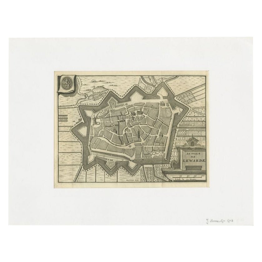
Antique Map of the City of Leeuwarden by Harrewijn, 1743
Located in Langweer, NL
Antique map titled 'La Ville de Lewarde'. Old map of the city of Leeuwarden, Friesland. Originates from 'Les Délices des Pays-Bas' by Widow Foppens.
Artists and Engravers: Engrav...
Category
Antique 18th Century Maps
Materials
Paper
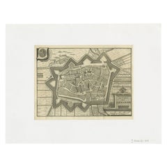
$117 Sale Price
20% Off
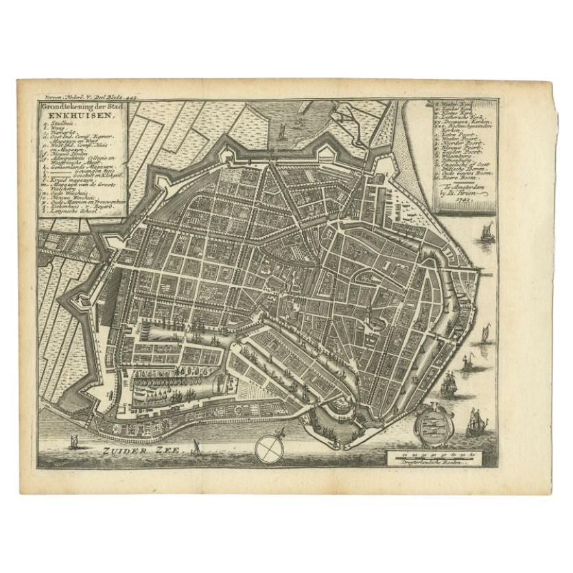
Antique Map of the City of Enkhuizen by Tirion, 1743
Located in Langweer, NL
Antique map titled ?Grondtekening der Stad Enkhuisen?. Beautiful map of the City of Enkhuizen. With Dutch legend. Decorated with compass rose, several ships and the city-arms. Artist...
Category
Antique 18th Century Maps
Materials
Paper
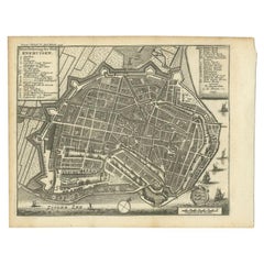
$143 Sale Price
20% Off
Antique Map of the City of Alkmaar by Merian, 1659
Located in Langweer, NL
Antique map titled 'Alckmaer'. This print depicts the city of Alkmaar (The Netherlands). This print originates from 'Topographia Germaniae Inferioris (..)' by C. Merian. Artists and ...
Category
Antique 17th Century Maps
Materials
Paper
$94 Sale Price
20% Off
You May Also Like
18th Century Map Engraving - Newport, a Strong Sea-Port Town in Flanders
Located in Corsham, GB
A map of Nieuwpoort, anglicised to 'Newport', in northern Belgium. There is a panorama in the upper quarter depicting major landmarks. Below is a plan of the town, including its strong defences and ships at the port in the lower register. Inscribed with the title in plate to the lower edge, 'Newport a Strong Sea-Port Town...
Category
18th Century More Prints
Materials
Engraving

$269 Sale Price
20% Off
Original Antique Map or City Plan of Amsterdam, Netherlands. Circa 1835
Located in St Annes, Lancashire
Nice map of Amsterdam
Drawn and engraved by J.Dower
Published by Orr & Smith. C.1835
Unframed.
Free shipping
Category
Antique 1830s English Maps
Materials
Paper

Utrecht, Antique Map from "Civitates Orbis Terrarum"
By Franz Hogenberg
Located in Roma, IT
Braun G., Hogenberg F., Traiectum or Utrecht, from the collection Civitates Orbis Terrarum, Cologne, T. Graminaeus, 1572-1617.
Very fine B/W aquatint showing a view of Utrecht, with...
Category
16th Century Landscape Prints
Materials
Etching

Large Original Antique Folding Map of Manchester, England, Dated 1793
Located in St Annes, Lancashire
Superb map of Manchester and Salford
Folding map. Printed on paper laid on to the original canvas
Unframed.
Published by C. Laurent, 1793.
Free shippi...
Category
Antique 1790s English Georgian Maps
Materials
Canvas, Paper

Map of Cambridge, engraving Pieter van der Aa after David Loggan
By Pieter Van Der Aa
Located in London, GB
Pieter van der Aa (1659 - 1733), after David Loggan (1634 - 1692)
Map of Cambridge
Engraving
12 x 16 cm
An eighteenth-century view of Cambridge, engraved by Pieter van der Aa after ...
Category
Early 18th Century Realist Prints and Multiples
Materials
Engraving

Utrecht, Netherlands: A Large 17th Century Hand-colored Map by Sanson & Jaillot
By Nicholas Sanson d'Abbeville
Located in Alamo, CA
This large hand-colored map entitled "La Seigneurie d'Utrecht. Dressé sur les memoires les plus nouveaux par le Sr. Sanson" was originally created by Nicholas Sanson d'Abbeville. Thi...
Category
1690s Landscape Prints
Materials
Engraving

More Ways To Browse
Antique Florida Map
Map Of Syria
Napoleon Map
South Arabian
Antique Geological Maps
French School Map
Nova Scotia Antique Furniture
Richard Wentworth
Antique Mace
Map Of Madagascar
Map Of Normandy
Bali Map
Croatia Map
Gibraltar Antique Map
Albania Antique Map
Antique Furniture Kingston
Antique Louisiana Map
Armenia Map