Items Similar to Antique Map of the Coast of Southwest Asia by Kitchin, c.1770


Want more images or videos?
Request additional images or videos from the seller
1 of 5
Antique Map of the Coast of Southwest Asia by Kitchin, c.1770
$108.31
$135.3920% Off
£80.63
£100.7920% Off
€90.40
€11320% Off
CA$148.36
CA$185.4520% Off
A$165.01
A$206.2620% Off
CHF 86.16
CHF 107.7020% Off
MX$2,007.99
MX$2,509.9920% Off
NOK 1,100.43
NOK 1,375.5420% Off
SEK 1,032.01
SEK 1,290.0120% Off
DKK 688.18
DKK 860.2320% Off
Shipping
Retrieving quote...The 1stDibs Promise:
Authenticity Guarantee,
Money-Back Guarantee,
24-Hour Cancellation
About the Item
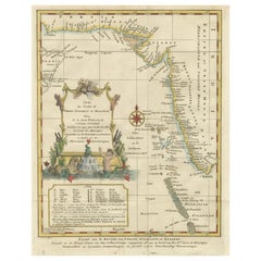
Antique map titled 'Chart of the Coast of Persia, Malabar & c'. Antique map of the coast of Southwest Asia. It shows the Maldives and part of Persia and India. Published for the 'London Magazine'.
Artists and Engravers: Thomas Kitchin (or Thomas Kitchen (1718 - 1784) was an English engraver and cartographer, who became hydrographer to the king. He was also an author, who wrote about the history of the West Indies.
Condition: Fair, age-related toning. Repair on large tear near 'Bombay'. Blank verso, please study image carefully.
Date: c.1770
Overall size: 20.5 x 25 cm.
Image size: 18 x 23 cm.
We sell original antique maps to collectors, historians, educators and interior decorators all over the world. Our collection includes a wide range of authentic antique maps from the 16th to the 20th centuries. Buying and collecting antique maps is a tradition that goes back hundreds of years. Antique maps have proved a richly rewarding investment over the past decade, thanks to a growing appreciation of their unique historical appeal. Today the decorative qualities of antique maps are widely recognized by interior designers who appreciate their beauty and design flexibility. Depending on the individual map, presentation, and context, a rare or antique map can be modern, traditional, abstract, figurative, serious or whimsical. We offer a wide range of authentic antique maps for any budget.
- Creator:Thomas Kitchin (Artist)
- Dimensions:Height: 9.85 in (25 cm)Width: 8.08 in (20.5 cm)Depth: 0 in (0.01 mm)
- Materials and Techniques:
- Period:
- Date of Manufacture:circa 1770
- Condition:Repaired: Repair on large tear near 'Bombay'. Condition: Fair, age-related toning. Repair on large tear near 'Bombay'. Blank verso, please study image carefully.
- Seller Location:Langweer, NL
- Reference Number:Seller: JAK-8771stDibs: LU3054327795502
About the Seller
5.0
Recognized Seller
These prestigious sellers are industry leaders and represent the highest echelon for item quality and design.
Platinum Seller
Premium sellers with a 4.7+ rating and 24-hour response times
Established in 2009
1stDibs seller since 2017
2,508 sales on 1stDibs
Typical response time: <1 hour
- ShippingRetrieving quote...Shipping from: Langweer, Netherlands
- Return Policy
Authenticity Guarantee
In the unlikely event there’s an issue with an item’s authenticity, contact us within 1 year for a full refund. DetailsMoney-Back Guarantee
If your item is not as described, is damaged in transit, or does not arrive, contact us within 7 days for a full refund. Details24-Hour Cancellation
You have a 24-hour grace period in which to reconsider your purchase, with no questions asked.Vetted Professional Sellers
Our world-class sellers must adhere to strict standards for service and quality, maintaining the integrity of our listings.Price-Match Guarantee
If you find that a seller listed the same item for a lower price elsewhere, we’ll match it.Trusted Global Delivery
Our best-in-class carrier network provides specialized shipping options worldwide, including custom delivery.More From This Seller
View AllAntique Map of the Arabian Peninsula by Bellin 'c.1740'
Located in Langweer, NL
Antique map titled 'Carte de la Coste d'Arabie, Mer Rouge et Golfe de Perse'. Original antique map of the Arabian Peninsula, labes both Mecca and Med...
Category
Antique Mid-18th Century Maps
Materials
Paper

$479 Sale Price
20% Off
Antique Map of the Coast of Guinea, Africa, c.1780
Located in Langweer, NL
Antique map Africa titled 'Carte de la Haute et de la Basse Guinée'. Map of the Coast of Guinea, Africa. Represents modern day Liberia, Ivory Coast, Ghana, Nigeria, Cameroon, Gabon, Congo, and Equatorial Guinea...
Category
Antique 18th Century Maps
Materials
Paper

$152 Sale Price
20% Off
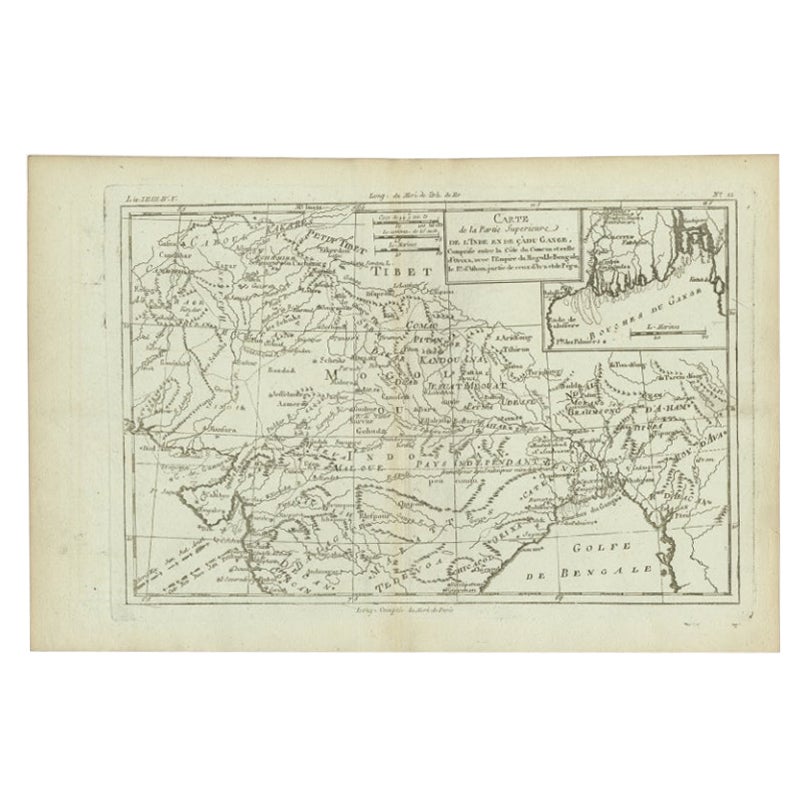
Antique Map of Part of Southern Asia by Bonne, c.1780
Located in Langweer, NL
Antique map titled 'Carte de la Partie Superieure de l'Inde en deca du Gange. Comprise entre la Cote du Concan et celle d'Orixa, avec l'Empire du Mogol, le Bengale, le R. d'Asham, pa...
Category
Antique 18th Century Maps
Materials
Paper
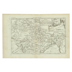
$119 Sale Price
20% Off
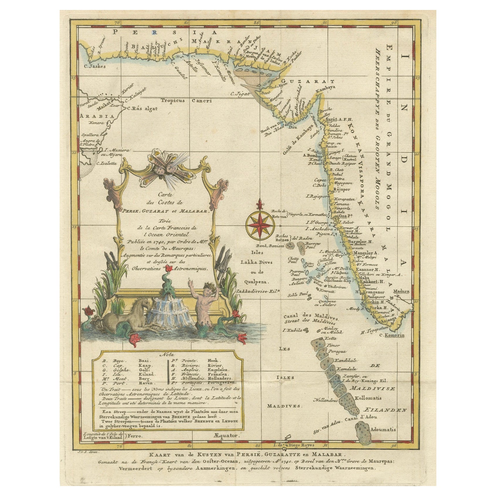
1773 Map of Persia, Gujarat & Malabar Coasts – Arabia to India, Hand-Colored
Located in Langweer, NL
1773 Bellin map of Persia, Gujarat and Malabar coasts with Arabia and Maldives
Description:
This finely engraved and delicately hand-colored 18th-century map titled Kaart van de Kusten van Persië, Guzaratte en Malabar was produced by the eminent French cartographer Jacques-Nicolas Bellin and engraved by Jakob van der Schley. It was published in 1773 in Amsterdam by E. van Harrevelt and D. Changuion, as part of a Dutch edition of Bellin’s maritime atlas focused on the East Indies and the Indian Ocean.
The map presents the coastline bordering the Arabian Sea, extending from the Persian Gulf and parts of the Arabian Peninsula to the shores of Gujarat and the Malabar Coast in southwestern India. It provides a detailed representation of the coastlines of Persia (modern-day Iran), the western coast of India, and a portion of southern Arabia including the Oman Peninsula. Coastal towns, rivers, ports, and geographical landmarks are clearly labeled, including prominent trading centers like Surat, Goa, Calicut, Cochin, and Cape Comorin (now Kanyakumari).
Additionally, the map shows the Laccadive Islands (Laka Dives) and the Maldives (Maldivische Eilanden), with attention to navigational details such as shoals, sandbanks, and anchor points. A large compass rose and clear latitude and longitude markings enhance its utility as a navigational aid.
A highly decorative title cartouche at lower left features maritime iconography such as sea creatures, a fountain, and shells. An inset legend beneath the map provides explanations in Dutch for the symbols used to indicate bays, capes, ports, forts, islands, and towns.
This is a copperplate engraving printed on laid paper with full original hand coloring. It retains its original fold lines as issued. The condition is generally good, with minor age toning and a few light spots in the margins. No repairs or restoration are visible. The paper is strong, and the impression remains crisp and clear.
This historical map is a significant and attractive example of 18th-century European cartography, especially valued for its depiction of maritime trade regions and coastal geography during the age of exploration and colonial expansion.
To frame this 1773 Bellin map attractively and safely:
- Use acid-free matting in a neutral tone like cream or antique white
- Consider double matting with a subtle inner color that complements the map
- Choose a simple wooden frame in walnut, cherry, or aged oak for a classic look
- Use UV-protective glass or acrylic to prevent fading
- For a full display, consider float mounting to show the edges and fold lines
- Allow 2 to 3 inch mat margins to balance the composition and enhance presentation
Keywords:
Bellin map 1773, van der Schley, Persia coast map, Gujarat map, Malabar map...
Category
Antique 1780s Maps
Materials
Paper
$325 Sale Price
20% Off
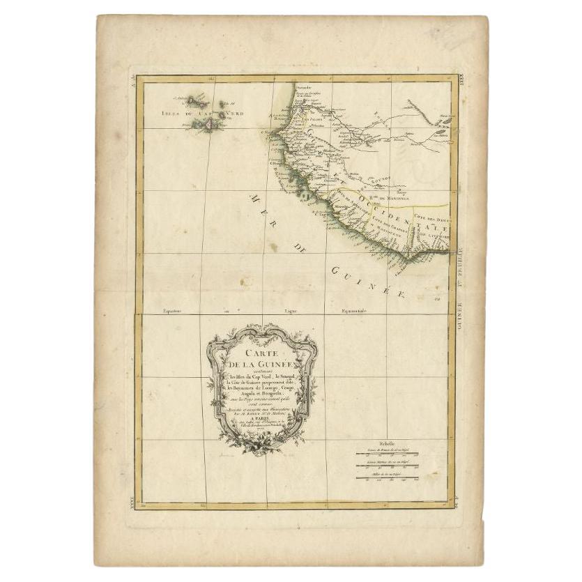
Antique Map of the West Coast of Africa, 1771
By Rigobert Bonne
Located in Langweer, NL
Antique map titled 'Carte de la Guinee contenant les Isles du Cap Verd, le Senegal, la Cote de Guinee proprement dite, les Royaumes de Loango, Congo, Angola, et Benguela avec les Pay...
Category
Antique 18th Century Maps
Materials
Paper

$335 Sale Price
20% Off
Antique Map of the Gulf of Bengal by J.N. Bellin, circa 1760
Located in Langweer, NL
Beautiful chart of the Gulf of Bengal. The map extends from Malabar to Sumatra and today Phuket area in Thailand. Including Pegu, Ceylon, and the Andaman and Nicobar Islands. Numerou...
Category
Antique Mid-18th Century Maps
Materials
Paper

$330 Sale Price
20% Off
You May Also Like
West Coast of Africa, Guinea & Sierra Leone: An 18th Century Map by Bellin
By Jacques-Nicolas Bellin
Located in Alamo, CA
Jacques Bellin's copper-plate map entitled "Partie de la Coste de Guinee Dupuis la Riviere de Sierra Leona Jusquau Cap das Palmas", depicting the coast of Guinea and Sierra Leone in ...
Category
Antique Mid-18th Century French Maps
Materials
Paper

Antique French Map of Asia Including China Indoneseia India, 1783
Located in Amsterdam, Noord Holland
Very nice map of Asia. 1783 Dedie au Roy.
Additional information:
Country of Manufacturing: Europe
Period: 18th century Qing (1661 - 1912)
Condition: Overall Condition B (Good Used)...
Category
Antique 18th Century European Maps
Materials
Paper

$648 Sale Price
20% Off
Original Antique Map of South America. C.1780
Located in St Annes, Lancashire
Great map of South America
Copper-plate engraving
Published C.1780
Two small worm holes to left side of map
Unframed.
Category
Antique Early 1800s English Georgian Maps
Materials
Paper

Map of Nubia and Abissinia - Original Etching by Antonio Zatta - 1784
Located in Roma, IT
This Map of Nubia and Abissinia is an etching realized by Antonio Zatta in Venice in 1784.
The state of preservation of the artwork is good expect for the worn paper with some littl...
Category
1770s Landscape Prints
Materials
Etching

West Africa Entitled "Guinea Propria": An 18th Century Hand Colored Homann Map
By Johann Baptist Homann
Located in Alamo, CA
This is a scarce richly hand colored copper plate engraved map of Africa entitled "Guinea Propria, nec non Nigritiae vel Terrae Nigrorum Maxima Pars" by Johann Baptist Homann (1664-1...
Category
Antique Mid-18th Century German Maps
Materials
Paper

California, Alaska and Mexico: 18th Century Hand-Colored Map by de Vaugondy
By Didier Robert de Vaugondy
Located in Alamo, CA
This is an 18th century hand-colored map of the western portions of North America entitled "Carte de la Californie et des Pays Nord-Ouest separés de l'Asie par le détroit d'Anian, ex...
Category
Antique 1770s French Maps
Materials
Paper

More Ways To Browse
Antique Kitchen Collectibles
Thomas Toner
Malabar X
Map Of Normandy
Bali Map
Croatia Map
Gibraltar Antique Map
Albania Antique Map
Antique Furniture Kingston
Antique Louisiana Map
Armenia Map
L Tardieu
Chinese Wall Pocket
18th Century Nautical Engraving
Antique Map Burgundy
Antique Map By Coronelli
Antique Maps Singapore
Constantinople Map