Items Similar to Antique Map of Continental Asia, with Japan, Arabia, India, Russia, etc c.1702


Want more images or videos?
Request additional images or videos from the seller
1 of 6
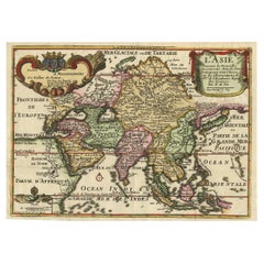
Antique Map of Continental Asia, with Japan, Arabia, India, Russia, etc c.1702
$1,616.49
£1,194.94
€1,350
CA$2,198.53
A$2,463.44
CHF 1,282.32
MX$30,136.44
NOK 16,276.63
SEK 15,373.08
DKK 10,279.59
Shipping
Retrieving quote...The 1stDibs Promise:
Authenticity Guarantee,
Money-Back Guarantee,
24-Hour Cancellation
About the Item
Antique map titled 'Totius Asiae Continens (..).' On this map of continental Asia and the adjacent islands Japan is shown with an oversized Terra Iedso (Hokkaido) connected with Honshu via a narrow isthmus. The Compagnie Land of the de Vries expedition is shown above, separated by a narrow strait named after the explorer. Nova Zembla is depicted correctly as an island, but the northeastern part of Siberia, the Chukchi peninsula and Kamchatka are missing. A portion of Australia is shown as Nova Hollandia with New Guinea shown separate from Terra des Papous. The title is surrounded with a beautifully engraved cartouche, and the scale of miles is topped by the symbol for the Society of Jesus.
Source unknown, to be determined.
Artists and Engravers: Heinrich Scherer (1628-1704) was a Professor of Hebrew, Mathematics and Ethics at the University of Dillingen until about 1680. Thereafter he obtained important positions as Official Tutor to the Royal Princes of Mantua and Bavaria. It was during his time in Munich as Tutor to the Princely house of Bavaria that his lifetime’s work as a cartographer received acclaim and recognition. Scherer’s world atlas, the Atlas Novus, first published in Munich between 1702 and 1710 and reissued in a second edition between 1730 and 1737, forms a singularly unusual, almost revolutionary work in terms of the development of European mapmaking at the beginning of the 18th Century.
Condition: Very good, given age. Original folds as issued. General age-related toning and/or occasional minor defects from handling. Please study image carefully.
Date: 1702
Overall size: 40.5 x 27.3 cm.
Image size: 35.2 x 23 cm.
We sell original antique maps to collectors, historians, educators and interior decorators all over the world. Our collection includes a wide range of authentic antique maps from the 16th to the 20th centuries. Buying and collecting antique maps is a tradition that goes back hundreds of years. Antique maps have proved a richly rewarding investment over the past decade, thanks to a growing appreciation of their unique historical appeal. Today the decorative qualities of antique maps are widely recognized by interior designers who appreciate their beauty and design flexibility. Depending on the individual map, presentation, and context, a rare or antique map can be modern, traditional, abstract, figurative, serious or whimsical. We offer a wide range of authentic antique maps for any budget.
- Dimensions:Height: 10.75 in (27.3 cm)Width: 15.95 in (40.5 cm)Depth: 0 in (0.01 mm)
- Materials and Techniques:
- Period:
- Date of Manufacture:1702
- Condition:Condition: Very good, given age. Original folds as issued. General age-related toning and/or occasional minor defects from handling. Please study image carefully.
- Seller Location:Langweer, NL
- Reference Number:Seller: PCT-592041stDibs: LU3054326145842
About the Seller
5.0
Recognized Seller
These prestigious sellers are industry leaders and represent the highest echelon for item quality and design.
Platinum Seller
Premium sellers with a 4.7+ rating and 24-hour response times
Established in 2009
1stDibs seller since 2017
2,494 sales on 1stDibs
Typical response time: 1 hour
- ShippingRetrieving quote...Shipping from: Langweer, Netherlands
- Return Policy
Authenticity Guarantee
In the unlikely event there’s an issue with an item’s authenticity, contact us within 1 year for a full refund. DetailsMoney-Back Guarantee
If your item is not as described, is damaged in transit, or does not arrive, contact us within 7 days for a full refund. Details24-Hour Cancellation
You have a 24-hour grace period in which to reconsider your purchase, with no questions asked.Vetted Professional Sellers
Our world-class sellers must adhere to strict standards for service and quality, maintaining the integrity of our listings.Price-Match Guarantee
If you find that a seller listed the same item for a lower price elsewhere, we’ll match it.Trusted Global Delivery
Our best-in-class carrier network provides specialized shipping options worldwide, including custom delivery.More From This Seller
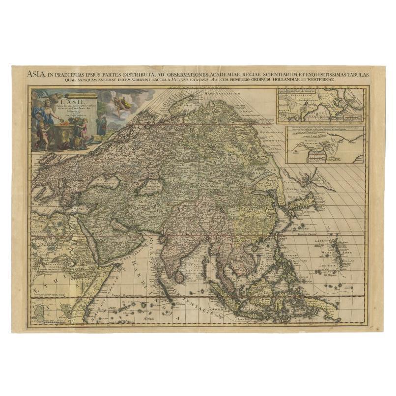
View AllAntique Map of Asia by Tirion 'c.1760'
Located in Langweer, NL
Antique map titled 'Nuova Carta dell Asia'. Decorative map of Asia. Published by I. Tirion, circa 1760.
Category
Antique Mid-18th Century Maps
Materials
Paper

$1,053 Sale Price
20% Off
Important and Scarce Antique Map of Asia from Jesuit Sources, C.1713
Located in Langweer, NL
Antique map titled 'L'Asie selon les nouvelles observations de Messrs de l'Academie des Sciences etc'. The main focus of this important and scarce map of Asia is the delineation of the northeast part of the continent from Jesuit sources. The northeast coast is severely truncated with the discoveries of Nicolas Witsen shown, and the partial coastlines of Jesso and Compagnies Land are depicted to the north of Japan. Inset in the North Pacific is a map of that same region based on the information from Father Martino Martini. It shows Jesso connected to the mainland with a narrow strait between it and a huge Compagnies Land. An inset below, taken from Father Ferdinand Verbiest, illustrates the road between Peking and Kirin and Nincrita. Father Verbiest's world map of 1674, which he compiled for the Chinese, subsequently led to the Jesuits obtaining a commission to make a comprehensive topographical...
Category
Antique 18th Century Maps
Materials
Paper

$3,352 Sale Price
20% Off
Antique Map of North and East Asia, 1751
Located in Langweer, NL
Map 2: 'Carte des parties nord et est de L'Asie'. (Map of the Northern parts and East Asia.) Five maps on one sheet, showing California, Alaska and Siberia, Korea and Japan. South to...
Category
Antique 18th Century Maps
Materials
Paper

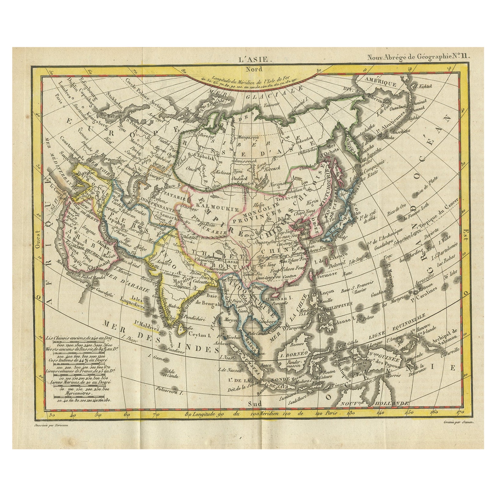
Antique Map of Asia from the Middle East to the Coast of Alaska, 1816
Located in Langweer, NL
Antique map titled ‘L’Asie‘. This is an original antique map of Asia, by Hérisson, taken from atlas ""Nouv. Abrége de Géographie"". An engraved map with coloring of Asia from the Mid...
Category
Antique 19th Century Maps
Materials
Paper
$153 Sale Price
20% Off
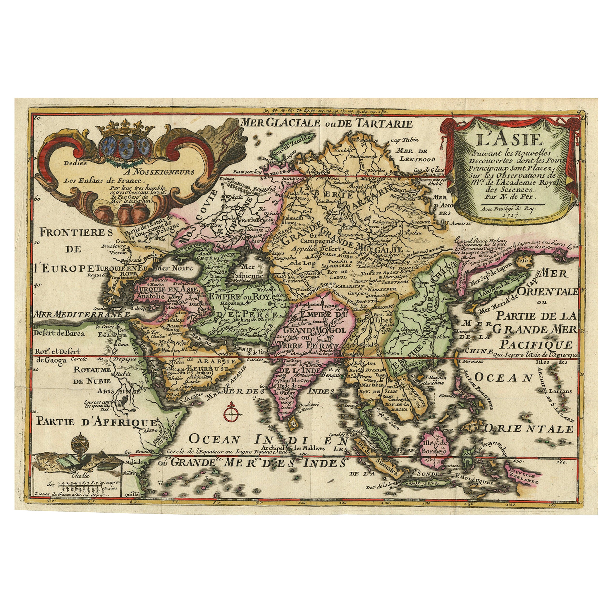
Rare Unusual Antique Map of Asia with a Landbridge from Korea to America, 1717
Located in Langweer, NL
Antique map titled 'L'Asie Suivant les Nouvelles Decouvertes (..).' Interesting and very unusual map of the Asian continent.
The map is based primarily on Dutch sources, particular...
Category
Antique 18th Century Maps
Materials
Paper
Antique Map of Asia by Pierre du Val, '1663'
Located in Langweer, NL
Antique map titled 'L'Asie'. Antique map of the Asian continent by Pierre Duval, dated 1663. Most place names represent geographical entities that currently exist or once existed. The rendition of the lower islands of Japan and the peninsula of Korea are improved over earlier studies. Details of the Great Wall of China...
Category
Antique Mid-17th Century Maps
Materials
Paper
$1,724 Sale Price
20% Off
You May Also Like
Antique French Map of Asia Including China Indoneseia India, 1783
Located in Amsterdam, Noord Holland
Very nice map of Asia. 1783 Dedie au Roy.
Additional information:
Country of Manufacturing: Europe
Period: 18th century Qing (1661 - 1912)
Condition: Overall Condition B (Good Used)...
Category
Antique 18th Century European Maps
Materials
Paper

$648 Sale Price
20% Off
Antique 1803 Italian Map of Asia Including China Indoneseia India
Located in Amsterdam, Noord Holland
Antique 1803 Italian Map of Asia Including China Indoneseia India
Very nice map of Asia. 1803.
Additional information:
Type: Map
Country of Manufacturing: Europe
Period: 19th centu...
Category
Antique 19th Century European Maps
Materials
Paper

$584 Sale Price
20% Off
Super Rare Antique French Map of Chine and the Chinese Empire, 1780
Located in Amsterdam, Noord Holland
Super Rare Antique French Map of Chine and the Chinese Empire, 1780
Very nice map of Asia. 1780 Made by Bonne.
Additional information:
Type: Map
...
Category
Antique 18th Century European Maps
Materials
Paper

$584 Sale Price
33% Off
1627 Hendrik Hondius Map Entitled "Vltoniae Orientalis Pars, " Ric.a009
Located in Norton, MA
1627 Hendrik Hondius map entitled
"Vltoniae orientalis pars,"
Ric.a009
Title:
Vltoniae orientalis : pars
Title (alt.) :
Ultoniae orientalis pars
Creator:
Mercator, Gerh...
Category
Antique 17th Century Dutch Maps
Materials
Paper

1718 Ides & Witsen Map "Route D'amsterdam a Moscow Et De La Ispahan Et Gamron
Located in Norton, MA
1718 Ides & Witsen map, entitled
"Route D'Amsterdam A Moscow Et De La Ispahan Et Gamron,"
Ric.b005
Subject: Eastern Europe and Central Asia
Period: 1718 (published)
Publicati...
Category
Antique Early 18th Century Dutch Maps
Materials
Paper

1633 Map "La Souverainete De Sedan Et De Raucourt, Et La Prevoste Ric0011
Located in Norton, MA
1653 map entitled
"La Souverainete de Sedan et de Raucourt, et la Prevoste de Doncheri,"
Ric0011
Description:
Lovely map centered on Sedan and Doncheri and the Meuze River fr...
Category
Antique 17th Century Dutch Maps
Materials
Paper

More Ways To Browse
Royal Prince
Japan Antiques Collectables
Heinrich Bavaria
Nova Hollandia
Joan Blaeu
Antique Nautical Maps
Antique Portuguese Plates
New Zealand Map
Antique Railroad Collectibles
Blaeu World Map
Roman Empire Map
Antique Map Of Middle East
Caribbean Map
Antique Map Of Egypt
Antique Map Ortelius
Antique Farm Antiques Collectibles
Antique Galleon
Biblical Maps