Items Similar to Antique Map Covering Northern Italy, Austria, Slovenia & Croatia, ca.1690
Want more images or videos?
Request additional images or videos from the seller
1 of 6
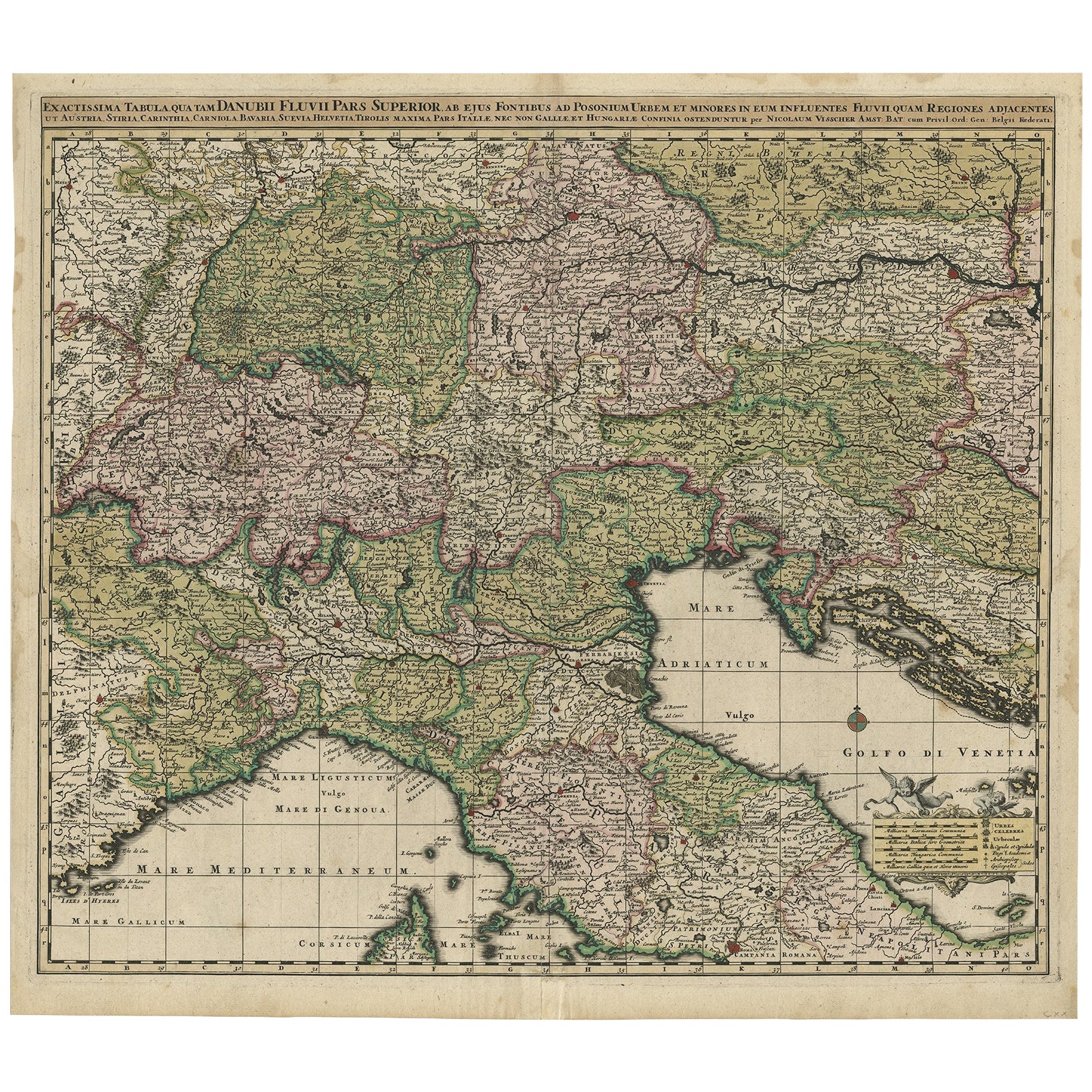
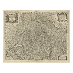
Antique Map Covering Northern Italy, Austria, Slovenia & Croatia, ca.1690
$803.39
$1,004.2320% Off
£602.19
£752.7420% Off
€680
€85020% Off
CA$1,103.72
CA$1,379.6520% Off
A$1,232.20
A$1,540.2520% Off
CHF 645.65
CHF 807.0720% Off
MX$15,083.31
MX$18,854.1320% Off
NOK 8,199.80
NOK 10,249.7520% Off
SEK 7,731.37
SEK 9,664.2120% Off
DKK 5,176.41
DKK 6,470.5120% Off
Shipping
Retrieving quote...The 1stDibs Promise:
Authenticity Guarantee,
Money-Back Guarantee,
24-Hour Cancellation
About the Item
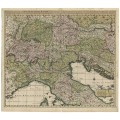
Antique map titled 'Exactissima Tabula, qua tam Danubii Fluvii Pars Superior'.
Detailed map covering the region of northern Italy, Austria, Slovenia and Croatia. The course of the Danube is prominently shown from its headwaters in the Alps to its confluence with the Morava River.
Artists and Engravers: Nicolaes Visscher II (1649, Amsterdam – 1702, Amsterdam) was a Dutch engraver, cartographer and publisher. He was the son of Nicolaes Visscher I and the grandson of Claes Janszoon Visscher. After his death, his wife, Elisabeth, continued the family tradition of mapmaking and publishing. The works, engraved plates, were then sold to Peter Schenk, who also reprinted them.
Condition: Good, general age-related toning. Please study image carefully.
- Dimensions:Height: 21.07 in (53.5 cm)Width: 25.2 in (64 cm)Depth: 0 in (0.02 mm)
- Materials and Techniques:
- Period:1690-1699
- Date of Manufacture:circa 1690
- Condition:
- Seller Location:Langweer, NL
- Reference Number:Seller: BG-09190 1stDibs: LU3054326767912
About the Seller
5.0
Recognized Seller
These prestigious sellers are industry leaders and represent the highest echelon for item quality and design.
Platinum Seller
Premium sellers with a 4.7+ rating and 24-hour response times
Established in 2009
1stDibs seller since 2017
2,511 sales on 1stDibs
Typical response time: <1 hour
- ShippingRetrieving quote...Shipping from: Langweer, Netherlands
- Return Policy
Authenticity Guarantee
In the unlikely event there’s an issue with an item’s authenticity, contact us within 1 year for a full refund. DetailsMoney-Back Guarantee
If your item is not as described, is damaged in transit, or does not arrive, contact us within 7 days for a full refund. Details24-Hour Cancellation
You have a 24-hour grace period in which to reconsider your purchase, with no questions asked.Vetted Professional Sellers
Our world-class sellers must adhere to strict standards for service and quality, maintaining the integrity of our listings.Price-Match Guarantee
If you find that a seller listed the same item for a lower price elsewhere, we’ll match it.Trusted Global Delivery
Our best-in-class carrier network provides specialized shipping options worldwide, including custom delivery.More From This Seller
View AllFinely Detailed Map Covering Northern Italy, Austria, Slovenia & Croatia, c.1690
Located in Langweer, NL
Antique map titled 'Exactissima Tabula, qua tam Danubii Fluvii Pars Superior'.
Very finely detailed map covering the region of northern Italy, Austria, Slovenia and Croatia. The co...
Category
Antique 1690s Maps
Materials
Paper
$1,748 Sale Price
20% Off
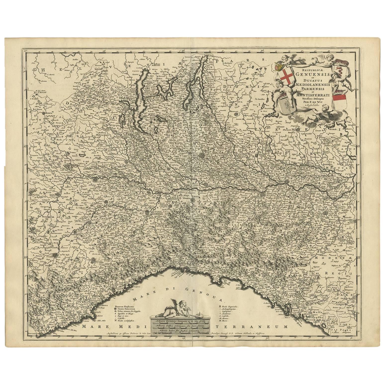
Antique Map of Northern Italy by F. de Wit, 1690
Located in Langweer, NL
A very decorative map centered on Genua, and including the towns of Milan, Torino, Parma, Cremona, etc. Decorative title cartouche upper right, five putti holding the arms of the reg...
Category
Antique Late 17th Century Maps
Materials
Paper

$519 Sale Price
20% Off
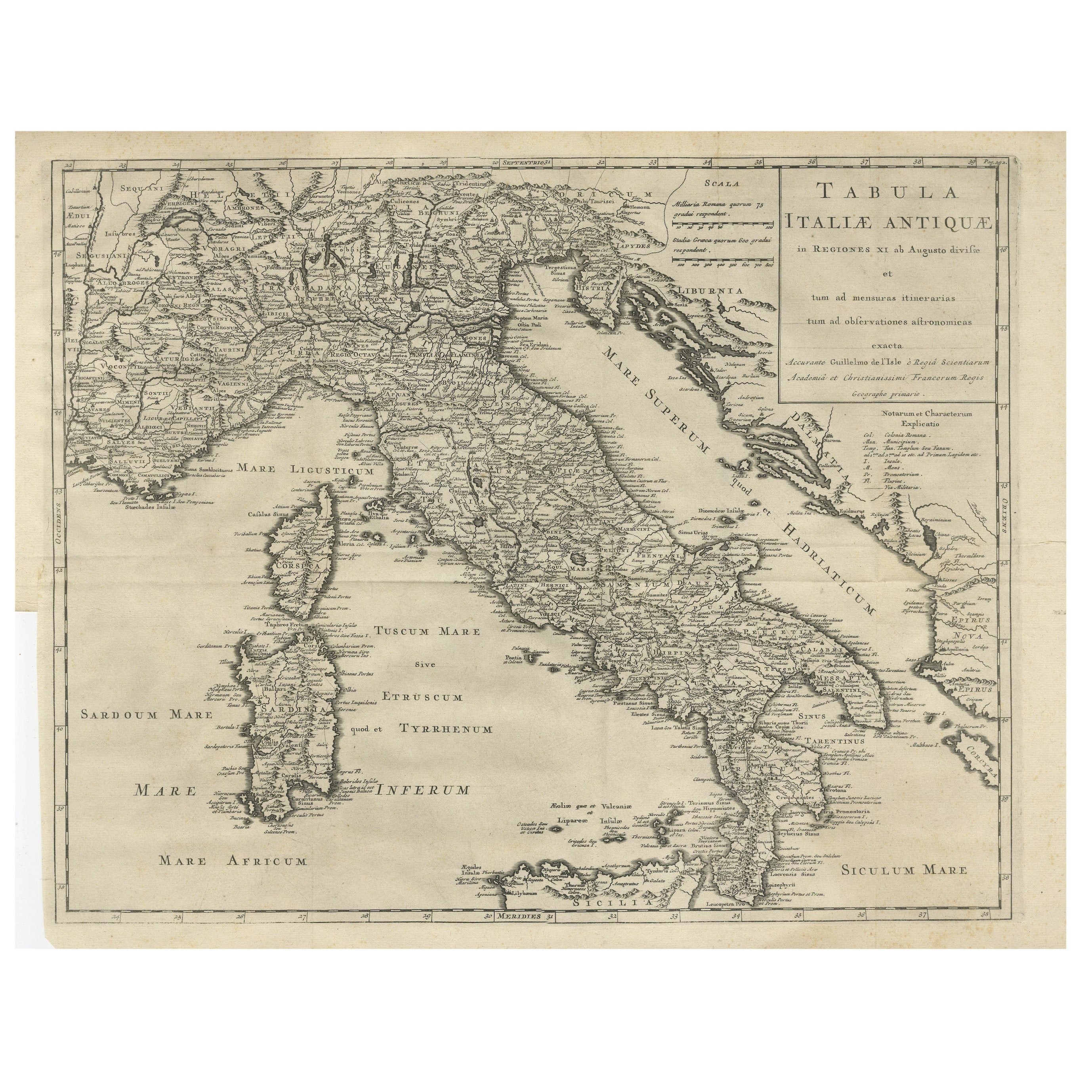
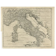
Antique Engraved Map of Italy in Roman Times, ca.1730
Located in Langweer, NL
Plain engr. map of Italy according to the division of Emperor Augustus by G. Delisle.
Title: "Tabula Italiae Antiquae In Regiones XI Ab Augusto Divisae Et Tum Ad Mensuras Itinerari...
Category
Antique 1730s Maps
Materials
Paper
$642 Sale Price
20% Off
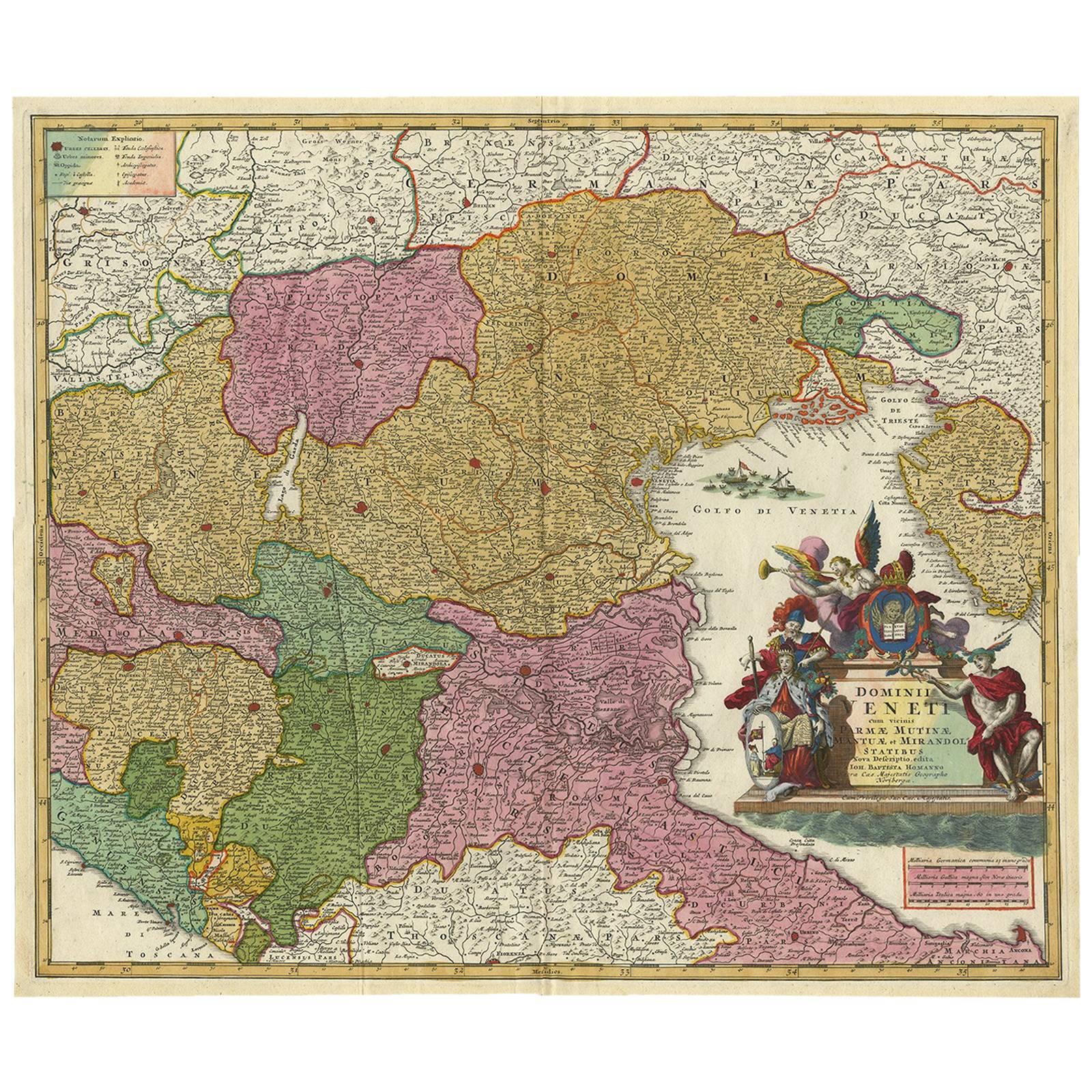
Stunning Antique Map of Northern Italy by J.B. Homann, circa 1745
By Johann Baptist Homann
Located in Langweer, NL
This beautiful hand-colored map covers from Bergamo east as far as Albona (Labin) and from Vipiteno Sterzing south as far as Florence.
The map is exceptionally detailed, noting towns, rivers, lakes, cities and a host of additional topographical features. Includes neighboring Parma, Modena, Mantua and Mirandol. The map depicts the Veneto region and its vicinity during the decline of the Republic of Venice. A key in included in the top left quadrant of the map, while a beautifully engraved title cartouche adorns the lower right quadrant. This map was issued in Homann Heirs circa 1745 edition of Atlas Novus Terrarum Orbis.
Category
Antique Mid-18th Century Maps
Materials
Paper

$624 Sale Price
25% Off
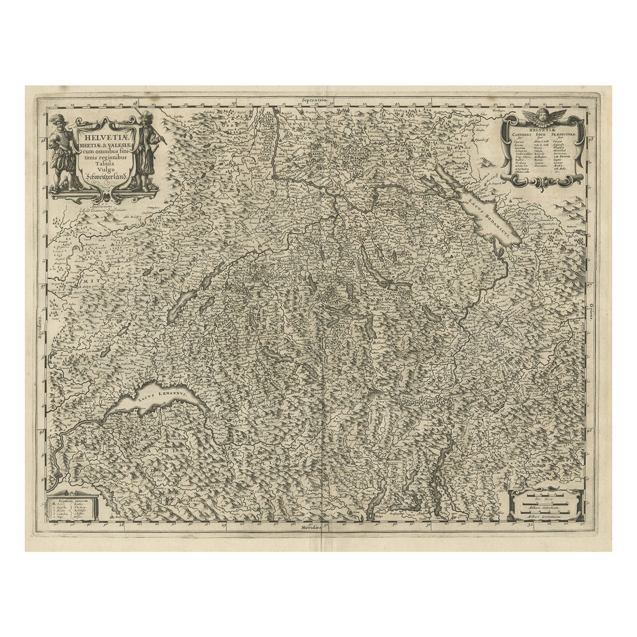
Decorative and Detailed Original Antique Map of Switzerland, 1657
Located in Langweer, NL
Antique map of Switzerland titled 'Helvetiae Rhetiae & Valesiae'.
Decorative and detailed map of Switzerland. This map originates from 'Atlas Novus, Sive Theatrum Orbis Orbis Ter...
Category
Antique 1650s Maps
Materials
Paper
$812 Sale Price
20% Off
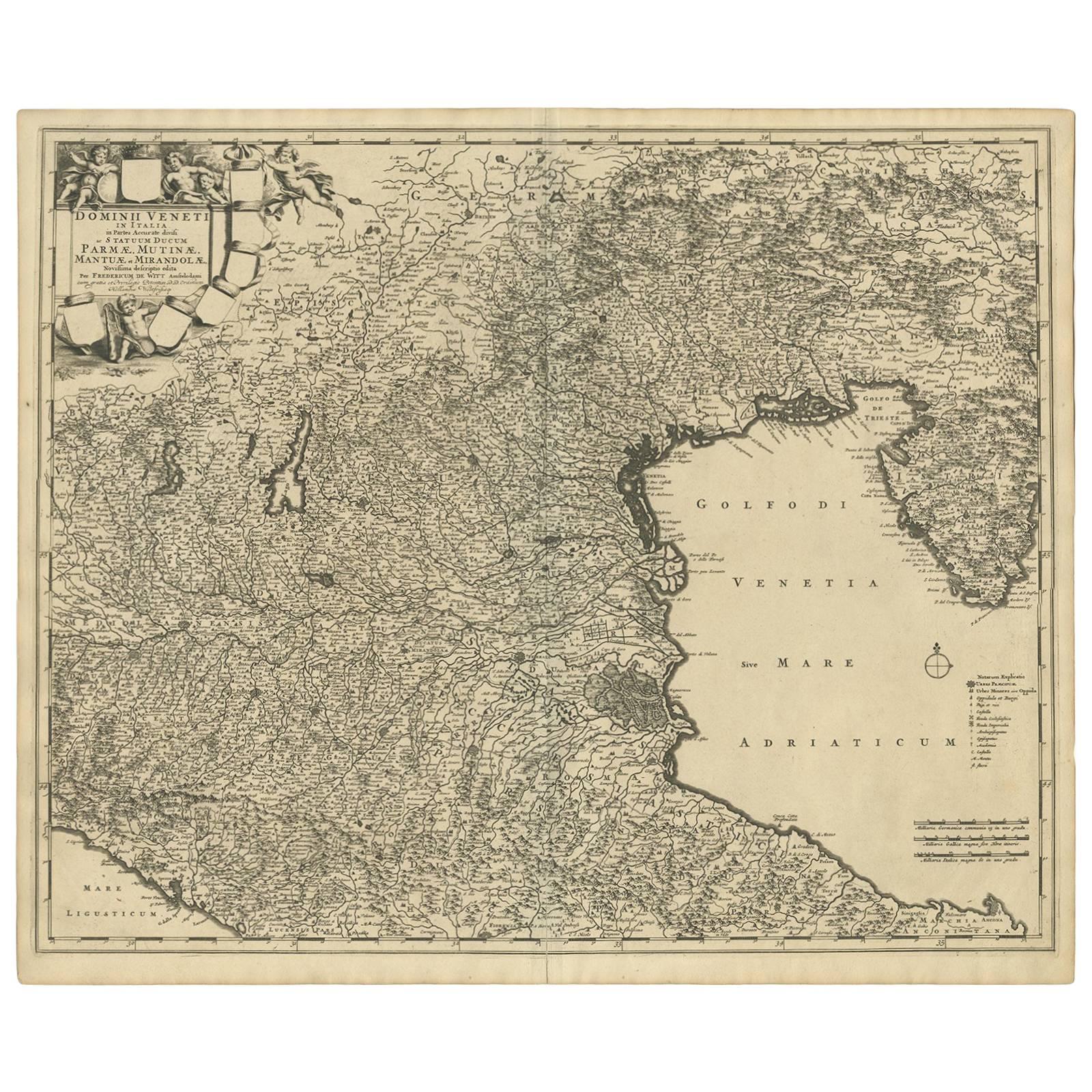
Antique Map of the Region of Venice, Italy by F. De Wit, circa 1700
Located in Langweer, NL
Antique map of the Dominion of Venice, extending from Stato di Milano and Genoa to Istria. Including Lake Garda, Venice and Istria.
Category
Antique Early 18th Century Maps
Materials
Paper
$557 Sale Price
20% Off
You May Also Like
17th Century Nicolas Visscher Map of Southeastern Europe
Located in Hamilton, Ontario
A beautiful, highly detailed map of southeastern Europe by Nicolas Visscher. Includes regions of Northern Italy (showing the cities Bologna, Padua, and Venice), Bohemia, Austria (sho...
Category
Antique 17th Century Dutch Maps
Materials
Paper

$1,350 Sale Price
38% Off
Original Antique Map of Switzerland, Engraved By Barlow, Dated 1807
Located in St Annes, Lancashire
Great map of Switzerland
Copper-plate engraving by Barlow
Published by Brightly & Kinnersly, Bungay, Suffolk.
Dated 1807
Unframed.
Category
Antique Early 1800s English Maps
Materials
Paper

Large Original Antique Map of Italy. John Dower, 1861
Located in St Annes, Lancashire
Great map of Italy
Lithograph engraving by John Dower
Original colour
Published, 1861
Unframed
Good condition / repair to top right corner seen in last image
Category
Antique 1860s English Victorian Maps
Materials
Paper

Southern & Eastern Europe: A Large 17th C. Hand-colored Map by Sanson & Jaillot
By Nicolas Sanson
Located in Alamo, CA
This large hand-colored map entitled "Estats de L'Empire des Turqs en Europe, ou sont les Beglerbeglicz our Gouvernements" was originally created by Nicholas Sanson d'Abbeville and t...
Category
Antique 1690s French Maps
Materials
Paper

Original Antique Map of Europe, Arrowsmith, 1820
Located in St Annes, Lancashire
Great map of Europe
Drawn under the direction of Arrowsmith.
Copper-plate engraving.
Published by Longman, Hurst, Rees, Orme and Brown, 1820
...
Category
Antique 1820s English Maps
Materials
Paper

18th Century Map of the Southern Balkans by Giovanni Maria Cassini
By Giovanni Maria Cassini
Located in Hamilton, Ontario
18th century map by Italian engraver Giovanni Maria Cassini (Italy 1745-1824).
Map of the Southern Balkans: Rome. Hand colored and copper engraved print done in the year 1788. It in...
Category
Antique 18th Century Italian Maps
Materials
Paper

$795 Sale Price
36% Off
More Ways To Browse
Croatian Artist
Austrian Alps
Croatian Antiques
Croatia Map
Antique Navigational Tools
Antique German Compass
Key Trade Sign
Spanish Galleon
World Map Of Trade Routes
Antique Puerto Rico
Albanian Antique
Antique Furniture Wiltshire
Antique Maps Of Israel
Framed Africa Maps
Antique Furniture Goa
Croatian Antiques
Map Of Israel
Teak Sphere