
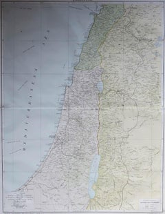
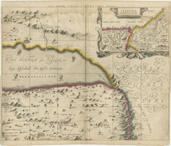
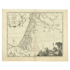
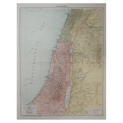
Large Original Vintage Map of Israel, circa 1920
Located in St Annes, Lancashire
Great map of Israel Original color. Good condition Published by Alexander Gross Unframed.
Category
Vintage 1920s English Edwardian Maps
Materials
Paper
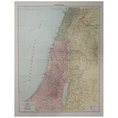
Large Original Vintage Map of Israel, circa 1920
Located in St Annes, Lancashire
Great map of Israel Original color. Good condition Published by Alexander Gross Unframed.
Paper
$923
H 14.18 in W 19.3 in D 0 in
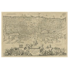
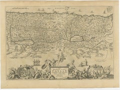
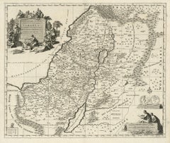
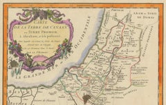
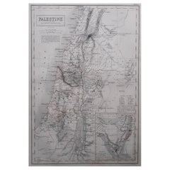
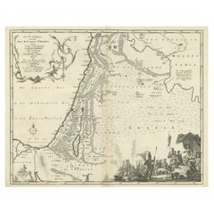
Promised Land of Canaan – Antique Map of Israel with Biblical Scenes, van Jagen
Located in Langweer, NL
Promised Land of Canaan – Antique Map of Israel with Biblical Scenes, van Jagen This remarkable antique map titled Het beloofde landt Canaan doorwandelt van onsen Saligmaker Jesu Ch...
Paper
$233Sale Price|20% Off
H 14.97 in W 12.41 in D 0.02 in
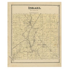
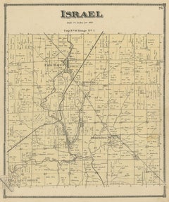
Antique Map of the Israel Township of Ohio by Titus '1871'
Located in Langweer, NL
Antique map titled 'Israel'. Original antique map of Israel, Ohio.
Paper
$1,287
H 21.46 in W 28.55 in D 0.01 in
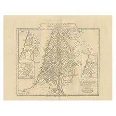
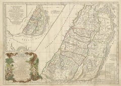
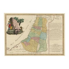
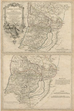
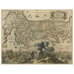
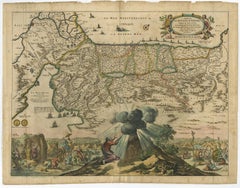
Antique Map of Biblical Palestine – Holy Land & Jerusalem Insets, c.1818
Located in Langweer, NL
Particularly striking when framed as part of a classical or biblical map grouping. Technique: Engraving with original outline color Maker: Jean-Baptiste Bourguignon d’Anville (after...
Paper
$1,928
H 20.79 in W 24.81 in D 0.01 in
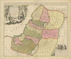
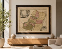
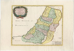
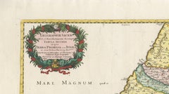
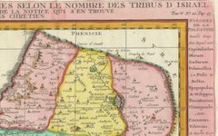
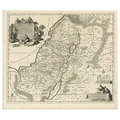
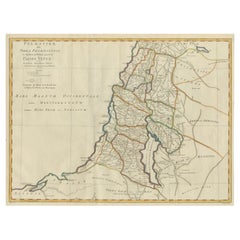
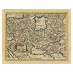
Sanson & Schenk Biblical Map of the Twelve Tribes of Israel, circa 1700
Located in Langweer, NL
Sanson & Schenk Biblical Map of the Twelve Tribes of Israel, circa 1700 A beautifully engraved and richly detailed antique map of the Holy Land and the Twelve Tribes of Israel, orig...
Paper
$490
H 15.4 in W 19.1 in D 0 in
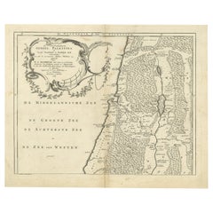
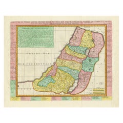
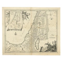
Antique Map of Northern Palestine with The Tribes of Israel. Dutch, 1763
Located in Langweer, NL
This detailed 18th-century engraved map shows the northern section of biblical Palestine and the tribal allotments of Israel.
Paper
$362
H 13.47 in W 11.03 in D 0.01 in
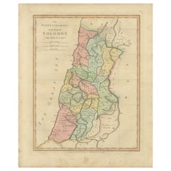
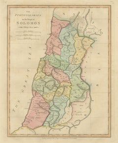
The Purveyorships in the Reign of Solomon — Biblical Map of Ancient Israel, 1798
Located in Langweer, NL
The Purveyorships in the Reign of Solomon — Biblical Map of Ancient Israel, Wilkinson 1798 This finely engraved and delicately hand-colored biblical map titled “The Purveyorships in...
Paper
$1,287
H 20.08 in W 26.78 in D 0.01 in
Antique French Map of the Holy Land, Twelve Tribes of Israel, c.1750
Located in Langweer, NL
Antique Holy Land Map, Twelve Tribes of Israel – Robert de Vaugondy, c.1750 Description This finely engraved and hand-colored map depicts Judea, or the Holy Land, divided according ...
Paper
$2,223
H 18.78 in W 27.17 in D 0.01 in
Holy Land Map of the Twelve Tribes of Israel – Sanson, Hand Colored, 1696
Located in Langweer, NL
Holy Land Map of the Twelve Tribes of Israel – Sanson, Hand Colored, 1696 Description: This impressive and richly hand-colored map of the Holy Land depicts the biblical territories ...
Paper

$1,404
H 15.75 in W 18.51 in D 0.01 in
Antique Holy Land Map, Twelve Tribes of Israel – Covens & Mortier, c.1700
Located in Langweer, NL
Antique Holy Land Map, Twelve Tribes of Israel – Covens & Mortier, c.1700 Description: This finely engraved early 18th-century map depicts the Holy Land divided according to the...
Paper
$923
H 19.1 in W 22.84 in D 0.01 in
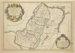
Judaea or Terra Sancta, Twelve Tribes of Israel – Sanson Map, c.1680
Located in Langweer, NL
Judaea or Terra Sancta, Twelve Tribes of Israel – Sanson Map, c.1680 This antique map depicts Judaea or the Holy Land divided among the Twelve Tribes of Israel, based on biblical ge...
Paper

$430Sale Price|20% Off
H 15.95 in W 19.49 in D 0.02 in
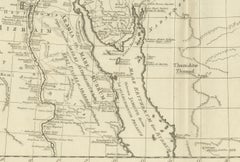
Antique Map of Eastern Turkey, Caucasus, Israel through Iraq and part of Arabia
Located in Langweer, NL
Beautiful map including eastern Turkey, the Caucasus, Israel through Iraq, with a part of Arabia.
Paper
$316
H 16.03 in W 9.85 in D 0 in
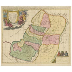
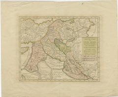
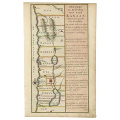
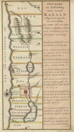
Antique Dutch Map of the Twelve Tribes of Israel – After Ezekiel, circa 1730
Located in Langweer, NL
Antique Dutch Map of the Twelve Tribes of Israel – After Ezekiel, circa 1730 This uncommon early 18th-century Dutch map is titled "Ontwerp en Erfdeeling van’t Land Kanaan, volgens h...
Paper

$561
H 19.3 in W 27.17 in D 0.01 in
Holy Land Map of the Twelve Tribes of Israel, After Sanson, Paris c.1798
Located in Langweer, NL
Large engraved biblical map of the Holy Land showing the division of the land among the Twelve Tribes of Israel, based on the cartography of Nicolas Sanson (1600–1667).
Paper
$1,156
H 21.66 in W 24.81 in D 0.01 in
1732 Henri Chatelain Map of the Holy Land Divided Among the Tribes of Israel
Located in Langweer, NL
Title: 1732 Henri Chatelain Map of the Holy Land Divided Among the Tribes of Israel This exquisite 18th-century map by Henri Chatelain, published in 1732, offers a detailed depict...
Paper

$645Sale Price|20% Off
H 14.77 in W 21.58 in D 0 in
Original Rare Map of the Holy Land Showing the Twelve Tribes of Israel's, 1782
Located in Langweer, NL
Antique map titled 'Carte des Douze Tribus D'Israel (..).'
Paper

$449Sale Price|20% Off
H 17.72 in W 20.28 in D 0 in
Highly Detailed Antique Map of the Holy Land Showing 12 Tribes of Israel, c.1720
Located in Langweer, NL
Antique map titled 'Heylige Land verdeeld in de Twaalf Stammen Israels (..).'
Paper
$432
H 14.45 in W 9.06 in D 0 in
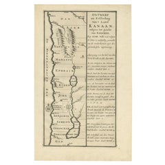
Hand-Colored Dutch Map of Ancient Israel Divided by the Twelve Tribes – c.1730
Located in Langweer, NL
The map depicts ancient Israel from Hethelon in the north to Kades in the south, laid out in horizontal bands representing the territories of the Twelve Tribes of Israel.
Paper

$608Sale Price|20% Off
H 15.16 in W 12.01 in D 0.01 in
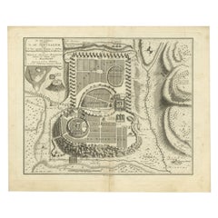
Antique Detailed Map of Jerusalem in Israël with Extensive Key and Scale, 1698
Located in Langweer, NL
Antique map titled 'Jerusalem.' Plan of the ancient city of Jerusalem. With extensive key and scale. Source unknown, to be determined. Artists and Engravers: Made by 'Cornelis de...
Paper
$3,458Sale Price / set|20% Off
H 28.15 in W 18.51 in D 0.01 in
1658 Large Map of the Holy Land by Jansson – Twelve Tribes of Israel in 6 Sheets
Located in Langweer, NL
The map is based on the influential work of Christian van Adrichom, whose 1590 design became the standard for visualizing the biblical divisions of the land of Israel among the Twelv...
Paper

$877
H 19.18 in W 15.6 in D 0 in
Bird's-Eye Plan of Jerusalem in Israël, a Rare Original Engraving, 1750
Located in Langweer, NL
Bird's-eye plan of Jerusalem in Israel. This map shows the most important buildings and locations, including the City of David, Golgatha, and the Temple of Mount Moriah.
Paper
$421
H 7.45 in W 10.44 in D 0.01 in
Antique Map of the Holy Land Palestine & Jerusalem, Elias Baeck ca. 1700
Located in Langweer, NL
It works beautifully as part of a Holy Land collection or alongside other early maps of the Mediterranean and Near East. Keywords: Jerusalem, Palestine, Holy Land, Israel, Judaea, S...
Paper

$1,872
H 20.6 in W 26.19 in D 0.01 in
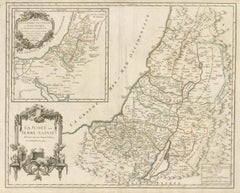
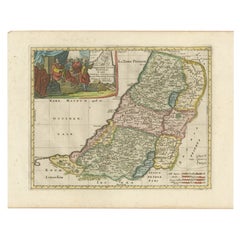
1750 Map of the Holy Land: The Land of Canaan and the Twelve Tribes
Located in Langweer, NL
The division of the Twelve Tribes of Israel was a common theme in Holy Land maps, aiming to provide a visual aid to readers and scholars interpreting biblical texts.
Paper
$959
H 18.51 in W 23.35 in D 0.01 in
1773 John Blair Map of the Ancient Holy Land: Tribes, Journeys, and Empires
Located in Langweer, NL
Title: 1773 John Blair Map of the Ancient Holy Land: Tribes, Journeys, and Empires This exceptional map by John Blair, published in London in 1773, offers a richly detailed view o...
Paper


$747
H 18.12 in W 14.38 in D 0.01 in
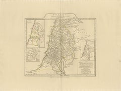
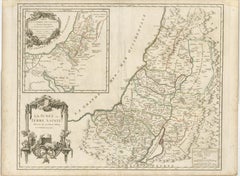
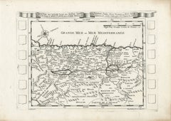
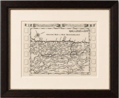
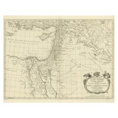
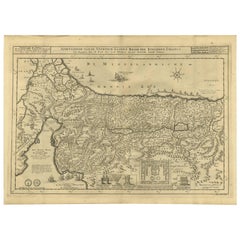
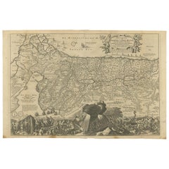
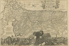
1720 Maps of the Holy Land: Ancient and Modern by De Fer and Danet
Located in Langweer, NL
The extensive notes in French provide valuable insights into the area's political and geographical landscape during this period. The second map, "Descriptio Acurata Terrae Promiss...
Paper
$572 / set
H 30.32 in W 20.28 in D 0.01 in
Antique Holy Land Map, Terrae Sanctae Tabula – Guillaume De L’Isle, 1782
Located in Langweer, NL
Dark walnut or ebony frame with ivory or warm cream mat enhances the antique tonal range and suits both classic and contemporary interiors. We well the maps unframed. Technique: Co...
Paper
$1,400
H 5.04 in W 4.53 in D 2.29 in
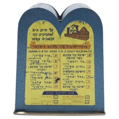
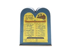
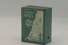
A Charity Container for the Bnei Akiva Organization , Israel 1950
Located in New York, NY
On each of its sides is a map of Israel and a shining sun with individual rays extending to the exact numbered locations the organization supports in Hebrew and English.
Metal
Sold
H 39.38 in W 24.61 in L 39.38 in
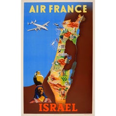
Original Vintage Colourful Travel Map Poster by Renluc for Air France Israel
By Renluc
Located in London, GB
Original vintage Air France travel advertising poster for Israel featuring a plane flying over the Mediterranean Sea towards a colorful map of Israel in the Middle East with images d...
Paper

Antique Map of the Biblical Kingdom of Israel by Lindeman, c.1758
Located in Langweer, NL
Map of the biblical Kingdom of Israel under the Kings Saul, David and Solomon.
Paper
Sold
H 17.72 in W 22.84 in D 0 in
Antique Map of the Departure of the Children of Israel for Egypt, 1669
Located in Langweer, NL
Antique map titled 'Sortie des Enfans D'Israel hors D'Egypte leur Passage Par la Mer Rouge.'
Paper
Sold
H 17.72 in W 20.28 in D 0 in
Antique Map of the Holy Land, Divided into 12 Tribes of Israel, C.1720
Located in Langweer, NL
Antique map titled 'Heylige Land verdeeld in de Twaalf Stammen Israels (..).'
Paper
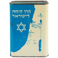
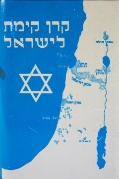
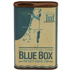
Early 20th Century Large JNF Tin Charity Box
Located in New York, NY
Decorated with a Star of David and the map of Israel in Hebrew on one side, and KKL for Keren Kayemet Yisrael, spelled out in Hebrew, on the other side with a handle for collecting.
Metal
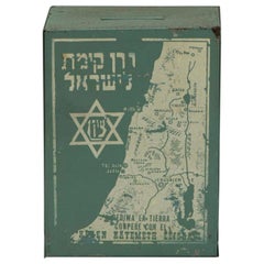
Early 20th Century South American JNF Iron Charity Box
Located in New York, NY
Extremely rare South American Iron JNF/KKL Charity box, circa 1920. Decorated with a map of Israel, Star of David with the word Zion inside, and titled in Hebrew "Keren Kayemeth LeIs...
Iron
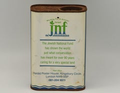
Mid-20th Century English JNF Tin Charity Box
Located in New York, NY
Decorated in the front with the map of Israel with JNF insignia and above the slogan: "working for a greener Israel".
Metal
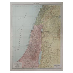

Large Original Vintage Map of Israel, circa 1920
Located in St Annes, Lancashire
Great map of Israel Original color. Good condition Published by Alexander Gross Unframed.
Paper

Large Original Vintage Map of Israel, circa 1920
Located in St Annes, Lancashire
Great map of Israel Original color. Good condition Published by Alexander Gross Unframed.
Paper

Large Original Vintage Map of Israel, circa 1920
Located in St Annes, Lancashire
Great map of Israel Original color. Good condition Published by Alexander Gross Unframed.
Paper

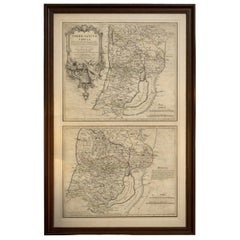
Large Original Antique Map of Israel by William Hughes, 1847
Located in St Annes, Lancashire
Great map of Israel Drawn and engraved by William Hughes Steel engraving Original colour outline Published by A & C Black. 1847 Unframed Free shipping
Paper
Antique Bible Map of Israel by A. Schut, 1743
Located in Langweer, NL
Decorative map of the Holy Land divided into the 12 Tribes of Israel, depicting the Exodus from Egypt and the wanderings of the Children of Israel.

Antique Map of the Twelve Tribes of Israel
Located in Langweer, NL
This large map shows the twelve tribes of Israel and the kingdoms of Judea and Israel.
Paper

Sold
H 15.75 in W 19.69 in D 0.01 in
1709 Map of the Holy Land - Twelve Tribes of Israel, Hand-Colored, Antique Map
Located in Langweer, NL
Both cartouches are crisp and well-preserved, enhancing the map’s visual appeal. --- Keywords: - Holy Land map - Twelve Tribes of Israel - Biblical cartography - Guillaume Sanson m...
Paper
Antique Map Travel Children of Israel by Keur, 1748
Located in Langweer, NL
This map illustrates the travel of the children of Israel from Egypt through the Red Sea and the desert to the Promised Lands Canaan.
Paper


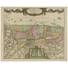
Religious Antique Map of the Twelve Tribes of Israel, circa 1750
Located in Langweer, NL
The map divides the region into the territories of the Twelve Tribes of Israel, as well as featuring the neighbouring kingdoms and nations of Egypt, the Edomites, the Nabataeans, the...
Paper

Sold
H 15.16 in W 18.51 in D 0 in
Antique Map of Biblical Palestine with Inset of Israel's 12 Tribes, 1758
Located in Langweer, NL
Map of biblical Palestine. Inset map of the land of Israel divided in 12 tribes according to Ezekiel in the Old Testament.
Paper

Sold
H 9.65 in W 12.49 in D 0.01 in
Sacred Map of the Promised Land, Twelve Tribes of Israel, Sanson, 1705
Located in Langweer, NL
It offers a reduced depiction of Sanson’s elder map of the Promised Land, carefully illustrating the division of the land among the Twelve Tribes of Israel.
Paper
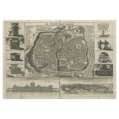

Antique Map of the Holy City Jerusalem in Israël, c.1700
Located in Langweer, NL
Antique map of the Holy City titled 'De Stadt Ierusalem'. Rare state of this bird's eye plan of the holy city flanked by engravings of religious icons. At the bottom are an elevati...
Paper

Antique Map of the Holy Land, Israel by J.B. Elwe, 1792
Located in Langweer, NL
The Mediterranean is filled with various types of ships and boats, including a depiction of Jonah and the whale. The map is divided into the twelve tribes of Israel.
Paper

Sold
H 9.73 in W 14.85 in D 0.02 in
Antique Map of Modern-Day Armenia, Iran, Iraq, Syria, Israel and Surroundings
Located in Langweer, NL
Detailed regional map of modern day Armenia, Iran, Iraq, Syria, Israel, Jordan, Turkmenistan, Afghanistan and part of Pakistan.
Paper


Sold
H 13.86 in W 17.13 in D 0.01 in
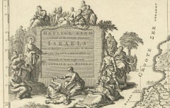
1720 Weigel & Köhler Engraving of the Camp of the 12 Tribes of Israel
Located in Langweer, NL
Title: 1720 Weigel & Köhler Engraving of the Camp of the 12 Tribes of Israel This captivating 18th-century engraving by Christoph Weigel and Johann David Köhler illustrates the ca...
Paper

Sold
H 15.16 in W 19.3 in D 0 in
The Biblical Kingdom of Israel under the Kings Saul, David and Solomon, Ca.1758
Located in Langweer, NL
Map of the biblical Kingdom of Israel under the Kings Saul, David and Solomon.
Paper
Antique and vintage collectibles and curiosities can bring whimsy and wonder to any interior.
Decorating with old scientific instruments, historical memorabilia and vintage musical instruments, as well as other authentic collectibles and curiosities that can be found on 1stDibs, presents an opportunity to create a unique, natural history museum-like atmosphere in your home that can provoke conversation as often as it pays tribute to how far we’ve come in understanding our world.
And bringing collectibles and curiosities into your space is actually on trend — Wunderkammern, or curiosity cabinets, were all the rage in Europe during the 1500s and continued to have adherents there and in the U.S. in the following centuries. Today, however, they’re experiencing a real surge in popularity and influencing how many interior designers are furnishing and decorating homes — combining contemporary with antique, scientific with tribal, earthly with extraterrestrial, Les Lalanne tables with Flemish tapestries.
The original Wunderkammern were entire rooms filled with objects demonstrating their owners’ worldly knowledge: A proper one included artificiala or preciosa (objets d’art); naturalia (such as skeletons, shells, minerals); exotica (taxidermy or dried plants); and scientifica (scientific instruments), frequently alongside religious relics and ancient artifacts.
Pay tribute to a history of rich and diverse musical traditions that have taken shape all over the world by decorating your home with a collection of antique and vintage musical instruments — with a little help from strong hanging wire or some wall hooks, vintage brass instruments such as a gong, French horn or trumpet can help elevate a home office or complement the efforts you’ve made to ensure a welcoming vibe in your home’s entryway. Bells or antique wind instruments can add provocative metallic contrasts to dark woods as tabletop decorative objects.
Create an intriguing focal point with Georgian scientific instruments, such as stick barometers with mahogany cases or lacquered brass telescopes. These items stem from an era named for the monarchies of the four King Georges, who ruled England in succession starting in 1714 (plus King William’s reign, which lasted until 1837). Just as there was beautiful jewelry produced during the period that today is coveted by collectors, there is much to be found in the collectibles and curiosities realm too.
Wanderlust, nostalgia and a shared love of good design are contributing factors to certain trends in decorating — just as vintage trunks and luggage have reappeared as furniture or home accents in a bedroom or foyer, decorating with globes, maps or nautical objects is similarly rooted in the allure of travel and a penchant for the stylish finishing touch that collectibles bring to our homes.
Find a wide range of antique and vintage collectibles and curiosities on 1stDibs.
It's hard to resist the allure of a beautiful pool. So, go ahead and daydream about whiling away your summer in paradise.
It’s never too early for good design. These interiors combine elevated furnishings and a youthful spirit, resulting in spaces that are at once elegant and whimsical.
Produced in 1843, the well-preserved volume is evidence of the author's exacting specifications.
New or old, the coverlets add old-time charm to any space.
Get into the games! These items celebrate the events, athletes, host countries and sporting spirit.
French trendsetter and serial collector Daniel Rozensztroch tells us about his obsession with objects related to seafaring men.
The sought-after designer worked with the team at Hoffman Creative to produce a monograph that beautifully showcases some of Studio Shamshiri's most inspiring projects.
Italian writer and collector Umberto Pasti opens the doors to his remarkable cave of wonders in North Africa.