Items Similar to Antique Map of Dutch Cities Haarlem, Zandvoort, Bloemendaal, Wijk aan Zee, 1884

Want more images or videos?
Request additional images or videos from the seller
1 of 5
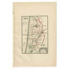
Antique Map of Dutch Cities Haarlem, Zandvoort, Bloemendaal, Wijk aan Zee, 1884
$226.84
$283.5520% Off
£170.03
£212.5420% Off
€192
€24020% Off
CA$311.64
CA$389.5520% Off
A$347.91
A$434.8920% Off
CHF 182.30
CHF 227.8820% Off
MX$4,258.82
MX$5,323.5220% Off
NOK 2,315.24
NOK 2,894.0520% Off
SEK 2,182.98
SEK 2,728.7220% Off
DKK 1,461.57
DKK 1,826.9720% Off
About the Item
Antique map titled 'Haarlem en Omstreken'. Old map of the region of Haarlem also including cities and villages like Wijk aan Zee, Beverwijk, Bloemendaal and Zandvoort. This map orginates from 'Atlas behoorende bij Wandelingen door Nederland met Pen en Potlood'. Artists and Engravers: Author: J. Craandijk. Published by H.D. Tjeenk Willink, Haarlem.
Artist: Author: J. Craandijk. Published by H.D. Tjeenk Willink, Haarlem.
Condition: Good, general age-related toning. Minor defects from handling, please study image carefully.
Date: 1884
Overall size: 17.9 x 26.6 cm.
Image size: 10.4 x 15.6 cm.
We sell original antique maps to collectors, historians, educators and interior decorators all over the world. Our collection includes a wide range of authentic antique maps from the 16th to the 20th centuries. Buying and collecting antique maps is a tradition that goes back hundreds of years. Antique maps have proved a richly rewarding investment over the past decade, thanks to a growing appreciation of their unique historical appeal. Today the decorative qualities of antique maps are widely recognized by interior designers who appreciate their beauty and design flexibility. Depending on the individual map, presentation, and context, a rare or antique map can be modern, traditional, abstract, figurative, serious or whimsical. We offer a wide range of authentic antique maps for any budget.
- Dimensions:Height: 10.48 in (26.6 cm)Width: 7.05 in (17.9 cm)Depth: 0 in (0.01 mm)
- Materials and Techniques:
- Period:
- Date of Manufacture:1884
- Condition:
- Seller Location:Langweer, NL
- Reference Number:Seller: BG-00954-131stDibs: LU3054326498332
About the Seller
5.0
Recognized Seller
These prestigious sellers are industry leaders and represent the highest echelon for item quality and design.
Platinum Seller
Premium sellers with a 4.7+ rating and 24-hour response times
Established in 2009
1stDibs seller since 2017
2,513 sales on 1stDibs
Typical response time: <1 hour
- ShippingRetrieving quote...Shipping from: Langweer, Netherlands
- Return Policy
Authenticity Guarantee
In the unlikely event there’s an issue with an item’s authenticity, contact us within 1 year for a full refund. DetailsMoney-Back Guarantee
If your item is not as described, is damaged in transit, or does not arrive, contact us within 7 days for a full refund. Details24-Hour Cancellation
You have a 24-hour grace period in which to reconsider your purchase, with no questions asked.Vetted Professional Sellers
Our world-class sellers must adhere to strict standards for service and quality, maintaining the integrity of our listings.Price-Match Guarantee
If you find that a seller listed the same item for a lower price elsewhere, we’ll match it.Trusted Global Delivery
Our best-in-class carrier network provides specialized shipping options worldwide, including custom delivery.More From This Seller
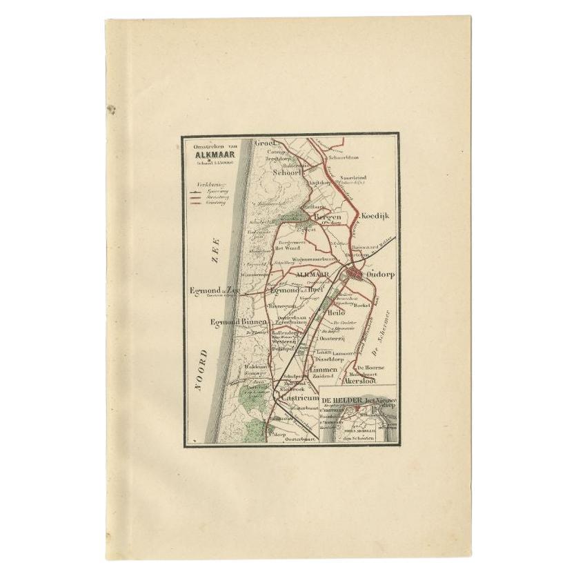
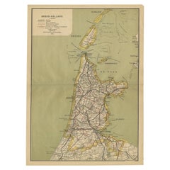
View AllAntique Map of the Region of Alkmaar by Craandijk, 1884
Located in Langweer, NL
Antique map titled 'Omstreken van Alkmaar'. Old map of the region of Alkmaar also including cities and villages like Castricum, Egmond, Oudorp and Den Helder. This map orginates from...
Category
Antique 19th Century Maps
Materials
Paper
$82 Sale Price
20% Off
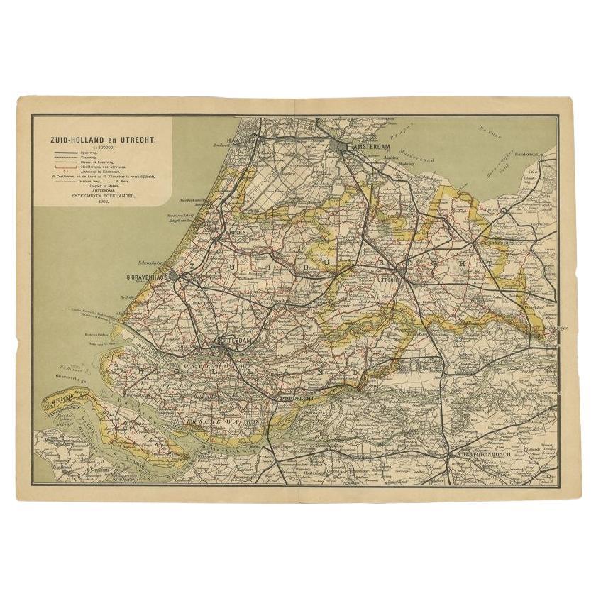
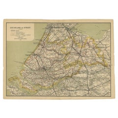
Antique Map of Zuid-Holland and Utrecht in The Netherlands, 1902
Located in Langweer, NL
Antique map titled 'Zuid-Holland en Utrecht'. Lithographed map of the provinces of Zuid-Holland and Utrecht, the Netherlands. This map originates from 'Atlas van Nederland'.
Artist...
Category
20th Century Maps
Materials
Paper
$122 Sale Price
20% Off
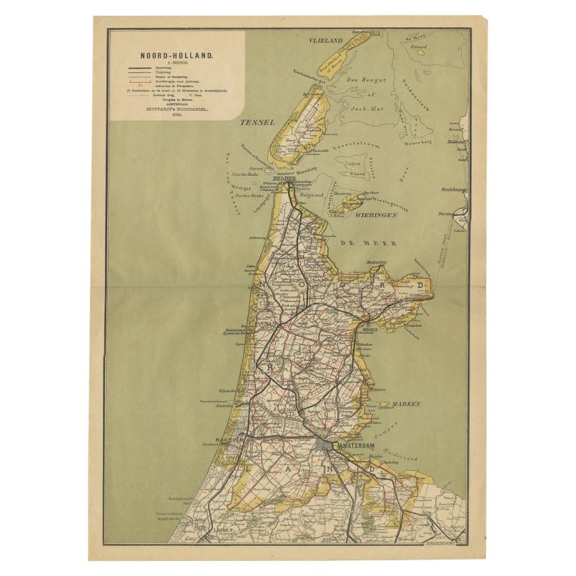
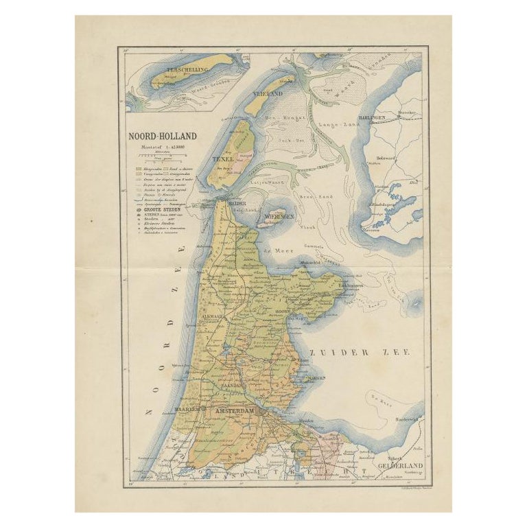
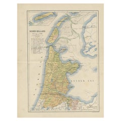
Antique Map of Noord-Holland, Province of The Netherlands, 1902
Located in Langweer, NL
Antique map titled 'Noord-Holland'. Lithographed map of the province of Noord-Holland, the Netherlands. This map originates from 'Atlas van Nederland'. Artists and Engravers: Publish...
Category
20th Century Maps
Materials
Paper
$122 Sale Price
20% Off
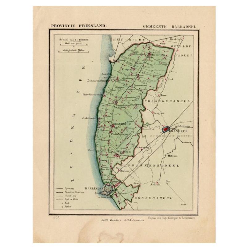
Antique Map of Barradeel, a County in Friesland, The Netherlands, 1868
Located in Langweer, NL
Antique map titled 'Provincie Friesland - Gemeente Barradeel or Barradiel. Map of the township Barradeel including Sexbierum, Harlingen and many other villages. This map originates f...
Category
Antique 19th Century Maps
Materials
Paper

$132 Sale Price
20% Off
Antique Map of the Dutch Province of Noord-Holland, 1883
Located in Langweer, NL
Antique map titled 'Noord-Holland'. Map of Noord-Holland, a province of the Netherlands. This map originates from 'Atlas van Nederland volgens de nieuwe spelregels' by J. Kuyper. Art...
Category
Antique 19th Century Maps
Materials
Paper
$127 Sale Price
20% Off
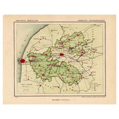
Antique Map of Franekeradeel, Township in Friesland, The Netherlands, 1868
Located in Langweer, NL
Antique map titled 'Provincie Friesland - Gemeente Franekeradeel'.
Map of the township of Franekeradeel including Franeker, Achlum, Dongjum, Midlum and many other villages. This ...
Category
Antique 19th Century Maps
Materials
Paper
$122 Sale Price
20% Off
You May Also Like
The Netherlands (Holland), Belgium and Luxemburg. Century Atlas antique map
Located in Melbourne, Victoria
'The Century Atlas. The Netherlands (Holland), Belgium and Luxemburg.'
Original antique map, 1903.
Inset maps of 'Amsterdam' and 'Brussels'.
Central fold as issued. Map name and num...
Category
Early 20th Century Victorian More Prints
Materials
Lithograph

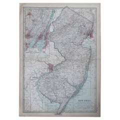
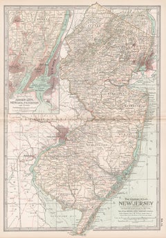
Original Antique Map of the American State of New Jersey, 1903
Located in St Annes, Lancashire
Antique map of New Jersey
Published By A & C Black. 1903
Original colour
Good condition
Unframed.
Free shipping
Category
Antique Early 1900s English Maps
Materials
Paper
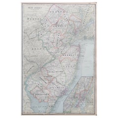
Large Original Antique Map of New Jersey, USA, circa 1900
Located in St Annes, Lancashire
Fabulous map of New Jersey
Original color
Engraved and printed by the George F. Cram Company, Indianapolis.
Published, circa 1900
Unframed
Repairs to minor edge tears
Category
Antique 1890s American Maps
Materials
Paper
New Jersey. USA Century Atlas state antique vintage map
Located in Melbourne, Victoria
'The Century Atlas. New Jersey'
Original antique map, 1903.
Central fold as issued. Map name and number printed on the reverse corners.
Sheet 40cm by 29.5cm.
Category
Early 20th Century Victorian More Prints
Materials
Lithograph
Large Original Antique Map of New York State( Southern ), USA, C.1900
Located in St Annes, Lancashire
Fabulous map of Southern New York . With a vignette of Lower Manhattan
Original color.
Engraved and printed by the George F. Cram Company, Indianapolis.
Published, C.1900.
Unfram...
Category
Antique 1890s American Maps
Materials
Paper

Original Antique Map or City Plan of Amsterdam, Netherlands. Circa 1835
Located in St Annes, Lancashire
Nice map of Amsterdam
Drawn and engraved by J.Dower
Published by Orr & Smith. C.1835
Unframed.
Free shipping
Category
Antique 1830s English Maps
Materials
Paper

More Ways To Browse
1884 Collection
Victorian Compass
Antique Maps Caribbean Islands
Goa Furniture
George Fleet
Sri Lanka Map
Philippines Map
Antique Map Ceylon
Antique Sri Lanka Map
Persian Maps
Antique Civil War Maps
Antique Map Of The Philippines
Large Map Of Italy
Used Marine Compass
West Indies Colonial
Antique Pamphlets
Sicily Map
Thailand Map