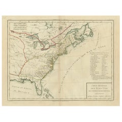
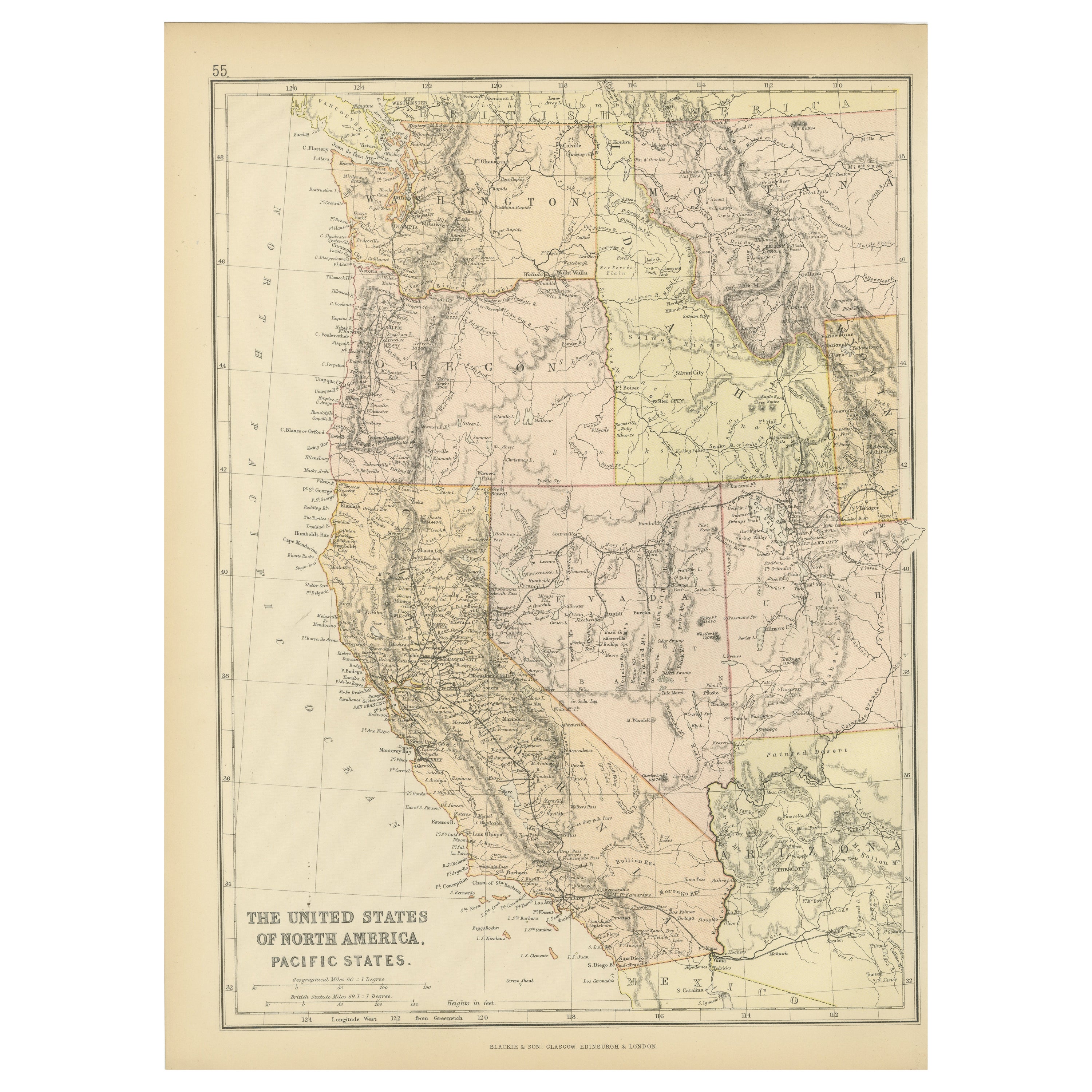
Antique Map of the Early United States by Pierre Antoine Tardieu (1784-1869)
View Similar Items


Want more images or videos?
Request additional images or videos from the seller
1 of 8
Antique Map of the Early United States by Pierre Antoine Tardieu (1784-1869)
Price:$341.38
$533.02List Price
About the Item
- Dimensions:Height: 16.34 in (41.5 cm)Width: 22.25 in (56.5 cm)Depth: 0.01 in (0.2 mm)
- Materials and Techniques:Paper,Engraved
- Period:
- Date of Manufacture:1802
- Condition:Good condition with minor age-related wear. Hand-colored boundaries are well-preserved, enhancing the clarity of regions and features. Fold lines as issued with lower end a split. Edge wear due to handling and age visible. Study the images carefully.
- Seller Location:Langweer, NL
- Reference Number:Seller: BG-13769-341stDibs: LU3054340566232
About the Seller
5.0
Recognized Seller
These prestigious sellers are industry leaders and represent the highest echelon for item quality and design.
Platinum Seller
Premium sellers with a 4.7+ rating and 24-hour response times
Established in 2009
1stDibs seller since 2017
2,565 sales on 1stDibs
Authenticity Guarantee
In the unlikely event there’s an issue with an item’s authenticity, contact us within 1 year for a full refund. DetailsMoney-Back Guarantee
If your item is not as described, is damaged in transit, or does not arrive, contact us within 7 days for a full refund. Details24-Hour Cancellation
You have a 24-hour grace period in which to reconsider your purchase, with no questions asked.Vetted Professional Sellers
Our world-class sellers must adhere to strict standards for service and quality, maintaining the integrity of our listings.Price-Match Guarantee
If you find that a seller listed the same item for a lower price elsewhere, we’ll match it.Trusted Global Delivery
Our best-in-class carrier network provides specialized shipping options worldwide, including custom delivery.More From This Seller
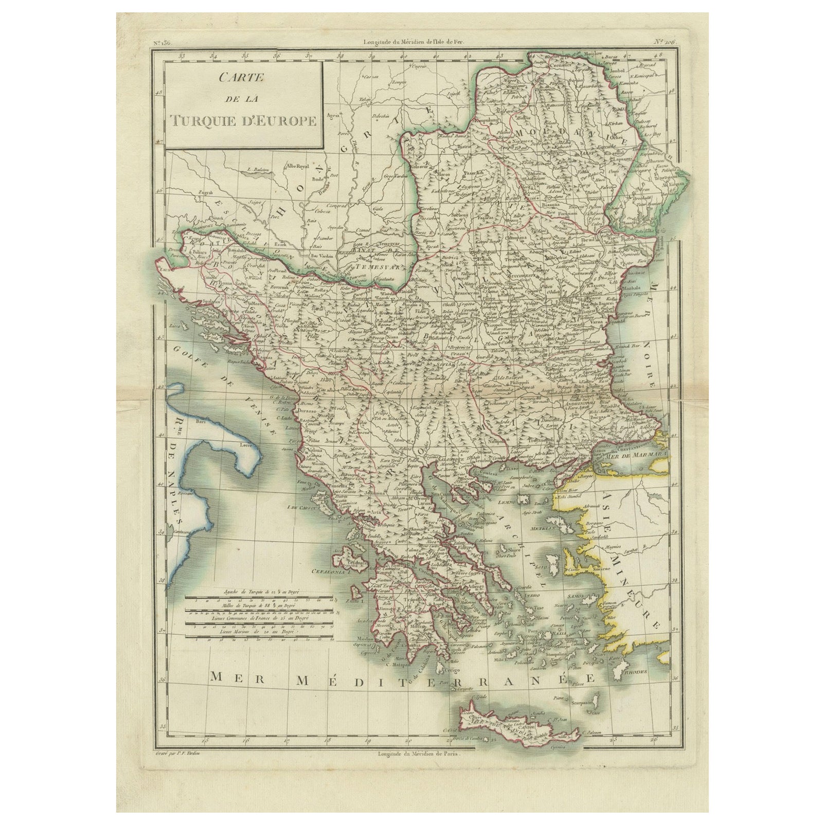
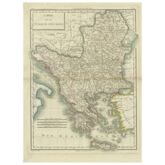
View AllGenuine Antique Map of European Turkey by Pierre Antoine Tardieu (1784-1869)
Located in Langweer, NL
This is an original antique map titled "Carte de la Turquie d'Europe," which depicts the European territories of the Ottoman Empire. The map features detailed geographical and political boundaries, showcasing various regions, cities, rivers, and mountains within the Ottoman European territories. The map was created by Pierre Antoine Tardieu, a renowned French engraver, steel engraver, and cartographer known for his high-quality work.
Map Details:
- **Title**: Carte de la Turquie d'Europe
- **Creator**: Pierre Antoine Tardieu (1784-1869)
- **Publication Date**: Early 19th century
- **Dimensions**: Approximately 34.5 x 43.5 cm (13.5 x 17.25 inches)
- **Features**: The map includes a detailed representation of the European territories of the Ottoman Empire, with place names, rivers, mountains, and regions clearly marked. The title cartouche is located in the upper left corner, and the mile scale is presented in the lower left.
Around the year 1800, the region referred to as "European Turkey" or "Ottoman Europe" was a significant part of the Ottoman Empire, which was one of the most powerful empires in the world at the time. Here are some key aspects of European Turkey during this period:
### Geographic Scope
European Turkey included a large part of Southeastern Europe, encompassing modern-day:
- Greece
- Bulgaria
- Romania (specifically the regions of Dobruja and parts of Wallachia)
- Serbia
- Albania
- Montenegro
- Bosnia and Herzegovina
- Parts of Croatia, Macedonia, and Hungary
Political Structure
- **Ottoman Administration**: The region was governed by the Ottoman administrative system, which divided territories into provinces (vilayets) and smaller administrative units (sanjaks). Each province was overseen by a governor (pasha) appointed by the Sultan.
- **Autonomy and Vassal States**: Some areas within European Turkey had varying degrees of autonomy or were vassal states. For example, Wallachia and Moldavia (in modern-day Romania) were vassal principalities that retained local rulers under Ottoman suzerainty.
Society and Demographics
- **Ethnic Diversity**: The region was extremely diverse, home to numerous ethnic groups, including Turks, Greeks, Bulgarians, Serbs, Albanians, Vlachs (Romanians), and Jews, among others.
- **Religious Diversity**: There was significant religious diversity, with Islam being the dominant religion due to Ottoman rule, but large Christian (Eastern Orthodox, Roman Catholic) and Jewish populations coexisted.
Economy
- **Agriculture**: The economy was largely agrarian, with agriculture being the primary occupation. Key crops included grains, tobacco, and cotton.
- **Trade and Commerce**: European Turkey was strategically important for trade, connecting the Mediterranean with Central Europe and the Black Sea. Major cities like Constantinople (modern-day Istanbul), Thessaloniki, and Belgrade were key commercial hubs.
Culture
- **Cultural Influence**: The region was a melting pot of various cultures, influenced by Byzantine, Slavic, and Ottoman traditions. This mix was reflected in architecture, cuisine, music, and customs.
- **Education and Language**: The official language of administration was Ottoman Turkish, but many local languages were spoken. Education was often conducted in religious institutions, with different communities maintaining their own schools.
Challenges and Conflicts
- **Internal Strife**: The Ottoman Empire faced numerous internal challenges, including administrative inefficiency, corruption, and local uprisings.
- **External Threats**: The empire was also under pressure from external forces, particularly from the Habsburg Empire, Russia, and later from nationalist movements within the Balkans, which sought independence or autonomy from Ottoman rule.
Decline of Ottoman Power
By 1800, the Ottoman Empire was experiencing a gradual decline, which would intensify throughout the 19th century. This period saw increasing nationalist sentiments among various ethnic groups within European Turkey, leading to uprisings and eventual wars of independence, such as the Serbian Revolution (1804-1835) and the Greek War of Independence (1821-1829).
Overall, European Turkey around 1800 was a complex and diverse region under the Ottoman Empire's waning control, characterized by a rich tapestry of cultures, economic activities, and political structures.
Condition Overview:
1. **Paper Quality**: The map exhibits signs of aging, such as yellowing along the edges, which is typical for documents of this age. The paper remains in good condition without major tears or damage.
2. **Edges and Corners**: The edges are slightly worn, with minor fraying and a few small tears that do not significantly impact the map's readability or aesthetic value.
3. **Center Fold**: There is a visible center fold, common for maps that were folded for storage or publication. The fold is in good condition without significant wear but with splits on both sidess.
4. **Color and Print Quality**: The colors used to outline the boundaries remain vibrant and clear. The print quality is excellent, with sharp, legible text and detailed illustrations.
5. **Staining and Spots**: There are a few spots and stains, particularly near the edges and along the fold. These do not obscure any critical details of the map.
Historical and Artistic Value:
Pierre Antoine Tardieu was known for his meticulous craftsmanship and contributions to cartography. His work drew the attention of prominent figures such as Alexander von Humboldt...
Category
Antique Early 1800s French Maps
Materials
Paper
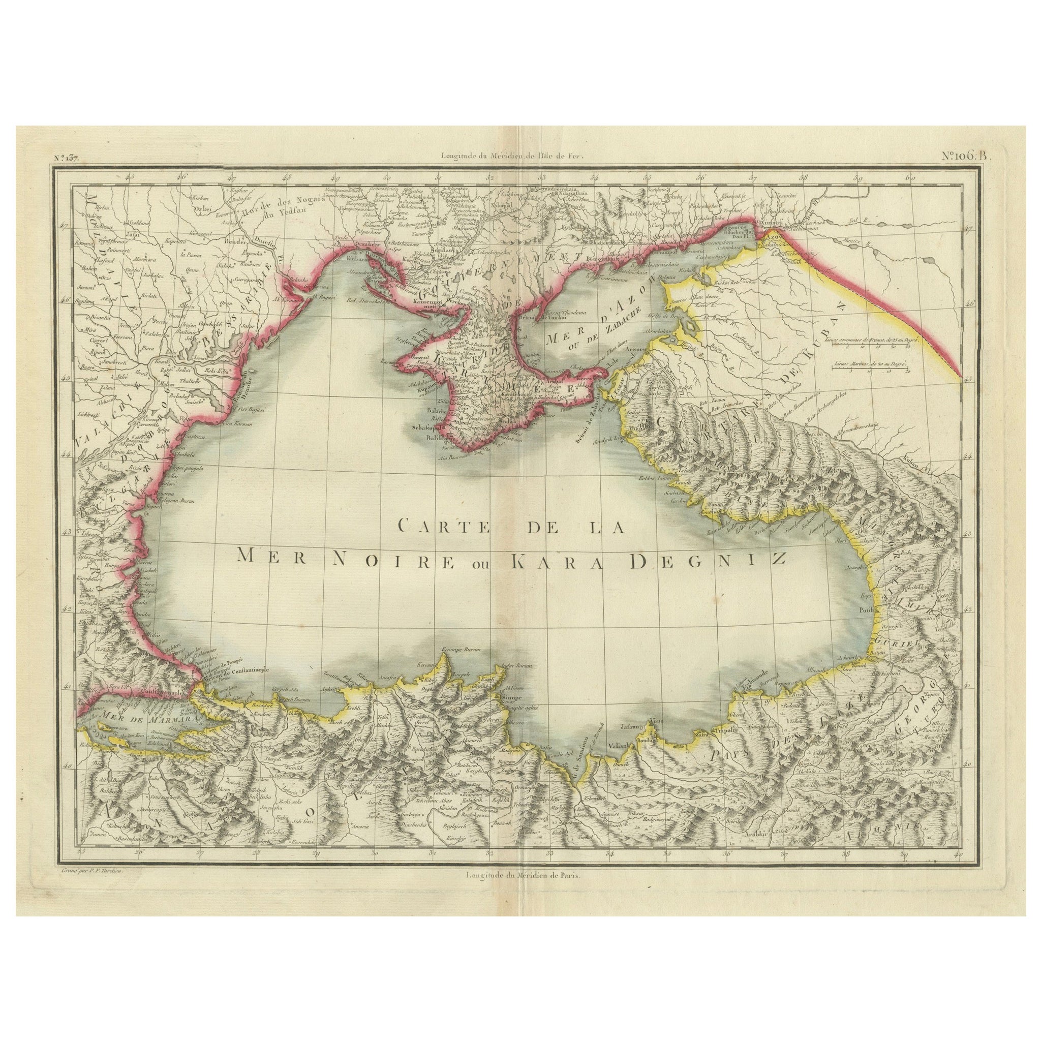
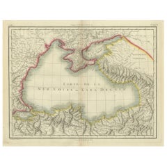
Antique Map of the Black Sea and Crimea by Pierre Antoine Tardieu (1784-1869)
Located in Langweer, NL
This is an original antique map titled "Carte de la Mer Noire ou Kara Degniz," depicting the Black Sea region. This map, created by Pierre Antoine Tardieu, highlights the geographica...
Category
Antique Early 1800s English Maps
Materials
Paper
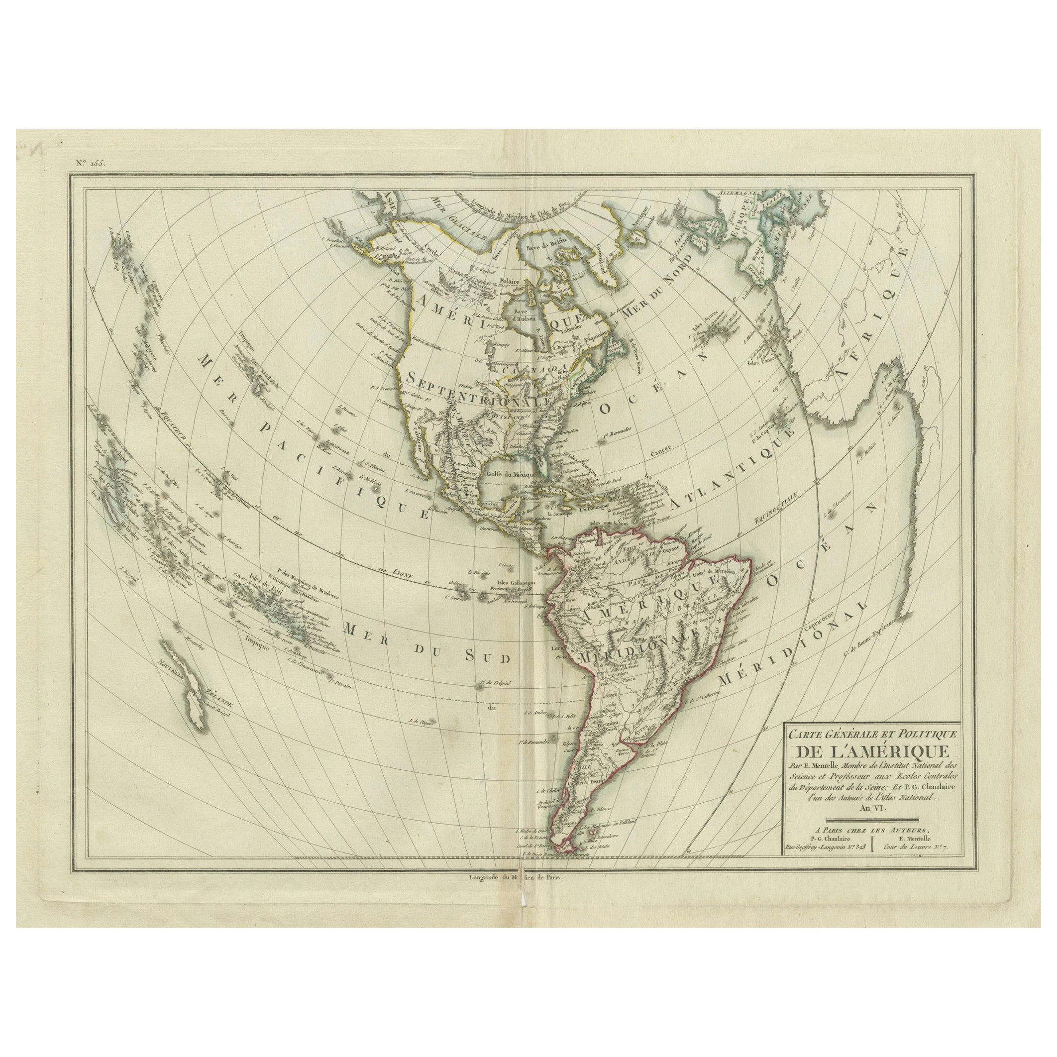
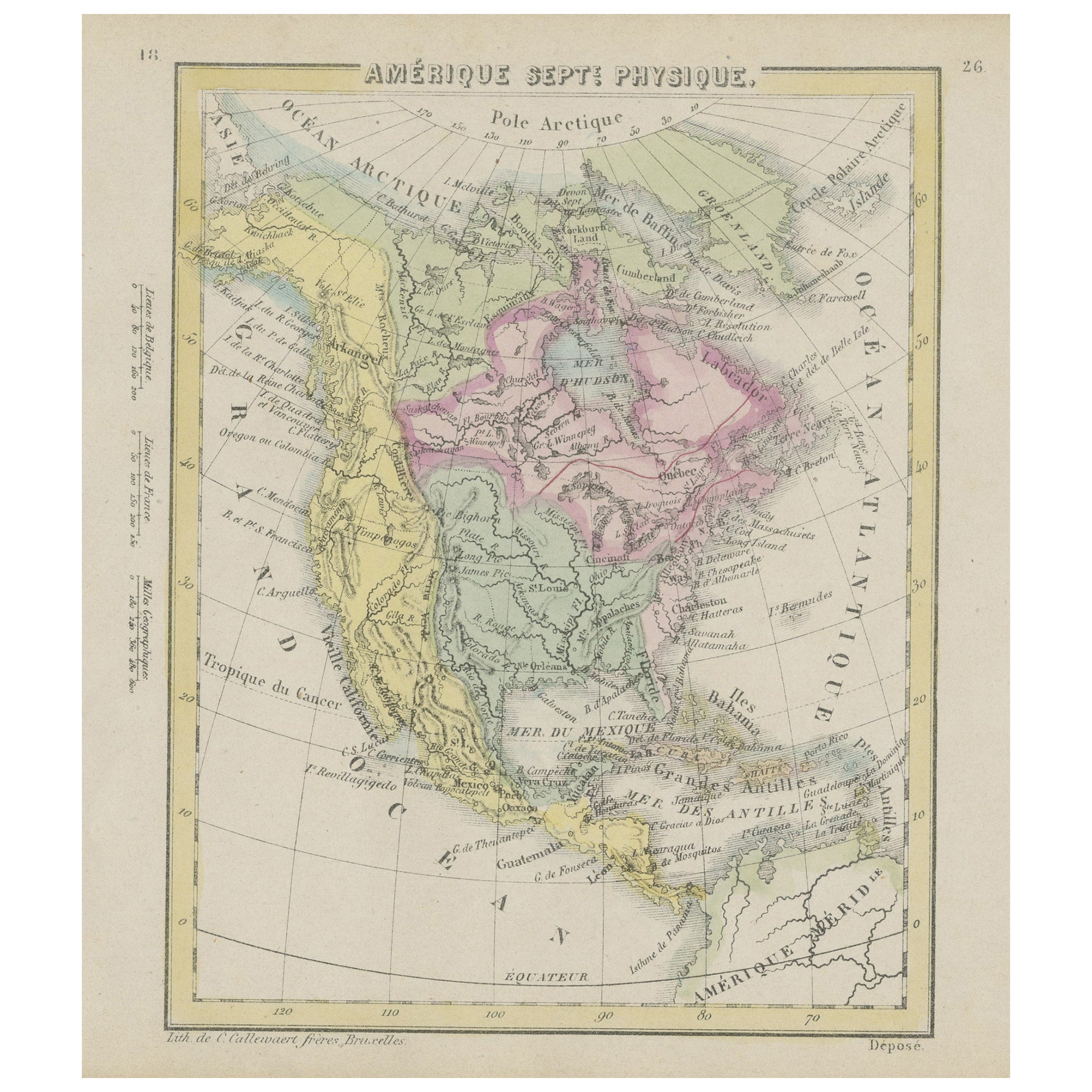
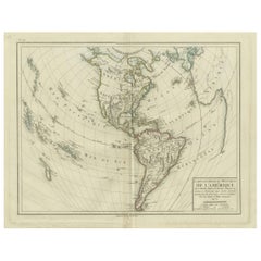
Antique Map of North and South America by Pierre Antoine Tardieu (1784-1869)
Located in Langweer, NL
This is an original antique map titled "Carte Générale et Politique de l'Amérique," depicting the political and geographical features of North and South America. This map, created by Pierre Antoine Tardieu, illustrates the continent's boundaries, major regions, and significant features as understood in the early 19th century.
Map Details:
- **Title**: Carte Générale et Politique de l'Amérique
- **Creator**: Pierre Antoine Tardieu (1784-1869)
- **Publication Date**: Early 19th century
- **Dimensions**: Approximately 34.5 x 43.5 cm (13.5 x 17.25 inches)
- **Features**: The map includes detailed representations of North and South America, highlighting political boundaries, major cities, rivers, and mountain ranges. The title cartouche is located in the lower right corner, and the outlines are hand-colored to distinguish different regions and countries.
Condition Overview:
1. Paper Quality: The paper shows typical signs of aging, such as slight yellowing, but remains in good condition without major tears or damage.
2. Edges and Corners: The edges are slightly worn, with minor fraying and small tears, particularly near the center fold. These imperfections do not significantly impact the overall readability or aesthetic value.
3. Center Fold: A center fold is present, which is common for maps of this period that were often folded for storage or publication. The fold appears intact without significant separation or damage, except for a small split at the lower end.
4. Color and Print Quality: The hand-colored outlines remain vibrant and clear, highlighting the borders of different regions. The print quality is excellent, with sharp, legible text and detailed illustrations.
5. Staining and Spots: There are a few spots and stains, particularly near the edges and along the fold. These do not obscure any critical details of the map.
Historical Context
Around the year 1800, the Americas were a region of significant political change and exploration. Here’s an overview of the region during that period:
Political Landscape
1. North America:
- United States: The United States was a young nation, having gained independence from Great Britain in 1776. The early 19th century was a period of westward expansion and the establishment of new states.
- Canada: Canada was divided into British colonies, including Upper Canada (Ontario) and Lower Canada (Quebec). The British maintained control over these territories following the American Revolution.
- Mexico: Mexico was part of the Spanish Empire, known as New Spain. It would gain independence from Spain in 1821.
2. Central and South America:
- Spanish Colonies: Much of Central and South America was under Spanish colonial rule. Significant regions included New Granada (Colombia), Peru, and the Viceroyalty of the Rio de la Plata (Argentina).
- Portuguese Brazil: Brazil was a Portuguese colony and the largest territory in South America. It would gain independence from Portugal in 1822.
- Independence Movements: The early 19th century was marked by independence movements across Latin America, led by figures such as Simón Bolívar and José de San Martín, which resulted in the creation of new nations.
3. Caribbean:
- The Caribbean islands were controlled by various European powers, including Spain, France, Great Britain, and the Netherlands. These islands were significant for their sugar plantations and as hubs of the Atlantic slave trade.
Socio-Economic Conditions
1. Trade and Commerce:
- The Americas were integral to global trade, exporting commodities such as sugar, tobacco, cotton, and coffee. The port cities of Havana, Veracruz, and Buenos Aires were crucial trade...
Category
Antique Early 1800s Maps
Materials
Paper
$494 Sale Price
20% Off
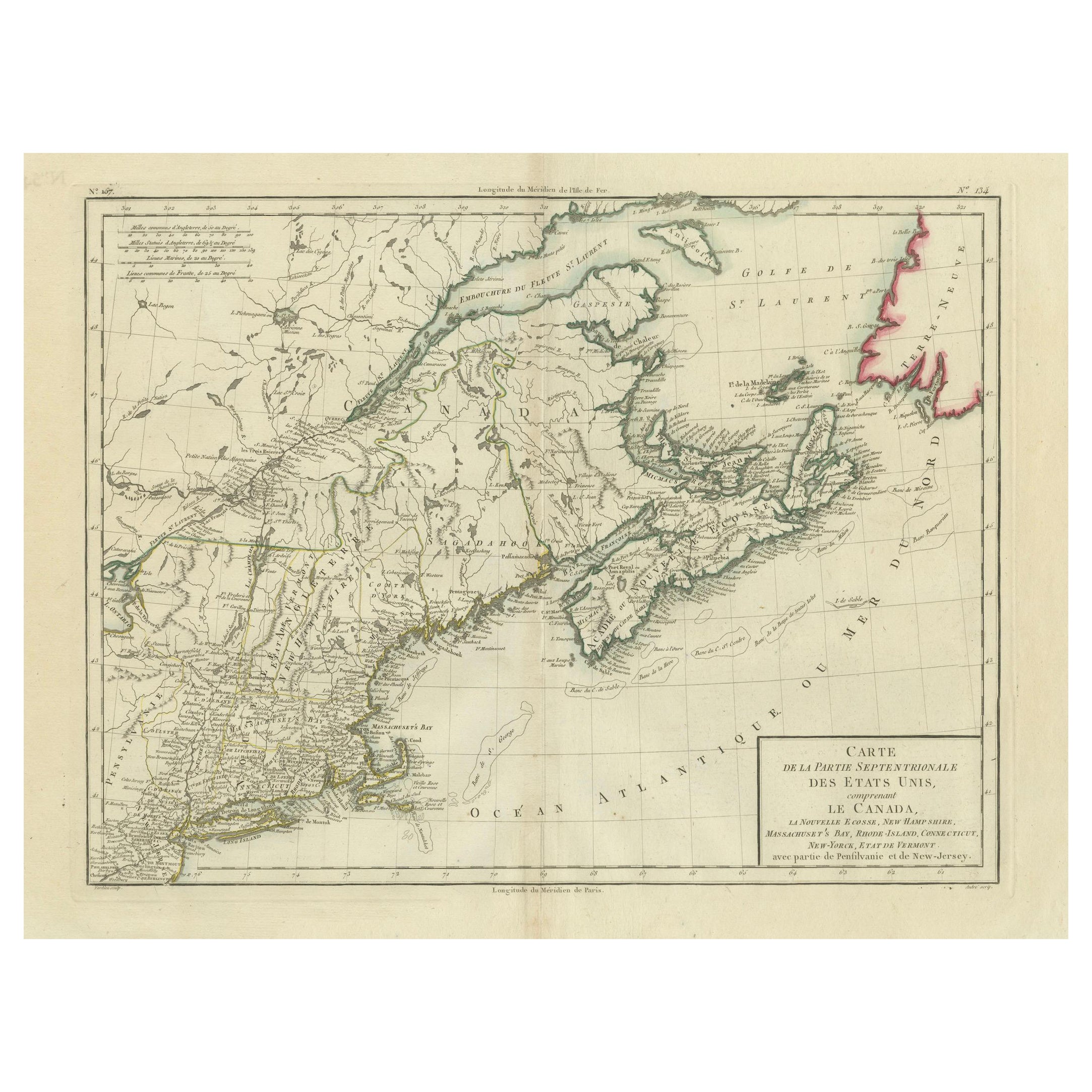
Antique Map of the Northeastern United States and Canada by Tardieu, 1802
Located in Langweer, NL
This antique map titled "Carte de la Partie Septentrionale des Etats Unis," created by Pierre Antoine Tardieu, depicts the northeastern part of the United States and parts of Canada....
Category
Antique Early 1800s Maps
Materials
Paper

$533 Sale Price
20% Off
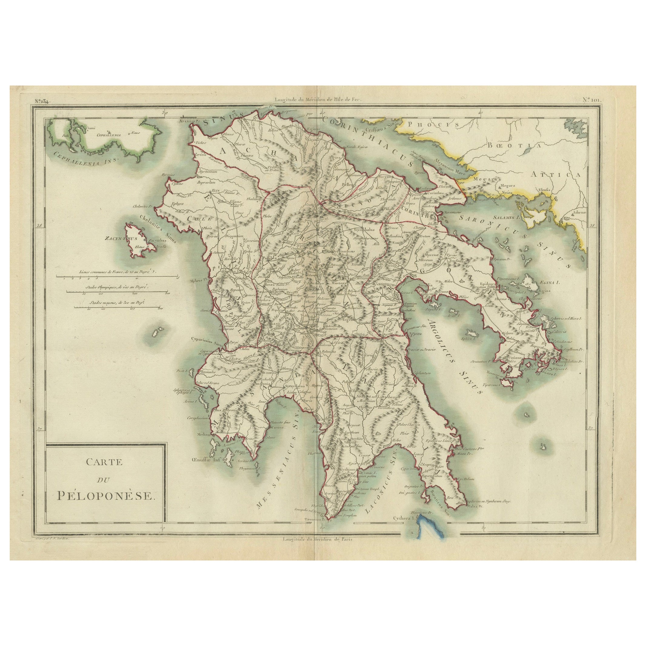
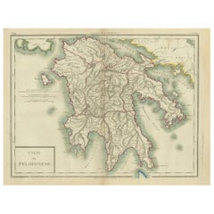
Antique Map of Peloponnesus, Greece by Pierre Antoine Tardieu, 1797
Located in Langweer, NL
This antique map, titled "Carte Ancienne d'Allemagne," represents ancient Germany and surrounding regions. It was published by the well-known Parisian mapmakers and publishers Jean-Baptiste-Louis Clouet and Alexandre Aimé Vuillemin in the late 18th century, specifically in 1787.
The map covers the extensive geographical area of ancient Germany, highlighting various tribes and regions known at the time. Key features include:
1. **Geographical Boundaries**: The map outlines the territorial extents of ancient Germany, bordered by Gallia (France) to the west, Sarmatia (parts of Eastern Europe) to the east, and the Italian regions to the south. The northern boundary reaches the Oceanus Germanicus (North Sea) and the Sarmatian Sea (Baltic Sea).
2. **Tribal Regions**: It details numerous ancient Germanic...
Category
Antique 1790s Maps
Materials
Paper
$323 Sale Price
20% Off
Antique Map of the United States by Lowry, '1852'
Located in Langweer, NL
Antique map titled 'United States'. Four individual sheets of the United States. This map originates from 'Lowry's Table Atlas constructed and engraved from the most recent Authoriti...
Category
Antique Mid-19th Century Maps
Materials
Paper

$285 Sale Price / set
20% Off
You May Also Like
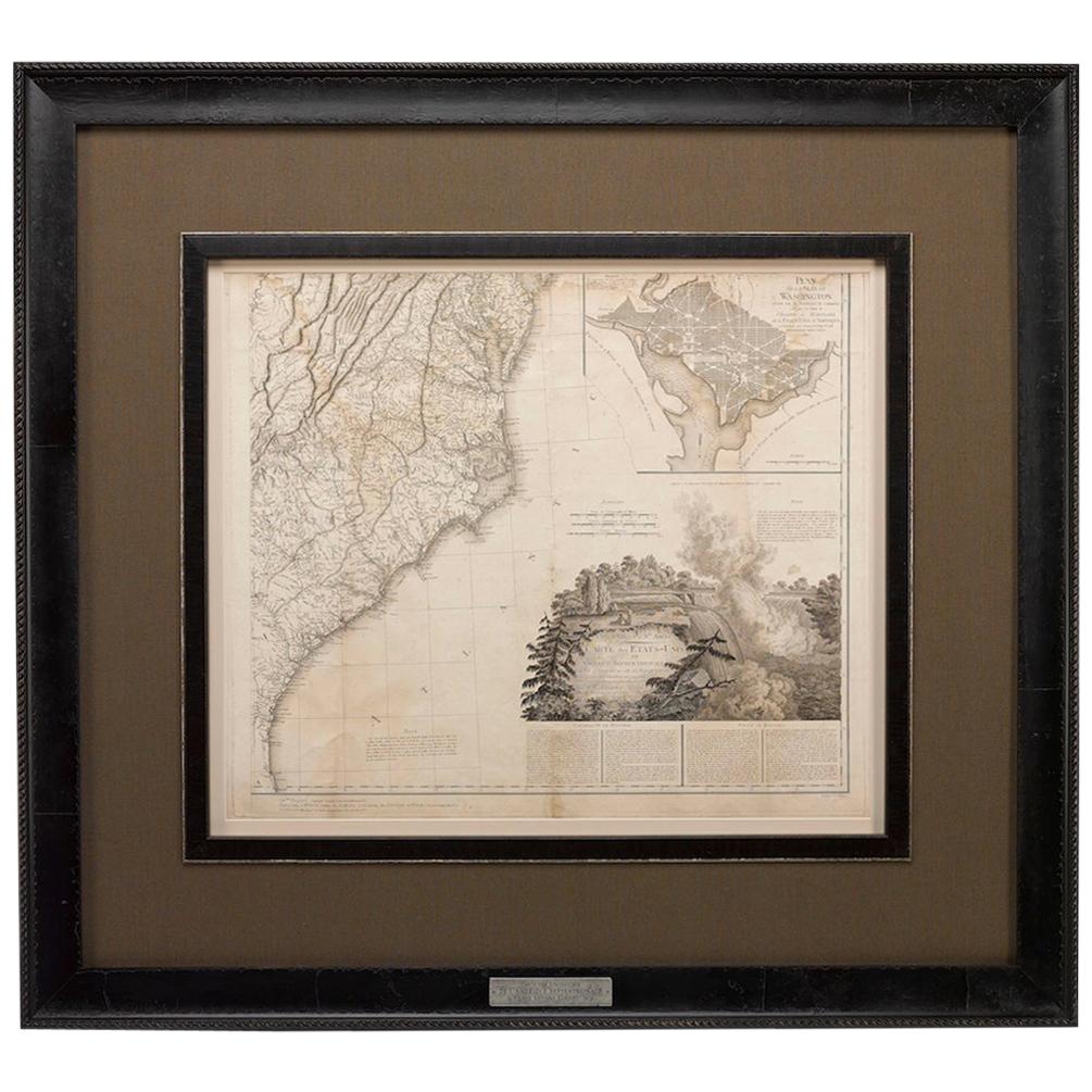
1812 United States Map, by Pierre Tardieu, Antique French Map Depicting the U.S.
By Pierre François Tardieu
Located in Colorado Springs, CO
1812 "United States of Nth America -- Carte des Etats-Unis De L'Amerique Septentrionale" Two-Sheet Map by Tardieu
This attractive map, published in Paris in 1812, is one of the most rare large format maps from the period. It features a view of the East Coast of the U.S. from Maryland to just below South Carolina. Additionally, Ellicott’s plan for the City of Washington D.C. is included at the top right and an illustration of Niagara Falls is shown at the bottom right with a description in both French and English. This extremely detailed map not only depicts the mountainous regions of the southeastern U.S., but also includes names of regions, rivers, and towns.
Based on the first state of Arrowsmith’s 4-sheet map of the United States, this map is completely engraved by Tardieu in Paris and showcases high quality engravings. This detailed map of the recently independent United States includes one of the largest and earliest examples of the Ellicott plan of Washington DC.
The artist, Pierre François Tardieu (PF Tardieu) was a very well-known map engraver, geographer, and illustrator. Awarded a bronze medal by King Louis-Phillipe for the accuracy and beauty of his map-making, Tardieu produced many fine works including maps of Louisiana...
Category
Antique 1810s French Maps
Materials
Paper

1859 "Map of the United States of America..." by J. H. Colton
By J.H. Colton
Located in Colorado Springs, CO
Presented is an 1859 “Map of the United States of America, the British Provinces, Mexico, the West Indies and Central America with Part of...
Category
Antique 1850s American Maps
Materials
Paper

Large Original Antique Map of the United States of America. 1891
By Rand McNally & Co.
Located in St Annes, Lancashire
Fabulous map of The United States
Original color
By Rand, McNally & Co.
Dated 1891
Unframed
Free shipping.
Category
Antique 1890s American Maps
Materials
Paper

Original Antique Map of The United States of America by Dower, circa 1835
Located in St Annes, Lancashire
Nice map of the USA
Drawn and engraved by J.Dower
Published by Orr & Smith. C.1835
Unframed.
Free shipping
Category
Antique 1830s English Maps
Materials
Paper

1847 Ornamental Map of the United States & Mexico by H. Phelps
Located in Colorado Springs, CO
Offered is an original 1847 ornamental map of the U.S. entitled "Ornamental Map of the United States & Mexico" by Humphrey Phelps. The map was issued as an act of Congress by Phelps on Fulton Street, New York. The broadside is elaborately hand-colored.
This is a very detailed and graphic propaganda map of the United States expressing U.S. dominance of the North American continent. The hand-colored map proclaims the Manifest Destiny, with the recent acquisition of Upper California and Texas at the conclusion of the Mexican-American War. The newly acquired land is boldly colored, standing in stark contrast to the rest of the U.S. The map details a potential route for a railroad running from New York City, to Buffalo, to Chicago, then west along the Oregon Trail to Oregon City. This route anticipates the construction of the transcontinental railroad by nearly 20 years.
The map includes elaborately detailed renderings of George Washington, Hernan Cortez, and Montezuma at top to represent European expansion to the Americas. At bottom are four inset designs with text showing the following: a chronological history of the U.S. beginning from settlement to the U.S. victory in the Mexican-American war; an illustration of General Zachary Taylor with details on the Oregon Territory; an illustration of the Aztec Temple of the Sun in Tenochtitlan and a chronology of the Conquest of the Aztec Empire under Cortez; a portrait of General Antonio Lopez de Santa Anna...
Category
Antique 1840s American Maps
Materials
Paper

1939 "A Good-Natured Map of the United States" by Greyhound
Located in Colorado Springs, CO
Presented is an original 1939 map, titled “A Good-Natured Map of the United States Setting Forth the Services of the Greyhound Lines and a Few Principal Connecting Bus Lines.” This brightly colored pictographic map was one of several similar United States maps...
Category
Vintage 1930s American Art Deco Maps
Materials
Paper
