Items Similar to Antique Map of England and Wales with Decorative Vignettes, 1851


Want more images or videos?
Request additional images or videos from the seller
1 of 6
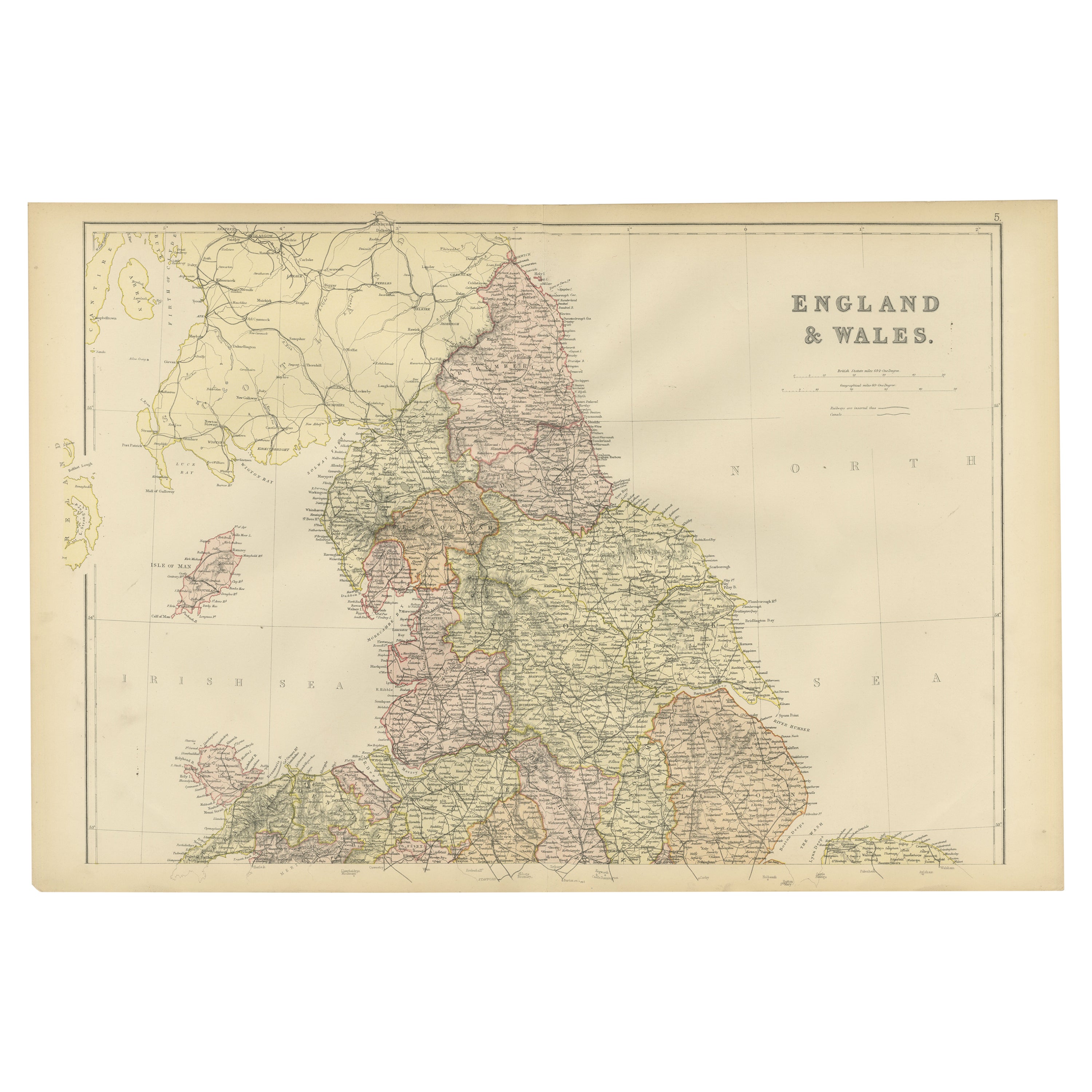
Antique Map of England and Wales with Decorative Vignettes, 1851
$431.19
$538.9820% Off
£319.53
£399.4220% Off
€360
€45020% Off
CA$588.65
CA$735.8120% Off
A$654.85
A$818.5620% Off
CHF 343.28
CHF 429.1020% Off
MX$8,002.11
MX$10,002.6420% Off
NOK 4,371.25
NOK 5,464.0720% Off
SEK 4,114.93
SEK 5,143.6620% Off
DKK 2,741.01
DKK 3,426.2620% Off
Shipping
Retrieving quote...The 1stDibs Promise:
Authenticity Guarantee,
Money-Back Guarantee,
24-Hour Cancellation
About the Item
Antique map titled ‘England and Wales’. Includes decorative vignettes titled The grand stand on the race ground Doncaster, London, Oxford, Entrance to Portsmouth Harbour, Sunderland Bridge and Newcastle-upon-Time. Originates from 'The Illustrated Atlas, And Modern History Of The World Geographical, Political, Commercial & Statistical, Edited By R. Montgomery Martin'. Published; John Tallis London, New York, Edinburgh & Dublin. 1851. Drawn and Engraved by J. Rapkin.
Artists and Engravers: John Tallis (1817-1876) was a British map publisher. Born in the Midlands, Tallis came to London in the 1840s. Tallis began his London career with a series of remarkable London street views. He began a partnership with a Frederick Tallis, possibly his brother, but their collaboration ended in 1849. For the Great Exhibition of 1851, Tallis published the Illustrated World Atlas, one of the last series of decorative world maps ever produced. The maps were engraved by John Rapkin, a skilled artisan. The maps were later reissued by the London Printing & Publishing Company, who left the Tallis imprint intact, thus ensuring his enduring fame. In 1858, he began publication of the popular Illustrated News of the World and National Portrait Gallery of Eminent Personages, selling it in 1861 (it ceased publication in 1863).
Condition: Very good. General age-related toning. Please study image carefully.
Date: 1851
Overall size: 26 x 37 cm.
Image size: 25 x 34 cm.
We sell original antique maps to collectors, historians, educators and interior decorators all over the world. Our collection includes a wide range of authentic antique maps from the 16th to the 20th centuries. Buying and collecting antique maps is a tradition that goes back hundreds of years. Antique maps have proved a richly rewarding investment over the past decade, thanks to a growing appreciation of their unique historical appeal. Today the decorative qualities of antique maps are widely recognized by interior designers who appreciate their beauty and design flexibility. Depending on the individual map, presentation, and context, a rare or antique map can be modern, traditional, abstract, figurative, serious or whimsical. We offer a wide range of authentic antique maps for any budget.
- Dimensions:Height: 14.57 in (37 cm)Width: 10.24 in (26 cm)Depth: 0 in (0.01 mm)
- Materials and Techniques:
- Period:
- Date of Manufacture:1851
- Condition:
- Seller Location:Langweer, NL
- Reference Number:Seller: BG-027431stDibs: LU3054326247402
About the Seller
5.0
Recognized Seller
These prestigious sellers are industry leaders and represent the highest echelon for item quality and design.
Platinum Seller
Premium sellers with a 4.7+ rating and 24-hour response times
Established in 2009
1stDibs seller since 2017
2,502 sales on 1stDibs
Typical response time: <1 hour
- ShippingRetrieving quote...Shipping from: Langweer, Netherlands
- Return Policy
Authenticity Guarantee
In the unlikely event there’s an issue with an item’s authenticity, contact us within 1 year for a full refund. DetailsMoney-Back Guarantee
If your item is not as described, is damaged in transit, or does not arrive, contact us within 7 days for a full refund. Details24-Hour Cancellation
You have a 24-hour grace period in which to reconsider your purchase, with no questions asked.Vetted Professional Sellers
Our world-class sellers must adhere to strict standards for service and quality, maintaining the integrity of our listings.Price-Match Guarantee
If you find that a seller listed the same item for a lower price elsewhere, we’ll match it.Trusted Global Delivery
Our best-in-class carrier network provides specialized shipping options worldwide, including custom delivery.More From This Seller
View AllAntique Map of England and Wales by Johnson '1872'
Located in Langweer, NL
Antique map titled 'Johnson's England and Wales'. Original map of England and Wales. This map originates from 'Johnson's New Illustrated Family Atlas of the World' by A.J. Johnson. P...
Category
Antique Late 19th Century Maps
Materials
Paper

$239 Sale Price
20% Off
Antique Map of England & Wales by Wyld '1845'
Located in Langweer, NL
Antique map titled 'England & Wales'. Original antique map of England & Wales. This map originates from 'An Atlas of the World, Comprehending Se...
Category
Antique Mid-19th Century Maps
Materials
Paper

$135 Sale Price
24% Off
Antique Map of England and Wales 'North' by A.K. Johnston, 1865
Located in Langweer, NL
Antique map titled 'England and Wales (Northern Sheet)'. This map originates from the ‘Royal Atlas of Modern Geography’ by Alexander Keith Johnston. Published by William Blackwood an...
Category
Antique Mid-19th Century Maps
Materials
Paper

$263 Sale Price
20% Off
Antique Map of England and Wales by A.K. Johnston, 1865
Located in Langweer, NL
Antique map titled 'England and Wales (Southern Sheet)'. With an inset map of the Scilly Islands. This map originates from the ‘Royal Atlas of Modern Geography’ by Alexander Keith Jo...
Category
Antique Mid-19th Century Maps
Materials
Paper

$263 Sale Price
20% Off
Antique Map of, Northern England and Wales by Johnston, 1882
Located in Langweer, NL
Antique map titled 'England and Wales'.
Old map of England and Wales. This map originates from 'The Royal Atlas of Modern Geography, Exhibiting, in a Series of Entirely Original an...
Category
Antique 19th Century Maps
Materials
Paper

Colorful Detailed Antique Map of England and Wales, 1882
Located in Langweer, NL
Explore the Historic Splendor of 'England and Wales' with this Antique Map! Part of a distinguished collection, this map presents a captivating view of the enchanting landscapes, cit...
Category
Antique 1880s Maps
Materials
Paper
$162 Sale Price
20% Off
You May Also Like
Large Original Vintage Map of the United Kingdom, circa 1920
Located in St Annes, Lancashire
Great map of The United Kingdom
Unframed
Original color
By John Bartholomew and Co. Edinburgh Geographical Institute
Published, circa 1920
Free shipping.
Category
Vintage 1920s British Maps
Materials
Paper

England and Wales, Northern Part. Century Atlas antique vintage map
Located in Melbourne, Victoria
'The Century Atlas. England and Wales, Northern Part'
Original antique map, 1903.
Central fold as issued. Map name and number printed on the reverse corners.
Sheet 29.5cm by 40cm.
Category
Early 20th Century Victorian More Prints
Materials
Lithograph

Antique County Map, Lancashire, English, Framed Lithography, Cartography, C.1860
Located in Hele, Devon, GB
This is an antique lithography map of Lancashire. An English, framed atlas engraving of cartographic interest, dating to the mid 19th century and later.
Superb lithography of Lanca...
Category
Antique Mid-19th Century British Victorian Maps
Materials
Glass, Wood, Paper

Antique West Yorkshire Map, English, Framed Lithography, Cartography, Victorian
Located in Hele, Devon, GB
This is an antique lithography map of West Yorkshire. An English, framed atlas engraving of cartographic interest, dating to the mid 19th century and later.
Superb lithography of t...
Category
Antique Mid-19th Century British Victorian Maps
Materials
Paper

Antique County Map, Berkshire, English Framed Lithograph, Cartography, Victorian
Located in Hele, Devon, GB
This is an antique lithography map of Berkshire. An English, framed atlas engraving of cartographic interest, dating to the mid 19th century and later.
Superb lithography of Berksh...
Category
Antique Mid-19th Century British Victorian Maps
Materials
Paper

Antique Lithography Map, Derbyshire, English, Framed Cartography, Victorian
Located in Hele, Devon, GB
This is an antique lithography map of Derbyshire. An English, framed atlas engraving of cartographic interest, dating to the mid 19th century and later.
Superb lithography of Derby...
Category
Antique Mid-19th Century British Victorian Maps
Materials
Glass, Wood, Paper

More Ways To Browse
Wales And Wales Furniture
16th Century England
Antique And Artisan Gallery
Used Furniture Portsmouth
Antique Sunderland
Antique Maps Dublin
Medieval Capital
Civil War Map
Map Of Singapore
Migeon Migeon
Scottish Coat Of Arms
Antique Maps Of Canada
Antique Railroad Maps
Relief Map
Antique Map Of Venice
Antique Map Of Georgia
Antique Nautical Charts
Hand Painted Antique Map