Items Similar to Antique Map of the Famous French Wine Area of Correze, 1854

Want more images or videos?
Request additional images or videos from the seller
1 of 5
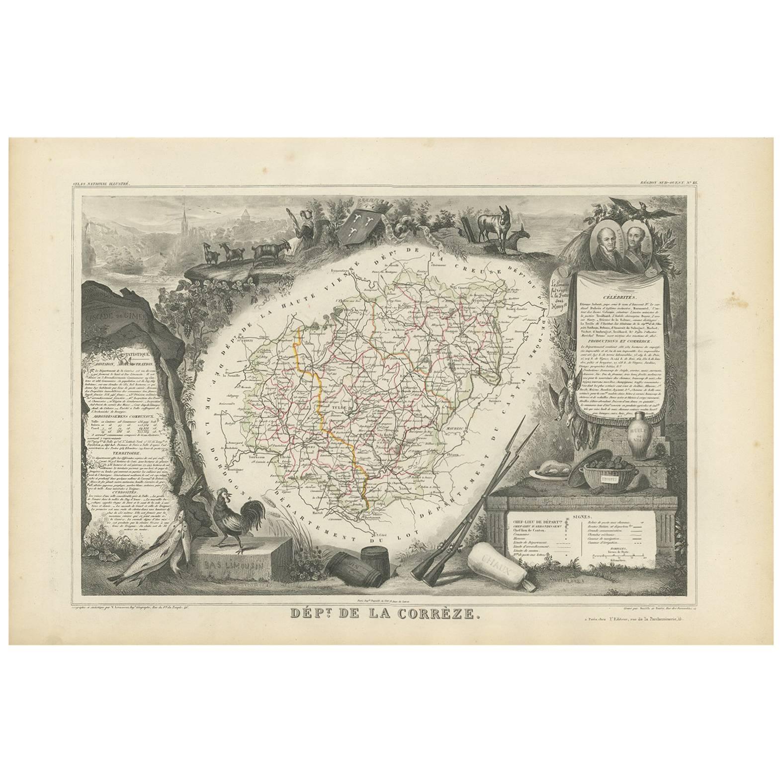
Antique Map of the Famous French Wine Area of Correze, 1854
$111.86
$139.8220% Off
£84.36
£105.4520% Off
€96
€12020% Off
CA$154.65
CA$193.3220% Off
A$173.24
A$216.5520% Off
CHF 90.99
CHF 113.7420% Off
MX$2,106.53
MX$2,633.1620% Off
NOK 1,152.25
NOK 1,440.3120% Off
SEK 1,093.79
SEK 1,367.2420% Off
DKK 730.81
DKK 913.5220% Off
About the Item
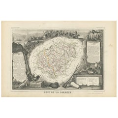
Antique map titled 'Dépt. da la Corrèze'. Map of the French department of Correze, France. This area of France is known for its production of straw wine, a sweet red or white wine. The whole is surrounded by elaborate decorative engravings designed to illustrate both the natural beauty and trade richness of the land. There is a short textual history of the regions depicted on both the left and right sides of the map. This map originates from ‘Atlas National de la France Illustré’ by V. Levasseur.
Arists and Engravers: Published by A. Combette, Paris, 1854.
Condition: Good, general age-related toning. Few small tears, please study image carefully.
Date: 1854
Overall size: 53 x 36 cm.
Image size: 42.5 x 29.5 cm.
We sell original antique maps to collectors, historians, educators and interior decorators all over the world. Our collection includes a wide range of authentic antique maps from the 16th to the 20th centuries. Buying and collecting antique maps is a tradition that goes back hundreds of years. Antique maps have proved a richly rewarding investment over the past decade, thanks to a growing appreciation of their unique historical appeal. Today the decorative qualities of antique maps are widely recognized by interior designers who appreciate their beauty and design flexibility. Depending on the individual map, presentation, and context, a rare or antique map can be modern, traditional, abstract, figurative, serious or whimsical. We offer a wide range of authentic antique maps for any budget.
- Dimensions:Height: 14.18 in (36 cm)Width: 20.87 in (53 cm)Depth: 0 in (0.01 mm)
- Materials and Techniques:
- Period:
- Date of Manufacture:1854
- Condition:
- Seller Location:Langweer, NL
- Reference Number:Seller: BG-005341stDibs: LU3054326145902
About the Seller
5.0
Recognized Seller
These prestigious sellers are industry leaders and represent the highest echelon for item quality and design.
Platinum Seller
Premium sellers with a 4.7+ rating and 24-hour response times
Established in 2009
1stDibs seller since 2017
2,517 sales on 1stDibs
Typical response time: <1 hour
- ShippingRetrieving quote...Shipping from: Langweer, Netherlands
- Return Policy
Authenticity Guarantee
In the unlikely event there’s an issue with an item’s authenticity, contact us within 1 year for a full refund. DetailsMoney-Back Guarantee
If your item is not as described, is damaged in transit, or does not arrive, contact us within 7 days for a full refund. Details24-Hour Cancellation
You have a 24-hour grace period in which to reconsider your purchase, with no questions asked.Vetted Professional Sellers
Our world-class sellers must adhere to strict standards for service and quality, maintaining the integrity of our listings.Price-Match Guarantee
If you find that a seller listed the same item for a lower price elsewhere, we’ll match it.Trusted Global Delivery
Our best-in-class carrier network provides specialized shipping options worldwide, including custom delivery.More From This Seller
View AllAntique Map of Corrèze ‘France’ by V. Levasseur, 1854
By Victor Levasseur
Located in Langweer, NL
Antique map titled 'Dépt. da la Corrèze'. Map of the French department of Correze, France. This area of France is known for its production of Straw Wine, a sweet red or white wine. T...
Category
Antique Mid-19th Century Maps
Materials
Paper
$167 Sale Price
20% Off
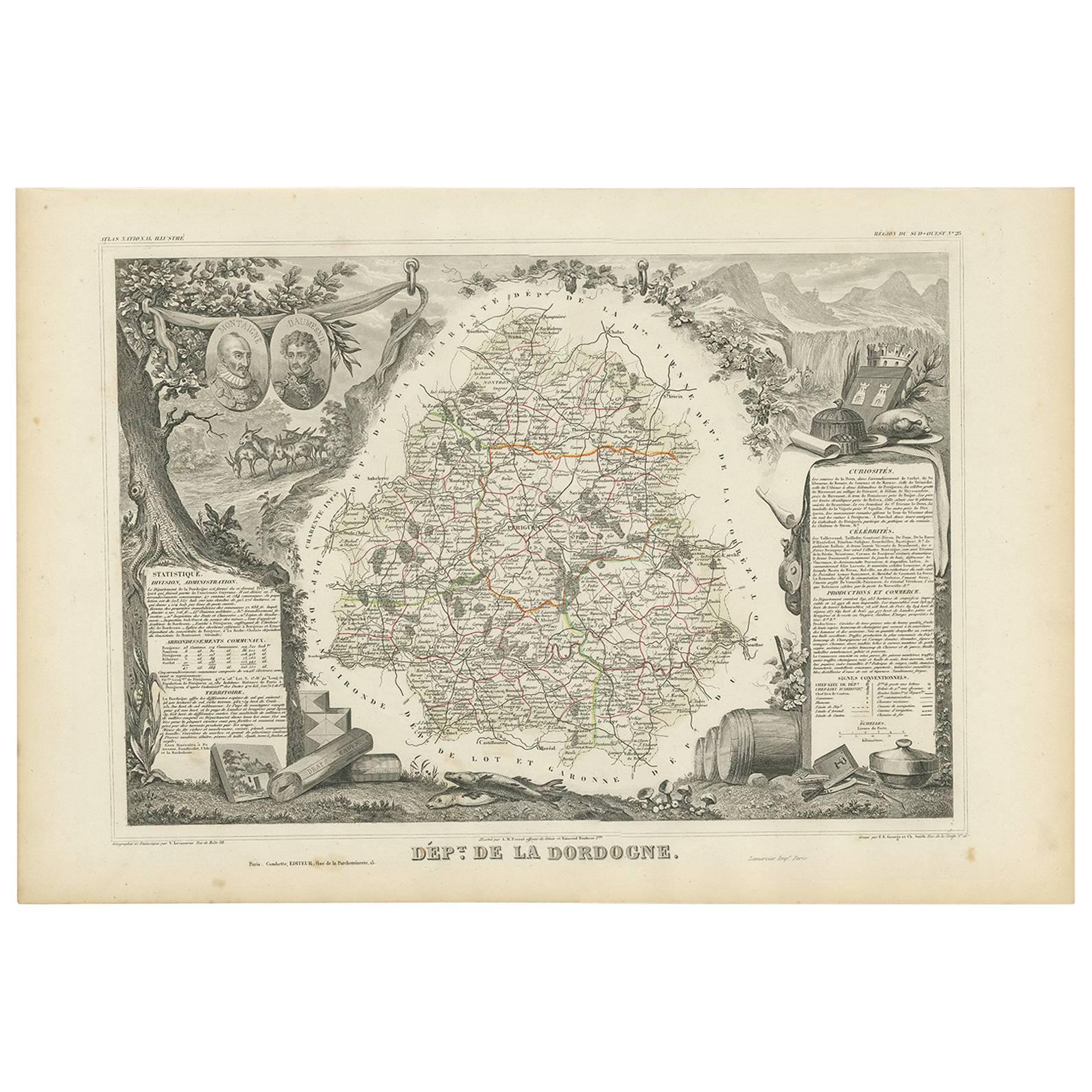
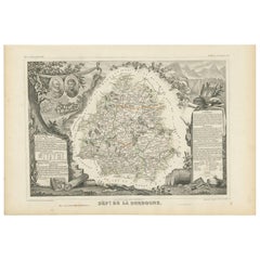
Antique Map of the Dordogne ‘France’ by V. Levasseur, 1854
Located in Langweer, NL
Antique map titled 'Dépt. de la Dordogne'. Map of the French department of Dordogne, France. This area is best known for its production of Monbazillac, a sweet white wine, and Cabéco...
Category
Antique Mid-19th Century Maps
Materials
Paper
$186 Sale Price
20% Off
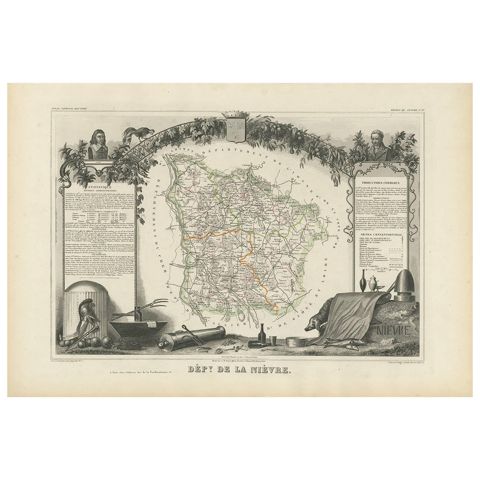
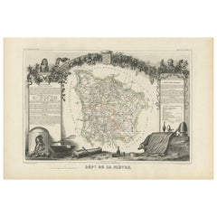
Antique Map of Nièvre ‘France’ by V. Levasseur, 1854
Located in Langweer, NL
Antique map titled 'Dépt. de la Nièvre'. Map of the French department of Nievre, France. Part of the prestiegous Burgundy or Bourgogne wine region this area is known for its producti...
Category
Antique Mid-19th Century Maps
Materials
Paper
$167 Sale Price
20% Off
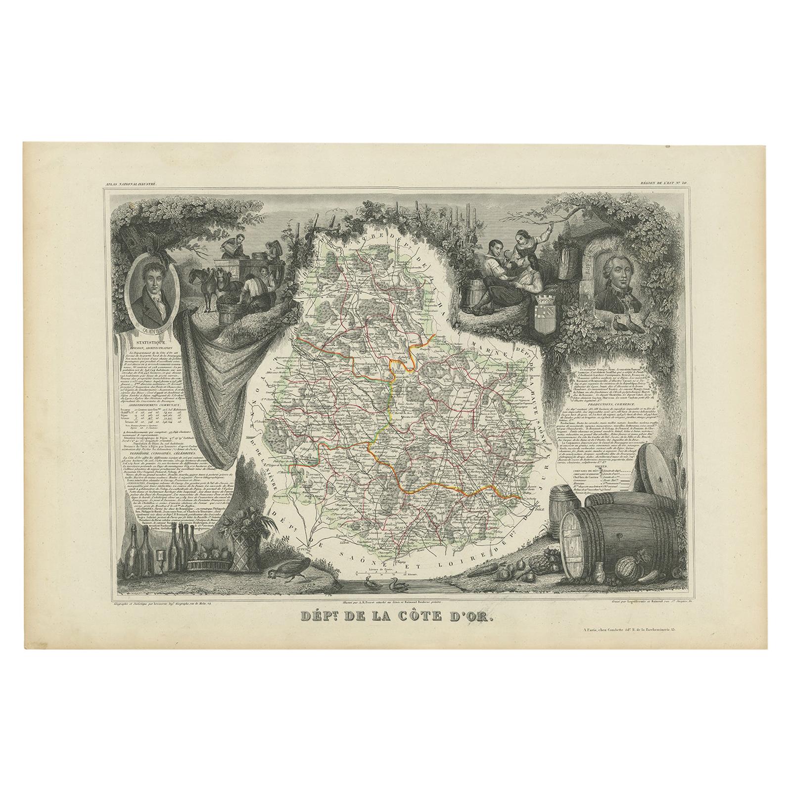
Antique Map of Côte d'Or ‘France’ by V. Levasseur, 1854
By Victor Levasseur
Located in Langweer, NL
Antique map titled 'Dépt. de la Côte d'Or'. Map of the French department of Cote D’Or, France. Part of France's Burgundy or Bourgogne wine region, a premier wine-growing region of Fr...
Category
Antique Mid-19th Century Maps
Materials
Paper
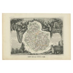
$139 Sale Price
20% Off
Antique Map of Loire ‘France’ by V. Levasseur, 1854
Located in Langweer, NL
Antique map titled 'Dépt. de la Loire'. Map of the French department of Loire, France. This area of France is part of the Loire Valley wine growing region. The area includes 87 appel...
Category
Antique Mid-19th Century Maps
Materials
Paper
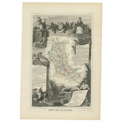
$139 Sale Price
20% Off
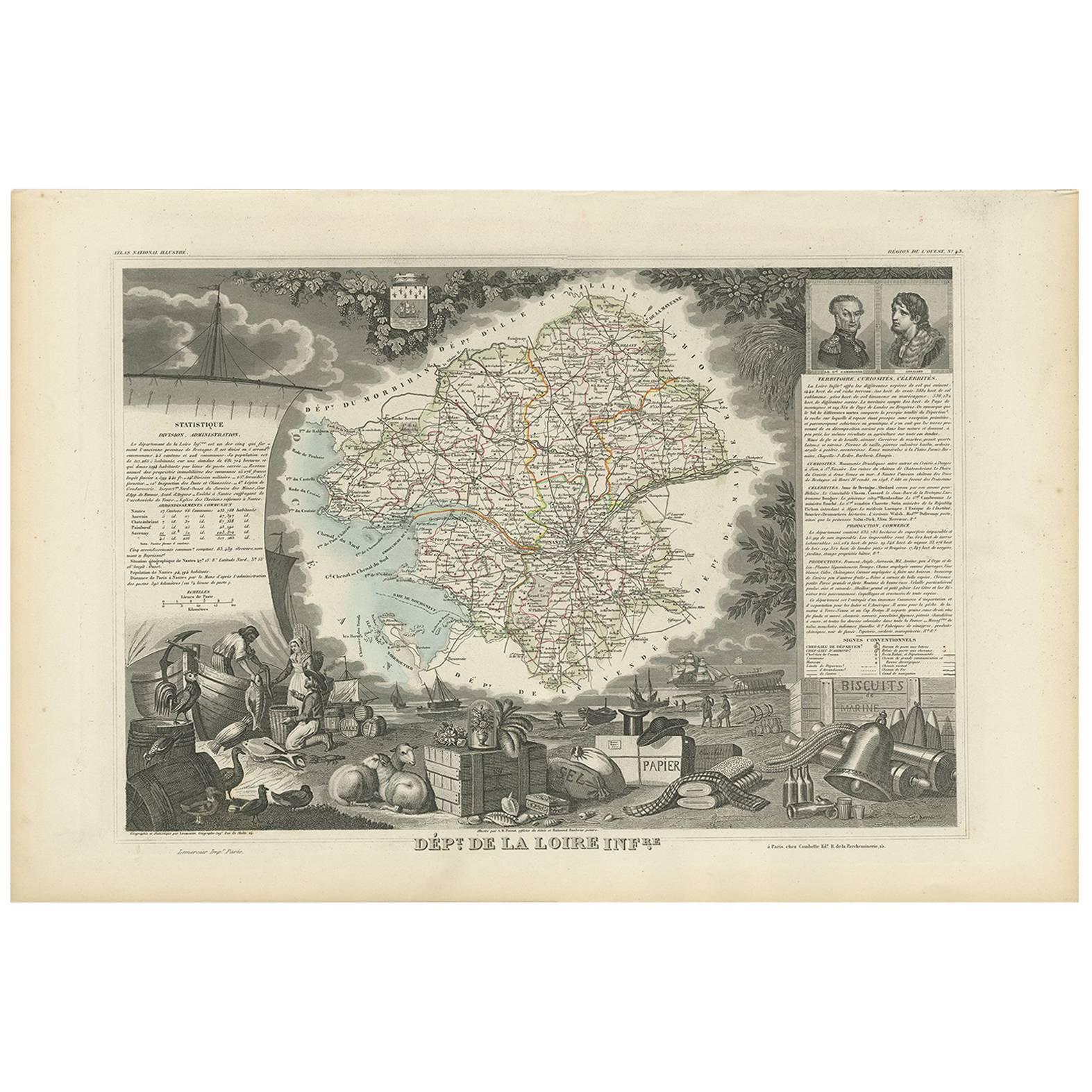
Antique Map of Loire Inferieure ‘France’ by V. Levasseur, 1854
Located in Langweer, NL
Antique map titled 'Dépt. de la Loire Inferieure'. Map of the French department of Loire Inferieure, France (currently known as Loire-Atlantique.) This area of France is part of the ...
Category
Antique Mid-19th Century Maps
Materials
Paper
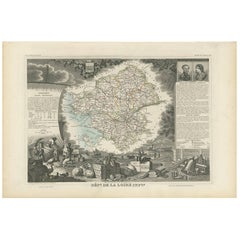
$186 Sale Price
20% Off
You May Also Like
L'Isere, France. Antique map of French department, 1856
By Victor Levasseur
Located in Melbourne, Victoria
'Dept. de L'Isere', Steel engraving with original outline hand-colouring., 1856, from Levasseur's 'Atlas National Illustre'.
This area is known for its production of Bleu du Vercor...
Category
19th Century Naturalistic Landscape Prints
Materials
Engraving

Saone and Loire, France. Antique map of a French department, 1856
By Victor Levasseur
Located in Melbourne, Victoria
'Dept. de Saone et Loire', steel engraving with original outline hand-colouring., 1856, from Levasseur's Atlas National Illustre.
The French department of Saone et Loire is at the ...
Category
19th Century Naturalistic Landscape Prints
Materials
Engraving

Aude, France. Antique map of a French department, 1856
By Victor Levasseur
Located in Melbourne, Victoria
'Dept. de L' Aude', steel engraving with original outline hand-colouring., 1856, from Levasseur's 'Atlas National Illustre'.
This area of France is famous for its wide variety of v...
Category
19th Century Naturalistic Landscape Prints
Materials
Engraving

Aube, France. Antique map of a French department, 1856
By Victor Levasseur
Located in Melbourne, Victoria
'Dept. de L'Aube', steel engraving with original outline hand-colouring., 1856, from Levasseur's 'Atlas National Illustre'.
This area of France is known for its production of Chaou...
Category
19th Century Naturalistic Landscape Prints
Materials
Engraving

Lozere, France. Antique map of a French department, 1856
By Victor Levasseur
Located in Melbourne, Victoria
'Dept. de La Lozere', steel engraving with original outline hand-colouring., 1856, from Levasseur's 'Atlas National Illustre'.
This remote mountainous part of Languedoc is rural, s...
Category
19th Century Naturalistic Landscape Prints
Materials
Engraving

Jura, France. Antique map of a French department, 1856
By Victor Levasseur
Located in Melbourne, Victoria
'Dept. du Jura', steel engraving with original outline hand-colouring., 1856, from Levasseur's 'Atlas National Illustre'.
The Jura wines are very distinctive and unusual, such as V...
Category
19th Century Naturalistic Landscape Prints
Materials
Engraving

More Ways To Browse
French Wine Map
Joan Blaeu
Antique Nautical Maps
Antique Portuguese Plates
New Zealand Map
Antique Railroad Collectibles
Blaeu World Map
Roman Empire Map
Antique Map Of Middle East
Caribbean Map
Antique Map Of Egypt
Antique Map Ortelius
Antique Farm Antiques Collectibles
Antique Galleon
Biblical Maps
Medieval Capital
Civil War Map
Map Of Singapore