Items Similar to Antique Map of the French Coast at Boulogne and Picardy
Want more images or videos?
Request additional images or videos from the seller
1 of 6
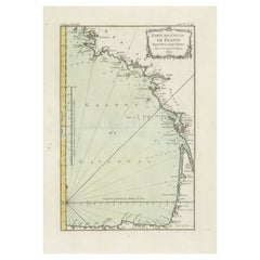
Antique Map of the French Coast at Boulogne and Picardy
$469.67
$587.0920% Off
£349.64
£437.0520% Off
€392
€49020% Off
CA$643.33
CA$804.1720% Off
A$715.53
A$894.4120% Off
CHF 373.63
CHF 467.0320% Off
MX$8,707.21
MX$10,884.0120% Off
NOK 4,771.78
NOK 5,964.7220% Off
SEK 4,475.08
SEK 5,593.8620% Off
DKK 2,984.16
DKK 3,730.2020% Off
Shipping
Retrieving quote...The 1stDibs Promise:
Authenticity Guarantee,
Money-Back Guarantee,
24-Hour Cancellation
About the Item
Antique map titled 'Les Costes du Boulenois et de la Picardie'. Map of the French coast at Boulogne and Picardy. Left a large wind rose. Part of a bundled collection of plans of battles and cities renowned in the Spanish succession war. Engraved by J. Harrewijn, published 1712.
- Dimensions:Height: 20.95 in (53.2 cm)Width: 24.26 in (61.6 cm)Depth: 0.02 in (0.5 mm)
- Materials and Techniques:
- Period:
- Date of Manufacture:1712
- Condition:General age-related toning. Original folding line, with small split. Minor wear and soiling. Blank verso. Please study image carefully.
- Seller Location:Langweer, NL
- Reference Number:Seller: BG-13530-21stDibs: LU3054336106462
About the Seller
5.0
Recognized Seller
These prestigious sellers are industry leaders and represent the highest echelon for item quality and design.
Platinum Seller
Premium sellers with a 4.7+ rating and 24-hour response times
Established in 2009
1stDibs seller since 2017
2,510 sales on 1stDibs
Typical response time: <1 hour
- ShippingRetrieving quote...Shipping from: Langweer, Netherlands
- Return Policy
Authenticity Guarantee
In the unlikely event there’s an issue with an item’s authenticity, contact us within 1 year for a full refund. DetailsMoney-Back Guarantee
If your item is not as described, is damaged in transit, or does not arrive, contact us within 7 days for a full refund. Details24-Hour Cancellation
You have a 24-hour grace period in which to reconsider your purchase, with no questions asked.Vetted Professional Sellers
Our world-class sellers must adhere to strict standards for service and quality, maintaining the integrity of our listings.Price-Match Guarantee
If you find that a seller listed the same item for a lower price elsewhere, we’ll match it.Trusted Global Delivery
Our best-in-class carrier network provides specialized shipping options worldwide, including custom delivery.More From This Seller
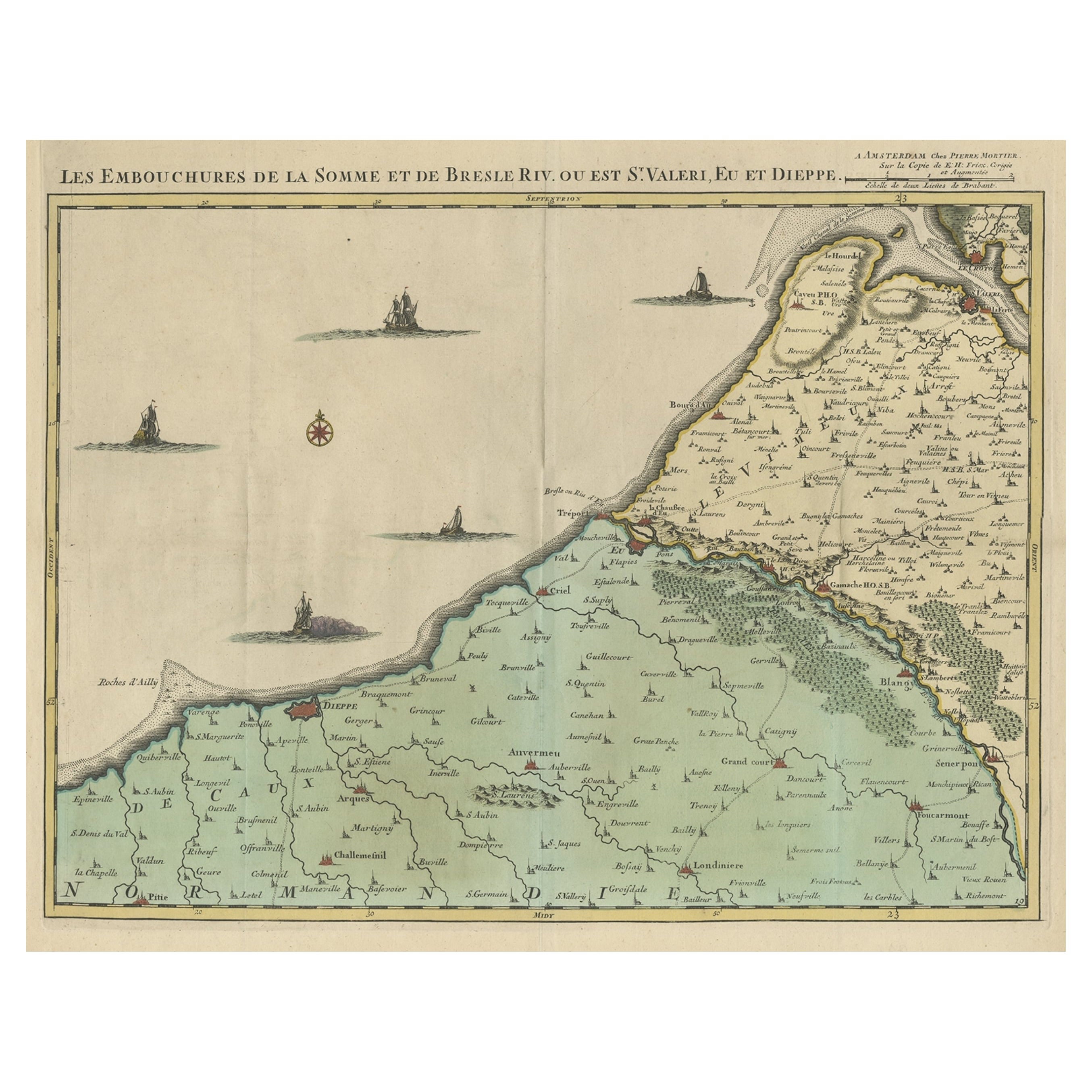
View AllBeautiful Antique Map of the French Coast, from St. Valeri to Dieppe, 1720
Located in Langweer, NL
Antique map France titled 'Les Embouchures de la Somme et de Bresle Riv. ou est St. Valeri, Eu et Dieppe'.
Beautiful map of the French coast, fr...
Category
Antique 1720s Maps
Materials
Paper

$856 Sale Price
35% Off
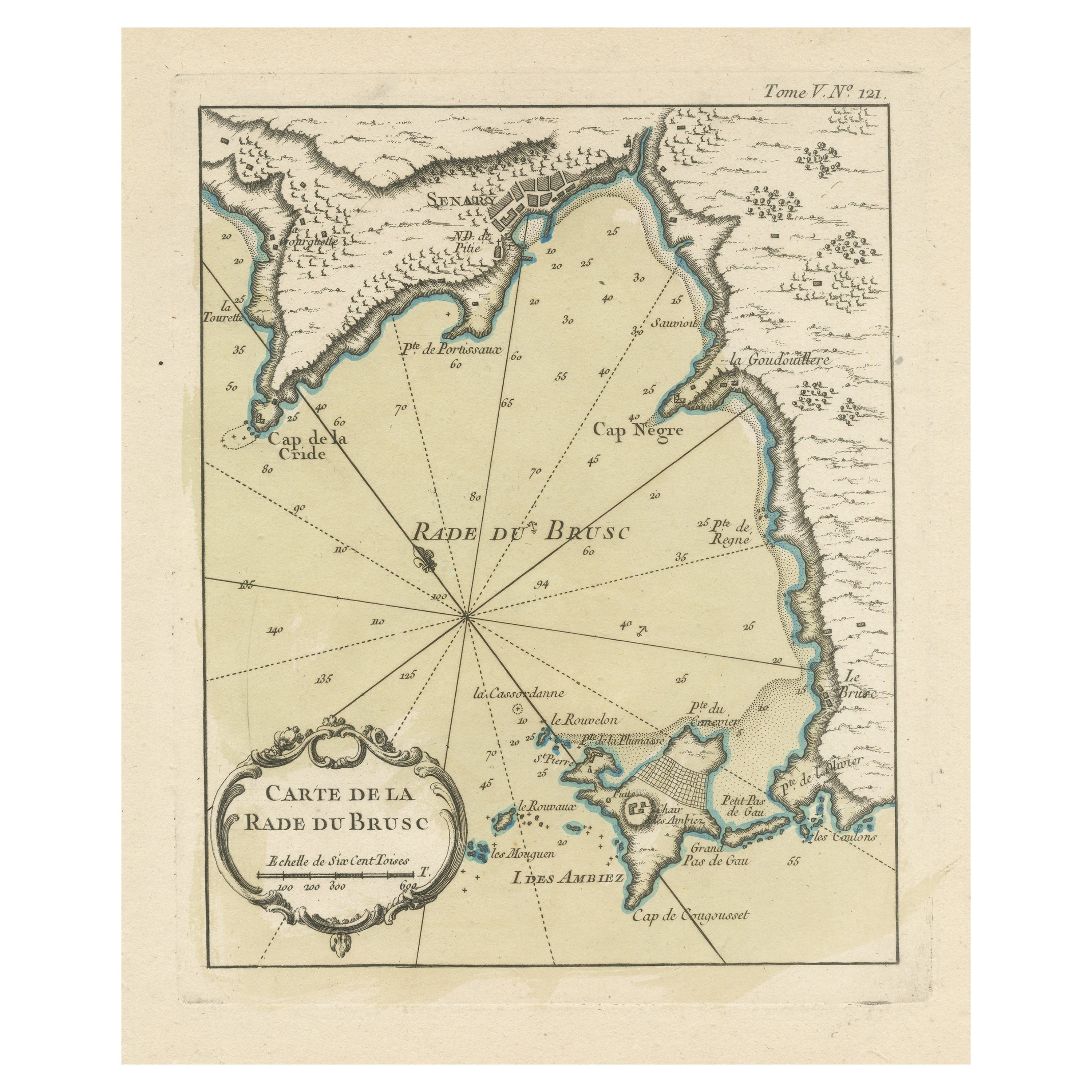
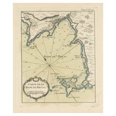
Antique Map of the Bay of Brusc, France
Located in Langweer, NL
Antique map titled 'Carte de la rade du Brusc'. Original map of the bay of Brusc, France. This map originates from 'Le Petit Atlas Maritime (..)' by J.N. Bellin. Published 1764.
...
Category
Antique Mid-18th Century Maps
Materials
Paper
$325 Sale Price
20% Off
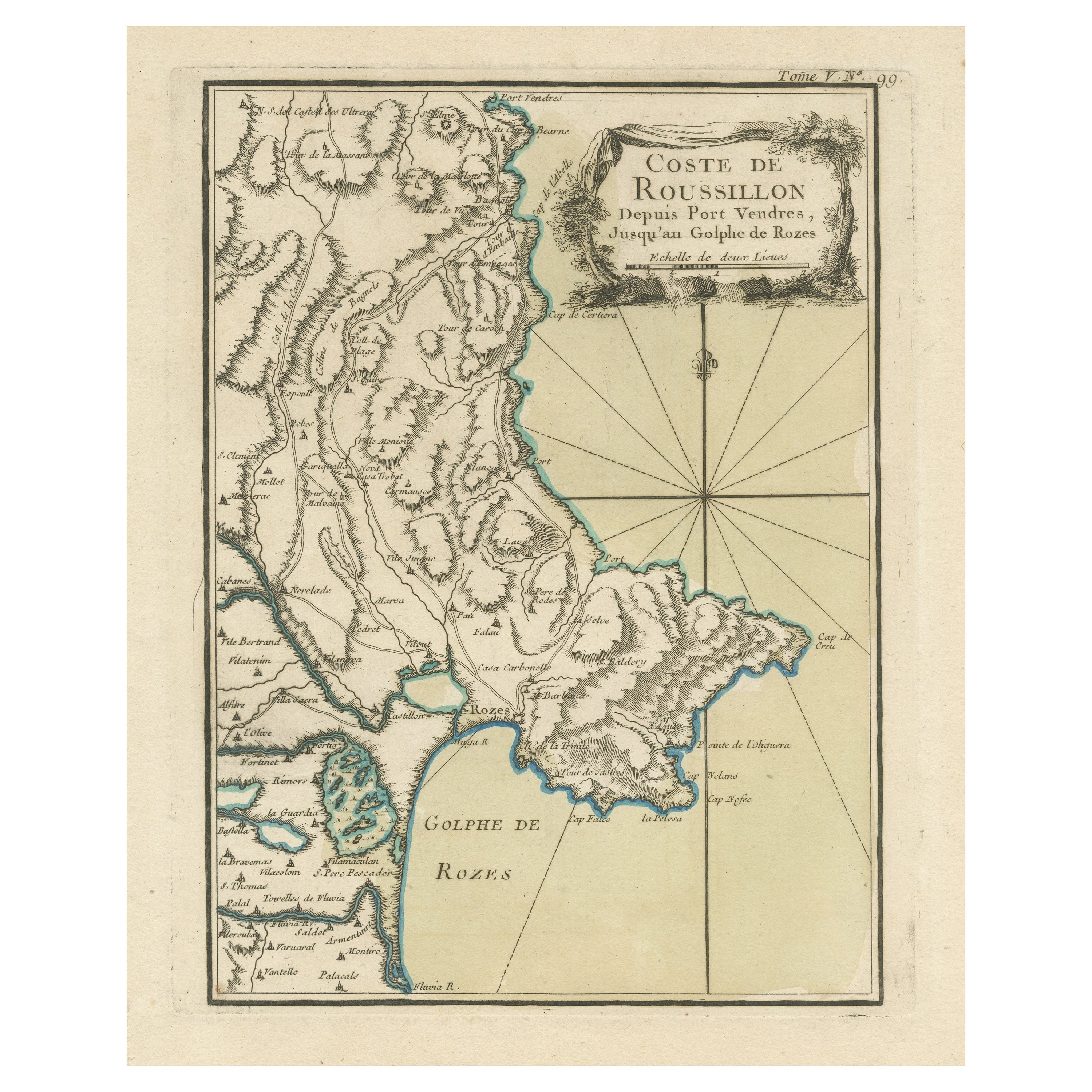
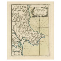
Antique Map of the Coast of Roussillon, France
Located in Langweer, NL
Antique map titled 'Coste de Roussillon depuis Port Vendres, jusqu'au golphe de Rozes'. Original map of the coast of Roussillon, France. This map originates from 'Le Petit Atlas Mari...
Category
Antique Mid-18th Century Maps
Materials
Paper
$325 Sale Price
20% Off
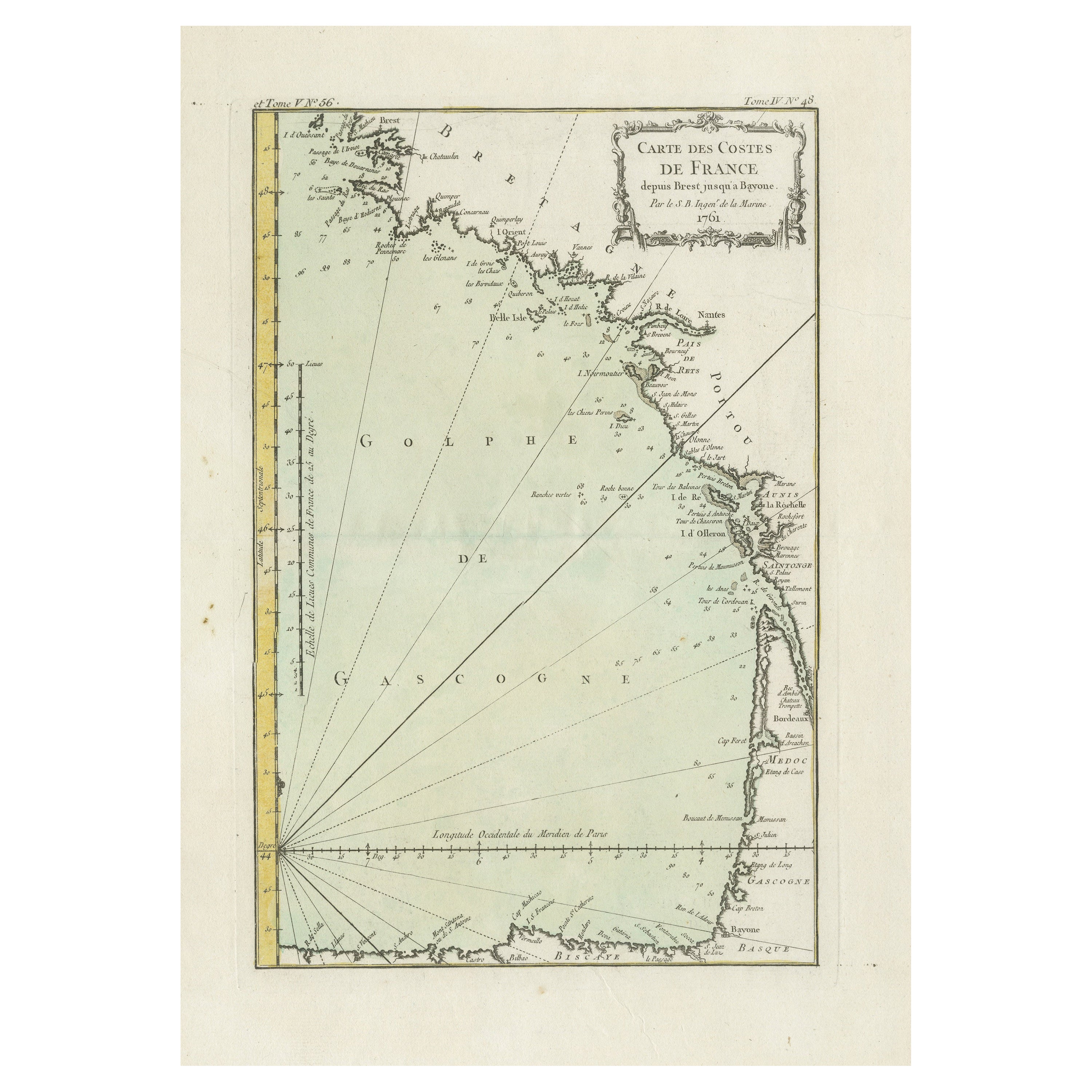
Antique Map of the Coast of France Between Brest and Bayonne
Located in Langweer, NL
Antique map titled 'Carte des Costes de France depuis Brest jusquá Bayone'. Original old map of the coast of France between Brest and Bayonne. This map originates from 'Le Petit Atla...
Category
Antique Mid-18th Century Maps
Materials
Paper
$306 Sale Price
20% Off
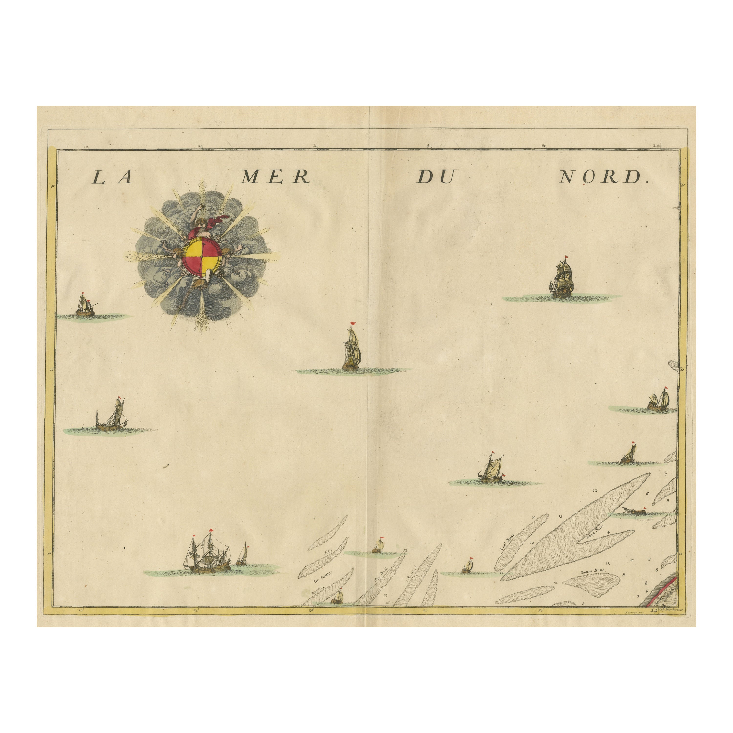
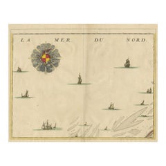
Antique Map of the North Sea and Dunkirk
Located in Langweer, NL
Untitled map of the North Sea, top left a large compass rose, bottom right Dunkirk (Duinkerke / Dunkerque), France. Part of a bundled collection of plans of battles and cities renown...
Category
Antique Early 18th Century Maps
Materials
Paper
$421 Sale Price
20% Off
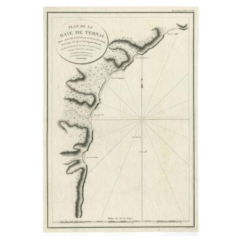
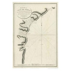
Antique Map of the Bay of Terney by La Pérouse, 1797
Located in Langweer, NL
Antique map titled 'Plan de la Baie de Ternai'. Old map of the north eastern coast of Russia. This map originates from 'Atlas du voyage de La Perouse'. Arti...
Category
Antique 18th Century Maps
Materials
Paper
$146 Sale Price
20% Off
You May Also Like
The Normandy Region of France: A 17th C. Hand-colored Map by Sanson and Jaillot
By Nicolas Sanson
Located in Alamo, CA
This large hand-colored map entitled "Le Duché et Gouvernement de Normandie divisée en Haute et Basse Normandie en divers Pays; et par evêchez, avec le Gouvernement General du Havre ...
Category
Antique 1690s French Maps
Materials
Paper

1771 Bonne Map of Poitou, Touraine and Anjou, France, Ric.a015
Located in Norton, MA
1771 Bonne Map of Poitou,
Touraine and Anjou, France
Ric.a015
1771 Bonne map of Potiou, Touraine and Anjou entitled "Carte des Gouvernements D'Anjou et du Saumurois, de la Touraine, du Poitou,du Pays d'aunis, Saintonge?Angoumois,"
Carte des gouvernements d'Anjou et du Saumurois, de la Touraine, du Poitou, du Pays d'Aunis, Saintonge-Angoumois. Projettee et assujettie au ciel par M. Bonne, Hyd. du Roi. A Paris, Chez Lattre, rue St. Jacques a la Ville de Bord(ea)ux. Avec priv. du Roi. 1771. Arrivet inv. & sculp., Atlas moderne ou collection de cartes sur toutes...
Category
Antique 17th Century Unknown Maps
Materials
Paper

Large 19th Century Map of France
Located in Pease pottage, West Sussex
Large 19th Century Map of France.
Remarkable condition, with a pleasing age worn patina.
Recently framed.
France Circa 1874.
Category
Antique Late 19th Century French Maps
Materials
Linen, Paper

1844 French Antique Nautical Portolan of Plan du Port de Cherfe by Antoine Roux
By Antoine Roux
Located in Milan, IT
Antique portolano, nautical map of Plan du Port de Cherfe engraved on a copper plate by Antoine Roux, Marseille France 1844, from his work Recueil des principaux plans des ports et d...
Category
Antique 1840s French Nautical Objects
Materials
Paper

1590 Mercator Map Entitled "France Picardie Champaigne, Ric.0001
Located in Norton, MA
Description: Published in Amsterdam by Mercator/Hondius ca. 1590.
Ric.0001
Artists and Engravers: Map : 'France Picardie Champaigne cum regionibus adiacentibus'. (Map of the french provinces of Picardie and Champagne.) Copper engraved map of the french provinces of Picardie and Champagne, showing the cities of Caen, Paris, Melun, Auxerre, Verdun, etc. Copperplate engraving on verge type hand laid paper with watermark. Description: Published in Amsterdam by Mercator/Hondius ca. 1600.Artists and Engravers: Mercator was born in Rupelmonde in Flanders and studied in Louvain under Gemma Frisius, Dutch writer, astronomer and mathematician. The excellence of his work brought him the patronage of Charles V, but in spite of his favor with the Emperor he was caught up in the persecution of Lutheran protestants and charged with heresy, fortunately without serious consequences. No doubt the fear of further persecution influenced his move in 1552 to Duisburg, where he continued the production of maps, globes and instruments. Mercator's sons and grandsons, were all cartographers and made their contributions in various ways to his atlas. Rumold, in particular, was responsible for the complete edition in 1595. The map plates...
Category
Antique 16th Century Dutch Maps
Materials
Paper

1752 Vaugoundy Map of Flanders : Belgium, France, and the Netherlands, Ric.a002
Located in Norton, MA
Large Vaugoundy Map of Flanders:
Belgium, France, and the Netherlands
Colored -1752
Ric.a002
Description: This is a 1752 Didier Robert de Vaugondy map of Flanders. The map de...
Category
Antique 17th Century Unknown Maps
Materials
Paper

More Ways To Browse
Giacometti Chairs
Antique Rug Wool Navy Blue Red
Bauhaus Flower Stand
French Table With Drawers
North Carolina Furniture
Antique Silver Platter
Boat Blueprint
Cream Plates
Vintage Art Deco Rugs
Vintage Serving Forks
Brewery Signs
Herati Rug
Venice Wood
Gold Leaf Furniture Black
Italian Wood Console Tables
Maison Jansen Argentina
Antique Oushak
Mid Century Danish Directors Chairs