Items Similar to Antique Map of French Colonies – La France, 19th Century


Want more images or videos?
Request additional images or videos from the seller
1 of 8
Antique Map of French Colonies – La France, 19th Century
$153.31
£114.76
€130
CA$211
A$235.18
CHF 123.39
MX$2,871.93
NOK 1,562.39
SEK 1,476.70
DKK 989.65
About the Item
Title: Antique Map of French Colonies – La France, 19th Century
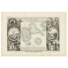
Description: This antique 19th-century map, titled La France, presents a detailed depiction of France’s overseas colonies, including territories in the Americas, Africa, and Oceania. The map is divided into four sections:
- Saint Pierre and Miquelon (near Newfoundland, Canada), showing the small French territories in the Atlantic.
- New Caledonia and the Marquesas Islands, featuring French possessions in the Pacific, including a scenic engraving of Nouméa.
- French Guiana (Amérique Française), highlighting the colony’s geography along the northern coast of South America.
- French African Islands, detailing islands such as Nosy Be, Nosy Komba, and Île Sainte-Marie near Madagascar.
The map includes hand-colored elements, primarily in pink, to distinguish French territories. Additionally, decorative engravings, such as a coastal view of Nouméa and illustrations of indigenous wildlife, enhance its visual appeal.
Produced by Migeon, a well-known 19th-century French cartographer, this map exemplifies France's colonial reach during the period.
Condition Report:
Paper Quality: Thick, high-quality 19th-century paper with natural aging.
Engraving: Well-preserved with crisp detailing.
Coloring: Original hand-coloring in pink remains vibrant.
Margins: Wide margins with light age-toning and minor foxing spots.
Overall Condition: Excellent for its age, with no major defects or tears.
Framing Tips:
Matting: Use a neutral acid-free mat to complement the soft tones of the aged paper.
Glass: Museum-grade UV-protective glass to prevent further fading.
Frame Style: A classic wooden frame with gold or dark brown accents will enhance the antique aesthetic.
Mounting: Ensure archival mounting to preserve the integrity of the paper over time.
- Dimensions:Height: 10.04 in (25.5 cm)Width: 13.78 in (35 cm)Depth: 0.01 in (0.2 mm)
- Materials and Techniques:
- Period:
- Date of Manufacture:1874
- Condition:Overall Condition: Very good for its age, with no significant tears or losses.
- Seller Location:Langweer, NL
- Reference Number:Seller: BG-13039-291stDibs: LU3054343838082
About the Seller
5.0
Recognized Seller
These prestigious sellers are industry leaders and represent the highest echelon for item quality and design.
Platinum Seller
Premium sellers with a 4.7+ rating and 24-hour response times
Established in 2009
1stDibs seller since 2017
2,513 sales on 1stDibs
Typical response time: <1 hour
- ShippingRetrieving quote...Shipping from: Langweer, Netherlands
- Return Policy
Authenticity Guarantee
In the unlikely event there’s an issue with an item’s authenticity, contact us within 1 year for a full refund. DetailsMoney-Back Guarantee
If your item is not as described, is damaged in transit, or does not arrive, contact us within 7 days for a full refund. Details24-Hour Cancellation
You have a 24-hour grace period in which to reconsider your purchase, with no questions asked.Vetted Professional Sellers
Our world-class sellers must adhere to strict standards for service and quality, maintaining the integrity of our listings.Price-Match Guarantee
If you find that a seller listed the same item for a lower price elsewhere, we’ll match it.Trusted Global Delivery
Our best-in-class carrier network provides specialized shipping options worldwide, including custom delivery.More From This Seller
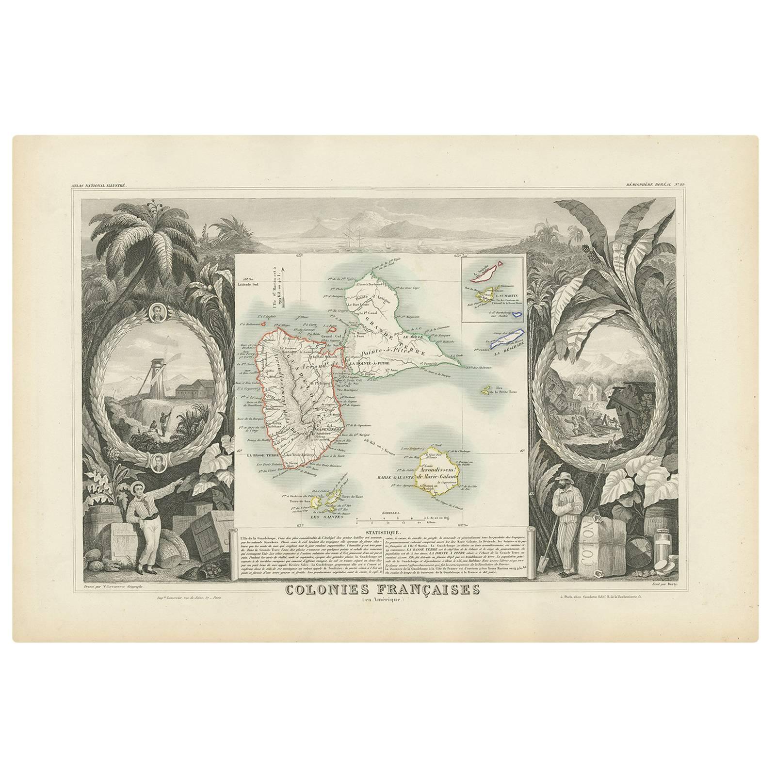
View AllAntique Map of the French Colony Guadeloupe by V. Levasseur, 1854
By Victor Levasseur
Located in Langweer, NL
Antique map titled 'Colonies Françaises (en Amerique). Detailed map of the island of Guadeloupe in the Caribbean Sea, with decorative frame containing views of the island. This map o...
Category
Antique Mid-19th Century Maps
Materials
Paper
$188 Sale Price
20% Off
Antique Map of Algeria and the French Colonies, 1875
Located in Langweer, NL
Antique map titled 'Algérie et Colonies Francaises'. Large map of Algeria and the French Colonies. This map originates from 'Atlas de Géographie Moderne Physique et Politique' by A. ...
Category
Antique Late 19th Century French Maps
Materials
Paper

$306 Sale Price
35% Off
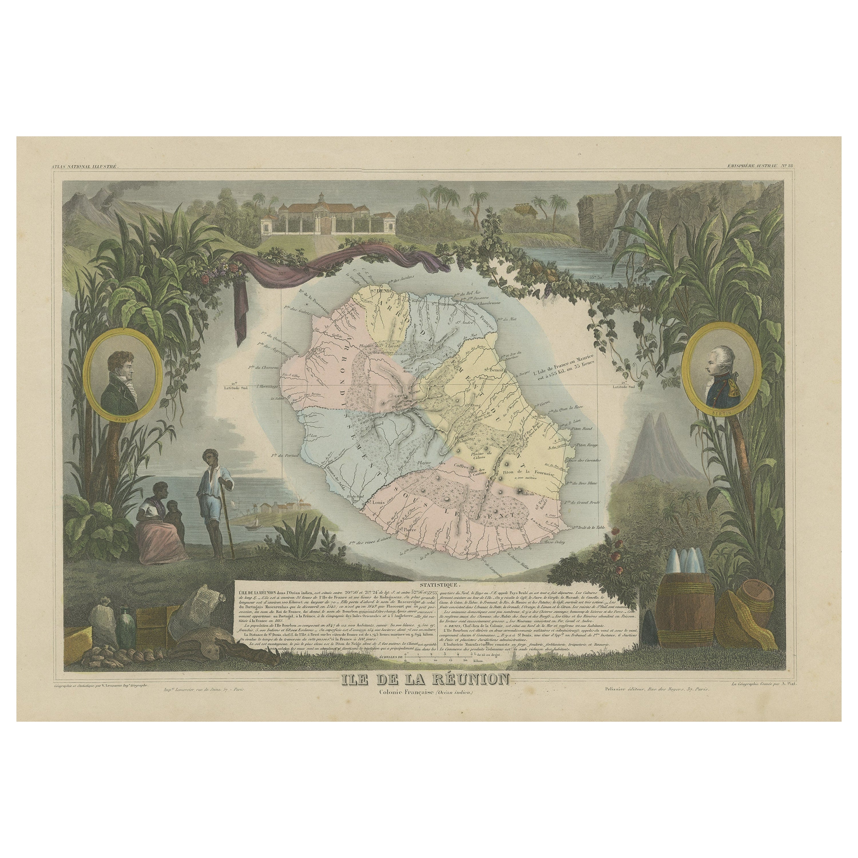
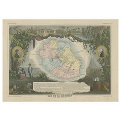
Antique Map of Bourbon, or Reunion, Colony of France
Located in Langweer, NL
Original antique map titled 'Ile de la Réunion'. This is a fascinating map of the French department of Ile. Bourbon or Reunion. Bourbon, or Reunion, is a volcanic island off the coas...
Category
Antique Mid-19th Century Maps
Materials
Paper
$320 Sale Price
20% Off
Antique Map of the Antilles and Central America – 1872
Located in Langweer, NL
Title: Antique Map of the Antilles and Central America – 1872
Description:
This finely detailed antique map, titled Antilles et Amérique Centrale, was published in 1872 under t...
Category
Antique 1870s Maps
Materials
Paper

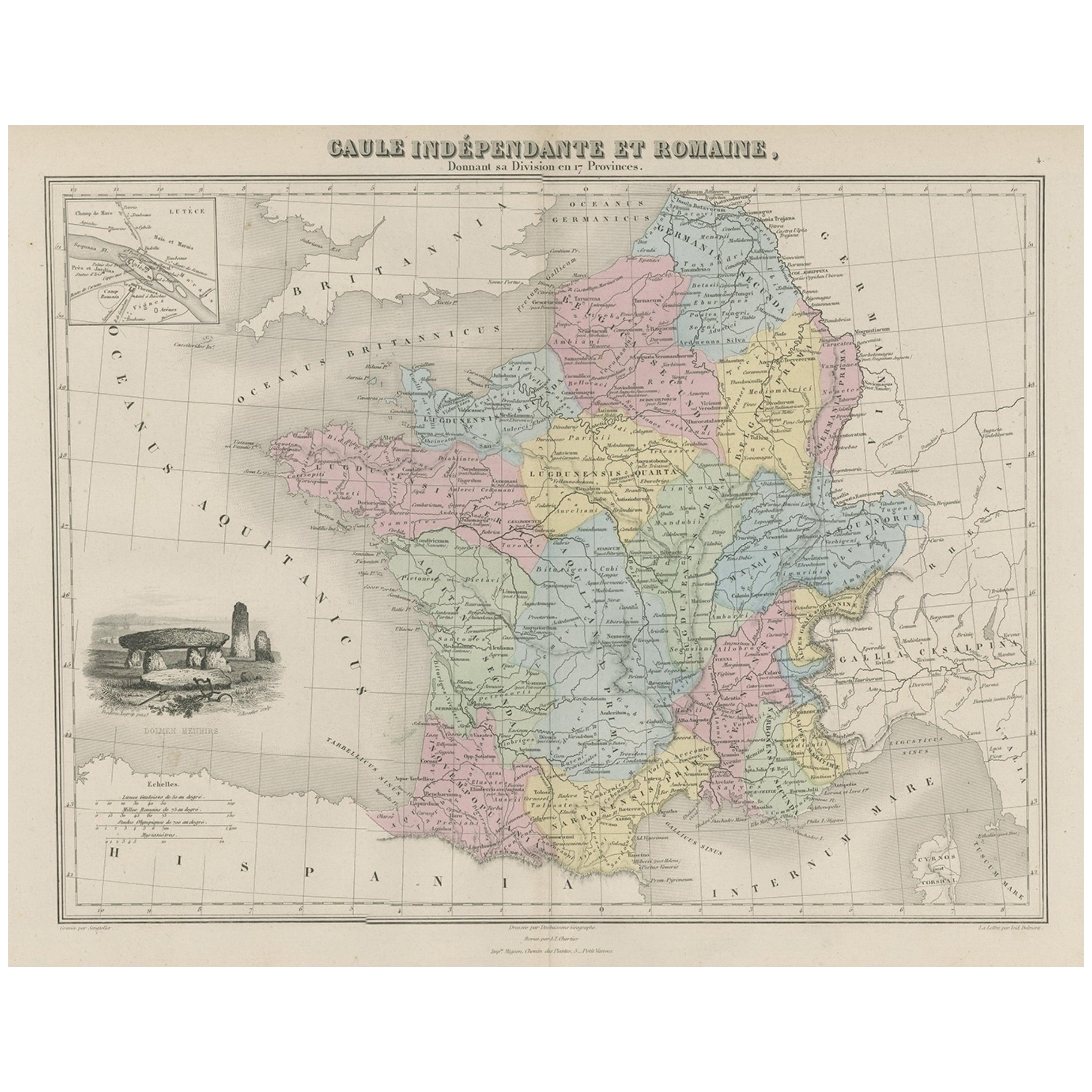
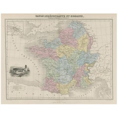
Antique Map of France in Ancient Roman Times, 1880
Located in Langweer, NL
Antique map titled 'Gaule indépendante et Romaine'.
Old map of Gaul or France in ancient Roman times. The map covers from the southern part of England (Britannia) to the north of S...
Category
Antique 19th Century Maps
Materials
Paper
$179 Sale Price
20% Off
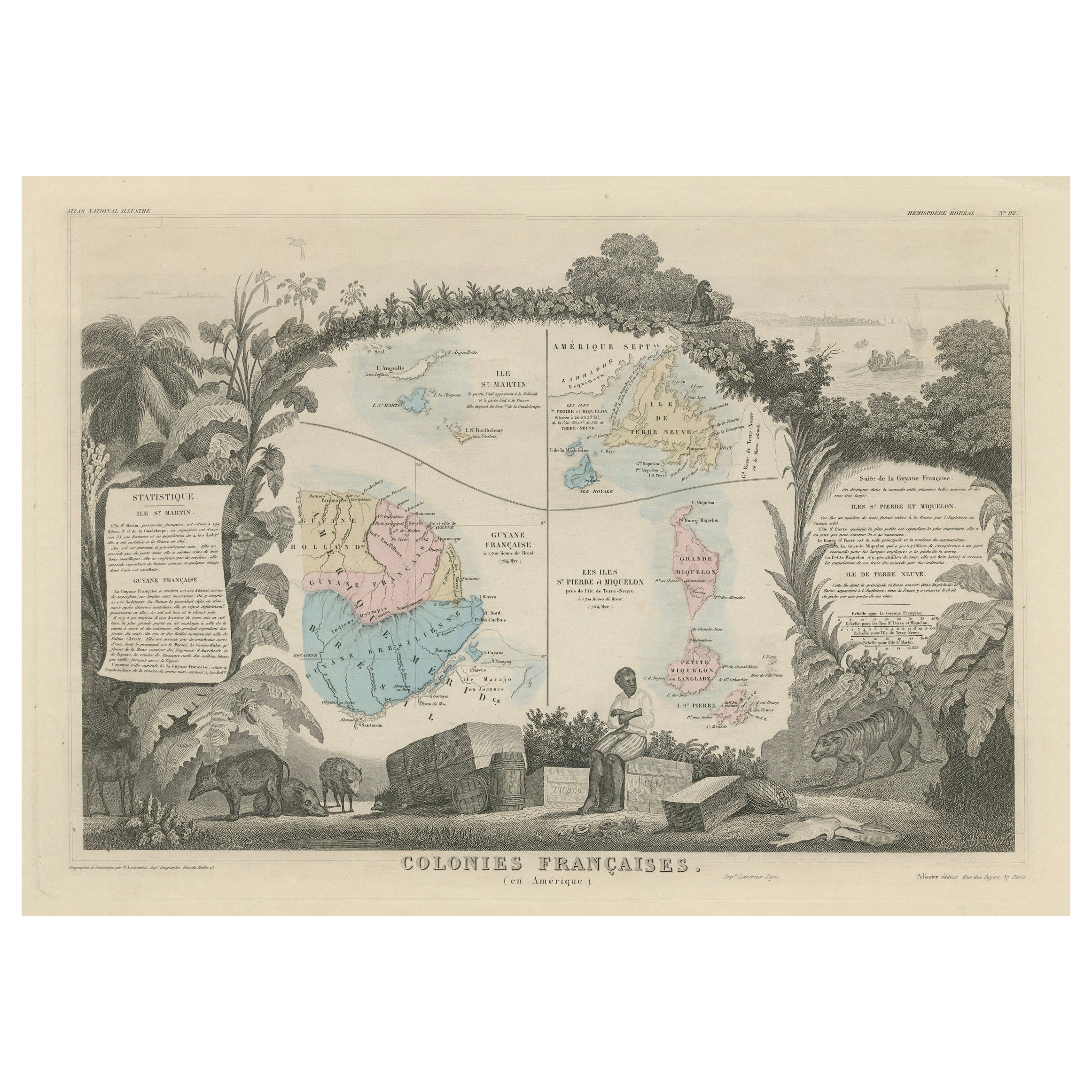
Map of French Colonies in the Americas: St. Martin, French Guiana and St. Pierre
Located in Langweer, NL
This is an intricately detailed map from 1852 titled *Colonies Françaises en Amérique*, depicting several key French colonies in the Americas.
The map focuses on regions such as Fr...
Category
Antique 1850s Maps
Materials
Paper
$179 Sale Price
20% Off
You May Also Like
Map Colonies Francaises Martinique, 1845
Located in BUNGAY, SUFFOLK
Colonies Francaises, Martinique, Amerique DU SUD
Geographie et Statistique par V.Levasseur. Ing'r Geographe.
Illustre par Raymond Bonheur, peintre.
Grave par Laguihermie, Rue St...
Category
Antique 19th Century French Maps
Materials
Paper

Ancient National Atlas of France with Marengo
Located in Alessandria, Piemonte
Ancient National Atlas of France with the department of Marengo: a rare French etching dated 1806.
ST/178.
Category
Antique Early 19th Century French Other Prints
Materials
Paper

Original Antique Map of US Possessions In The Pacific Ocean, C.1900
Located in St Annes, Lancashire
Fabulous map of US possessions in the Pacific Ocean
Original color.
Engraved and printed by the George F. Cram Company, Indianapolis.
Published, C.1900.
Unframed.
Free shipping.
Category
Antique 1890s American Maps
Materials
Paper

Large Original Antique Map of The Leeward Islands. 1894
Located in St Annes, Lancashire
Superb Antique map of The Leeward Islands
Published Edward Stanford, Charing Cross, London 1894
Original colour
Good condition
Unframed.
Free shipping
Category
Antique 1890s English Maps
Materials
Paper

Large 19th Century Map of France
Located in Pease pottage, West Sussex
Large 19th Century Map of France.
Remarkable condition, with a pleasing age worn patina.
Recently framed.
France Circa 1874.
Category
Antique Late 19th Century French Maps
Materials
Linen, Paper

Original Antique Map of United States, Grattan and Gilbert, 1843
Located in St Annes, Lancashire
Great map of United States
Drawn and engraved by Archer
Published by Grattan and Gilbert. 1843
Original colour
Unframed.
Category
Antique 1840s English Maps
Materials
Paper

More Ways To Browse
La Period Furniture
African American 19th Century
French Matting
Antique Furniture Newfoundland
Silver Metal Chair
Swedish Kilim
Vintage Scandanavian Chairs
Vintage Tropical Furniture
19th Century Red Glass
Antique French Console Table Tables
French 50s
Silver Bowl Large
Antique French Silk
Down Couch
Cobalt Blue Glass
Used Lighter Art
Blue Edge Glass
Mahogany 1950s Furniture