Items Similar to Antique Map of the Gulf of Mexico and Caribbean Islands by Tardieu, 1802


Want more images or videos?
Request additional images or videos from the seller
1 of 10
Antique Map of the Gulf of Mexico and Caribbean Islands by Tardieu, 1802
$537.23
$671.5420% Off
£399.65
£499.5620% Off
€448
€56020% Off
CA$735.65
CA$919.5720% Off
A$817.95
A$1,022.4320% Off
CHF 427.09
CHF 533.8620% Off
MX$9,956.42
MX$12,445.5220% Off
NOK 5,449.45
NOK 6,811.8120% Off
SEK 5,105.87
SEK 6,382.3420% Off
DKK 3,410.38
DKK 4,262.9720% Off
Shipping
Retrieving quote...The 1stDibs Promise:
Authenticity Guarantee,
Money-Back Guarantee,
24-Hour Cancellation
About the Item
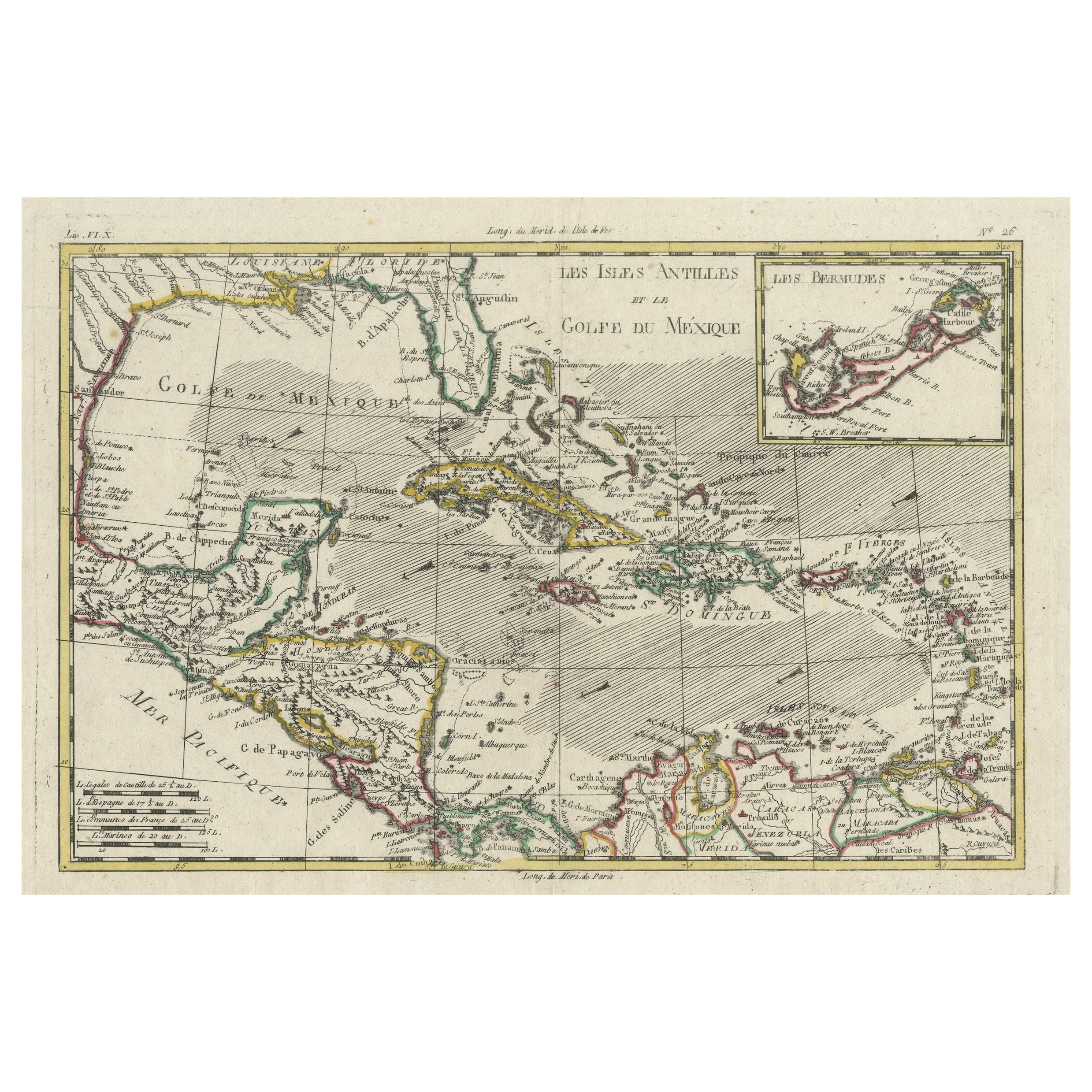
This is an original antique map titled "Carte du Golfe du Mexique et des Isles Antilles," depicting the Gulf of Mexico and the Caribbean islands. Created by Pierre Antoine Tardieu, this map provides a detailed view of the geographical and political landscape of the Gulf of Mexico, the Yucatan Peninsula, the Caribbean islands, and parts of Central America in the early 19th century.
### Map Details:
- **Title**: Carte du Golfe du Mexique et des Isles Antilles
- **Creator**: Pierre Antoine Tardieu (1784-1869)
- **Publication Date**: Early 19th century
- **Dimensions**: Approximately 34.5 x 43.5 cm (13.5 x 17.25 inches)
- **Features**: The map includes detailed representations of the Gulf of Mexico, the Caribbean islands, and parts of Central America, highlighting political boundaries, major cities, rivers, and other geographical features. The title cartouche is located in the upper right corner, and the outlines are hand-colored to distinguish different regions.
### Key Geographic Features and Areas:
1. **Gulf of Mexico**:
- The map shows the Gulf of Mexico, detailing the coastlines of present-day Mexico, the United States (Florida), and the Yucatan Peninsula.
- Major ports and coastal features are marked, including Veracruz and New Orleans.
2. **Caribbean Islands**:
- The map highlights the Caribbean islands, including Cuba, Hispaniola (Haiti and the Dominican Republic), Jamaica, Puerto Rico, and the Lesser Antilles.
- Various islands are labeled with their names and key cities or settlements.
3. **Central America**:
- Parts of Central America, including present-day countries such as Guatemala, Honduras, and Belize, are depicted.
- Important cities and ports along the Caribbean coast are marked.
### Condition Overview:
1. **Paper Quality**: The paper shows typical signs of aging, such as slight yellowing, but remains in good condition without major tears or damage.
2. **Edges and Corners**: The edges are slightly worn, with minor fraying and small tears, particularly near the center fold. These imperfections do not significantly impact the overall readability or aesthetic value.
3. **Center Fold**: A center fold is present, which is common for maps of this period that were often folded for storage or publication. The fold appears intact without significant separation or damage.
4. **Color and Print Quality**: The hand-colored outlines remain vibrant and clear, highlighting the borders of different regions. The print quality is excellent, with sharp, legible text and detailed illustrations.
5. **Staining and Spots**: There are a few spots and stains, particularly near the edges and along the fold. These do not obscure any critical details of the map.
### Historical Context
### Political Landscape
1. **Spanish Empire**:
- During the early 19th century, much of the region depicted on the map was under Spanish control, including Cuba, Puerto Rico, and parts of Central America.
- The Spanish territories were critical for trade and military strategy.
2. **British and French Territories**:
- The Caribbean islands were divided among various European powers, including the British (Jamaica, the Bahamas), the French (Haiti, Guadeloupe), and the Dutch (Curaçao, Aruba).
- These territories were significant for their economic contributions, particularly in sugar production.
3. **United States**:
- Florida, depicted on the map, was a Spanish territory but was of significant interest to the United States. It would later be acquired by the U.S. through the Adams-Onís Treaty in 1821.
### Socio-Economic Conditions
1. **Agriculture and Plantations**:
- The Caribbean islands were known for their plantation economies, producing sugar, tobacco, coffee, and other cash crops. These plantations relied heavily on enslaved labor.
- The fertile lands of the Yucatan Peninsula and parts of Central America also supported agricultural activities.
2. **Trade and Commerce**:
- Major port cities such as Havana, Veracruz, and New Orleans were critical hubs for trade. Goods were exported to Europe and other parts of the Americas.
- The Gulf of Mexico and the Caribbean Sea were essential maritime routes for the movement of goods, people, and ships.
### Cultural and Social Aspects
1. **Diverse Populations**:
- The region was home to diverse populations, including European colonists, African slaves, Indigenous peoples, and mixed-race communities.
- Cultural interactions and exchanges were common, leading to a rich blend of traditions and customs.
2. **Colonial Influence**:
- European colonial powers influenced the cultural, religious, and social structures of the region. Spanish, French, British, and Dutch customs and governance systems shaped the development of these territories.
### Conflicts and Changes
1. **Independence Movements**:
- The early 19th century was a period of significant political change, with independence movements sweeping through Latin America and the Caribbean. Many Spanish colonies in Central America and the Caribbean began to seek independence.
- The Haitian Revolution (1791-1804) was a notable example, leading to the establishment of Haiti as the first independent black republic.
2. **Piracy and Naval Conflicts**:
- The Caribbean was a hotspot for piracy and naval conflicts as European powers vied for control of trade routes and territories.
### Summary
The Gulf of Mexico and the Caribbean around 1800 were regions of strategic political importance, economic activity, and cultural diversity. The map by Pierre Antoine Tardieu provides a detailed and historically valuable representation of these areas, reflecting the geographical and political complexities of the time.
- Dimensions:Height: 16.34 in (41.5 cm)Width: 22.25 in (56.5 cm)Depth: 0.01 in (0.2 mm)
- Materials and Techniques:Paper,Engraved
- Period:
- Date of Manufacture:1802
- Condition:Good condition with minor age-related wear. Hand-colored boundaries are well-preserved, enhancing the clarity of regions and features. Fold lines as issued. Damp spot at bottom edge. Some wear due to handling and age. Study the images carefully.
- Seller Location:Langweer, NL
- Reference Number:Seller: BG-13769-381stDibs: LU3054340578842
About the Seller
5.0
Recognized Seller
These prestigious sellers are industry leaders and represent the highest echelon for item quality and design.
Platinum Seller
Premium sellers with a 4.7+ rating and 24-hour response times
Established in 2009
1stDibs seller since 2017
2,511 sales on 1stDibs
Typical response time: <1 hour
- ShippingRetrieving quote...Shipping from: Langweer, Netherlands
- Return Policy
Authenticity Guarantee
In the unlikely event there’s an issue with an item’s authenticity, contact us within 1 year for a full refund. DetailsMoney-Back Guarantee
If your item is not as described, is damaged in transit, or does not arrive, contact us within 7 days for a full refund. Details24-Hour Cancellation
You have a 24-hour grace period in which to reconsider your purchase, with no questions asked.Vetted Professional Sellers
Our world-class sellers must adhere to strict standards for service and quality, maintaining the integrity of our listings.Price-Match Guarantee
If you find that a seller listed the same item for a lower price elsewhere, we’ll match it.Trusted Global Delivery
Our best-in-class carrier network provides specialized shipping options worldwide, including custom delivery.More From This Seller
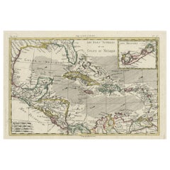
View AllAuthentic Antique Map of the Caribbean, Gulf Coast and Central America, 1787
Located in Langweer, NL
Antique map titled 'Les Isles Antilles et le Golfe du Méxique'. Original old map of the Caribbean, Gulf Coast and Central America. With inset map of Bermuda...
Category
Antique Late 18th Century Maps
Materials
Paper

$297 Sale Price
20% Off
Free Shipping
Original Engraving of the West Indies, Gulf of Mexico, Antilles, Caribbean, 1780
Located in Langweer, NL
Rigobert Bonne and G. Raynal's 1780 map of the West Indies, Gulf of Mexico, Antilles, and the Caribbean stands as a remarkable cartographic piece, offering a detailed and expansive v...
Category
Antique Late 18th Century Maps
Materials
Paper
$368 Sale Price
20% Off
Engraving of a Map of Florida, the Gulf Coast, Caribbean & Central America, 1728
Located in Langweer, NL
This exceptional antique map, titled "Nouvelle Carte Marine de Toute les Cotes de l´Amerique" and alternatively known as "Nieuwe groote en seer Curieuse Paskaart van Geheel-WestIndie...
Category
Antique Mid-18th Century Dutch Maps
Materials
Paper

$16,185
Free Shipping
Original Antique Map of the West Indies by J. Arrowsmith, 1842
Located in Langweer, NL
Title: "J. Arrowsmith's 19th Century Map of the West Indies"
This original antique map, crafted by J. Arrowsmith, details the West Indies with a focus on the Caribbean Sea and its s...
Category
Antique Early 19th Century Maps
Materials
Paper

Antique Map of the Antilles by Lapie, '1842'
Located in Langweer, NL
Antique map titled 'Carte des Antilles du Golfe du Méxique'. Map of the Antilles. This map originates from 'Atlas universel de géographie ancienne et moderne (..)' by Pierre M. Lapie...
Category
Antique Mid-19th Century Maps
Materials
Paper

$472 Sale Price
20% Off
Antique Map of the Antilles in the Caribbean, '1875'
Located in Langweer, NL
Antique map titled 'Carte des Iles Antilles'. Large map of the Antilles. This map originates from 'Atlas de Géographie Moderne Physique et Politique' by A. Levasseur. Published, 1875.
Category
Antique Late 19th Century Maps
Materials
Paper

$354 Sale Price
40% Off
You May Also Like
Original Antique Map of Central America / Florida, Arrowsmith, 1820
Located in St Annes, Lancashire
Great map of Central America.
Drawn under the direction of Arrowsmith.
Copper-plate engraving.
Published by Longman, Hurst, Rees, Orme and Brown, 1820
Unframed.
Category
Antique 1820s English Maps
Materials
Paper

Original Antique Map of South America. C.1780
Located in St Annes, Lancashire
Great map of South America
Copper-plate engraving
Published C.1780
Two small worm holes to left side of map
Unframed.
Category
Antique Early 1800s English Georgian Maps
Materials
Paper

West Coast of Africa, Guinea & Sierra Leone: An 18th Century Map by Bellin
By Jacques-Nicolas Bellin
Located in Alamo, CA
Jacques Bellin's copper-plate map entitled "Partie de la Coste de Guinee Dupuis la Riviere de Sierra Leona Jusquau Cap das Palmas", depicting the coast of Guinea and Sierra Leone in ...
Category
Antique Mid-18th Century French Maps
Materials
Paper

Early 19th Century Hand Colored Map of the United States and Caribbean Islands
Located in Hamilton, Ontario
Hand coloured early 19th century map by Giraldon of France titled "Etats Unis et Grandes Antilles" (United States and Greater Antilles).
Category
Antique Early 19th Century French Maps
Materials
Paper

$595 Sale Price
40% Off
Large Original Antique Map of The West Indies by Sidney Hall, 1847
Located in St Annes, Lancashire
Great map of The West Indies
Drawn and engraved by Sidney Hall
Steel engraving
Original colour outline
Published by A & C Black. 1847
Unframed
Free shipping.
Category
Antique 1840s Scottish Maps
Materials
Paper

California, Alaska and Mexico: 18th Century Hand-Colored Map by de Vaugondy
By Didier Robert de Vaugondy
Located in Alamo, CA
This is an 18th century hand-colored map of the western portions of North America entitled "Carte de la Californie et des Pays Nord-Ouest separés de l'Asie par le détroit d'Anian, ex...
Category
Antique 1770s French Maps
Materials
Paper

More Ways To Browse
Mexican Antiques
Latin America Antique
Map Storage
Dutch Military
Used Furniture Puerto Rico
Used Furniture Jamaica
Maritime Antiques
Bahamas Furniture
Antique Plantation Furniture
Guatemala Antique
Latin American Colonial Furniture
Used Furniture Bahamas
Cuban Antiques
Adams Antiques
Antique Mexican Religious
Antique Map Storage
Silver Over Copper
Vintage Barware Glasses