Items Similar to Antique Map of the Holy Land, showing the travels of Abraham, Isaac and Jacob


Want more images or videos?
Request additional images or videos from the seller
1 of 6
Antique Map of the Holy Land, showing the travels of Abraham, Isaac and Jacob
$532.68
$665.8520% Off
£396.72
£495.9020% Off
€448
€56020% Off
CA$747.11
CA$933.8820% Off
A$819.38
A$1,024.2220% Off
CHF 422.59
CHF 528.2320% Off
MX$9,788.17
MX$12,235.2220% Off
NOK 5,359.70
NOK 6,699.6320% Off
SEK 5,028.01
SEK 6,285.0120% Off
DKK 3,413.83
DKK 4,267.2820% Off
About the Item
Antique map titled 'Tabula Itineraria Patriarcharum Abrahami, Isaaci et Iacobi'. Decorative regional map of the Holy Land, showing the travels of Abraham, Isaac and Jacob. Published by J. Janssonius, circa 1652.
Jan Janssonius (also known as Johann or Jan Jansson or Janszoon) (1588-1664) was a renowned geographer and publisher of the seventeenth century, when the Dutch dominated map publishing in Europe. Born in Arnhem, Jan was first exposed to the trade via his father, who was also a bookseller and publisher. In 1612, Jan married the daughter of Jodocus Hondius, who was also a prominent mapmaker and seller. Jonssonius’ first maps date from 1616.
In the 1630s, Janssonius worked with his brother-in-law, Henricus Hondius. Their most successful venture was to reissue the Mercator-Hondius atlas. Jodocus Hondius had acquired the plates to the Mercator atlas, first published in 1595, and added 36 additional maps. After Hondius died in 1612, Henricus took over publication; Janssonius joined the venture in 1633. Eventually, the atlas was renamed the Atlas Novus and then the Atlas Major, by which time it had expanded to eleven volumes. Janssonius is also well known for his volume of English county maps, published in 1646.
- Dimensions:Height: 20.2 in (51.3 cm)Width: 23.9 in (60.7 cm)Depth: 0.02 in (0.5 mm)
- Materials and Techniques:
- Period:Mid-17th Century
- Date of Manufacture:c.1652
- Condition:Repaired: Repair on folding line. Age-related toning. Shows wear and soiling. French text on verso. Please study image carefully.
- Seller Location:Langweer, NL
- Reference Number:Seller: BG-13449-111stDibs: LU3054336226942
About the Seller
5.0
Recognized Seller
These prestigious sellers are industry leaders and represent the highest echelon for item quality and design.
Platinum Seller
Premium sellers with a 4.7+ rating and 24-hour response times
Established in 2009
1stDibs seller since 2017
2,675 sales on 1stDibs
Typical response time: <1 hour
- ShippingRetrieving quote...Shipping from: Langweer, Netherlands
- Return Policy
Authenticity Guarantee
In the unlikely event there’s an issue with an item’s authenticity, contact us within 1 year for a full refund. DetailsMoney-Back Guarantee
If your item is not as described, is damaged in transit, or does not arrive, contact us within 7 days for a full refund. Details24-Hour Cancellation
You have a 24-hour grace period in which to reconsider your purchase, with no questions asked.Vetted Professional Sellers
Our world-class sellers must adhere to strict standards for service and quality, maintaining the integrity of our listings.Price-Match Guarantee
If you find that a seller listed the same item for a lower price elsewhere, we’ll match it.Trusted Global Delivery
Our best-in-class carrier network provides specialized shipping options worldwide, including custom delivery.More From This Seller
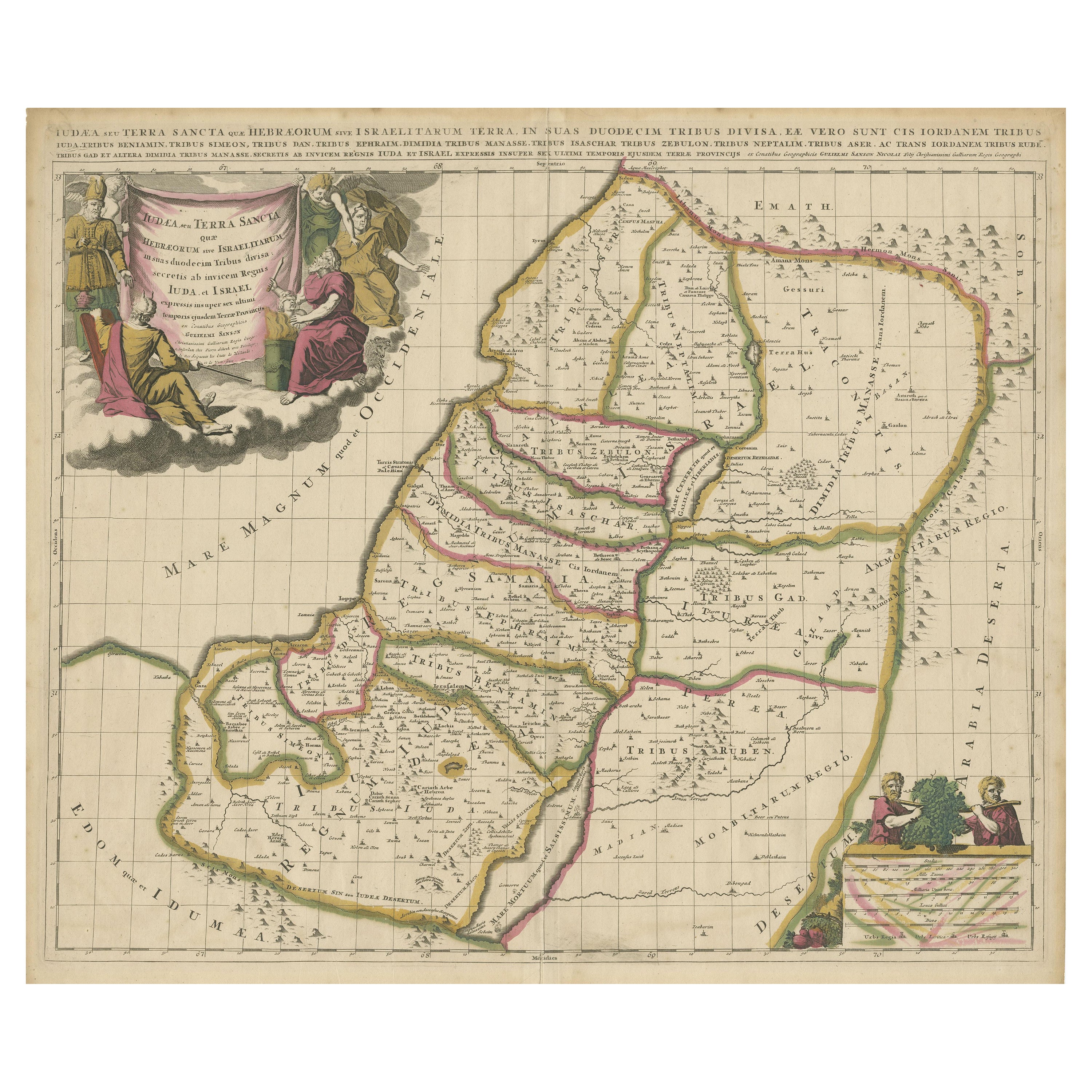
View AllAntique Map of the Holy Land, Showing the Location of the Various Tribes
Located in Langweer, NL
Antique map titled 'Judaea seu Terra Sancta quae Hebraeorum sive Israelitarum (..)'. Map of The Holy Land, showing the location of the various tribes, in two kingdoms, Judah and Isra...
Category
Antique Early 18th Century Maps
Materials
Paper
$1,141 Sale Price
20% Off
Free Shipping
Antique Map of the Holy Land Described in the Old and New Testament, ca.1660
Located in Langweer, NL
Antique map titled 'Geographiae Sacrae ex Veteri et Novo Testamento Desumptae Tabula Prima quae Totius Orbis Partes Continet.'
Map of the lands described in the Old and New Testame...
Category
Antique 1660s Maps
Materials
Paper

$808 Sale Price
20% Off
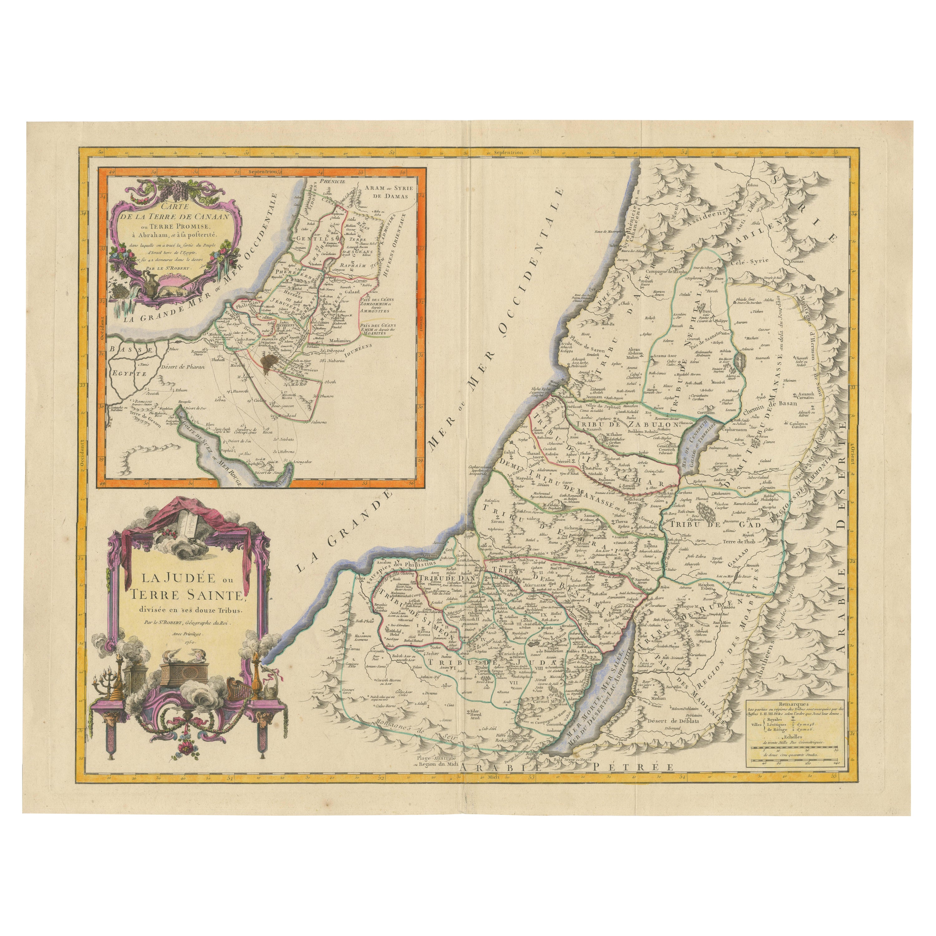
1750 Map of the Holy Land: The Land of Canaan and the Twelve Tribes
Located in Langweer, NL
Carte de la Terre de Canaan ou Terre Promise
Cartographer: Le St. Robert
Date of Publication: 1750
This exquisite 18th-century map, 'Carte de la Terre de Canaan ou Terre Promise', w...
Category
Antique 1750s French Maps
Materials
Paper

Antique Map of the Holy Land, c.1717
Located in Langweer, NL
Antique map Israel titled 'Tabula Geographica Terrae Sanctae'. Rare edition made after a map of the Holy Land by J. Bonfrerius. The map is oriented ...
Category
Antique 18th Century Maps
Materials
Paper

$370 Sale Price
20% Off
Antique Map of the Holy Land by Keur, 1748
Located in Langweer, NL
Antique Map Holy Land titled 'De Gelegentheyd van t'Paradys ende t'Landt Canaan, Mitsgaders d'eerst bewoonde Landen der Patriarchen'. Includes five decorative vignettes, including No...
Category
Antique 18th Century Maps
Materials
Paper

$331 Sale Price
20% Off
Antique Map of the Holy Land with Picture Frame Border
Located in Langweer, NL
Antique map titled 'Terre Sainte Suivant les Nouvelles Observations (..)'. Original old map of the Holy Land with the picture frame border. The term "Holy Land" usually refers to a t...
Category
Antique Early 18th Century Maps
Materials
Paper
You May Also Like
1633 Map "La Souverainete De Sedan Et De Raucourt, Et La Prevoste Ric0011
Located in Norton, MA
1653 map entitled
"La Souverainete de Sedan et de Raucourt, et la Prevoste de Doncheri,"
Ric0011
Description:
Lovely map centered on Sedan and Doncheri and the Meuze River fr...
Category
Antique 17th Century Dutch Maps
Materials
Paper

17th Century Dutch Map of the Holy Land at the Time of Jesus by Visscher
By Nicolaus Visscher
Located in Alamo, CA
This detailed Dutch map entitled "Het Beloofe de Landt Canaan door wandelt van onsen Salichmaecker Iesu Christo, nessens syne Apostelen" by Nicolaes Visscher (1610-1679), published i...
Category
1660s Prints and Multiples
Materials
Engraving

Map Holy Land La Terre Sainte Engraved van Loon Published N de Fer 1703 French
Located in BUNGAY, SUFFOLK
La Terre Sainte, The Holy Land, Tiree Des Memoires De M.De.La Rue. Par N. de Fer. Geographe de Sa Majeste Catoliq et de Monseigneur le Dauphin. Avec Privil du Roi 1703
Detailed map of the Holy Land from Nicholas de Fer's L'Atlas Curieux ou le Monde. East is oriented at the top.
MAKER Nicolas de Fer 1646-1720
The French cartographer and engraver, Nicolas de Fer, was a master at creating maps that were works of art. The maps that he published were printed during the Baroque period when the decorative arts were characterized by ornate detail. De Fer’s detailed maps and atlases were valued more for their decorative content than their geographical accuracy.
Nicolas de Fer was born in 1646. His father, Antoine de Fer, owned a mapmaking firm. At the age of twelve, Nicolas was apprenticed to a Parisian engraver named Louis Spirinx. The family business was starting to decline when his father died in 1673. Nicolas de Fer’s mother, Genevieve, took over the business after the death of her husband. In 1687 the business was passed on to Nicolas and the profits increased after he took over the firm. Nicolas de Fer was a prolific cartographer who produced atlases and hundreds of single maps. He eventually became the official geographer to King Louis XIV of France and King Philip V...
Category
Antique Early 1700s French Louis XIV Maps
Materials
Paper

Rare Original Map of New Amsterdam (New York) – “Restitutio”, ca. 1674 –
Located in Dronten, NL
An exceptionally rare and original 17th-century engraving of New Amsterdam, now New York City, published by the renowned Amsterdam cartographer Carel (Carolus) Allard around 1674. Kn...
Category
Antique 17th Century Dutch Maps
Materials
Paper

1718 Ides & Witsen Map "Route D'amsterdam a Moscow Et De La Ispahan Et Gamron
Located in Norton, MA
1718 Ides & Witsen map, entitled
"Route D'Amsterdam A Moscow Et De La Ispahan Et Gamron,"
Ric.b005
Subject: Eastern Europe and Central Asia
Period: 1718 (published)
Publicati...
Category
Antique Early 18th Century Dutch Maps
Materials
Paper

1646 Jansson Map Entitled "Procinvia Connactiae, " Ric.a006
Located in Norton, MA
1646 Jansson map entitled
"Procinvia connactiae,"
Ric.a006
Description: The PROVINCE of CONNAVGT 490 x 380From vol 4 of Jansson's Atlas Novus 1646, published in Amsterdam with...
Category
Antique 17th Century Unknown Maps
Materials
Paper

More Ways To Browse
Irish Antiques 16th Century
Ithaca Antique Map
Leonard Jones
Russia Globe
Salt Lake City Used Furniture
World Map Copper
Green French Glass
Mid Century Modern Wicker Chair
Mid-Century Modern Wicker Chairs
Curved Back Mid Century Dining Chairs
Glass Stopper
Stretcher Tables
Antique French Lithographs
M Table
Antique Sultanabad Carpets
China Chair
English Antique Desks
Used Beige Sofa