Items Similar to Antique Map of Mauritania 'Africa' by G. Ruscelli, 1574


Want more images or videos?
Request additional images or videos from the seller
1 of 5
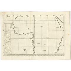
Antique Map of Mauritania 'Africa' by G. Ruscelli, 1574
$335.77
$419.7120% Off
£249.78
£312.2220% Off
€280
€35020% Off
CA$459.78
CA$574.7320% Off
A$511.22
A$639.0220% Off
CHF 266.93
CHF 333.6620% Off
MX$6,222.76
MX$7,778.4520% Off
NOK 3,405.90
NOK 4,257.3820% Off
SEK 3,191.17
SEK 3,988.9620% Off
DKK 2,131.49
DKK 2,664.3620% Off
Shipping
Retrieving quote...The 1stDibs Promise:
Authenticity Guarantee,
Money-Back Guarantee,
24-Hour Cancellation
About the Item
A very rare mid-16th century black and white map of North and West Africa called Mauritania by the Italian cartographic editor Girolamo Ruscelli. This print originates from the second edition of Ptolemy's 'Geografica'. Passe partout included, Italian text on verso.
- Dimensions:Height: 13.47 in (34.2 cm)Width: 16.66 in (42.3 cm)Depth: 0.12 in (3 mm)
- Materials and Techniques:
- Period:
- Date of Manufacture:1574
- Condition:Please study image carefully.
- Seller Location:Langweer, NL
- Reference Number:Seller: BG-062251stDibs: LU305439781551
About the Seller
5.0
Recognized Seller
These prestigious sellers are industry leaders and represent the highest echelon for item quality and design.
Platinum Seller
Premium sellers with a 4.7+ rating and 24-hour response times
Established in 2009
1stDibs seller since 2017
2,511 sales on 1stDibs
Typical response time: <1 hour
- ShippingRetrieving quote...Shipping from: Langweer, Netherlands
- Return Policy
Authenticity Guarantee
In the unlikely event there’s an issue with an item’s authenticity, contact us within 1 year for a full refund. DetailsMoney-Back Guarantee
If your item is not as described, is damaged in transit, or does not arrive, contact us within 7 days for a full refund. Details24-Hour Cancellation
You have a 24-hour grace period in which to reconsider your purchase, with no questions asked.Vetted Professional Sellers
Our world-class sellers must adhere to strict standards for service and quality, maintaining the integrity of our listings.Price-Match Guarantee
If you find that a seller listed the same item for a lower price elsewhere, we’ll match it.Trusted Global Delivery
Our best-in-class carrier network provides specialized shipping options worldwide, including custom delivery.More From This Seller
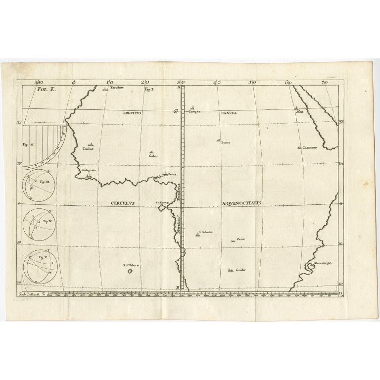
View AllRemarkable Antique Map of Central Africa by Scherer, c.1703
Located in Langweer, NL
Untitled map of Central Africa depicting Tarodant, Lempta, Guber, Borno, Chaxumo, Tombut, Melegvete, Benin, S. Salvator, Zaire, Gondar, S. Helena and Mozambique. Printed for Scherer'...
Category
Antique 18th Century Maps
Materials
Paper
$249 Sale Price
20% Off
Rare Antique Map of 'Barbarie' or Northern Africa, 1655
Located in Langweer, NL
Antique map titled 'Partie de la Coste de Barbarie en Africque ou sont les Royaumes de Tunis et Tripoli et Pays Circomvoisins'. This map depicts North Africa with Malta and originate...
Category
Antique 17th Century Maps
Materials
Paper

Original Antique Map of Northern Africa by Van Dùren (1749)
Located in Langweer, NL
This is a German antique map titled 'Neue Geographische Vorstellung der Mitternaechtlichen Küste von Africa'. Original antique engraving of Northern Africa extending from the Strait ...
Category
Antique Mid-18th Century Maps
Materials
Paper

$335 Sale Price
20% Off
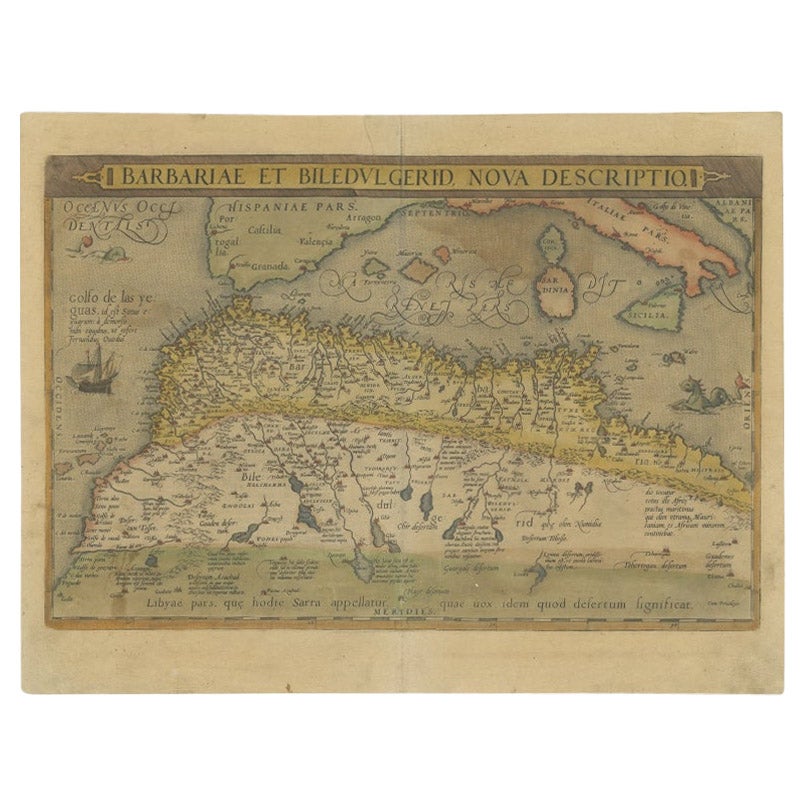
Antique Map of North Africa by Ortelius, c.1580
Located in Langweer, NL
Antique map titled 'Barbariae et Biledulgerid Nova Descriptio'. Original antique map of North Africa. The map covers the regions of Barbaria and Biledulgerid, essentially the territo...
Category
Antique 16th Century Maps
Materials
Paper
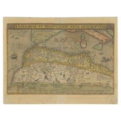
$344 Sale Price
20% Off
Antique Map of Peru by van der Aa, 'circa 1720'
Located in Langweer, NL
Antique map titled 'Le Perou, Grand Pays de l Amerique Meridionale (..)'. Decorative map of Peru including portions of Ecuador and northern Chile and Boliv...
Category
Antique Early 18th Century Maps
Materials
Paper

$719 Sale Price
20% Off
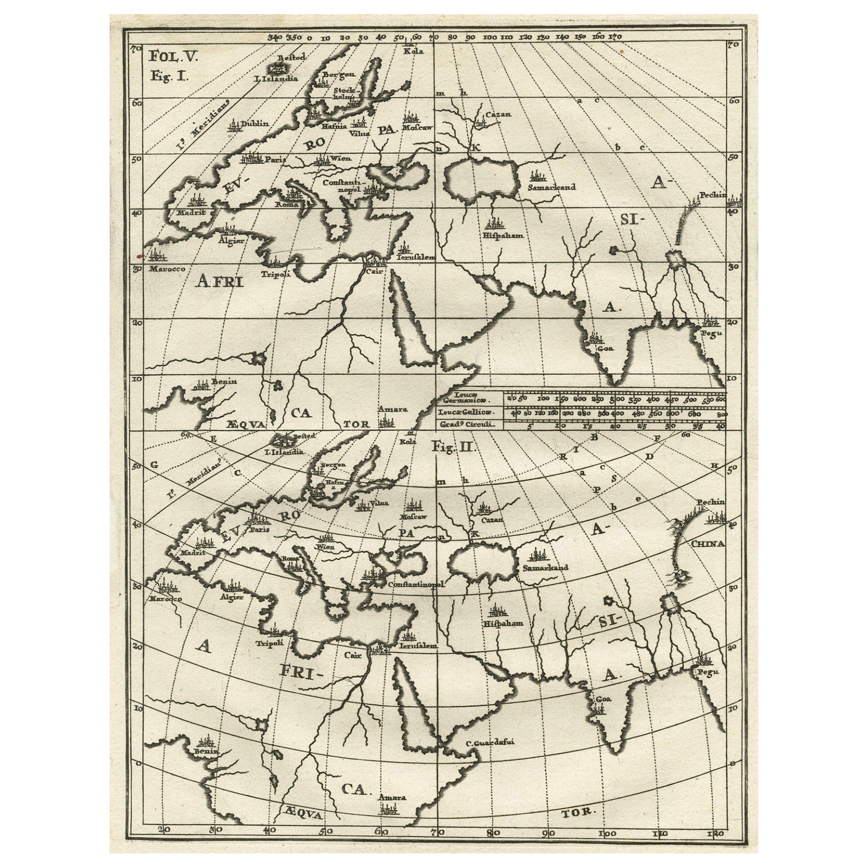
Intriguing Antique Map of Europe, Asia and Africa by Scherer, c.1703
Located in Langweer, NL
Two maps on a single sheet showing Europe, Asia and Africa, each depicting nearly the same area. On close examination there are slight differences. Major cities are located. Printed ...
Category
Antique 18th Century Maps
Materials
Paper
$287 Sale Price
20% Off
You May Also Like
"Nova Barbariae Descriptio", a 17th Century Hand-Colored Map of North Africa
By Johannes Janssonius
Located in Alamo, CA
This original attractive 17th century hand-colored map of North Africa entitled "Nova Barbariae Descriptio" by Johannes Janssonius was published in Paris in 1635. It includes the Med...
Category
Antique Mid-17th Century Dutch Maps
Materials
Paper

Antique Map - Mare Pacificum - Etching by Johannes Janssonius - 1650s
By Johannes Janssonius
Located in Roma, IT
Mare Pacificum is an antique map realized in 1650 by Johannes Janssonius (1588-1664).
The Map is Hand-colored etching, with coeval watercolorang.
Good conditions with slight foxing...
Category
1650s Modern Figurative Prints
Materials
Etching

Africa: A Large 17th Century Hand-Colored Map by Sanson and Jaillot
By Nicolas Sanson
Located in Alamo, CA
This large original hand-colored copperplate engraved map of Africa entitled "L'Afrique divisee suivant l'estendue de ses principales parties ou sont distingues les uns des autres, L...
Category
Antique 1690s French Maps
Materials
Paper

Antique Map - Mar Di Athiopia - Etching by Johannes Janssonius - 1650s
By Johannes Janssonius
Located in Roma, IT
Antique Map - Mar Di Athiopia is an antique map realized in 1650 by Johannes Janssonius (1588-1664).
The Map is Hand-colored etching, with coeval watercolorang.
Good conditions wit...
Category
1650s Modern Figurative Prints
Materials
Etching

1627 Hendrik Hondius Map Entitled "Vltoniae Orientalis Pars, " Ric.a009
Located in Norton, MA
1627 Hendrik Hondius map entitled
"Vltoniae orientalis pars,"
Ric.a009
Title:
Vltoniae orientalis : pars
Title (alt.) :
Ultoniae orientalis pars
Creator:
Mercator, Gerh...
Category
Antique 17th Century Dutch Maps
Materials
Paper

Antique Map - Gallia - Etching by Johannes Janssonius - 1650s
By Johannes Janssonius
Located in Roma, IT
Antique Map - Gallia is an antique map realized in 1650 by Johannes Janssonius (1588-1664).
The Map is Hand-colored etching, with coeval watercoloring.
Good conditions with slight ...
Category
1650s Modern Figurative Prints
Materials
Etching

More Ways To Browse
Japanese Silver Ceramics
One Of A Kind Chair
Used Oak Dining Room Chairs
Childrens Vintage Poster
Vintage Travel Poster Mid Century
Desk Key
Carved Cabriole Table
Dark Antique Table
White Wooden Table
Antique Wall Table
1960 Chair Wood Danish
Unusual Dining Table
Antique Dutch Plates
Mdf Table
Showcase Coffee Table
Space Age Orange
Vallauris France
Silver Ladle