Items Similar to Antique Map of Northern Italy by J. Tallis, circa 1851

Want more images or videos?
Request additional images or videos from the seller
1 of 6
Antique Map of Northern Italy by J. Tallis, circa 1851
$170.13
$324.9047% Off
£127.52
£243.5347% Off
€144
€27547% Off
CA$233.73
CA$446.3647% Off
A$260.94
A$498.3247% Off
CHF 136.73
CHF 261.1147% Off
MX$3,194.11
MX$6,099.8747% Off
NOK 1,736.43
NOK 3,316.1047% Off
SEK 1,637.23
SEK 3,126.6647% Off
DKK 1,096.18
DKK 2,093.4047% Off
Shipping
Retrieving quote...The 1stDibs Promise:
Authenticity Guarantee,
Money-Back Guarantee,
24-Hour Cancellation
About the Item
A highly decorative mid-19th century map of Northern Italy which was drawn and engraved by John Rapkin (vignettes by A. H. Wray & J. B. Allen) and published in John Tallis & co.'s The Illustrated Atlas (London & New York: c.1851).
The Illustrated Atlas, published from 1849 to 1853, was the last decorative world atlas. The Northern Italy map was typical of the many fine ones which appeared in this work with its ornamental border and attractive vignettes. Illustrated are fine views of St. Peter's, Rome; the Grand Canal, Venice and a religious procession.
- Dimensions:Height: 10.44 in (26.5 cm)Width: 14.69 in (37.3 cm)Depth: 0.02 in (0.5 mm)
- Materials and Techniques:
- Period:
- Date of Manufacture:circa 1851
- Condition:Please study image carefully.
- Seller Location:Langweer, NL
- Reference Number:Seller: BG-033331stDibs: LU305439345261
About the Seller
5.0
Recognized Seller
These prestigious sellers are industry leaders and represent the highest echelon for item quality and design.
Platinum Seller
Premium sellers with a 4.7+ rating and 24-hour response times
Established in 2009
1stDibs seller since 2017
2,511 sales on 1stDibs
Typical response time: <1 hour
- ShippingRetrieving quote...Shipping from: Langweer, Netherlands
- Return Policy
Authenticity Guarantee
In the unlikely event there’s an issue with an item’s authenticity, contact us within 1 year for a full refund. DetailsMoney-Back Guarantee
If your item is not as described, is damaged in transit, or does not arrive, contact us within 7 days for a full refund. Details24-Hour Cancellation
You have a 24-hour grace period in which to reconsider your purchase, with no questions asked.Vetted Professional Sellers
Our world-class sellers must adhere to strict standards for service and quality, maintaining the integrity of our listings.Price-Match Guarantee
If you find that a seller listed the same item for a lower price elsewhere, we’ll match it.Trusted Global Delivery
Our best-in-class carrier network provides specialized shipping options worldwide, including custom delivery.More From This Seller
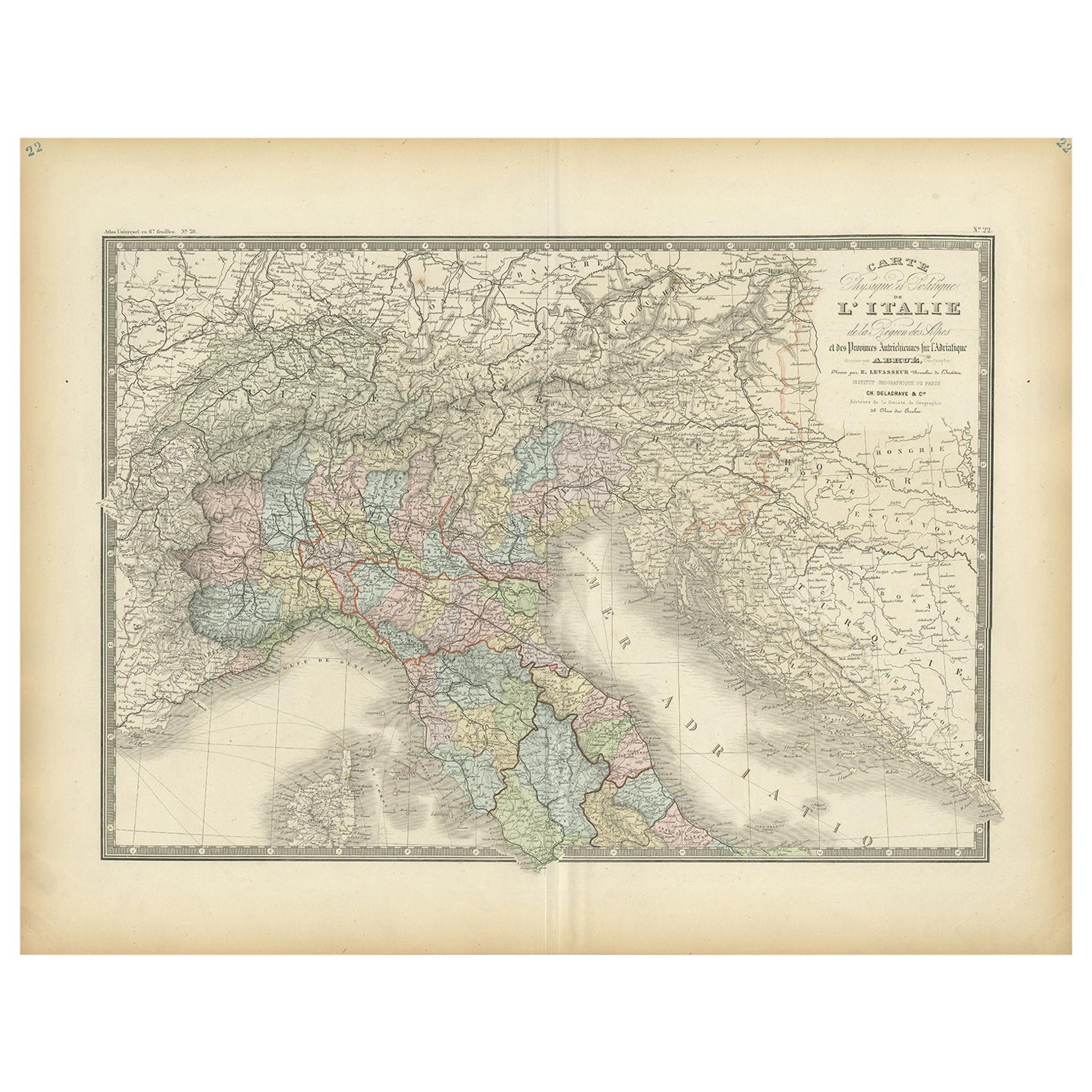
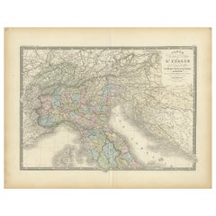
View AllAntique Map of Northern Italy by Levasseur, 1875
Located in Langweer, NL
Antique map titled 'Carte l'Italie (..)'. Large map of Northern Italy. This map originates from 'Atlas de Géographie Moderne Physique et Politique' by A. Levasseur. Published 1875.
Category
Antique Late 19th Century Maps
Materials
Paper
$378 Sale Price
20% Off
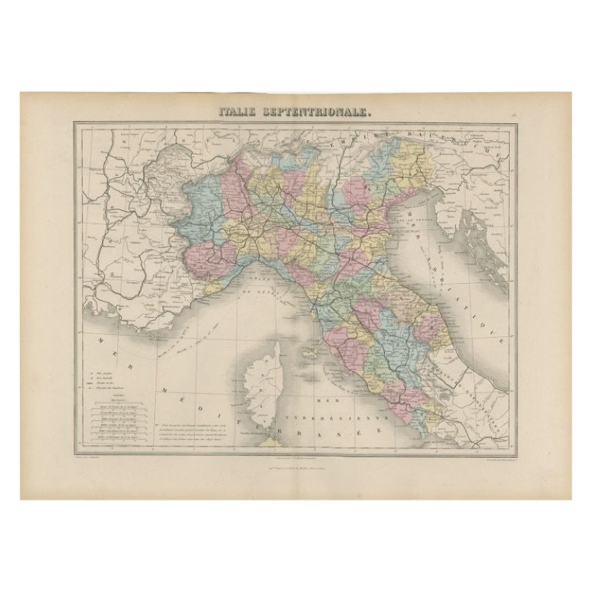
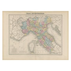
Antique Map of Northern Italy by Migeon, 1880
Located in Langweer, NL
Antique map titled 'Italie Septentrionale'. Old map of the northern part of Italy. This map originates from 'Géographie Universelle Atlas-Migeon' by J. Migeon. Artists and Engravers:...
Category
Antique 19th Century Maps
Materials
Paper
$99 Sale Price
20% Off
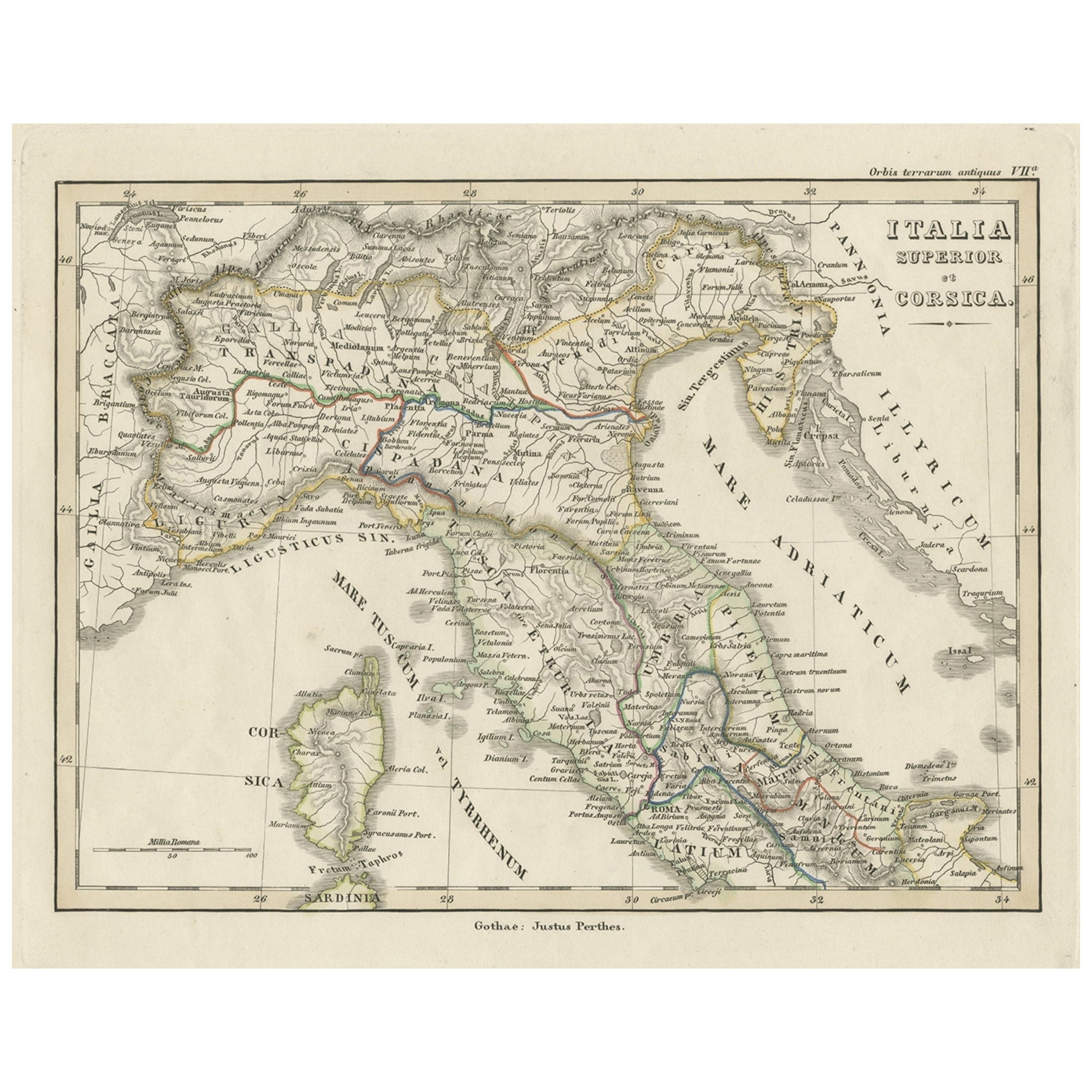
Antique Map of Italy and Corse in Ancient Times, 1848
Located in Langweer, NL
Antique map titled 'Italia Superior et Corsica'.
Old map of northern Italy and Corse originating from 'Orbis Terrarum Antiquus in usum Scholarum'. Artists and Engravers: Publishe...
Category
Antique 19th Century Maps
Materials
Paper

$245 Sale Price
20% Off
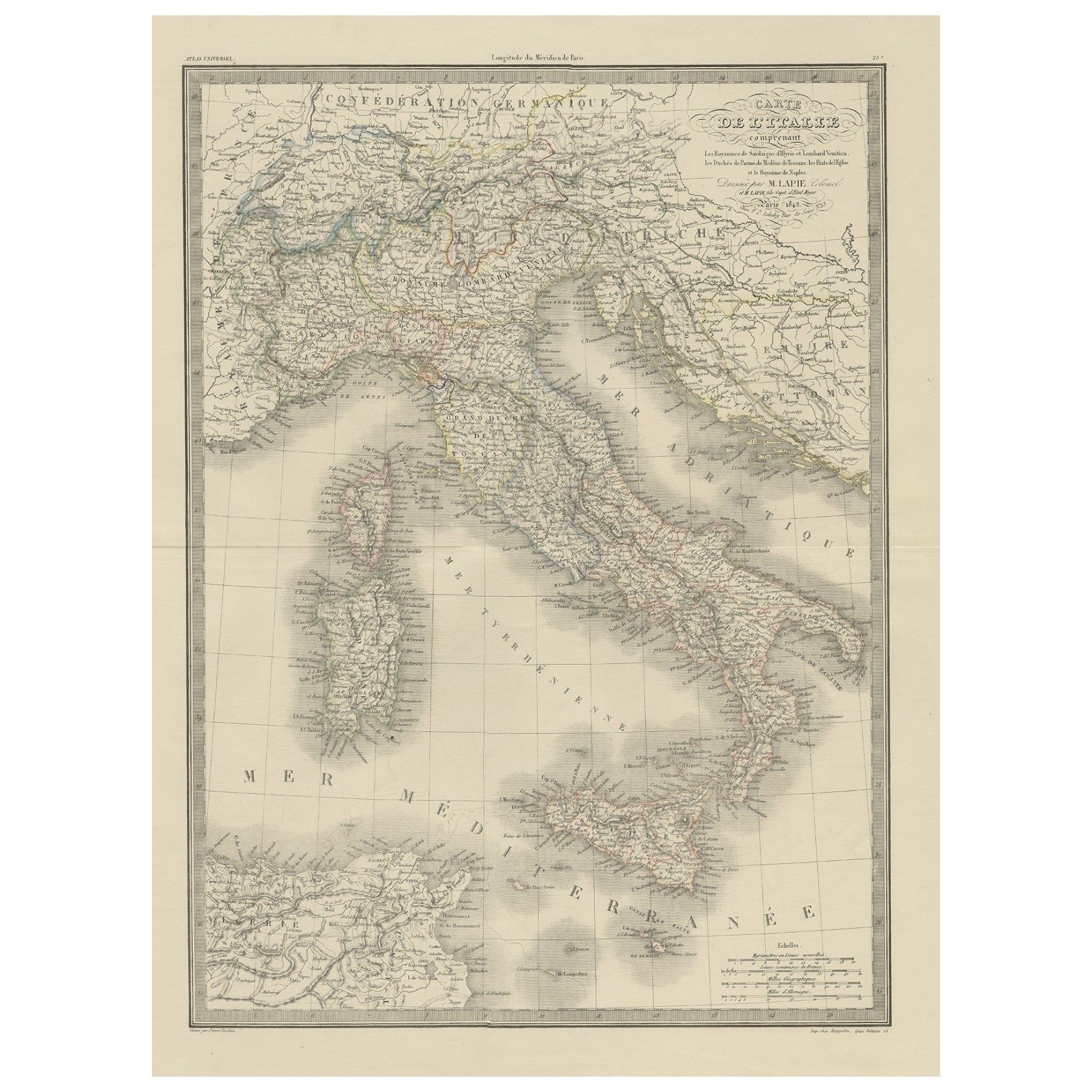
Antique Map of Italy from an Old French Atlas, 1842
Located in Langweer, NL
Antique map titled 'Carte de l'Italie'. Map of Italy.
This map originates from 'Atlas universel de géographie ancienne et moderne (..)' by Pierre M. Lapie and Alexandre E. Lapie. A...
Category
Antique 19th Century Maps
Materials
Paper
$311 Sale Price
20% Off
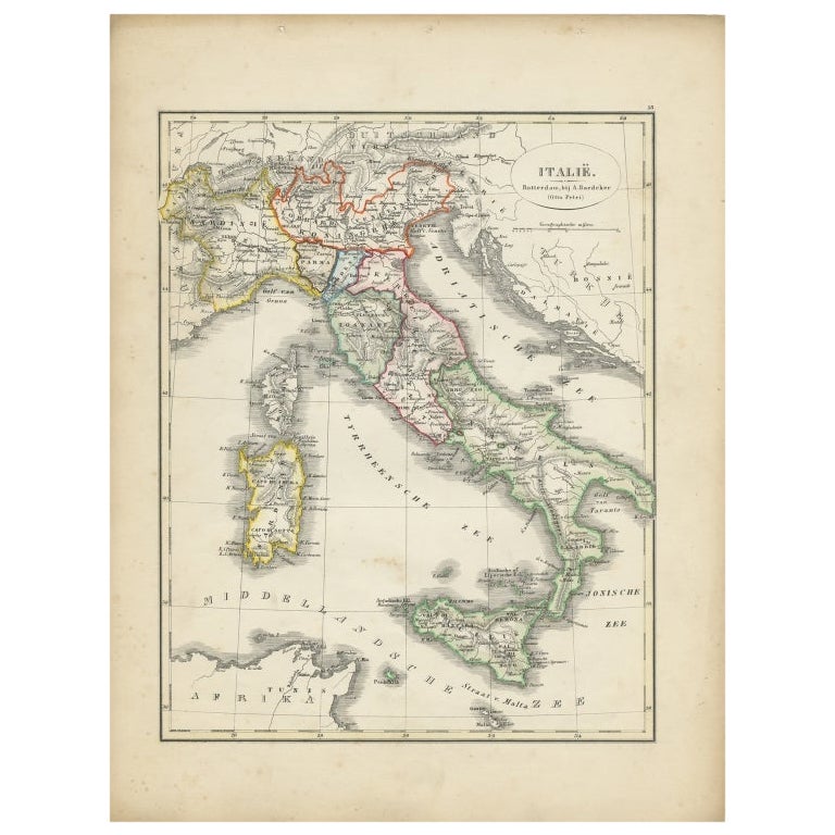
Antique Map of Italy with Hand-Colored Borders, 1852
Located in Langweer, NL
Antique map titled 'Italië'. Map of Italy. This map originates from 'School-Atlas van alle deelen der Aarde' by Otto Petri. Artists and Engravers: Published by A. Baedeker (Otto Petr...
Category
Antique 19th Century Maps
Materials
Paper

$207 Sale Price
20% Off
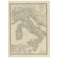
Antique Map of Italy by Lapie, 1842
Located in Langweer, NL
Antique map titled 'Carte de l'Italie Ancienne'. Map of Italy. This map originates from 'Atlas universel de géographie ancienne et moderne (..)' by Pierre...
Category
Antique Mid-19th Century Maps
Materials
Paper

$472 Sale Price
20% Off
You May Also Like
Large Original Antique Map of Italy. John Dower, 1861
Located in St Annes, Lancashire
Great map of Italy
Lithograph engraving by John Dower
Original colour
Published, 1861
Unframed
Good condition / repair to top right corner seen in last image
Category
Antique 1860s English Victorian Maps
Materials
Paper

Large Original Antique Map of The South of Italy. John Dower, 1861
Located in St Annes, Lancashire
Great map of the South of Italy
Lithograph engraving by John Dower
Original colour
Published, 1861
Unframed
Good condition
Free shipping
Category
Antique 1860s English Victorian Maps
Materials
Paper

Italy, Central and Southern Part. Century Atlas antique map
Located in Melbourne, Victoria
'The Century Atlas. Italy, Central and Southern Part.'
Original antique map, 1903.
Inset maps of Sicily and Naples.
Central fold as issued. Map name an...
Category
Early 20th Century Victorian More Prints
Materials
Lithograph

Italy, Northern Part. Century Atlas antique vintage map
Located in Melbourne, Victoria
'The Century Atlas. Italy, Northern Part.'
Original antique map, 1903.
Central fold as issued. Map name and number printed on the reverse corners.
Sheet 29.5cm by 40cm.
Category
Early 20th Century Victorian More Prints
Materials
Lithograph

Antique Map of Italy Drawn & Engraved by R. Scott for Thomsons, Edinburgh 1814
Located in London, GB
This is a magnificent museum quality antique hand-coloured map of Italy, dating from 1814.
This historic and very rare antique map was drawn and engraved by R. Scott for Thomsons, New General Atlas, Edinburgh.
The map is very detailed and the various colours - yellow, grey and green - beautifully highlight the different natural and political divisions of Italy as it was before the Italian Unification...
Category
Antique 1810s Scottish Prints
Materials
Other

Large Original Antique Map of South Italy and Malta by Sidney Hall, 1847
Located in St Annes, Lancashire
Great map of South Italy and Malta
Drawn by Sidney Hall
Steel engraving by G.Aikman
Original color outline
Published by A & C Black. 1847
Un...
Category
Antique 1840s Scottish Maps
Materials
Paper

More Ways To Browse
Northern Furniture Co
Japanese Silver Ceramics
One Of A Kind Chair
Used Oak Dining Room Chairs
Childrens Vintage Poster
Vintage Travel Poster Mid Century
Desk Key
Carved Cabriole Table
Dark Antique Table
White Wooden Table
Antique Wall Table
1960 Chair Wood Danish
Unusual Dining Table
Antique Dutch Plates
Mdf Table
Showcase Coffee Table
Space Age Orange
Vallauris France