Items Similar to Antique Map of Prussia, Hanover, Netherlands & Belgium – 1858


Want more images or videos?
Request additional images or videos from the seller
1 of 11
Antique Map of Prussia, Hanover, Netherlands & Belgium – 1858
$353.14
£265.86
€299
CA$486.47
A$544.81
CHF 284.27
MX$6,654.66
NOK 3,616.80
SEK 3,409.27
DKK 2,276.03
About the Item
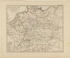
Antique Map of Northwestern Germany, Netherlands & Belgium – 1858
Detailed 19th-century engraved map titled "Nordwestliches Deutschland, Kgr. der Niederlande, Kgr. Belgien" (Northwestern Germany, Kingdom of the Netherlands, Kingdom of Belgium), published by Justus Perthes in Gotha in 1858. This map highlights the regions of Prussia, Hanover, Oldenburg, Westphalia, and surrounding areas, along with the neighboring Low Countries.
The map depicts the dense political landscape of mid-19th-century northwestern Europe, with state and provincial boundaries outlined in hand-applied colors. The Netherlands is bordered in red, while Belgium is bordered in yellow, reflecting the political boundaries established after Belgian independence in 1830. Key cities such as Amsterdam, Brussels, Antwerp, Cologne, Bremen, and Münster are clearly marked, along with an intricate network of towns, rivers, and roads.
Topographical details are finely engraved, particularly in regions like the Ardennes and the hilly areas of Westphalia and Hesse. The Rhine River and its tributaries are clearly charted, showing their importance for trade and travel during this period. Smaller states such as Lippe, Waldeck, and Nassau are individually marked, illustrating the fragmented political structure of pre-unification Germany.
This map is both a decorative and historically significant piece, capturing the geopolitical boundaries of northwestern Europe before German unification (1871) and during a time of industrial expansion and modernization.
Condition report:
Good condition. Slight age-related toning in the margins. Hand-coloring remains vibrant. No tears, repairs, or foxing present. Please refer to the image for details.
Framing tips:
A black or walnut frame with a soft cream or parchment mat will highlight the colored borders. A double mat with a thin red or golden accent line can draw attention to the Dutch and Belgian outlines. Perfect for display with other European maps of the period.
Technique: Copperplate engraving with original hand-coloring
Maker: Justus Perthes, Gotha, 1858
- Dimensions:Height: 14.77 in (37.5 cm)Width: 17.88 in (45.4 cm)Depth: 0.01 in (0.2 mm)
- Materials and Techniques:Paper,Engraved
- Place of Origin:
- Period:
- Date of Manufacture:1858
- Condition:Good condition. Slight age-related toning in the margins. Hand-coloring remains vibrant. No tears, repairs, or foxing present. Please refer to the image for details.
- Seller Location:Langweer, NL
- Reference Number:Seller: BG-05552-281stDibs: LU3054346117602
About the Seller
5.0
Recognized Seller
These prestigious sellers are industry leaders and represent the highest echelon for item quality and design.
Platinum Seller
Premium sellers with a 4.7+ rating and 24-hour response times
Established in 2009
1stDibs seller since 2017
2,533 sales on 1stDibs
Typical response time: <1 hour
- ShippingRetrieving quote...Shipping from: Langweer, Netherlands
- Return Policy
Authenticity Guarantee
In the unlikely event there’s an issue with an item’s authenticity, contact us within 1 year for a full refund. DetailsMoney-Back Guarantee
If your item is not as described, is damaged in transit, or does not arrive, contact us within 7 days for a full refund. Details24-Hour Cancellation
You have a 24-hour grace period in which to reconsider your purchase, with no questions asked.Vetted Professional Sellers
Our world-class sellers must adhere to strict standards for service and quality, maintaining the integrity of our listings.Price-Match Guarantee
If you find that a seller listed the same item for a lower price elsewhere, we’ll match it.Trusted Global Delivery
Our best-in-class carrier network provides specialized shipping options worldwide, including custom delivery.More From This Seller
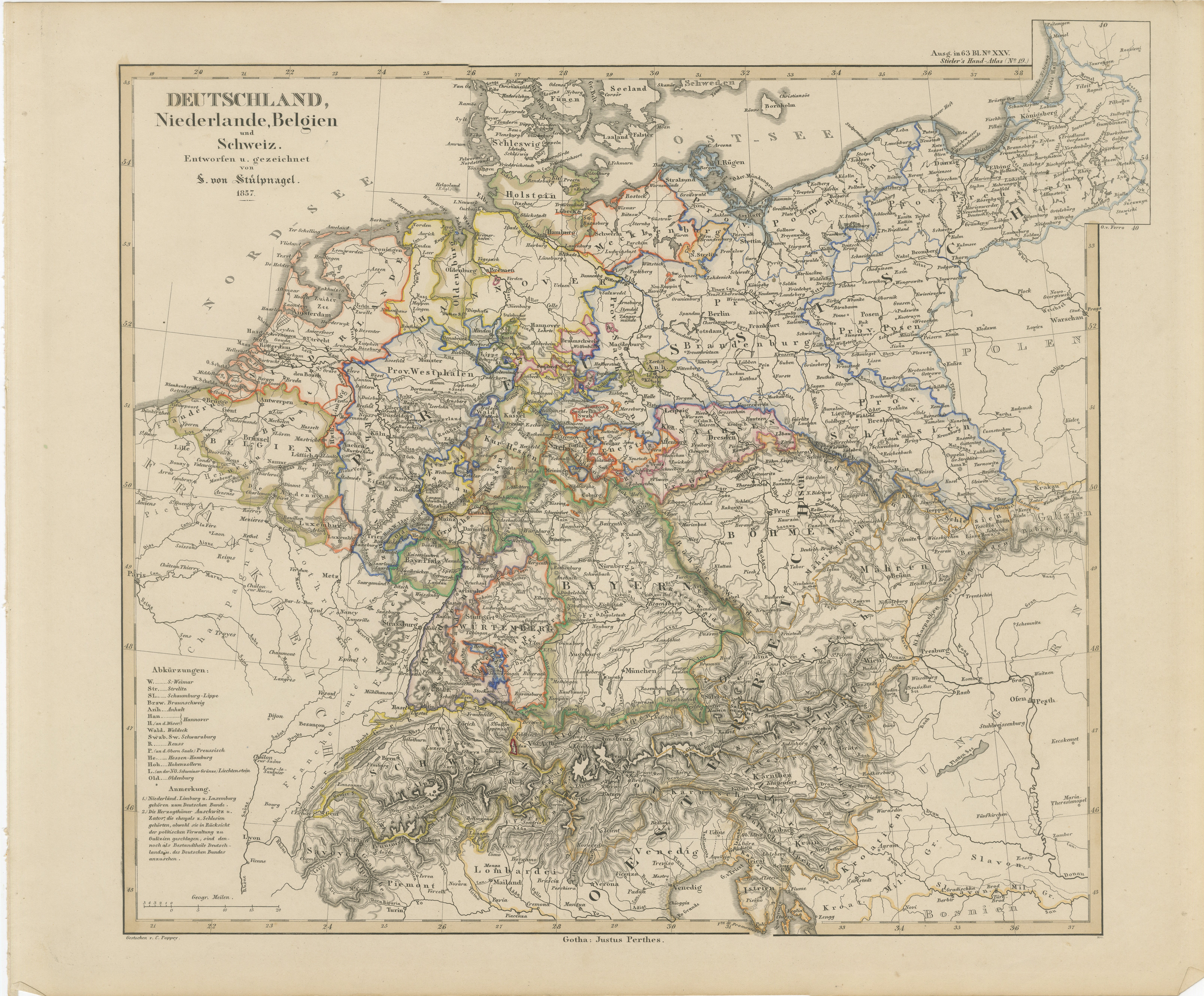
View AllAntique Map of Germany, Netherlands, Belgium & Switzerland – Stülpnagel, 1857
Located in Langweer, NL
Antique Map of Germany, Netherlands, Belgium & Switzerland – Stülpnagel, 1857
Fine mid-19th century map of Central Europe titled "Deutschland, Niederlande, Belgien, Schweiz", drawn ...
Category
Antique Mid-19th Century German Maps
Materials
Paper

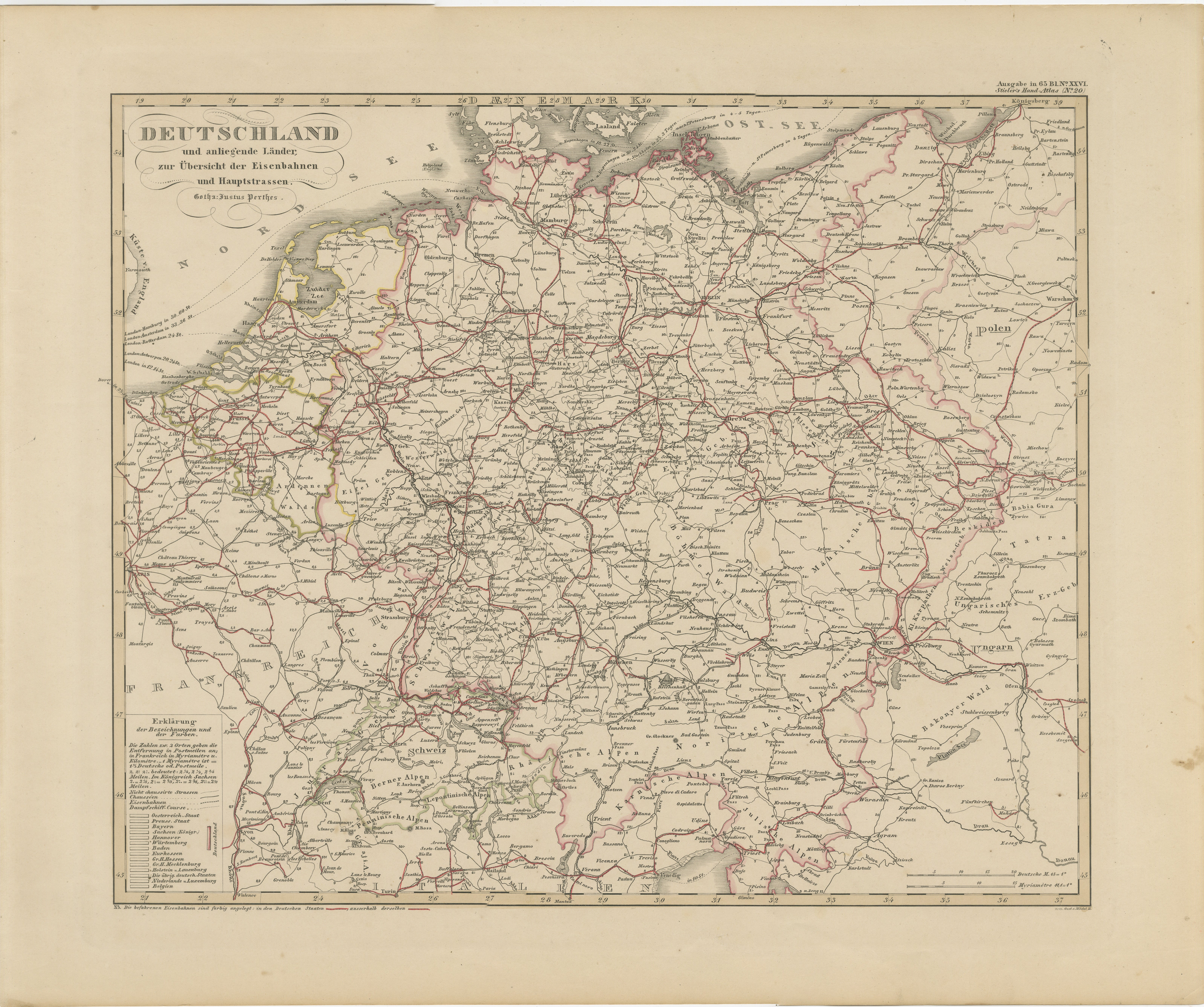
Antique Map of Germany & Railways – Transport Network Overview, 1857
Located in Langweer, NL
Antique Map of Germany & Railways – Transport Network Overview, 1857
Striking 19th-century map titled "Deutschland und angränzende Länder zur Übersicht der Eisenbahnen und Hauptstra...
Category
Antique Mid-19th Century German Maps
Materials
Paper
Antique Map of Belgium and The Netherlands by A.K. Johnston, 1865
Located in Langweer, NL
Antique map titled 'Belgium and The Netherlands'. This map originates from the ‘Royal Atlas of Modern Geography’ by Alexander Keith Johnston. Published by William Blackwood and Sons,...
Category
Antique Mid-19th Century Maps
Materials
Paper
$259 Sale Price
20% Off
Antique Map of Northeastern Germany – Saxon & Prussian States, 1858
Located in Langweer, NL
Antique Map of Northeastern Germany – Saxon & Prussian States, 1858
Detailed and finely engraved map titled "Nord-Östliches Deutschland enthaltend die Sächsischen Länder und die Pre...
Category
Antique Mid-19th Century German Maps
Materials
Paper
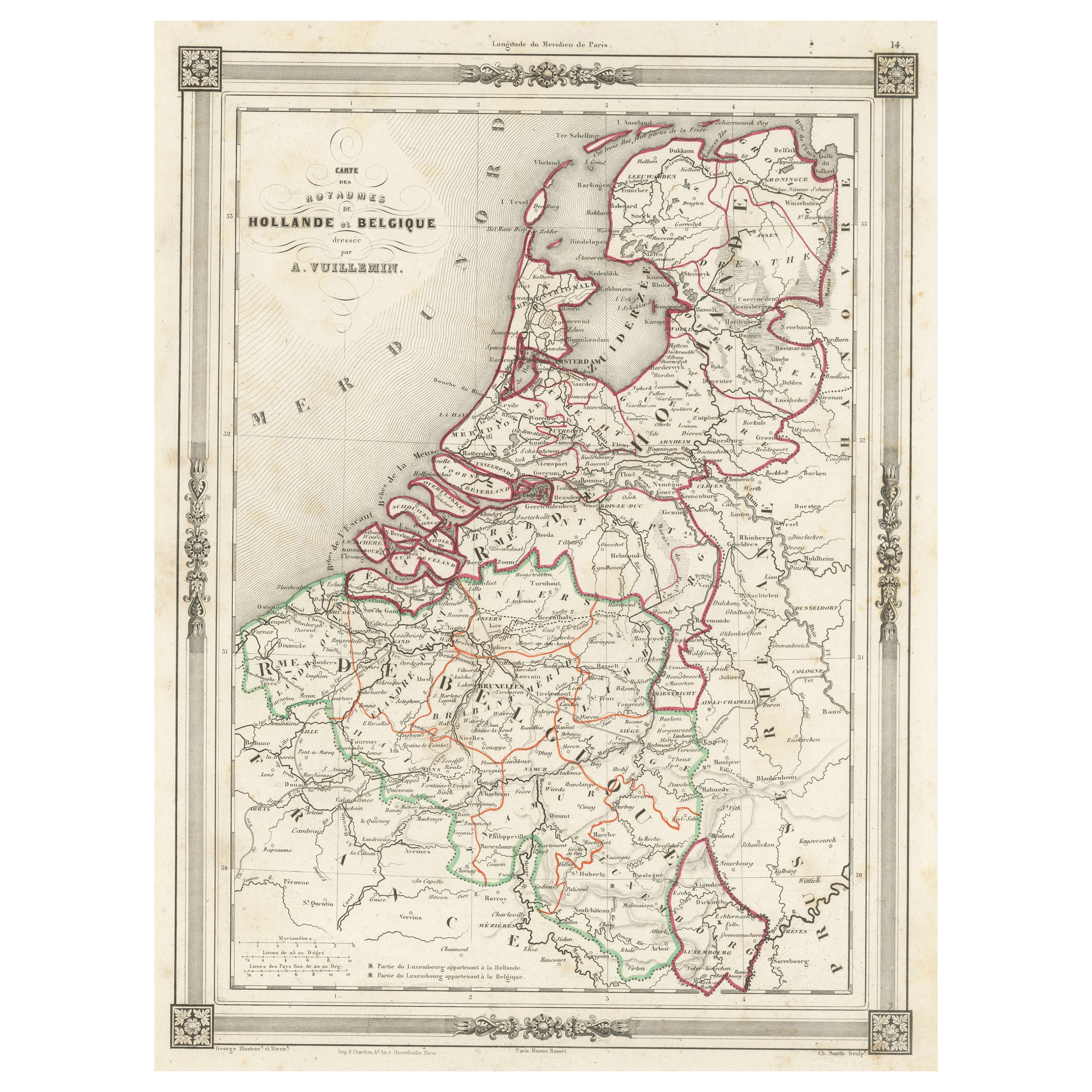
Antique Map of the Netherlands, Belgium and Luxembourg
Located in Langweer, NL
Antique map titled 'Carte des Royaumes Hollande et Belgique'. Attractive map of the Netherlands, Belgium and Luxembourg. This map originates fro...
Category
Antique Mid-19th Century Maps
Materials
Paper
$113 Sale Price
20% Off
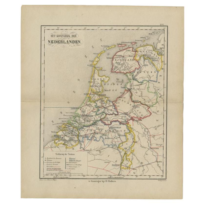
Antique Map of the Netherlands by Brugsma, 1864
Located in Langweer, NL
Antique map titled 'Het Koningrijk der Nederlanden'. Map of the Netherlands. This map originates from 'F. C. Brugsma's Atlas van het Koninkrijk ...
Category
Antique 19th Century Maps
Materials
Paper

$93 Sale Price
20% Off
You May Also Like
The Netherlands (Holland), Belgium and Luxemburg. Century Atlas antique map
Located in Melbourne, Victoria
'The Century Atlas. The Netherlands (Holland), Belgium and Luxemburg.'
Original antique map, 1903.
Inset maps of 'Amsterdam' and 'Brussels'.
Central fold as issued. Map name and num...
Category
Early 20th Century Victorian More Prints
Materials
Lithograph

German Empire, Northern Part. Century Atlas antique vintage map
Located in Melbourne, Victoria
'The Century Atlas. German Empire, Northern Part.'
Original antique map, 1903.
Central fold as issued. Map name and number printed on the reverse corne...
Category
Early 20th Century Victorian More Prints
Materials
Lithograph

German Empire, Southwestern Part. Century Atlas antique vintage map
Located in Melbourne, Victoria
'The Century Atlas. German Empire, Southwestern Part'
Original antique map, 1903.
Central fold as issued. Map name and number printed on the reverse co...
Category
Early 20th Century Victorian More Prints
Materials
Lithograph

1853 Map of "Russia in Europe Including Poland" Ric.r016
Located in Norton, MA
Description
Russia in Europe incl. Poland by J Wyld c.1853
Hand coloured steel engraving
Dimension: Paper: 25 cm W x 33 cm H ; Sight: 22 cm W x 28 cm H
Condition: Good ...
Category
Antique 19th Century Unknown Maps
Materials
Paper

France, Northern Part. Century Atlas antique map
Located in Melbourne, Victoria
'The Century Atlas. France, Northern Part.'
Original antique map, 1903.
Inset maps of 'France in Provinces' and 'Paris and Vicinity'.
Central fold as issued. Map name and number pr...
Category
Early 20th Century Victorian More Prints
Materials
Lithograph

1752 Vaugoundy Map of Flanders : Belgium, France, and the Netherlands, Ric.a002
Located in Norton, MA
Large Vaugoundy Map of Flanders:
Belgium, France, and the Netherlands
Colored -1752
Ric.a002
Description: This is a 1752 Didier Robert de Vaugondy map of Flanders. The map de...
Category
Antique 17th Century Unknown Maps
Materials
Paper
