Items Similar to Antique Map of the region of Trier, Mainz and Cologne, Germany


Want more images or videos?
Request additional images or videos from the seller
1 of 6
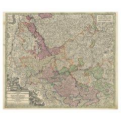
Antique Map of the region of Trier, Mainz and Cologne, Germany
$460.48
$575.6120% Off
£342.55
£428.1920% Off
€384
€48020% Off
CA$630.56
CA$788.2020% Off
A$701.10
A$876.3720% Off
CHF 366.07
CHF 457.5920% Off
MX$8,534.07
MX$10,667.5920% Off
NOK 4,670.95
NOK 5,838.6920% Off
SEK 4,376.46
SEK 5,470.5820% Off
DKK 2,923.18
DKK 3,653.9720% Off
Shipping
Retrieving quote...The 1stDibs Promise:
Authenticity Guarantee,
Money-Back Guarantee,
24-Hour Cancellation
About the Item
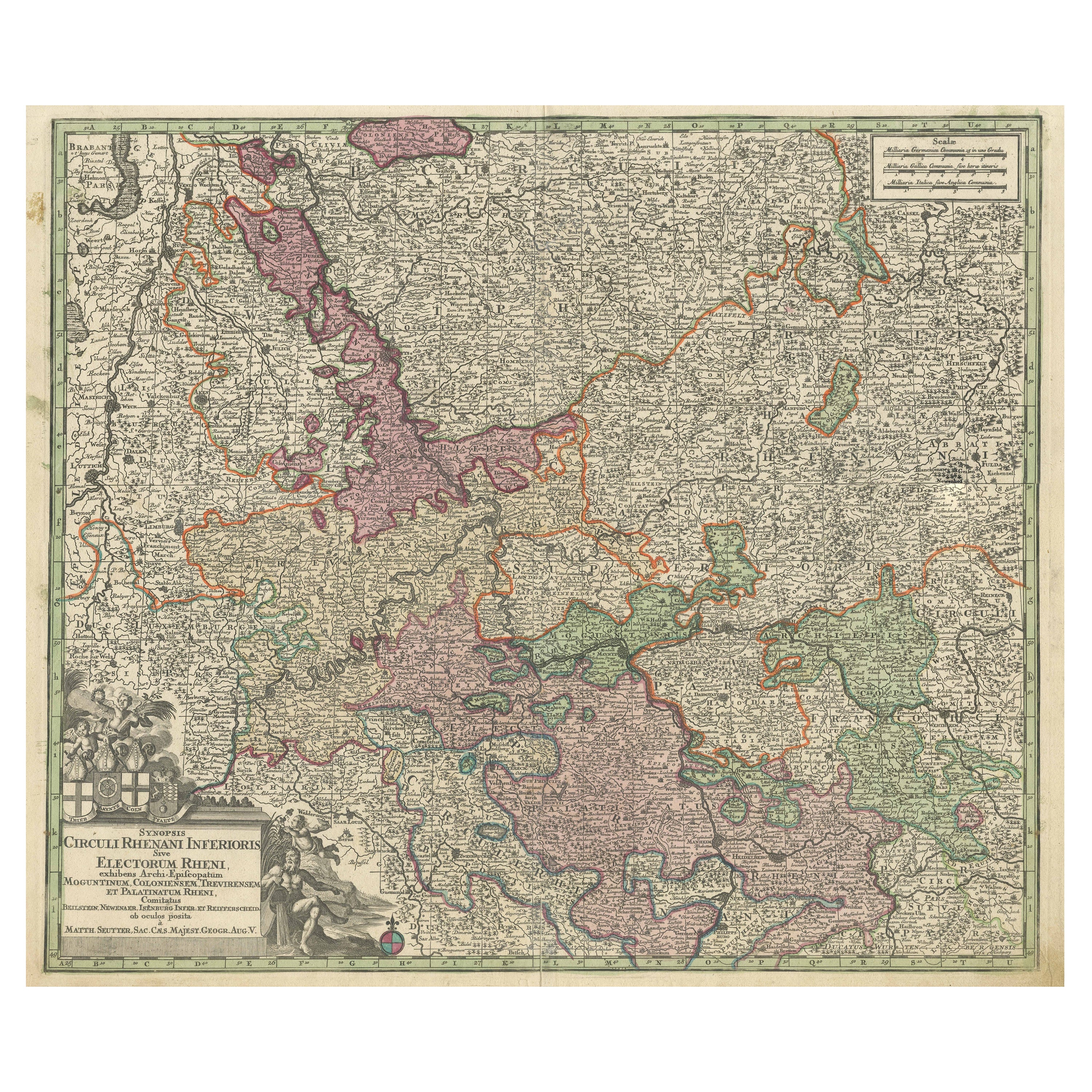
Antique map titled 'Synopsis Circuli Rhenani Inferioris sive Electorum Rheni (..)'. Original antique map of the region of Trier, Mainz and Cologne, Germany. Published by T.C. Lotter, circa 1765. Tobias Conrad Lotter (1717 - 1777) was a German engraver and map publisher.
- Dimensions:Height: 21.58 in (54.8 cm)Width: 26.78 in (68 cm)Depth: 0.02 in (0.5 mm)
- Materials and Techniques:
- Period:
- Date of Manufacture:c.1765
- Condition:Repaired: Folding line with reinforcement. General age-related toning. Minor wear and soiling. Original folding line, with reinforcement. Some manuscript writing in upper margins. Blank verso, almost completely covered in manuscript writing including many names and dates. Please study image.
- Seller Location:Langweer, NL
- Reference Number:Seller: BG-13442-161stDibs: LU3054335045882
About the Seller
5.0
Recognized Seller
These prestigious sellers are industry leaders and represent the highest echelon for item quality and design.
Platinum Seller
Premium sellers with a 4.7+ rating and 24-hour response times
Established in 2009
1stDibs seller since 2017
2,510 sales on 1stDibs
Typical response time: <1 hour
- ShippingRetrieving quote...Shipping from: Langweer, Netherlands
- Return Policy
Authenticity Guarantee
In the unlikely event there’s an issue with an item’s authenticity, contact us within 1 year for a full refund. DetailsMoney-Back Guarantee
If your item is not as described, is damaged in transit, or does not arrive, contact us within 7 days for a full refund. Details24-Hour Cancellation
You have a 24-hour grace period in which to reconsider your purchase, with no questions asked.Vetted Professional Sellers
Our world-class sellers must adhere to strict standards for service and quality, maintaining the integrity of our listings.Price-Match Guarantee
If you find that a seller listed the same item for a lower price elsewhere, we’ll match it.Trusted Global Delivery
Our best-in-class carrier network provides specialized shipping options worldwide, including custom delivery.More From This Seller
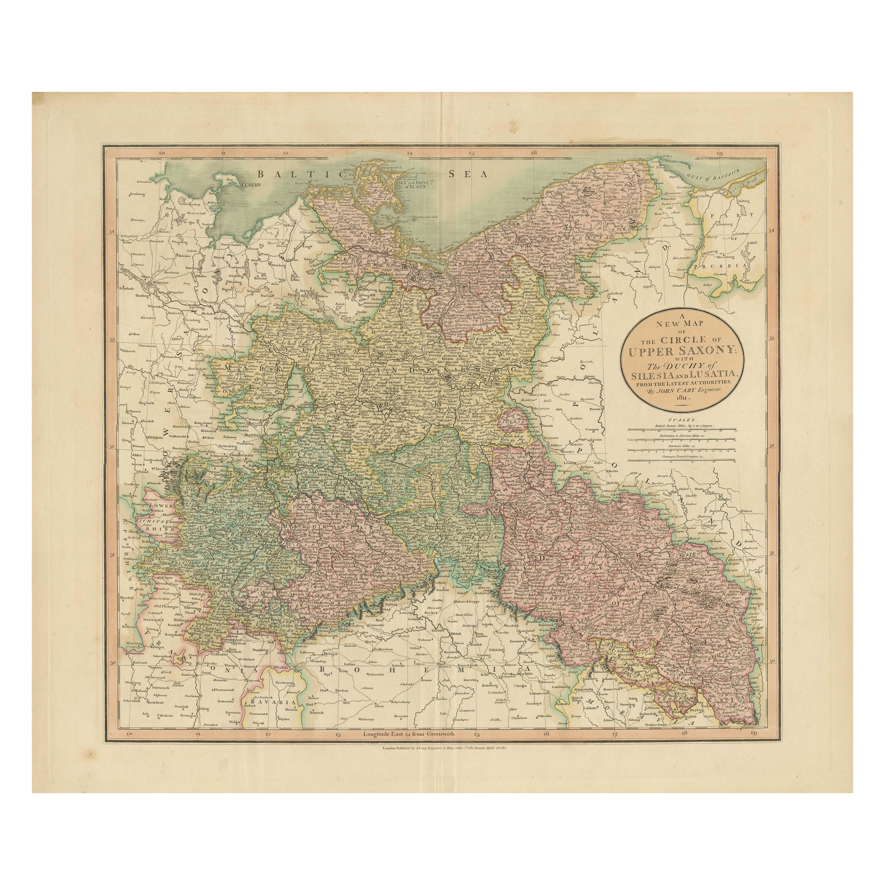
View AllAntique Map of the Eastern Part of Germany, with Parts of Poland and Slovakia
Located in Langweer, NL
Antique map titled 'A New Map of the Circle of Upper Saxony: with the Duchy of Silesi and Lusatia, from the latest authorities'. Clear and accurate map of what is now the eastern par...
Category
Antique Early 19th Century Maps
Materials
Paper
$422 Sale Price
20% Off
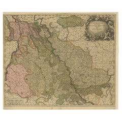
Antique Map of the Course of the Rhine from Philippsburg to Duisburg, Germany
Located in Langweer, NL
Antique map titled 'Synopsis Circuli Rhenani Inferioris sive Electorum Rheni (..)'. This map shows the course of the Rhine from Philippsburg to Duisburg, as well as the course of the...
Category
Antique Mid-18th Century Maps
Materials
Paper
$537 Sale Price
20% Off
Antique Map of Cologne with the duchies of Jülich and Berg, Germany
Located in Langweer, NL
Antique map title 'Archiepiscopatus Coloniensis ducatibus Iuliacensi et Montensi (..)'. Original map of Cologne with the duchies of Jülich and Berg, Spa...
Category
Antique Late 17th Century Maps
Materials
Paper
$450 Sale Price
20% Off
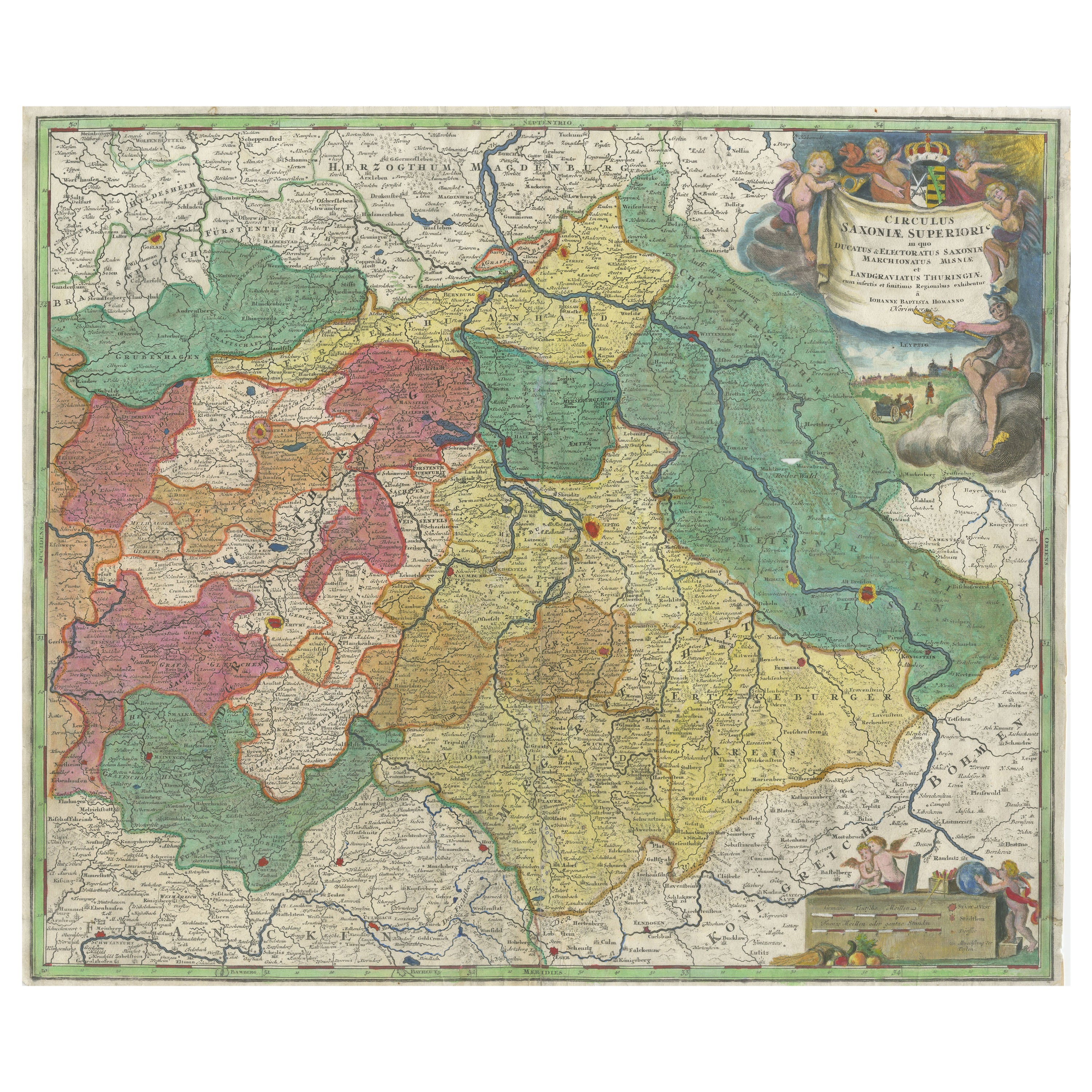
Antique Map of Saxony, Germany
Located in Langweer, NL
Original antique map titled 'Circulus Saxoniae Superioris'. Original antique map of Saxony, Germany. The cities of Leipzig, Freiburg and many others are highlighted in gold. This map originates from 'Atlas Novus Terrarum Orbis...
Category
Antique Early 18th Century Maps
Materials
Paper
$575 Sale Price
20% Off
Antique Map of present-day North-Rhine Westphalia, Germany
Located in Langweer, NL
Antique map titled 'Nova et Accurata Ducatus Cliviae et Comitatus Marchiae (..)'. Detailed regional map of Germany showing the region bounded by the Maas River in the west and to par...
Category
Antique Mid-18th Century Maps
Materials
Paper

$508 Sale Price
20% Off
Antique Map of the Westphalia region of Germany
Located in Langweer, NL
Antique map titled 'Circulus Westphaliae (..)'. Original old map of the Westphalia region, Germany. Published by Justus Danckerts, circa 1696.
Justus Danckerts I (11 November 1635 ...
Category
Antique Late 17th Century Maps
Materials
Paper

You May Also Like
German Empire, Northern Part. Century Atlas antique vintage map
Located in Melbourne, Victoria
'The Century Atlas. German Empire, Northern Part.'
Original antique map, 1903.
Central fold as issued. Map name and number printed on the reverse corne...
Category
Early 20th Century Victorian More Prints
Materials
Lithograph

1853 Map of "Russia in Europe Including Poland" Ric.r016
Located in Norton, MA
Description
Russia in Europe incl. Poland by J Wyld c.1853
Hand coloured steel engraving
Dimension: Paper: 25 cm W x 33 cm H ; Sight: 22 cm W x 28 cm H
Condition: Good ...
Category
Antique 19th Century Unknown Maps
Materials
Paper

German Empire, Southwestern Part. Century Atlas antique vintage map
Located in Melbourne, Victoria
'The Century Atlas. German Empire, Southwestern Part'
Original antique map, 1903.
Central fold as issued. Map name and number printed on the reverse co...
Category
Early 20th Century Victorian More Prints
Materials
Lithograph

17th Century Hand-Colored Map of a Region in West Germany by Janssonius
By Johannes Janssonius
Located in Alamo, CA
This attractive highly detailed 17th century original hand-colored map is entitled "Archiepiscopatus Maghdeburgensis et Anhaltinus Ducatus cum terris adjacentibus". It was published ...
Category
Antique Mid-17th Century Dutch Maps
Materials
Paper

18th Century Hand-Colored Homann Map of Germany, Including Frankfurt and Berlin
By Johann Baptist Homann
Located in Alamo, CA
An 18th century hand-colored map entitled "Tabula Marchionatus Brandenburgici et Ducatus Pomeraniae quae sunt Pars Septentrionalis Circuli Saxoniae Superioris" by Johann Baptist Homa...
Category
Antique Early 18th Century German Maps
Materials
Paper

Original Antique English County Map, Nottinghamshire, J & C Walker, 1851
Located in St Annes, Lancashire
Great map of Nottinghamshire
Original colour
By J & C Walker
Published by Longman, Rees, Orme, Brown & Co. 1851
Unframed.
Category
Antique 1850s English Other Maps
Materials
Paper

More Ways To Browse
Tobias Antique
1681 Moses Pitt
Antique Maps Washington Dc
Ithaca Antique Map
J Thayer
Rust Red Rug
Vintage Studio Chair
1890s French Posters
Casa Finland
Mobelfabrik Danish
Playful Chair
Giacometti Chairs
Antique Rug Wool Navy Blue Red
Bauhaus Flower Stand
French Table With Drawers
North Carolina Furniture
Antique Silver Platter
Boat Blueprint