Items Similar to Antique Map of the Rhineland and Alsace Region with Original Hand Coloring


Want more images or videos?
Request additional images or videos from the seller
1 of 6
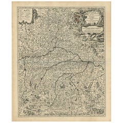
Antique Map of the Rhineland and Alsace Region with Original Hand Coloring
$297.40
$371.7520% Off
£221.23
£276.5420% Off
€248
€31020% Off
CA$407.24
CA$509.0520% Off
A$452.79
A$565.9920% Off
CHF 236.42
CHF 295.5320% Off
MX$5,511.59
MX$6,889.4820% Off
NOK 3,016.66
NOK 3,770.8220% Off
SEK 2,826.46
SEK 3,533.0820% Off
DKK 1,887.89
DKK 2,359.8620% Off
Shipping
Retrieving quote...The 1stDibs Promise:
Authenticity Guarantee,
Money-Back Guarantee,
24-Hour Cancellation
About the Item
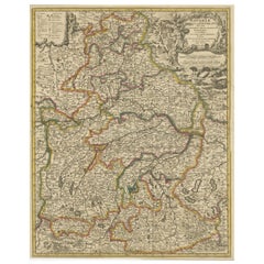
Antique map titled 'Palitinat du Rhein, Alsace, et partie de Souabe de Franconie (..)'. Double-page engraved map of the Rhineland and Alsace with original/contemporary hand coloring. Published by N. Sanson, circa 1648.
Nicolas Sanson (1600-1667) sometimes called Nicolas Sanson d'Abbeville or Sanson d'Abbeville, was the most important French cartographer of the 17th century. Tooley called Sanson "the founder of the French school of cartography." He began making maps in the late 1620s, and in the 1630s he was working with Melchior Tavernier. Later, Sanson worked in concert with the print publisher Pierre Mariette, with whom he published his great atlas: Cartes générales de toutes les parties du monde (1658). After Sanson's death in 1667, his son Guillaume carried on the business in partnership with Alexis Hubert Jaillot. Guillaume established himself as a very important French mapmaker in his own right.
- Dimensions:Height: 16.93 in (43 cm)Width: 22.45 in (57 cm)Depth: 0.02 in (0.5 mm)
- Materials and Techniques:
- Period:Mid-17th Century
- Date of Manufacture:c.1648
- Condition:Original folding line. Original/contemporary hand coloring. Shows some wear and soiling. Spots in upper margin, also a few very tiny holes. Blank verso. Please study image carefully.
- Seller Location:Langweer, NL
- Reference Number:Seller: BG-13397-211stDibs: LU3054333827232
About the Seller
5.0
Recognized Seller
These prestigious sellers are industry leaders and represent the highest echelon for item quality and design.
Platinum Seller
Premium sellers with a 4.7+ rating and 24-hour response times
Established in 2009
1stDibs seller since 2017
2,511 sales on 1stDibs
Typical response time: <1 hour
- ShippingRetrieving quote...Shipping from: Langweer, Netherlands
- Return Policy
Authenticity Guarantee
In the unlikely event there’s an issue with an item’s authenticity, contact us within 1 year for a full refund. DetailsMoney-Back Guarantee
If your item is not as described, is damaged in transit, or does not arrive, contact us within 7 days for a full refund. Details24-Hour Cancellation
You have a 24-hour grace period in which to reconsider your purchase, with no questions asked.Vetted Professional Sellers
Our world-class sellers must adhere to strict standards for service and quality, maintaining the integrity of our listings.Price-Match Guarantee
If you find that a seller listed the same item for a lower price elsewhere, we’ll match it.Trusted Global Delivery
Our best-in-class carrier network provides specialized shipping options worldwide, including custom delivery.More From This Seller
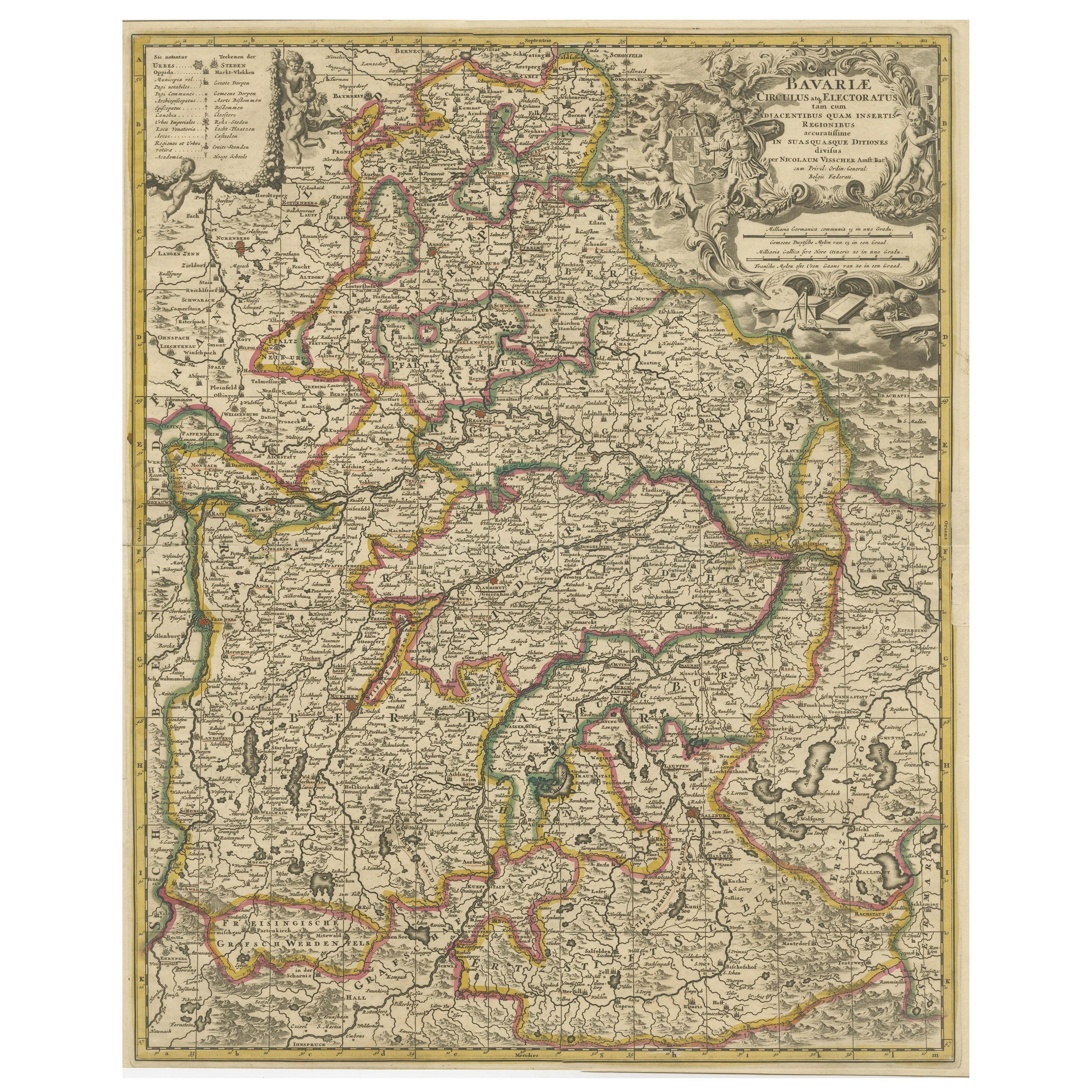
View AllAntique Map of Bavaria, Bayern, with original Hand Coloring
Located in Langweer, NL
Antique map titled 'Bavariae Circulus atq Electoratus tam cum Adiacentibus quam insertis Regionibus'. Original old map of Bavaria, Bayern, Germany. The map stretches south to Innsbru...
Category
Antique Late 17th Century Maps
Materials
Paper
$450 Sale Price
20% Off
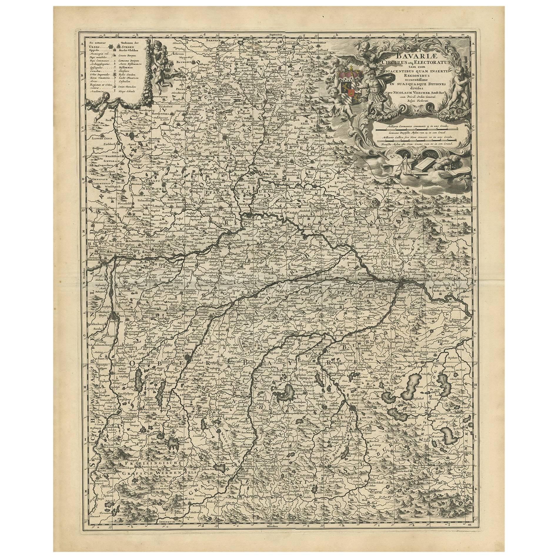
Antique Map of Bavaria with many details, Germany
Located in Langweer, NL
Antique map titled 'Bavariae Circulus atq Electoratus tam cum Adiacentibus quam insertis Regionibus (..)'. Dutch map of Bavaria, showing the many cities, towns, and other features of...
Category
Antique Late 17th Century Maps
Materials
Paper
$633 Sale Price
20% Off
Antique Map of present-day North-Rhine Westphalia, Germany
Located in Langweer, NL
Antique map titled 'Nova et Accurata Ducatus Cliviae et Comitatus Marchiae (..)'. Detailed regional map of Germany showing the region bounded by the Maas River in the west and to par...
Category
Antique Mid-18th Century Maps
Materials
Paper

$508 Sale Price
20% Off
Antique Map of the Alsace Region of France by Schenk 'circa 1700'
Located in Langweer, NL
Antique map titled 'Superioris atque Inferioris Alsatiae'. Beautiful map of the Alsace region, from Basel in the south to Philipsburg in the north, centered on Strassburg. Published ...
Category
Antique Early 18th Century Maps
Materials
Paper

$575 Sale Price
20% Off
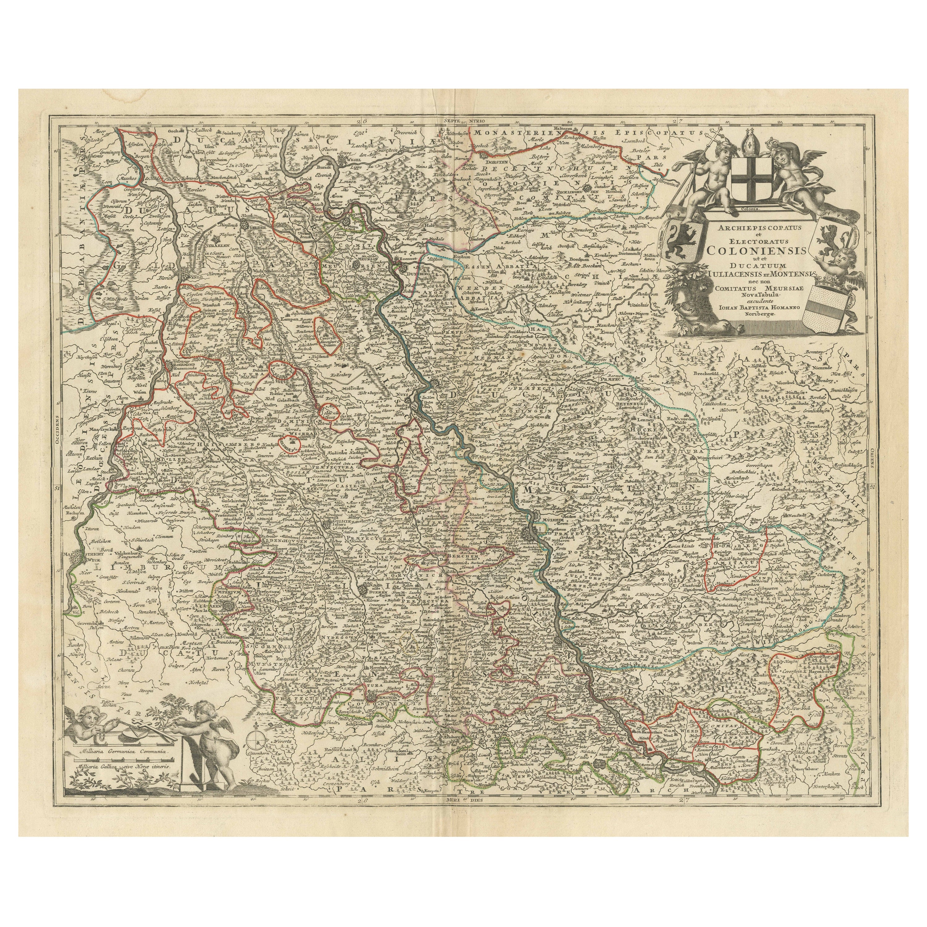
Antique Map of the Rhine centered on Cologne, Germany, with outline coloring
Located in Langweer, NL
Antique map titled 'Archiepsiscopatus et Electoratus Coloniensis (..)'. Original antique map of the Rhine river, centered on Cologne, Germany. The Rhine River cuts across this map fr...
Category
Antique Early 18th Century Maps
Materials
Paper

$460 Sale Price
20% Off
Antique Map of the Niederrhein region, Germany
Located in Langweer, NL
Antique map titled 'Circulus Electorum Rheni sive Rhenanus Inferior (..)'. Original antique map of the Niederrhein region, Germany. By F. de Wit, circa 1690.
Frederick de Wit (1629-...
Category
Antique Late 17th Century Maps
Materials
Paper
$431 Sale Price
20% Off
You May Also Like
17th Century Hand-Colored Map of a Region in West Germany by Janssonius
By Johannes Janssonius
Located in Alamo, CA
This attractive highly detailed 17th century original hand-colored map is entitled "Archiepiscopatus Maghdeburgensis et Anhaltinus Ducatus cum terris adjacentibus". It was published ...
Category
Antique Mid-17th Century Dutch Maps
Materials
Paper

18th Century Hand-Colored Homann Map of Germany, Including Frankfurt and Berlin
By Johann Baptist Homann
Located in Alamo, CA
An 18th century hand-colored map entitled "Tabula Marchionatus Brandenburgici et Ducatus Pomeraniae quae sunt Pars Septentrionalis Circuli Saxoniae Superioris" by Johann Baptist Homa...
Category
Antique Early 18th Century German Maps
Materials
Paper

Prussia, Poland, N. Germany, Etc: A Hand-colored 17th Century Map by Janssonius
By Johannes Janssonius
Located in Alamo, CA
This is an attractive hand-colored copperplate engraved 17th century map of Prussia entitled "Prussia Accurate Descripta a Gasparo Henneberg Erlichensi", published in Amsterdam by Joannes Janssonius in 1664. This very detailed map from the golden age of Dutch cartography includes present-day Poland, Latvia, Lithuania, Estonia and portions of Germany. This highly detailed map is embellished by three ornate pink, red, mint green and gold...
Category
Antique Mid-17th Century Dutch Maps
Materials
Paper

Hand Colored 18th Century Homann Map of Austria Including Vienna and the Danube
By Johann Baptist Homann
Located in Alamo, CA
"Archiducatus Austriae inferioris" is a hand colored map of Austria created by Johann Baptist Homann (1663-1724) and published in Nuremberg, Germany in 1728 shortly after his death. ...
Category
Antique Early 18th Century German Maps
Materials
Paper

Antique Colored Belgium Map Flandria Gallica Flanders Henricus Hondius
Located in Dayton, OH
Antique hand colored map of Flanders, Belgium, engraved by Henricus Hondius.
Sans frame - 21.25” x 18”.
Category
Antique 19th Century Renaissance Maps
Materials
Paper

$280 Sale Price
20% Off
17th Century Hand Colored Map of the Liege Region in Belgium by Visscher
By Nicolaes Visscher II
Located in Alamo, CA
An original 17th century map entitled "Leodiensis Episcopatus in omnes Subjacentes Provincias distincté divisusVisscher, Leodiensis Episcopatus" by Nicolaes Visscher II, published in Amsterdam in 1688. The map is centered on Liege, Belgium, includes the area between Antwerp, Turnhout, Roermond, Cologne, Trier and Dinant.
This attractive map is presented in a cream-colored mat measuring 30" wide x 27.5" high. There is a central fold, as issued. There is minimal spotting in the upper margin and a tiny spot in the right lower margin, which are under the mat. The map is otherwise in excellent condition.
The Visscher family were one of the great cartographic families of the 17th century. Begun by Claes Jansz Visscher...
Category
Antique Late 17th Century Dutch Maps
Materials
Paper
