Items Similar to Antique Map of South America with Many Details, ca.1859


Want more images or videos?
Request additional images or videos from the seller
1 of 6
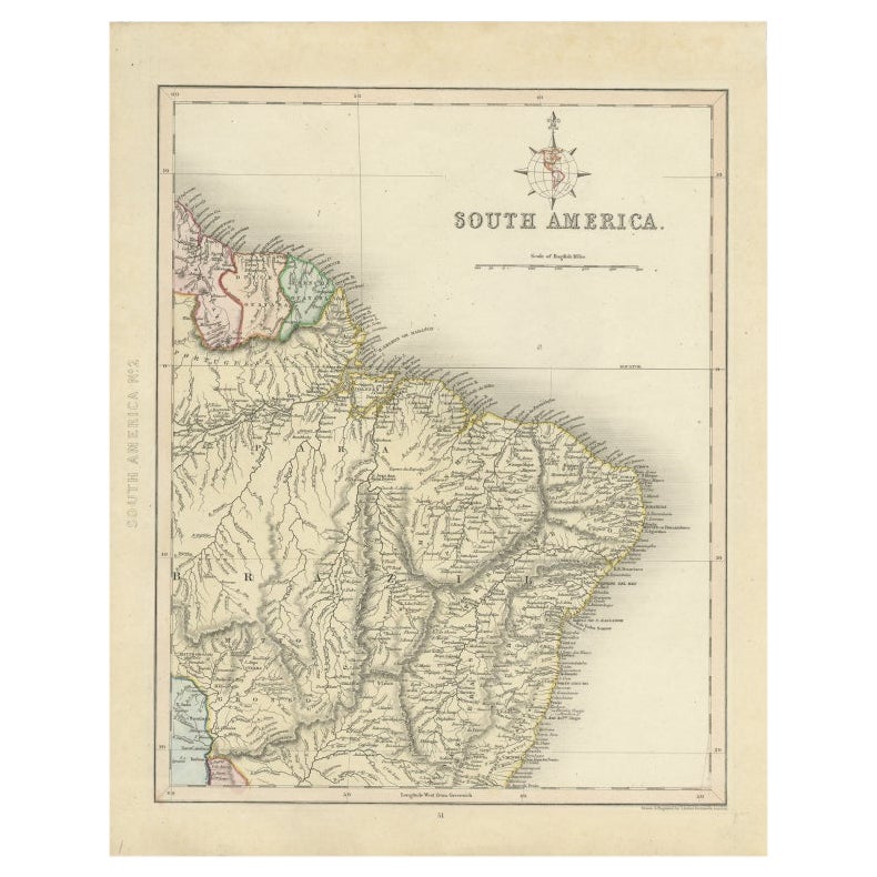
Antique Map of South America with Many Details, ca.1859
$556.42
$695.5220% Off
£413.92
£517.4020% Off
€464
€58020% Off
CA$761.93
CA$952.4120% Off
A$847.16
A$1,058.9520% Off
CHF 442.34
CHF 552.9320% Off
MX$10,312
MX$12,89020% Off
NOK 5,644.07
NOK 7,055.0920% Off
SEK 5,288.22
SEK 6,610.2820% Off
DKK 3,532.18
DKK 4,415.2220% Off
Shipping
Retrieving quote...The 1stDibs Promise:
Authenticity Guarantee,
Money-Back Guarantee,
24-Hour Cancellation
About the Item
Original antique map titled 'Süd-America'. Beautiful old map of South America, with many details and legend.
This map originates from Stielers Handatlas, published circa 1859. Stielers Handatlas (after Adolf Stieler, 1775–1836), formally titled Hand-Atlas über alle Theile der Erde und über das Weltgebäude (Handy atlas of all parts of the world and of the universe), was the leading German world atlas of the last three decades of the 19th and the first half of the 20th century. Published by Justus Perthes of Gotha (established 1785 and still existing there) it went through ten editions from 1816 to 1945. As with many 19th century publications, an edition was issued in parts; for example, the eighth edition was issued in 32 monthly parts.
- Dimensions:Height: 14.69 in (37.3 cm)Width: 17.8 in (45.2 cm)Depth: 0.02 in (0.5 mm)
- Materials and Techniques:
- Period:
- Date of Manufacture:circa 1859
- Condition:Wear consistent with age and use. General age-related toning, minor wear and foxing. Blank verso. Please study images carefully.
- Seller Location:Langweer, NL
- Reference Number:Seller: BG-13190-101stDibs: LU3054331370522
About the Seller
5.0
Recognized Seller
These prestigious sellers are industry leaders and represent the highest echelon for item quality and design.
Platinum Seller
Premium sellers with a 4.7+ rating and 24-hour response times
Established in 2009
1stDibs seller since 2017
2,511 sales on 1stDibs
Typical response time: <1 hour
- ShippingRetrieving quote...Shipping from: Langweer, Netherlands
- Return Policy
Authenticity Guarantee
In the unlikely event there’s an issue with an item’s authenticity, contact us within 1 year for a full refund. DetailsMoney-Back Guarantee
If your item is not as described, is damaged in transit, or does not arrive, contact us within 7 days for a full refund. Details24-Hour Cancellation
You have a 24-hour grace period in which to reconsider your purchase, with no questions asked.Vetted Professional Sellers
Our world-class sellers must adhere to strict standards for service and quality, maintaining the integrity of our listings.Price-Match Guarantee
If you find that a seller listed the same item for a lower price elsewhere, we’ll match it.Trusted Global Delivery
Our best-in-class carrier network provides specialized shipping options worldwide, including custom delivery.More From This Seller
View AllAntique Map of South America, c.1840
Located in Langweer, NL
Antique map titled 'South America'. Original, antique map depicting South America. With outline coloring. Source unknown, to be determined. Artists and Engravers: Anonymous.
Artist:...
Category
Antique 19th Century Maps
Materials
Paper

$70 Sale Price
20% Off
Antique Map of Part of South America by Archer, C.1860
Located in Langweer, NL
Antique map titled 'South America'. This antique map depicts the north-east of South America, including a large part of Brazil. Artists and Engravers: Drawn and engraved by J. Archer...
Category
Antique 19th Century Maps
Materials
Paper
$91 Sale Price
20% Off
Antique Map of South America by A & C. Black, 1870
Located in Langweer, NL
Antique map titled 'South America'. Original antique map of Map of South America. This map originates from ‘Black's General Atlas of The World’. Published by A & C. Black, 1870.
Category
Antique Late 19th Century Maps
Materials
Paper

$263 Sale Price
20% Off
Antique Map of South America by Dower, ‘circa 1845’
Located in Langweer, NL
Antique map titled 'South America'. Old map of South America. Published by Orr & Company, Amen Corner, Paternoster Row, London.
Category
Antique Mid-19th Century Maps
Materials
Paper

$143 Sale Price
20% Off
Antique Map of South America ‘North’ by A.K. Johnston, 1865
Located in Langweer, NL
Antique map titled 'South America, Northern Sheet'. Depicting Guiana, Ecuador, Brazil, Bolivia the Amazones and more. This map originates from the ‘Royal Atlas of Modern Geography’ b...
Category
Antique Mid-19th Century Maps
Materials
Paper

$263 Sale Price
20% Off
Antique Map of South America by W. G. Blackie, 1859
Located in Langweer, NL
Antique map titled 'South America'. Original antique map of South America. This map originates from ‘The Imperial Atlas of Modern Geography’. Published by W. G. Blackie, 1859.
Category
Antique Mid-19th Century Maps
Materials
Paper

$239 Sale Price
20% Off
You May Also Like
South America, Eastern Part. Century Atlas antique vintage map
Located in Melbourne, Victoria
'The Century Atlas. South America. Eastern Part'
Original antique map, 1903.
Inset map 'Rio de Janeiro and Vicinity'.
Central fold as issued. Map name and number printed on the rev...
Category
Early 20th Century Victorian More Prints
Materials
Lithograph

Antique Lithography Map, South America, English, Framed, Cartography, Victorian
Located in Hele, Devon, GB
This is an antique lithography map of South America. An English, framed atlas engraving of cartographic interest by John Rapkin , dating to the early Victorian period and later, circ...
Category
Antique Mid-19th Century British Early Victorian Maps
Materials
Wood

Antique Map of South America in Roma Frame
Located in Malibu, CA
Antique map of South America. Displayed in a new Roma frame with museum quality matting. Custom frame in platinum. No print date, but cert...
Category
Antique Late 19th Century Victorian Prints
Materials
Hardwood, Paper

$262 Sale Price
30% Off
South America, North-West Part. Century Atlas antique vintage map
Located in Melbourne, Victoria
'The Century Atlas. South America, North-West Part'
Original antique map, 1903.
Central fold as issued. Map name and number printed on the reverse corners.
Sheet 40cm by 29.5cm.
Category
Early 20th Century Victorian More Prints
Materials
Lithograph

Original Antique Map of South America. C.1780
Located in St Annes, Lancashire
Great map of South America
Copper-plate engraving
Published C.1780
Two small worm holes to left side of map
Unframed.
Category
Antique Early 1800s English Georgian Maps
Materials
Paper

Original Antique Decorative Map of South America-West Coast, Fullarton, C.1870
Located in St Annes, Lancashire
Great map of Chili, Peru and part of Bolivia
Wonderful figural border
From the celebrated Royal Illustrated Atlas
Lithograph. Original color.
Published by Fullarton, Edi...
Category
Antique 1870s Scottish Maps
Materials
Paper

More Ways To Browse
Antique Map Of Cornwall
Coronelli Globe
Vintage Bartholomew Maps
Antique Alabama Map
Cape Cod Map
Goa France
Antique Planisphere
Charlotte Reine
Dutch Malacca
Gabon Antique Map
J And C Bavaria
Map Of Barbados
Montreal Map
Antique Furniture Toledo Ohio
Laos Antique Map
Orinoco Furniture
Johann Baptist Homann On Sale
Rand Mcnally Vintage Maps