Items Similar to Antique Map of Stavoren by Coronelli, 1706
Want more images or videos?
Request additional images or videos from the seller
1 of 5
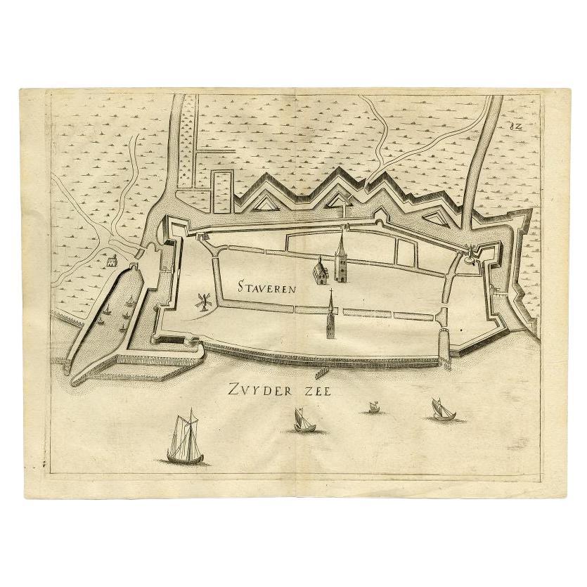
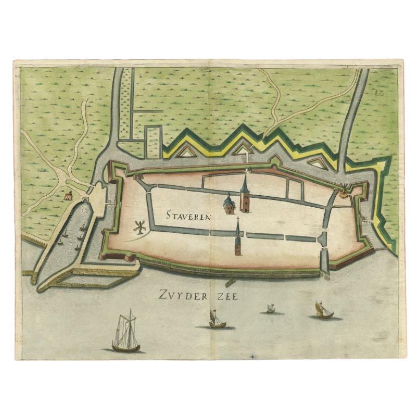
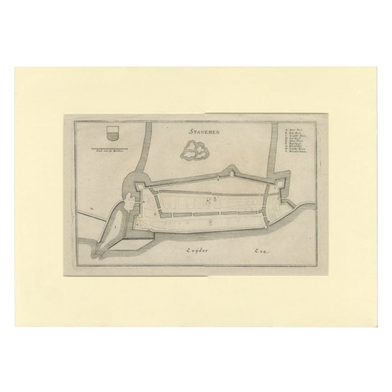
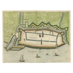
Antique Map of Stavoren by Coronelli, 1706
$108.31
$135.3920% Off
£80.62
£100.7720% Off
€90.40
€11320% Off
CA$148.36
CA$185.4520% Off
A$165.01
A$206.2620% Off
CHF 86.16
CHF 107.7020% Off
MX$2,007.99
MX$2,509.9920% Off
NOK 1,100.43
NOK 1,375.5420% Off
SEK 1,032.01
SEK 1,290.0120% Off
DKK 688.18
DKK 860.2320% Off
Shipping
Retrieving quote...The 1stDibs Promise:
Authenticity Guarantee,
Money-Back Guarantee,
24-Hour Cancellation
About the Item
Antique map titled 'Staveren'. Rare antique map of the city of Stavoren, Friesland, the Netherlands. This map originates from 'Teatro della Guerra' by P. Coronelli, 1706. Artists and Engravers: Corronelli was a Franciscan priest, who spend most of his life in Venice. He was a noted theologian and was appointed as Father General of his order in 1699. At that time he was already famous as a mathematician, cartographer and globe maker. He was very infuential, compiled and engraved over 500 maps. His most well known work is the 2-volume 'Atlante Veneto' but is is equally well known for his very large terrestrial and celestial globes. One, 15 feet in diameter he made for Louis XIV of France.
Artist: Corronelli was a Franciscan priest, who spend most of his life in Venice. He was a noted theologian and was appointed as Father General of his order in 1699. At that time he was already famous as a mathematician, cartographer and globe maker. He was very infuential, compiled and engraved over 500 maps. His most well known work is the 2-volume 'Atlante Veneto' but is is equally well known for his very large terrestrial and celestial globes. One, 15 feet in diameter he made for Louis XIV of France.
Condition: Very good, given age. Right margin reinforced using contemporary paper backed with acid free archival tape. General age-related toning and/or occasional minor defects from handling. Please study scan carefully.
Date: 1706
Overall size: 11.8 x 18 cm.
Image size: 0.001 x 8.7 x 12.7 cm.
Antique prints have long been appreciated for both their aesthetic and investment value. They were the product of engraved, etched or lithographed plates. These plates were handmade out of wood or metal, which required an incredible level of skill, patience and craftsmanship. Whether you have a house with Victorian furniture or more contemporary decor an old engraving can enhance your living space. We offer a wide range of authentic antique prints for any budget.
- Dimensions:Height: 7.09 in (18 cm)Width: 4.65 in (11.8 cm)Depth: 0 in (0.01 mm)
- Materials and Techniques:
- Period:
- Date of Manufacture:1706
- Condition:
- Seller Location:Langweer, NL
- Reference Number:Seller: PCT-485191stDibs: LU3054327771302
About the Seller
5.0
Recognized Seller
These prestigious sellers are industry leaders and represent the highest echelon for item quality and design.
Platinum Seller
Premium sellers with a 4.7+ rating and 24-hour response times
Established in 2009
1stDibs seller since 2017
2,508 sales on 1stDibs
Typical response time: <1 hour
- ShippingRetrieving quote...Shipping from: Langweer, Netherlands
- Return Policy
Authenticity Guarantee
In the unlikely event there’s an issue with an item’s authenticity, contact us within 1 year for a full refund. DetailsMoney-Back Guarantee
If your item is not as described, is damaged in transit, or does not arrive, contact us within 7 days for a full refund. Details24-Hour Cancellation
You have a 24-hour grace period in which to reconsider your purchase, with no questions asked.Vetted Professional Sellers
Our world-class sellers must adhere to strict standards for service and quality, maintaining the integrity of our listings.Price-Match Guarantee
If you find that a seller listed the same item for a lower price elsewhere, we’ll match it.Trusted Global Delivery
Our best-in-class carrier network provides specialized shipping options worldwide, including custom delivery.More From This Seller
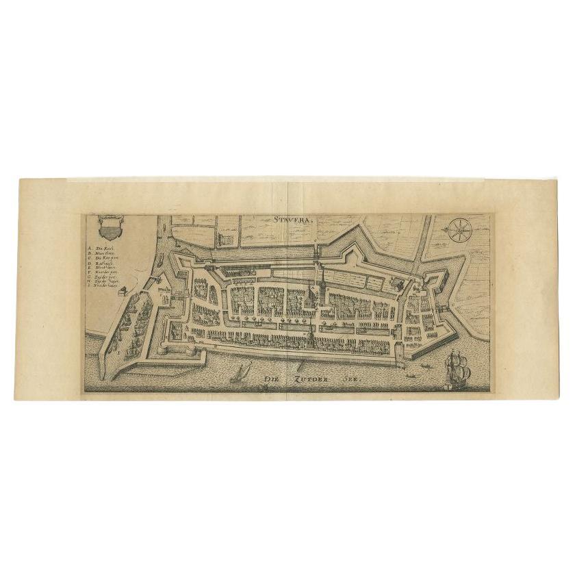
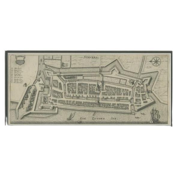
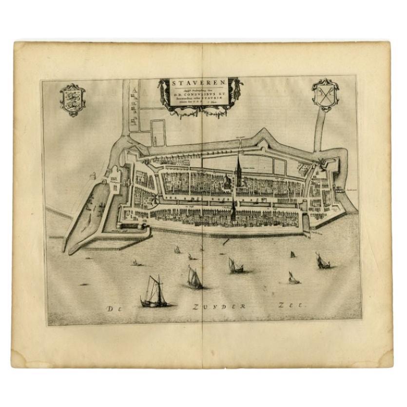
View AllAntique Map of Stavoren by Priorato, 1673
Located in Langweer, NL
Antique map titled 'Staveren'. Original antique map of the city of Stavoren, Friesland, the Netherlands. This map orginates from 'Teatro del Belgio (..)', published in Frankfurt am Main in 1673 by Gualdo Priorato. Artists and Engravers: Author: Galeazzo Gualdo Priorato (1606-1678) entered military service at a very young age and served in Flanders under the Prince of Orange. After his retirement, he authored several historical accounts including the Teatro del Belgio, which described the Catholic/Protestant wars in Belgium and Netherlands during the seventeenth century. His superb plans do not show the internal layout of the cities, except for showing the locations of the major churches. Instead the emphasis is on the fortification, as well as on the surrounding site, rivers and canals...
Category
Antique 17th Century Maps
Materials
Paper
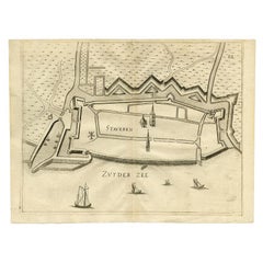
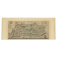
Antique Map of Stavoren by Merian, c.1650
Located in Langweer, NL
Antique map titled 'Stavera'. Map of the city of Stavoren, Friesland. With German legend. Trimmed, originally published on one sheet with a map of Bolsward and Hindeloopen. Artists a...
Category
Antique 17th Century Maps
Materials
Paper
$134 Sale Price
20% Off
Antique Map of Stavoren by Priorato, 1673
Located in Langweer, NL
Antique map titled 'Staveren'. Original antique map of the city of Stavoren, Friesland, the Netherlands. This map orginates from 'Teatro del Belgio (..)', published in Frankfurt am Main in 1673 by Gualdo Priorato. Artists and Engravers: Author: Galeazzo Gualdo Priorato (1606-1678) entered military service at a very young age and served in Flanders under the Prince of Orange. After his retirement, he authored several historical accounts including the Teatro del Belgio, which described the Catholic/Protestant wars in Belgium and Netherlands during the seventeenth century. His superb plans do not show the internal layout of the cities, except for showing the locations of the major churches. Instead the emphasis is on the fortification, as well as on the surrounding site, rivers and canals...
Category
Antique 17th Century Maps
Materials
Paper
$158 Sale Price
20% Off
Antique Map of Stavoren by Merian, c.1650
Located in Langweer, NL
Antique map titled 'Stavera'. Map of the city of Stavoren, Friesland. With German legend. Trimmed, originally published on one sheet with a map of Bolsward and Hindeloopen. Artists a...
Category
Antique 17th Century Maps
Materials
Paper
$156 Sale Price
20% Off
Antique Map of the City of Stavoren by Merian, 1659
Located in Langweer, NL
Antique map titled 'Staveren'. Original antique map of the city of Stavoren, Friesland, the Netherlands. This map originates from 'Topographia Germania Inferioris' by C. Merian. Publ...
Category
Antique 17th Century Maps
Materials
Paper
$148 Sale Price
20% Off
Antique Map of Stavoren by Blaeu, 1649
Located in Langweer, NL
Antique map titled 'Staveren'. Original antique map of the city of Stavoren, Friesland, The Netherlands. This map originates from 'Toonneel der Steden van de Vereenighde Nederlanden'...
Category
Antique 17th Century Maps
Materials
Paper
$333 Sale Price
20% Off
You May Also Like
18th Century Map Engraving - Newport, a Strong Sea-Port Town in Flanders
Located in Corsham, GB
A map of Nieuwpoort, anglicised to 'Newport', in northern Belgium. There is a panorama in the upper quarter depicting major landmarks. Below is a plan of the town, including its strong defences and ships at the port in the lower register. Inscribed with the title in plate to the lower edge, 'Newport a Strong Sea-Port Town...
Category
18th Century More Prints
Materials
Engraving

$269 Sale Price
20% Off
17th Century Toulouse, Savve, Sommieres Topographical Map by Iohan Peeters
Located in New York, NY
Fine topographical 17th century map of Toulouse, Savve and Sommieres by Iohan Peeters
Beautiful engraving of the capital of France's Occitanie Region, Toulouse, called La Ville Rose- the Pink City, for the terracotta bricks used in its many buildings, giving the city a distinct apricot-rose hue. An important cultural and educational center, the city's residents included Nobel Prize winners and world renown artists- Henri de Toulouse-Lautrec, Henri Martin, Jean-Auguste-Dominique Ingres, Antonin Mercie, Alexandre Falguiere and more recently Cyril Kongo...
Category
Antique 17th Century Dutch Maps
Materials
Paper

Original Antique Map or City Plan of Amsterdam, Netherlands. Circa 1835
Located in St Annes, Lancashire
Nice map of Amsterdam
Drawn and engraved by J.Dower
Published by Orr & Smith. C.1835
Unframed.
Free shipping
Category
Antique 1830s English Maps
Materials
Paper

17th-18th Century Siege of Graves Mapping Engraving By Willian III
Located in Kingston, NY
RARE French 17th-18th Century Enhanced Siege of Graves Mapping Engraving BY William III, also widely known as William of Orange,
The Siege of Grave in Dutch Brabant started by Monsie...
Category
Antique 17th Century French Prints
Materials
Paper

Original Antique Map or City Plan of Geneva, Switzerland. Circa 1835
Located in St Annes, Lancashire
Nice map of Geneva
Drawn and engraved by J.Dower
Published by Orr & Smith. C.1835
Unframed.
Free shipping
Category
Antique 1830s English Maps
Materials
Paper

1752 Vaugoundy Map of Flanders : Belgium, France, and the Netherlands, Ric.a002
Located in Norton, MA
Large Vaugoundy Map of Flanders:
Belgium, France, and the Netherlands
Colored -1752
Ric.a002
Description: This is a 1752 Didier Robert de Vaugondy map of Flanders. The map de...
Category
Antique 17th Century Unknown Maps
Materials
Paper

More Ways To Browse
Celestial Globe
Antique Celestial Globe
Engraving Louis Xiv
French Terrestrial Globe
Celestial Map
Antique Terrestrial Globes
Antique Map By Coronelli
Scan Globe
Coronelli Globe
Jamaican Antique
Hindeloopen Furniture
Romania Map
Stanford Antique Furniture
Sardinia Map
Victorian Staircase
Nantucket Map
Afghanistan Antique Map
Antique Map Of Hawaii