Items Similar to Antique Map of Stavoren by Priorato, 1673
Want more images or videos?
Request additional images or videos from the seller
1 of 5
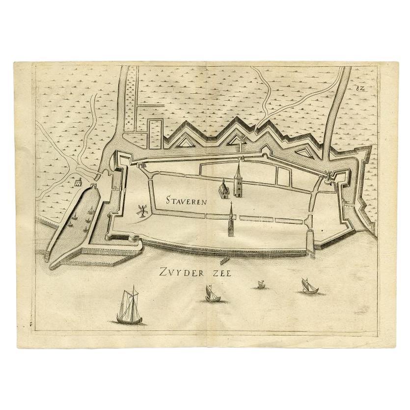
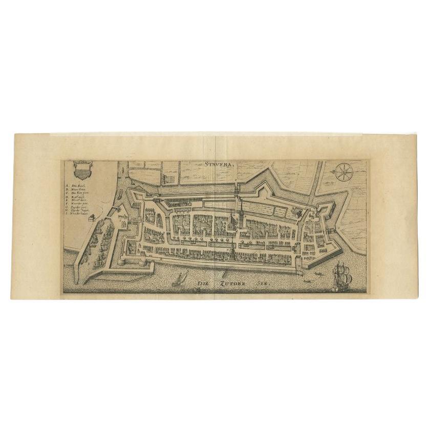
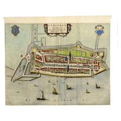
Antique Map of Stavoren by Priorato, 1673
About the Item
Antique map titled 'Staveren'. Original antique map of the city of Stavoren, Friesland, the Netherlands. This map orginates from 'Teatro del Belgio (..)', published in Frankfurt am Main in 1673 by Gualdo Priorato. Artists and Engravers: Author: Galeazzo Gualdo Priorato (1606-1678) entered military service at a very young age and served in Flanders under the Prince of Orange. After his retirement, he authored several historical accounts including the Teatro del Belgio, which described the Catholic/Protestant wars in Belgium and Netherlands during the seventeenth century. His superb plans do not show the internal layout of the cities, except for showing the locations of the major churches. Instead the emphasis is on the fortification, as well as on the surrounding site, rivers and canals.
Artist: Author: Galeazzo Gualdo Priorato (1606-1678) entered military service at a very young age and served in Flanders under the Prince of Orange. After his retirement, he authored several historical accounts including the Teatro del Belgio, which described the Catholic/Protestant wars in Belgium and Netherlands during the seventeenth century. His superb plans do not show the internal layout of the cities, except for showing the locations of the major churches. Instead the emphasis is on the fortification, as well as on the surrounding site, rivers and canals.
Condition: Very good. General age-related toning. Narrow margins. Please study image carefully.
Date: 1673
Overall size: 42.6 x 32.5 cm.
Image size: 0.001 x 41 x 32 cm.
Antique prints have long been appreciated for both their aesthetic and investment value. They were the product of engraved, etched or lithographed plates. These plates were handmade out of wood or metal, which required an incredible level of skill, patience and craftsmanship. Whether you have a house with Victorian furniture or more contemporary decor an old engraving can enhance your living space. We offer a wide range of authentic antique prints for any budget.
- Dimensions:Height: 12.8 in (32.5 cm)Width: 16.78 in (42.6 cm)Depth: 0 in (0.01 mm)
- Materials and Techniques:
- Period:
- Date of Manufacture:1673
- Condition:
- Seller Location:Langweer, NL
- Reference Number:
About the Seller
5.0
Platinum Seller
These expertly vetted sellers are 1stDibs' most experienced sellers and are rated highest by our customers.
Established in 2009
1stDibs seller since 2017
1,928 sales on 1stDibs
Typical response time: <1 hour
- ShippingRetrieving quote...Ships From: Langweer, Netherlands
- Return PolicyA return for this item may be initiated within 14 days of delivery.
More From This SellerView All
- Antique Map of Stavoren by Priorato, 1673Located in Langweer, NLAntique map titled 'Staveren'. Original antique map of the city of Stavoren, Friesland, the Netherlands. This map orginates from 'Teatro del Belgio (..)', published in Frankfurt am M...Category
Antique 17th Century Maps
MaterialsPaper
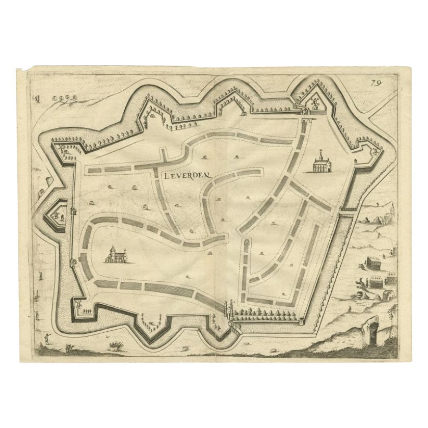
- Antique Map of the City of Leeuwarden by Priorato, 1673Located in Langweer, NLAntique map titled 'Leverden'. This map depicts the city of Leeuwarden (Friesland, The Netherlands). This original antique print originates from 'Teatro del Belgio (…)', published in...Category
Antique 17th Century Maps
MaterialsPaper
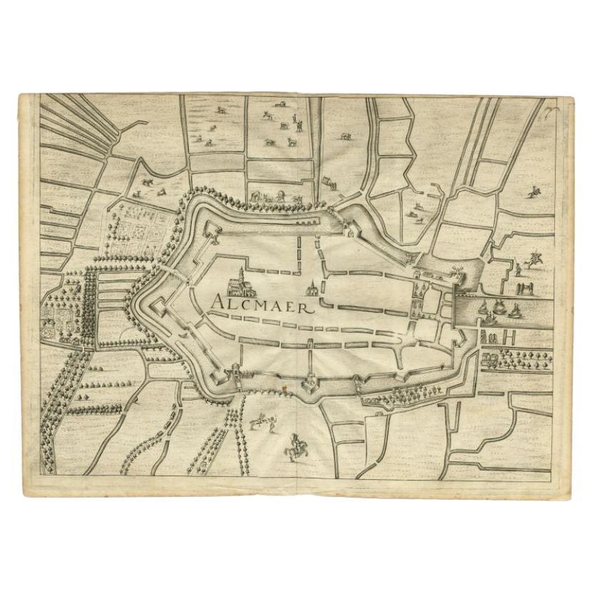
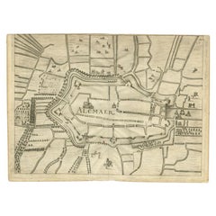
- Antique Map of the City of Alkmaar by Priorato, 1673Located in Langweer, NLAntique map titled 'Alcmaer'. Original map of the city of Alkmaar, the Netherlands. This map originates from 'Teatro del Belgio', by G. Gualdo Priorato. Artists and Engravers: Author...Category
Antique 17th Century Maps
MaterialsPaper
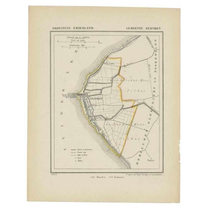
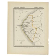
- Antique Map of Stavoren by Kuyper, 1868Located in Langweer, NLAntique map titled 'Provincie Friesland - Gemeente Stavoren'. Map of the township of Stavoren, Friesland. This map originates from 'Gemeente-Atlas van Nederland' by J. Kuyper. Artist...Category
Antique 19th Century Maps
MaterialsPaper
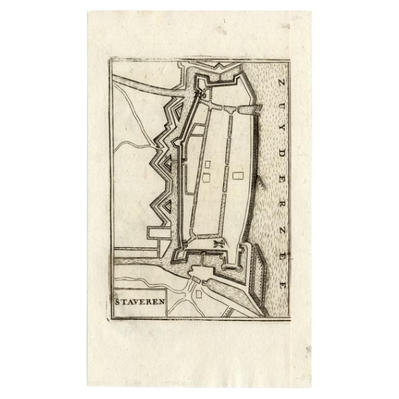
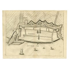
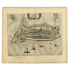
- Antique Map of Stavoren by Blaeu, 1649Located in Langweer, NLAntique map titled 'Staveren'. Original antique map of the city of Stavoren, Friesland, The Netherlands. This map originates from 'Toonneel der Steden van de Vereenighde Nederlanden'...Category
Antique 17th Century Maps
MaterialsPaper
- Antique Map of Stavoren by Blaeu, 1649Located in Langweer, NLAntique map titled 'Staveren'. Original antique map of the city of Stavoren, Friesland, The Netherlands. This map originates from 'Toonneel der Steden van de Vereenighde Nederlanden'...Category
Antique 17th Century Maps
MaterialsPaper
You May Also Like
- 1861 Topographical Map of the District of Columbia, by Boschke, Antique MapLocated in Colorado Springs, COPresented is an original map of Albert Boschke's extremely sought-after "Topographical Map of the District of Columbia Surveyed in the Years 1856 ...Category
Antique 1860s American Historical Memorabilia
MaterialsPaper
- 1907 Map of Colorado, Antique Topographical Map, by Louis NellLocated in Colorado Springs, COThis highly detailed pocket map is a topographical map of the state of Colorado by Louis Nell from 1907. The map "has been complied from all availabl...Category
Antique Early 1900s American Maps
MaterialsPaper
- Antique Map of Italy by Andriveau-Goujon, 1843By Andriveau-GoujonLocated in New York, NYAntique Map of Italy by Andriveau-Goujon, 1843. Map of Italy in two parts by Andriveau-Goujon for the Library of Prince Carini at Palazzo Carini i...Category
Antique 1840s French Maps
MaterialsLinen, Paper
- Antique Map of Principality of MonacoBy Antonio Vallardi EditoreLocated in Alessandria, PiemonteST/619 - "Old Geographical Atlas of Italy - Topographic map of ex-Principality of Monaco" - ediz Vallardi - Milano - A somewhat special edition ---Category
Antique Late 19th Century Italian Other Prints
MaterialsPaper
- Original Antique Map of Russia By Arrowsmith. 1820Located in St Annes, LancashireGreat map of Russia Drawn under the direction of Arrowsmith Copper-plate engraving Published by Longman, Hurst, Rees, Orme and Brown, 1820 Unframed.Category
Antique 1820s English Maps
MaterialsPaper
- 1864 Map of North America, Antique Hand-Colored Map, by Adolphe Hippolyte DufourLocated in Colorado Springs, COOffered is a map of North America entitled Amerique du Nord from 1864. This rare, separately published wall map was produced by Adolphe Hippolyte Dufour. This map includes vibrant an...Category
Antique 1860s French Maps
MaterialsPaper


Recently Viewed
View AllMore Ways To Browse
On Site Antiques
Antique Prince And
Antique Church Collectibles
Used Catholic Church Furniture
Catholic Church Furniture
Antique Catholic Church Furniture
Lithograph City Maps
Military Map
Military Maps
City Map Lithograph
Antique War Map
Military Engraving
Map Of Belgium
Antique Catholic Prints
Belgium Antique Map
Frankfurt Map
Antique 16th Century Plates
Antique Caribbean Furniture