Items Similar to Antique Map of The United States of North America, 1882


Want more images or videos?
Request additional images or videos from the seller
1 of 7
Antique Map of The United States of North America, 1882
$236.29
$295.3620% Off
£177.11
£221.3920% Off
€200
€25020% Off
CA$324.62
CA$405.7820% Off
A$362.41
A$453.0120% Off
CHF 189.90
CHF 237.3720% Off
MX$4,436.27
MX$5,545.3320% Off
NOK 2,411.71
NOK 3,014.6320% Off
SEK 2,273.93
SEK 2,842.4220% Off
DKK 1,522.47
DKK 1,903.0920% Off
About the Item
This is a historical map titled "The United States of North America, Central Part" from the 1882 Blackie Atlas. It depicts the continental United States with a high level of detail, including state boundaries, cities, rivers, and the topography indicated by hachure marks.
The map shows a network of railways crisscrossing the country, reflecting the importance of rail travel and transport during the late 19th century. The map also includes the Gulf of Mexico and parts of adjacent countries such as Canada and Mexico, with less detail, highlighting the focus on the U.S.
Significant geographical features, like the Mississippi River system, the Rocky Mountains, and the Great Plains are well-represented, showing the varied landscapes across the country. The Great Lakes are also prominently featured in the upper right portion of the map.
The detail of the map, including city names and topographical features, suggests it was a comprehensive educational or navigational tool for its time. The map's scale and grid of latitude and longitude lines would have been essential for planning travel or understanding the country's geography.
The map shows the United States as it would have appeared in 1882. This was a significant period in American history, occurring in the latter part of what is known as the Gilded Age, a time marked by rapid economic growth, especially in the North and West, following the Civil War.
Here are some key aspects of the United States during the 1882 timeframe:
1. **Industrialization**: The US was undergoing rapid industrialization, with advances in technology and an expanding railroad network which contributed to the growth of industries like steel and manufacturing.
2. **Railroads**: The completion of the Transcontinental Railroad in 1869 dramatically changed the nation, making travel and the transportation of goods across the continent much quicker and easier. By 1882, additional rail lines had been constructed, further expanding the network.
3. **Immigration**: There was a significant increase in immigration during this period, with many people coming from Europe to the United States. The immigrants provided a labor force for the growing industries and also settled in the expanding territories out West.
4. **Urbanization**: With the growth of industry came the growth of cities as centers of commerce and work. There was a significant movement of the population from rural areas to urban centers.
5. **Westward Expansion**: The American frontier was still open, and many people moved westward in search of land, opportunity, and gold. The Homestead Act of 1862 had accelerated this movement by allowing people to claim land for farming.
6. **Native American Displacement**: This period was also marked by conflict and displacement of Native American tribes. As settlers moved west, they encroached on Native American lands, leading to battles and ultimately the forced relocation of many tribes.
7. **Reconstruction Era**: The country was still dealing with the aftermath of the Civil War, particularly in the Southern states. The Reconstruction era was coming to an end, with federal troops withdrawing from the South and the beginning of the Jim Crow era of racial segregation laws.
8. **Economic Disparity**: Although this period was marked by prosperity for many, it also saw the beginning of significant economic disparity and the rise of the so-called "Robber Barons," wealthy industrialists and financiers who amassed great wealth.
The map itself would show the states and territories of the time, with many of the western regions not yet achieving statehood. The intricate detailing of the railway lines would be a testament to their importance and prevalence. The geographical features, such as the Mississippi River and the Rocky Mountains, would be key natural landmarks shaping the economic and social development of the nation.
- Dimensions:Height: 14.97 in (38 cm)Width: 22.45 in (57 cm)Depth: 0 in (0.02 mm)
- Materials and Techniques:
- Period:
- Date of Manufacture:1882
- Condition:Good condition, folding line in the middle. The outer borders are slightly discolored due to age, but not the image. Study the image carefully.
- Seller Location:Langweer, NL
- Reference Number:Seller: BG-13601-2-611stDibs: LU3054338776232
About the Seller
5.0
Recognized Seller
These prestigious sellers are industry leaders and represent the highest echelon for item quality and design.
Platinum Seller
Premium sellers with a 4.7+ rating and 24-hour response times
Established in 2009
1stDibs seller since 2017
2,513 sales on 1stDibs
Typical response time: <1 hour
- ShippingRetrieving quote...Shipping from: Langweer, Netherlands
- Return Policy
Authenticity Guarantee
In the unlikely event there’s an issue with an item’s authenticity, contact us within 1 year for a full refund. DetailsMoney-Back Guarantee
If your item is not as described, is damaged in transit, or does not arrive, contact us within 7 days for a full refund. Details24-Hour Cancellation
You have a 24-hour grace period in which to reconsider your purchase, with no questions asked.Vetted Professional Sellers
Our world-class sellers must adhere to strict standards for service and quality, maintaining the integrity of our listings.Price-Match Guarantee
If you find that a seller listed the same item for a lower price elsewhere, we’ll match it.Trusted Global Delivery
Our best-in-class carrier network provides specialized shipping options worldwide, including custom delivery.More From This Seller
View AllAntique Map of the United States of North America, c.1882
Located in Langweer, NL
Antique map titled 'United States of North America'. Old map of the United States of North America. This map originates from 'The Royal Atlas of Modern Geography, Exhibiting, in a Se...
Category
Antique 1880s Maps
Materials
Paper

$330 Sale Price
20% Off
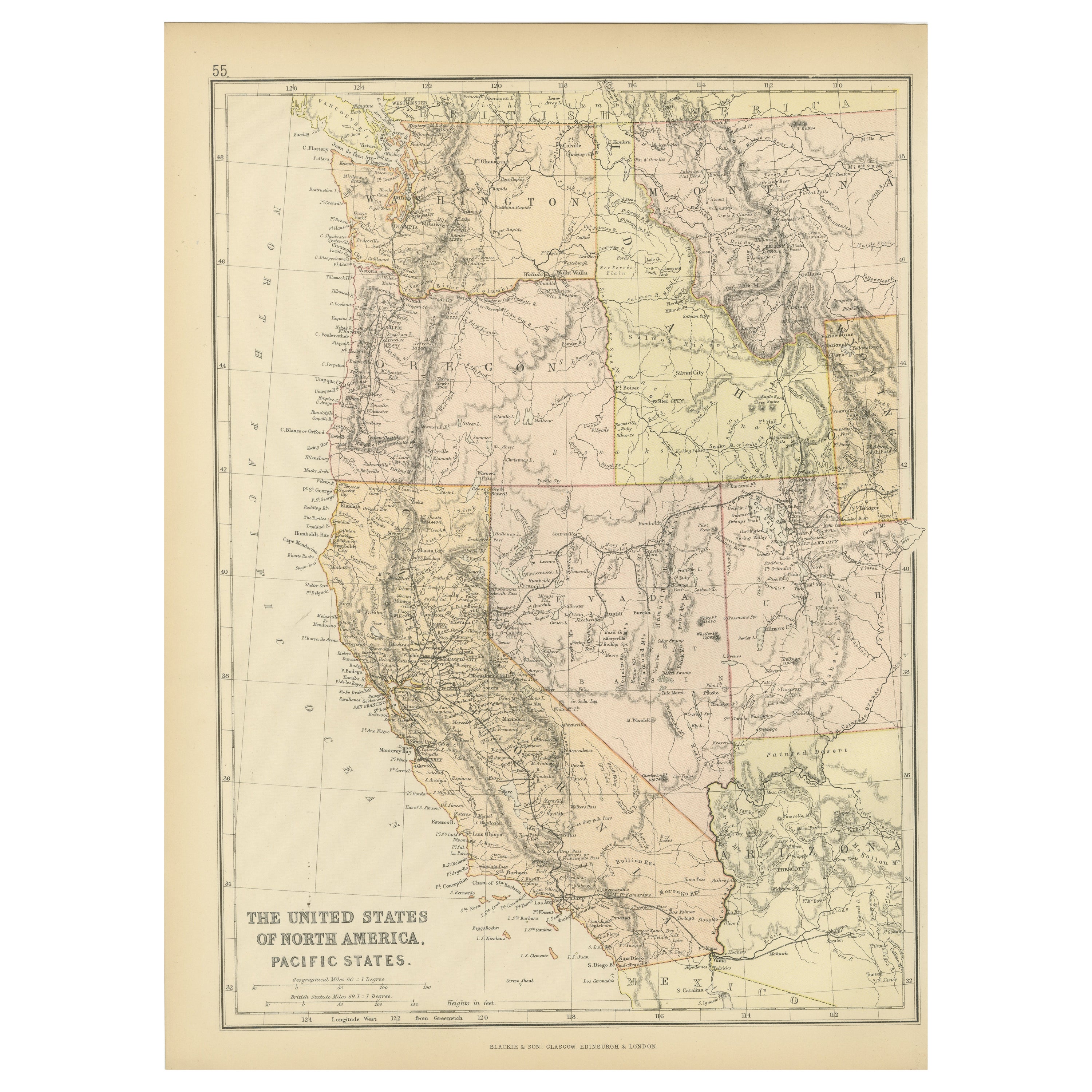
Antique Map of The United States of North America, Pacific States, 1882
Located in Langweer, NL
The map is from the same 1882 Blackie Atlas and focuses on the Pacific States of the United States of America during that period. Here are some details and historical context about t...
Category
Antique 1880s Maps
Materials
Paper

$236 Sale Price
20% Off
Free Shipping
Antique Map of North America by A & C. Black, 1870
Located in Langweer, NL
Antique map titled 'North America'. Original antique map of North America. This map originates from ‘Black's General Atlas of The World’. Published by A & C. Black, 1870.
Category
Antique Late 19th Century Maps
Materials
Paper

$259 Sale Price
20% Off
Antique Map of the United States by Titus '1871'
Located in Langweer, NL
Antique map titled 'The United States of America'. Original antique map of the United States. This map originates from 'Atlas of Prebl...
Category
Antique Late 19th Century Maps
Materials
Paper

$756 Sale Price
20% Off
Antique Map of the United States of America by Lapie '1842'
Located in Langweer, NL
Antique map titled 'Carte des États-Unis d'Amérique'. Map of the United States of America (USA). This map originates from 'Atlas universel...
Category
Antique Mid-19th Century Maps
Materials
Paper

$567 Sale Price
20% Off
Antique Map of North America by Johnson, '1872'
Located in Langweer, NL
Antique map titled 'Johnson's North America'. Original map of North America, with an inset map of the Hawaiian group or Sandwich Islands. This map originates from 'Johnson's New Illu...
Category
Antique Late 19th Century Maps
Materials
Paper

$378 Sale Price
20% Off
You May Also Like
Large Original Antique Map of the United States of America. 1891
By Rand McNally & Co.
Located in St Annes, Lancashire
Fabulous map of The United States
Original color
By Rand, McNally & Co.
Dated 1891
Unframed
Free shipping.
Category
Antique 1890s American Maps
Materials
Paper

Original Antique Map of The United States of America by Dower, circa 1835
Located in St Annes, Lancashire
Nice map of the USA
Drawn and engraved by J.Dower
Published by Orr & Smith. C.1835
Unframed.
Free shipping
Category
Antique 1830s English Maps
Materials
Paper

Original Antique Map of United States, Grattan and Gilbert, 1843
Located in St Annes, Lancashire
Great map of United States
Drawn and engraved by Archer
Published by Grattan and Gilbert. 1843
Original colour
Unframed.
Category
Antique 1840s English Maps
Materials
Paper

Large Original Vintage Map of North America, circa 1920
Located in St Annes, Lancashire
Great map of North America
Original color. Good condition
Published by Alexander Gross
Unframed.
Category
Vintage 1920s English Edwardian Maps
Materials
Paper

North America. Century Atlas antique vintage map
Located in Melbourne, Victoria
'The Century Atlas. North America'
Original antique map, 1903.
Central fold as issued. Map name and number printed on the reverse corners.
Sheet 40cm by 29.5cm.
Category
Early 20th Century Victorian More Prints
Materials
Lithograph

1864 Map of North America, Antique Hand-Colored Map, by Adolphe Hippolyte Dufour
Located in Colorado Springs, CO
Offered is a map of North America entitled Amerique du Nord from 1864. This rare, separately published wall map was produced by Adolphe Hippolyte Dufour. This map includes vibrant an...
Category
Antique 1860s French Maps
Materials
Paper

More Ways To Browse
Railway Map
Antique Crow
Gilded Age Antiques
U S Furniture Industries
Antique Level Tool
20th Century Spanish Table
Antonio Bellini
Antique Oushak Carpets
Blue Coffee Tables
German Bauhaus Posters
1945 Chair Juhl
Antique Three Leg Table
Folke Arstrom
Silver Over Copper
Vintage Barware Glasses
Antique Etched Glass
Antique French Shell
Coffee Table Black Italian Modern