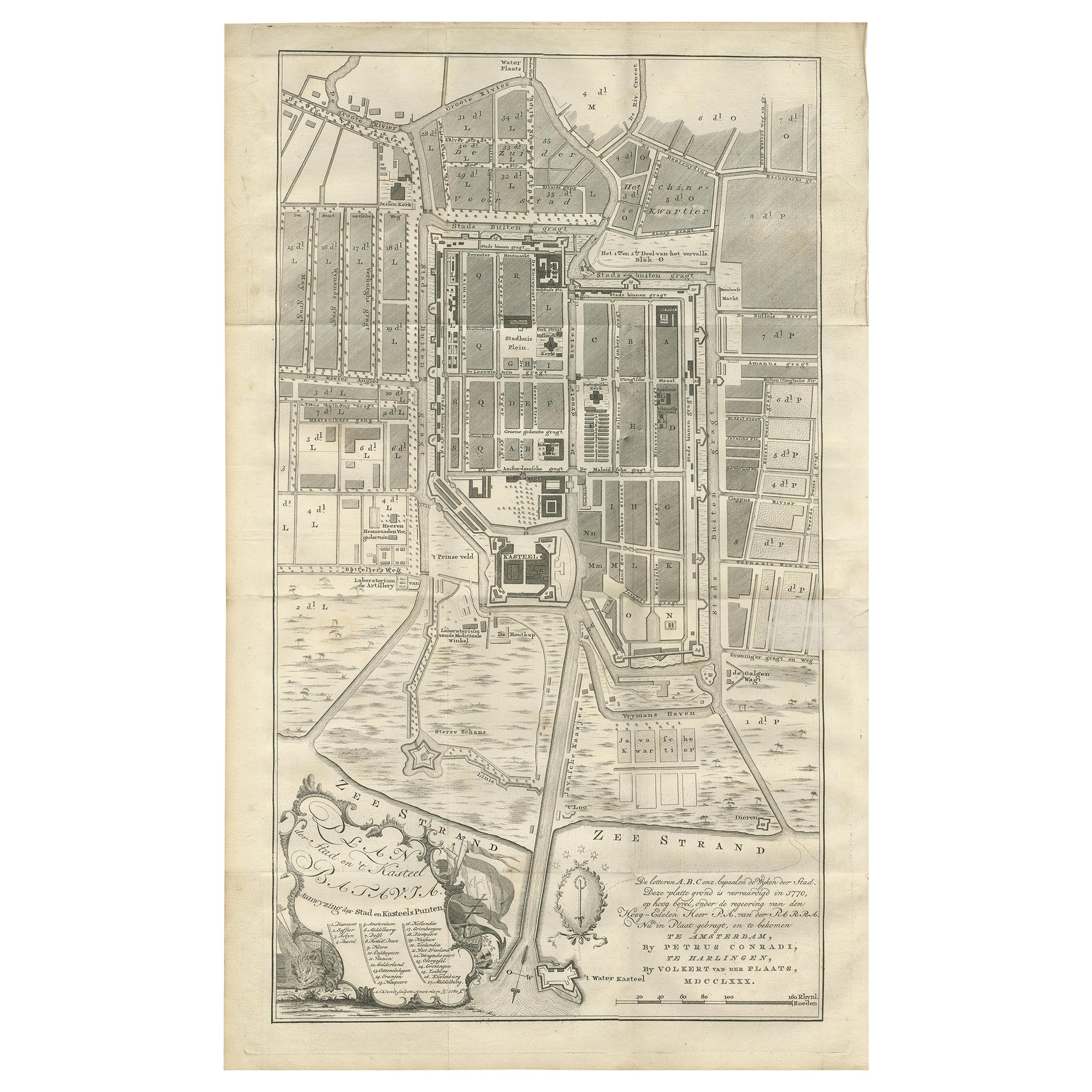
Items Similar to Antique Plan of Batavia, Nowadays Jakarta, Indonesia, 1780


Want more images or videos?
Request additional images or videos from the seller
1 of 6
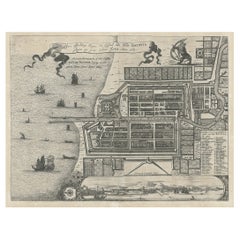
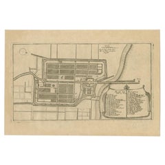
Antique Plan of Batavia, Nowadays Jakarta, Indonesia, 1780
$1,772.87
$2,216.0820% Off
£1,318.83
£1,648.5420% Off
€1,478.40
€1,84820% Off
CA$2,427.66
CA$3,034.5820% Off
A$2,699.23
A$3,374.0320% Off
CHF 1,409.39
CHF 1,761.7320% Off
MX$32,856.17
MX$41,070.2220% Off
NOK 17,983.17
NOK 22,478.9720% Off
SEK 16,849.37
SEK 21,061.7220% Off
DKK 11,254.24
DKK 14,067.8020% Off
Shipping
Retrieving quote...The 1stDibs Promise:
Authenticity Guarantee,
Money-Back Guarantee,
24-Hour Cancellation
About the Item
Antique map titled 'Plan der Stad en 't Kasteel Batavia'. A very rare late 18th century detailed plan of Batavia with an alpha-numeric key showing the main areas and buildings (only the numeric key is shown in the plan legend). The plan was engraved by A. van Krevelt of Amsterdam in 1780 and published by Peter Conradi in c. 1780.
Artists and Engravers: Abram van Krevelt (1732-1784) was a Dutch engraver of maps and characters, active in Amsterdam.
Condition: Very good, some professional repairs and restoration. Please study image carefully.
Date: 1780
Overall size: 47 x 73 cm.
Image size: 36 x 63 cm.
We sell original antique maps to collectors, historians, educators and interior decorators all over the world. Our collection includes a wide range of authentic antique maps from the 16th to the 20th centuries. Buying and collecting antique maps is a tradition that goes back hundreds of years. Antique maps have proved a richly rewarding investment over the past decade, thanks to a growing appreciation of their unique historical appeal. Today the decorative qualities of antique maps are widely recognized by interior designers who appreciate their beauty and design flexibility. Depending on the individual map, presentation, and context, a rare or antique map can be modern, traditional, abstract, figurative, serious or whimsical. We offer a wide range of authentic antique maps for any budget.
- Dimensions:Height: 28.75 in (73 cm)Width: 18.51 in (47 cm)Depth: 0 in (0.01 mm)
- Materials and Techniques:
- Period:
- Date of Manufacture:1780
- Condition:Repaired: Condition: Very good, some professional repairs and restoration. Please study image carefully. Condition: Very good, some professional repairs and restoration. Please study image carefully.
- Seller Location:Langweer, NL
- Reference Number:Seller: BG-05353'1stDibs: LU3054329261552
About the Seller
5.0
Recognized Seller
These prestigious sellers are industry leaders and represent the highest echelon for item quality and design.
Platinum Seller
Premium sellers with a 4.7+ rating and 24-hour response times
Established in 2009
1stDibs seller since 2017
2,511 sales on 1stDibs
Typical response time: <1 hour
- ShippingRetrieving quote...Shipping from: Langweer, Netherlands
- Return Policy
Authenticity Guarantee
In the unlikely event there’s an issue with an item’s authenticity, contact us within 1 year for a full refund. DetailsMoney-Back Guarantee
If your item is not as described, is damaged in transit, or does not arrive, contact us within 7 days for a full refund. Details24-Hour Cancellation
You have a 24-hour grace period in which to reconsider your purchase, with no questions asked.Vetted Professional Sellers
Our world-class sellers must adhere to strict standards for service and quality, maintaining the integrity of our listings.Price-Match Guarantee
If you find that a seller listed the same item for a lower price elsewhere, we’ll match it.Trusted Global Delivery
Our best-in-class carrier network provides specialized shipping options worldwide, including custom delivery.More From This Seller
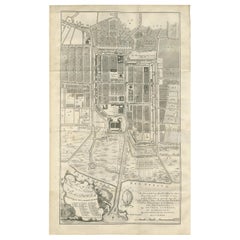
View AllAntique Map of Batavia 'Jakarta, Indonesia', the Dutch East-Indies, 1782
Located in Langweer, NL
Antique map titled 'Batavia zo als het was in den Jaare 1731.' (Batavia as it was in the year 1731.) Map of the city of Batavia (Jakarta) in Indonesia. With legend and scale. This pr...
Category
Antique 18th Century Maps
Materials
Paper

$613 Sale Price
20% Off
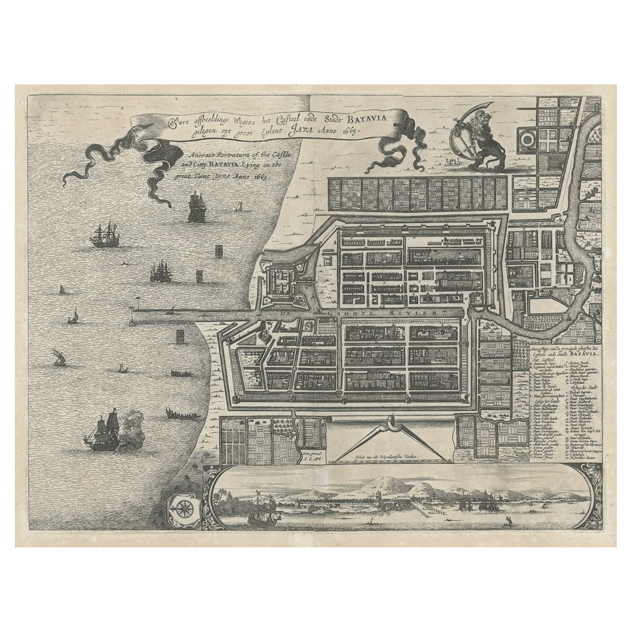
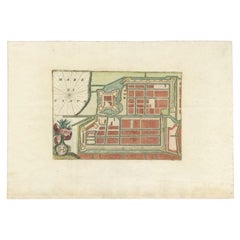
Antique Plan of the Castle & City of Batavia 'Jakarta' on Java, Indonesia, c1669
Located in Langweer, NL
Antique map Batavia titled 'Ware Affbeeldinge wegens het Casteel ende Stadt Batavia'.
Antique print of the castle and city of Batavia on the Island of Java'. Rare edition with En...
Category
Antique 1660s Maps
Materials
Paper
$1,199 Sale Price
20% Off
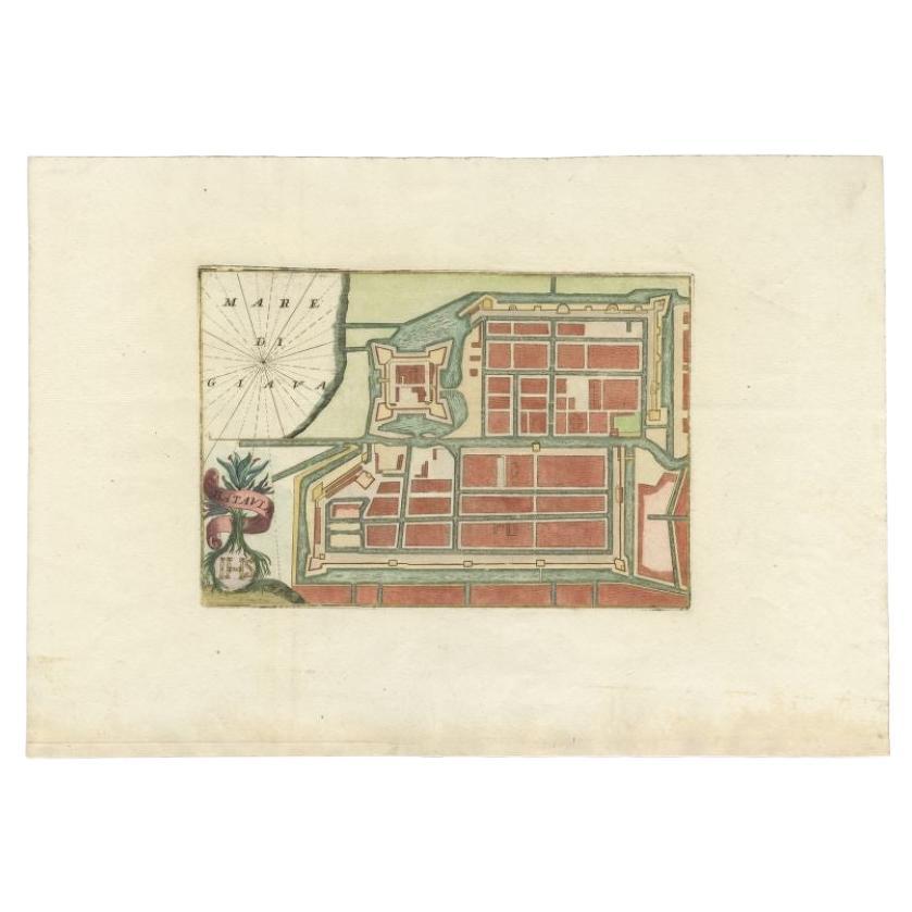
Antique Plan of Batavia in the Dutch East Indies or Nowadays Jakarta, Indonesia
Located in Langweer, NL
Rare plan of Batavia titled 'Batavia'. With 'IHS' monogram, symbolizing Jesus Christ. Source unknown, to be determined.
Artists and Enrgavers: Anonymous.
Condition: Very good,...
Category
Antique 18th Century Maps
Materials
Paper
$853 Sale Price
20% Off
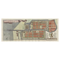
Antique Plan of Batavia by Van Krevelt, 'circa 1780'
Located in Langweer, NL
Antique map titled 'Plan der Stad en 't Kasteel Batavia'. A very rare late 18th century detailed plan of Batavia, Indonesia, with an alpha-numeric key showing the main areas and buil...
Category
Antique Late 18th Century Prints
Materials
Paper
$1,798 Sale Price
40% Off
Antique Map of Batavia, Nowadays Jakarta, the Capital of Indonesia, 1782
Located in Langweer, NL
Antique map Batavia titled 'Batavia zo als het was in den Jaare 1731'. Old map of the city of Batavia (Jakarta) in Indonesia. Originates from 'Batavia, de Hoofdstad van Neerlands O. ...
Category
Antique 18th Century Maps
Materials
Paper
$911 Sale Price
20% Off
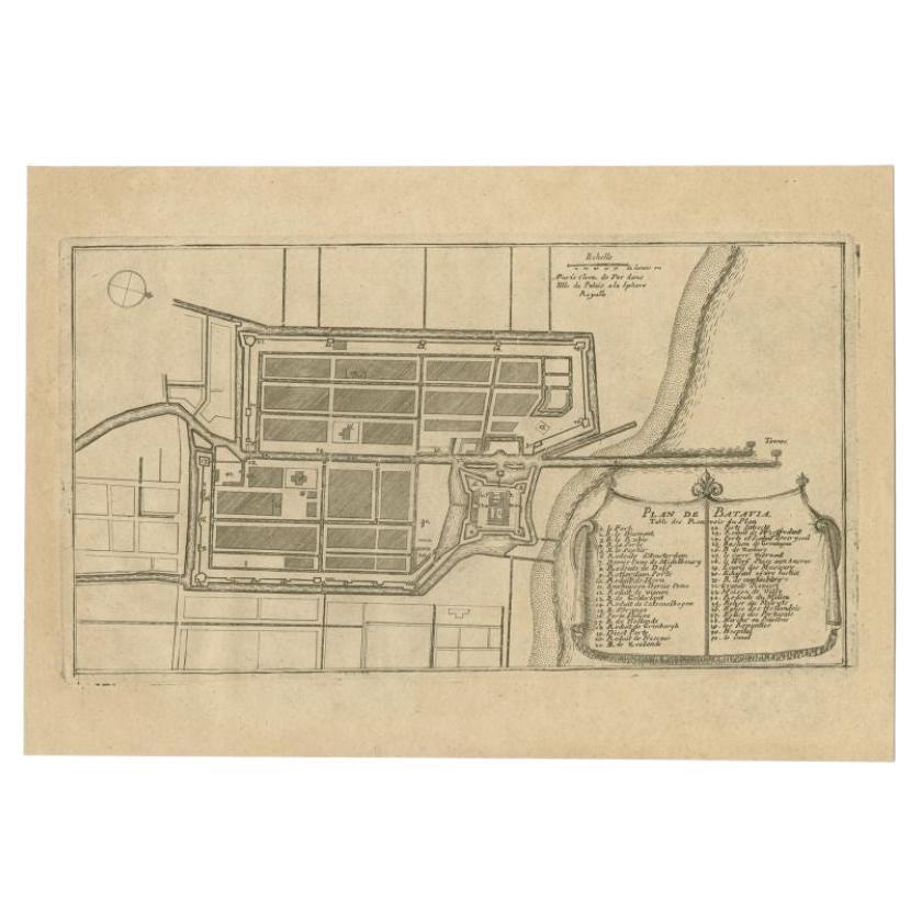
Antique Plan of Batavia in the Dutch East Indies or Indonesia, circa 1695
Located in Langweer, NL
Antique print titled 'Plan de Batavia'. Plan of Batavia, Jakarta, Indonesia. Oriented with north to the lower right by a simple compass rose. French title and key cartouche in drape form.
Artists and Engravers: Nicolas de Fer...
Category
Antique 17th Century Maps
Materials
Paper
$278 Sale Price
20% Off
You May Also Like
Original Antique Map or City Plan of Madrid, Spain. Circa 1835
Located in St Annes, Lancashire
Nice map of Madrid
Drawn and engraved by J.Dower
Published by Orr & Smith. C.1835
Unframed.
Free shipping
Category
Antique 1830s English Maps
Materials
Paper

Large Original Antique Folding Map of Manchester, England, Dated 1793
Located in St Annes, Lancashire
Superb map of Manchester and Salford
Folding map. Printed on paper laid on to the original canvas
Unframed.
Published by C. Laurent, 1793.
Free shippi...
Category
Antique 1790s English Georgian Maps
Materials
Canvas, Paper

Original Antique Map or City Plan of Geneva, Switzerland. Circa 1835
Located in St Annes, Lancashire
Nice map of Geneva
Drawn and engraved by J.Dower
Published by Orr & Smith. C.1835
Unframed.
Free shipping
Category
Antique 1830s English Maps
Materials
Paper

Original Antique Map or City Plan of Rome, Italy. Circa 1835
Located in St Annes, Lancashire
Nice map of Rome
Drawn and engraved by J.Dower
Published by Orr & Smith. C.1835
Unframed.
Free shipping
Category
Antique 1830s English Maps
Materials
Paper

Original Antique Map or City Plan of Amsterdam, Netherlands. Circa 1835
Located in St Annes, Lancashire
Nice map of Amsterdam
Drawn and engraved by J.Dower
Published by Orr & Smith. C.1835
Unframed.
Free shipping
Category
Antique 1830s English Maps
Materials
Paper

Original Large Antique Map of Paris, France by John Dower, 1861
Located in St Annes, Lancashire
Fabulous monochrome map of Paris.
Vignettes of St Germain En Laye, Saint Cloud, Versailles and Fontainbleau.
Unframed.
Drawn by J.Dower.
Lithography by Weller. 4 sheets joined to...
Category
Antique 1860s English Victorian Maps
Materials
Paper

More Ways To Browse
Indonesian Antiques
Indonesia Jakarta
Antique Map Of Yorkshire
Antique Map Vietnam
Antique Maps Massachusetts
Guyana Antique Map
Peninsular War
Santa Cruz Island
Ukraine Antique Map
Antique Life Buoy
Antique Map Nova Scotia
Antique Map Of Argentina
Antique Maps Of Kansas
Cambodia Antique Map
Magellan Map
Map Ukraine
Mariners Chart
Papua New Guinea Antique Map