Items Similar to Bird’s-Eye View Map of Gallipoli: Fortified Ionian Gem by Mattheus Merian, 1688
Want more images or videos?
Request additional images or videos from the seller
1 of 10
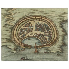
Bird’s-Eye View Map of Gallipoli: Fortified Ionian Gem by Mattheus Merian, 1688
$443.54
£329.49
€370
CA$615.90
A$672.09
CHF 352.52
MX$8,162.79
NOK 4,403.22
SEK 4,161.26
DKK 2,816.77
About the Item
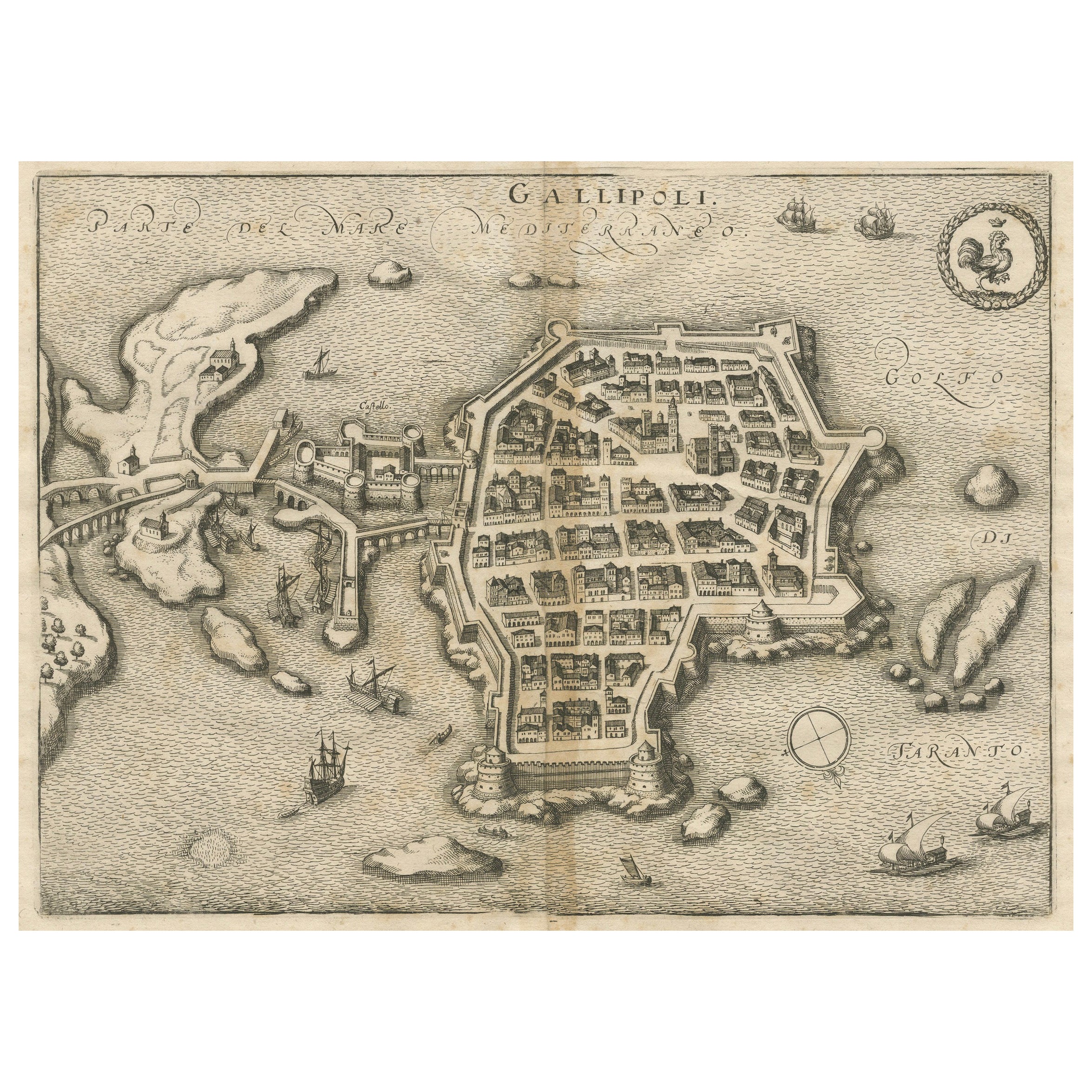
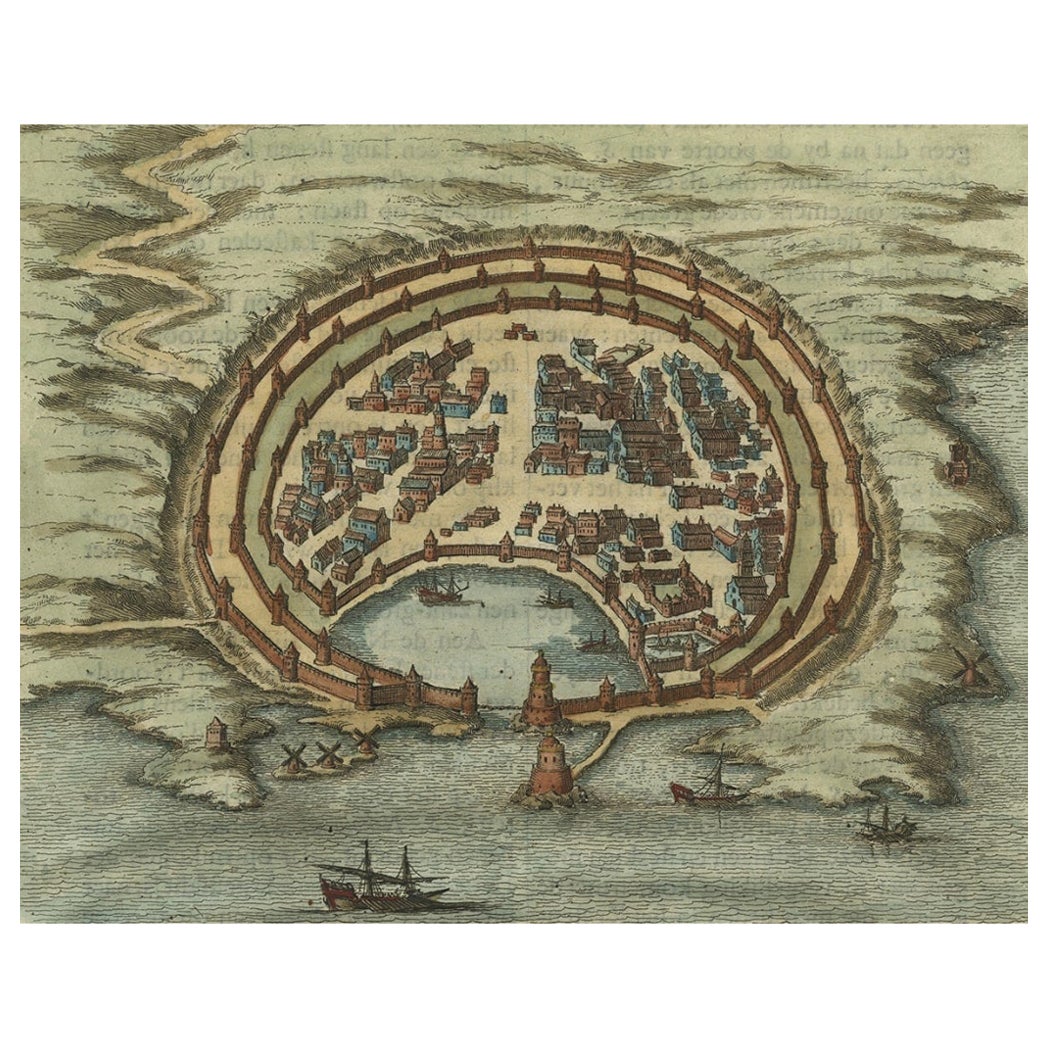
Bird’s-Eye View Map of Gallipoli: Fortified Ionian Gem by Mattheus Merian
Description:
This exquisitely detailed map of Gallipoli, crafted by the renowned engraver Mattheus Merian, offers a unique bird’s-eye perspective of the fortified town as it stood in the early 17th century. Situated on a rocky island in the Ionian Sea, Gallipoli is depicted with remarkable accuracy, highlighting its strategic importance and architectural intricacies. The map is oriented unconventionally with north in the lower right corner, inviting viewers to explore the town’s layout from a distinct vantage point. Prominent features include the robust city walls, intricate street patterns, and the bustling harbor, animated with tiny, detailed ships that underscore the town’s vibrant maritime activities.
The upper right corner of the map is adorned with Gallipoli’s city arms, emphasizing local pride and heritage. Each building, pathway, and fortification is rendered with meticulous care, reflecting Merian’s dedication to combining artistic beauty with geographical precision.
About the Maker:
Mattheus Merian the Elder (1593-1650) was a notable Swiss-German engraver and publisher. Born in Basel, Switzerland, he later moved to Frankfurt, where he established his publishing house. Merian is renowned for his detailed town plans and bird’s-eye views, which were among the most sought after in the 17th century for their accuracy and aesthetic appeal. His works serve not only as historical documents but as masterpieces of engraving and design, providing a unique window into the urban and cultural landscapes of the time.
Today, Gallipoli, located in the Apulia region of southern Italy, is a picturesque town that beautifully blends historical charm with modern amenities. Divided into two main sections, the town features an old city on a limestone island and a more modern mainland area, connected by a 17th-century bridge. The old town is renowned for its fortified historical center, surrounded by impressive beaches and a vibrant street scene, making it a popular tourist destination.
The historical significance of Gallipoli is reflected in its architecture and urban layout, which bear traces of Greek, Roman, Byzantine, and Norman influences over the millennia. The city's most iconic structures include the Angevin-Aragonese Castle and the Baroque Cathedral of Sant'Agata. Gallipoli's strategic coastal location made it a vital maritime hub throughout history, a role that continues to influence its culture and economy today.
Gallipoli's role in wartime history, particularly during the Ottoman period when it served as a fortress, has left a lasting mark on its cultural and architectural heritage. Despite these turbulent times, the town has managed to preserve its unique southern Italian charm, characterized by colorful fishing boats, stone churches, and ancient city walls that offer a glimpse into its storied past.
The town nowadays offers a mix of attractions from relaxing on Baia Verde beach, exploring historical sites like the Castello di Gallipoli, to enjoying local cuisines and crafts in the historic center. The blend of its rich history, stunning natural beauty, and contemporary cultural offerings makes Gallipoli a compelling destination for travelers.
- Dimensions:Height: 9.26 in (23.5 cm)Width: 12.01 in (30.5 cm)Depth: 0 in (0.02 mm)
- Materials and Techniques:Paper,Engraved
- Place of Origin:
- Period:1680-1689
- Date of Manufacture:1688
- Condition:Condition: good given age. Paper lightly browned with one spot in center. General age-related toning and/or occasional minor defects from handling. One small tear in right bottom has been repaired. Please study scan carefully.
- Seller Location:Langweer, NL
- Reference Number:Seller: BG-13827-21stDibs: LU3054341112322
About the Seller
5.0
Recognized Seller
These prestigious sellers are industry leaders and represent the highest echelon for item quality and design.
Platinum Seller
Premium sellers with a 4.7+ rating and 24-hour response times
Established in 2009
1stDibs seller since 2017
2,641 sales on 1stDibs
Typical response time: <1 hour
- ShippingRetrieving quote...Shipping from: Langweer, Netherlands
- Return Policy
Authenticity Guarantee
In the unlikely event there’s an issue with an item’s authenticity, contact us within 1 year for a full refund. DetailsMoney-Back Guarantee
If your item is not as described, is damaged in transit, or does not arrive, contact us within 7 days for a full refund. Details24-Hour Cancellation
You have a 24-hour grace period in which to reconsider your purchase, with no questions asked.Vetted Professional Sellers
Our world-class sellers must adhere to strict standards for service and quality, maintaining the integrity of our listings.Price-Match Guarantee
If you find that a seller listed the same item for a lower price elsewhere, we’ll match it.Trusted Global Delivery
Our best-in-class carrier network provides specialized shipping options worldwide, including custom delivery.More From This Seller
View AllGallipoli Fortifications: A 1688 Engraved Bird’s-Eye Map by Mattheus Merian
Located in Langweer, NL
Gallipoli Fortifications: A 1688 Bird’s-Eye Map by Mattheus Merian
Description: This exquisitely detailed map of Gallipoli, crafted by the renowned engraver Mattheus Merian, offers ...
Category
Antique 1680s German Maps
Materials
Paper
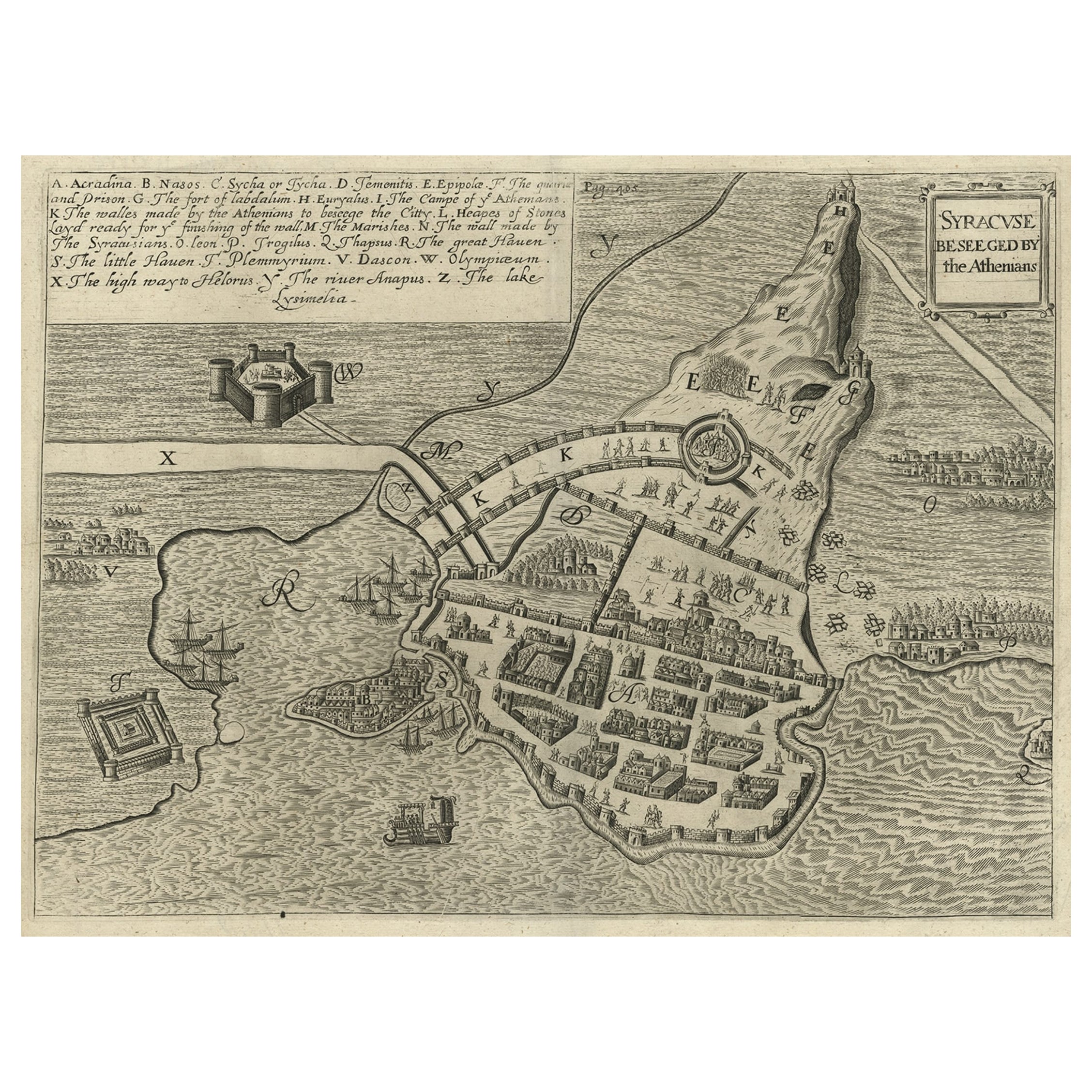
Antique Map of the Siege of Syracuse by the Athenians, 1648 – Thucydides
Located in Langweer, NL
Antique Map of the Siege of Syracuse by the Athenians, 1648 – Thucydides
This finely engraved plan depicts the Siege of Syracuse, one of the most dramatic episodes of the Peloponnes...
Category
Antique Mid-17th Century English Maps
Materials
Paper
$709 Sale Price
20% Off
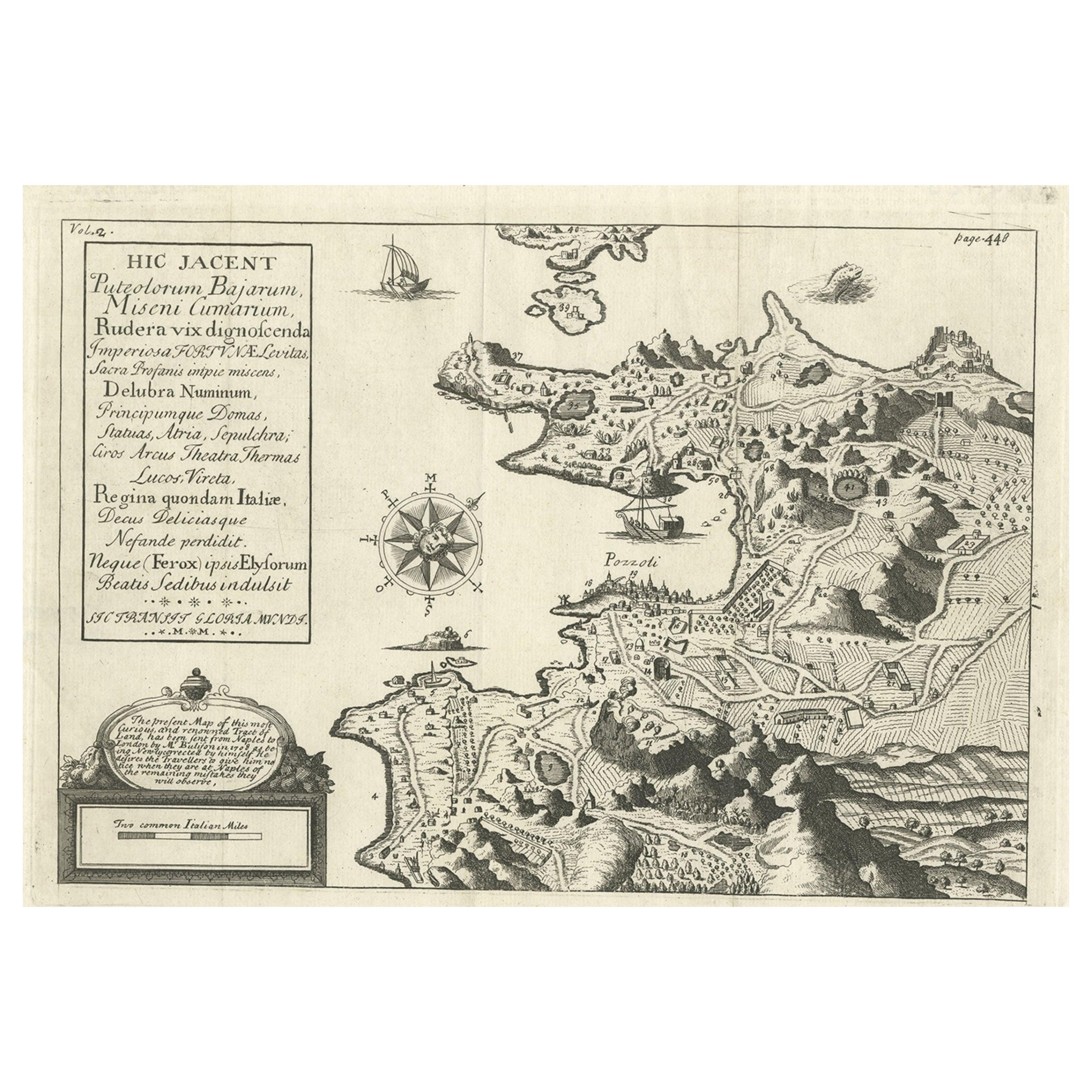
Old Original Map of Pozzuoli Near Naples in the Campania Region, Italy, ca.1740
Located in Langweer, NL
Antique map titled 'Hic Jacent Puteolorum Bajarum (..)'. Old map of the region of Pozzuoli showing the topographic and architectural features of interest. Pozzuoli is a city and comu...
Category
Antique 1740s Maps
Materials
Paper

$335 Sale Price
20% Off
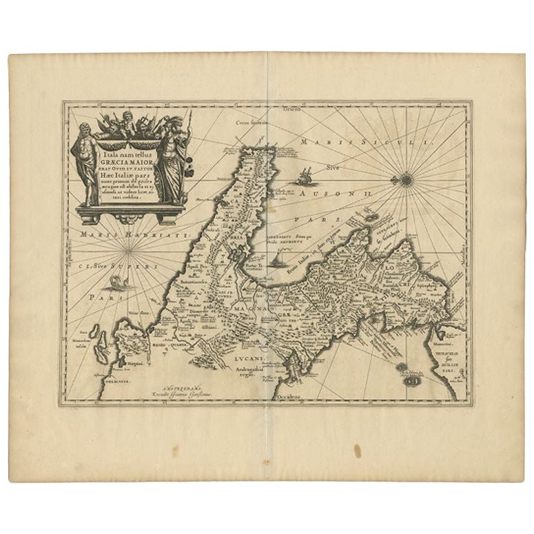
Antique Map of Southern Italy by Janssonius, C.1650
Located in Langweer, NL
"Antique map titled 'Itala nam tellus Graecia Maior erat Ovid. IV. Fastor. Haec Italiae pars nunc primum de prica aerugine est abstersa (..)'. Beautiful map of Southern Italy...
Category
Antique 17th Century Maps
Materials
Paper

$709 Sale Price
20% Off
Antique Engraving with a Plan of Rhodes, Greece, 1688
Located in Langweer, NL
Description: Antique map, titled: 'Rhodos.' - Plan of Rhodes, Greece. This map originates from 'Nauwkeurige Beschrijving der eilanden in de in de Archipel der Middellantsche Zee', by...
Category
Antique 1680s Maps
Materials
Paper
$431 Sale Price
20% Off
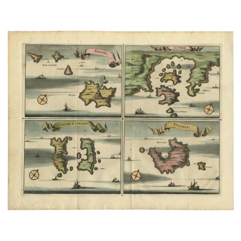
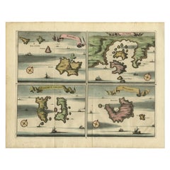
Antique Map of Nisari, Le Simie, Carchi Elimoia and Piscopia, Greece, 1687
Located in Langweer, NL
Antique map titled 'Carchi Elimoia, Nisari, Le Simie, Piscopia.' Sheet with four maps on one page showing Nisyros, Simi and other islands, Greece. Source unknown, to be determined. A...
Category
Antique 17th Century Maps
Materials
Paper
$402 Sale Price
20% Off
You May Also Like
18th Century Map Engraving - Plan of the Works of the City of Messina, Sicily
Located in Corsham, GB
A map of Messina, a harbour city in northeast Sicily. Inscribed with the title in plate to the lower edge, 'Plan of the Works of the City of Messina, one of the strongest and most co...
Category
18th Century More Prints
Materials
Engraving

$285 Sale Price
20% Off
Corfu, Big Antique Map from "Civitates Orbis Terrarum" - 1572-1617
By Franz Hogenberg
Located in Roma, IT
Braun G. and Hogenberg F., Corfu, from the collection Civitates Orbis Terrarum, Cologne, T. Graminaeus, 1572-1617. Image dimensions: cm 19 x 48; dimensions: cm 40 x 70.
Very lovely ...
Category
16th Century Landscape Prints
Materials
Etching
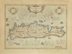
Map of Crete - Etching by Johannes Blaeu - 1650s
Located in Roma, IT
Map of Crete (Candia olim Creta) is an etching realized by Johannes BLAEU (1596-1673) in 1650s.
Etching hand watercolored.
The renowned map of the island of Crete by Blaeu, hand-...
Category
1650s Modern Figurative Prints
Materials
Etching
1597 German Map of Alexandria by Georg Braun and Frans Hogenberg
By Georg Braun and Frans Hogenberg
Located in Chapel Hill, NC
1597 Map of Alexandria by Georg Braun and Frans Hogenberg, Germany. From "Civitas Orbis Terrarum", part 2, published in Cologne by Bertram Buchholz. Printed in 2 parts. Title: "Alexa...
Category
Antique 16th Century German Renaissance Maps
Materials
Paper

1646 Jansson Map Entitled "Procinvia Connactiae, " Ric.a006
Located in Norton, MA
1646 Jansson map entitled
"Procinvia connactiae,"
Ric.a006
Description: The PROVINCE of CONNAVGT 490 x 380From vol 4 of Jansson's Atlas Novus 1646, published in Amsterdam with...
Category
Antique 17th Century Unknown Maps
Materials
Paper

Cadiz Island: A Framed 17th Century Hand-colored Map from Blaeu's Atlas Major
By Joan (Johannes) Blaeu
Located in Alamo, CA
This is a 17th century hand-colored map entitled "Insula Gaditana Isla de Cadiz" from Johannes (Joan) Blaeu's Atlas Maior, published in Amsterdam in 1662.
The map provides an excellent plan of Cadiz Island on the southwest coast of Spain, with its harbor, fortifications, agricultural fields and several surrounding salt processing areas. Numerous sailing ships of various sizes are included in and around the harbor and bay, including five large sailing ships, as well as twenty-four smaller ships. There is a small compass rose overlying the bay. The bridge to the mainland from the island is shown on the right. There is an extremely ornate and colorful title cartouche in the lower left, with its mythological figures reminiscent of Raphael’s Galatea fresco at the Villa Farnesina in Rome. The vibrant colors are vividly preserved. The master colorist tried to emulate a painting by using various tones to create a three-dimensional effect.
Blaeu's name is present in the plate in the lower right. Blaeu stated in his description of Cadiz: “The main wealth of the islanders consists of salt, which they harvest, and
the tuna fisheries.”
This 17th century hand-colored map is framed in an ornate, partially textured bronze-colored wood frame and glazed with UV protected conservation glass. There is a vertical center fold, as issued. There is a faint crease in the lower right and faint color offset on the left from the right side of the map, resulting from having been in an atlas for hundreds of years. Small foci of paint are present in the upper portion of the left margin and in the left corner margin. The map is otherwise in very good condition.
Due in large part to their powerful trade empire, the Dutch became known for cartography in the seventeenth century. This period is considered the Golden Age of Dutch cartography. Their publishing houses produced the highest quality work in Europe, particularly those maps and charts of foreign lands, and Dutch map-making set the bar for cartographic accuracy and artistry into the early-eighteenth century. Some of the most well-known cartographers worked in Amsterdam during this period. Perhaps the most famous of these was the Blaeu family. Willem Janszoon Blaeu, set up shop in Amsterdam. His son, Johannes (Joan), succeeded him upon his death in 1638, continuing in his father’s position as Hydrographer to the Dutch East India Company and selling maps to the public. The Blaeu map presses, located near Amsterdam’s Dam Square...
Category
Mid-17th Century Old Masters Landscape Prints
Materials
Engraving

More Ways To Browse
Goblets
Mid Century Modern Yellow Chair
Paulin Pierre
Used Pianos Pianos
18th Century Engravings
Antique Carved Wood Chair
Black Scandinavian Modern Dining Chairs
Dutch Mid Century Modern Table
Gold Modern Coffee Table
Iconic Modern Furniture
Japanese Metal
Midcentury Modern Gray Glass Vase
Round Glass Coffee Tables
Vintage Cave
18th Century Wood Side Tables
Antique Hand Carved Dining Room Sets
Mid Century Modern Pitcher
Vintage Italian Leather Dining Chair