Items Similar to Antique Map of the Siege of Syracuse, Sicilia, Italy, 'ca.1675'
Want more images or videos?
Request additional images or videos from the seller
1 of 7
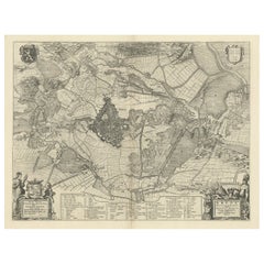
Antique Map of the Siege of Syracuse, Sicilia, Italy, 'ca.1675'
About the Item
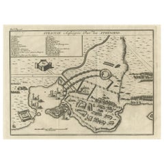
Antique map titled 'Syracus beseeged by the Athenians.' This original uncommon antique map shows the siege of Syracuse, Italy, by the Athenians. Key top left.
The siege of Syracuse by the Roman Republic took place in 213–212 BC. The Romans successfully stormed the Hellenistic city of Syracuse after a protracted siege, giving them control of the entire island of Sicily. During the siege, the city was protected by weapons developed by Archimedes.
Source unknown/to be determined.
Artists and Engravers: Anonymous.
- Dimensions:Height: 12.6 in (32 cm)Width: 15.56 in (39.5 cm)Depth: 0 in (0.02 mm)
- Materials and Techniques:
- Period:1670-1679
- Date of Manufacture:circa 1675
- Condition:Condition: Good, given age. Original middle fold as issued. General age-related toning and/or occasional minor defects from handling. Please study image carefully.
- Seller Location:Langweer, NL
- Reference Number:
About the Seller
5.0
Platinum Seller
These expertly vetted sellers are 1stDibs' most experienced sellers and are rated highest by our customers.
Established in 2009
1stDibs seller since 2017
1,929 sales on 1stDibs
Typical response time: <1 hour
- ShippingRetrieving quote...Ships From: Langweer, Netherlands
- Return PolicyA return for this item may be initiated within 14 days of delivery.
More From This SellerView All
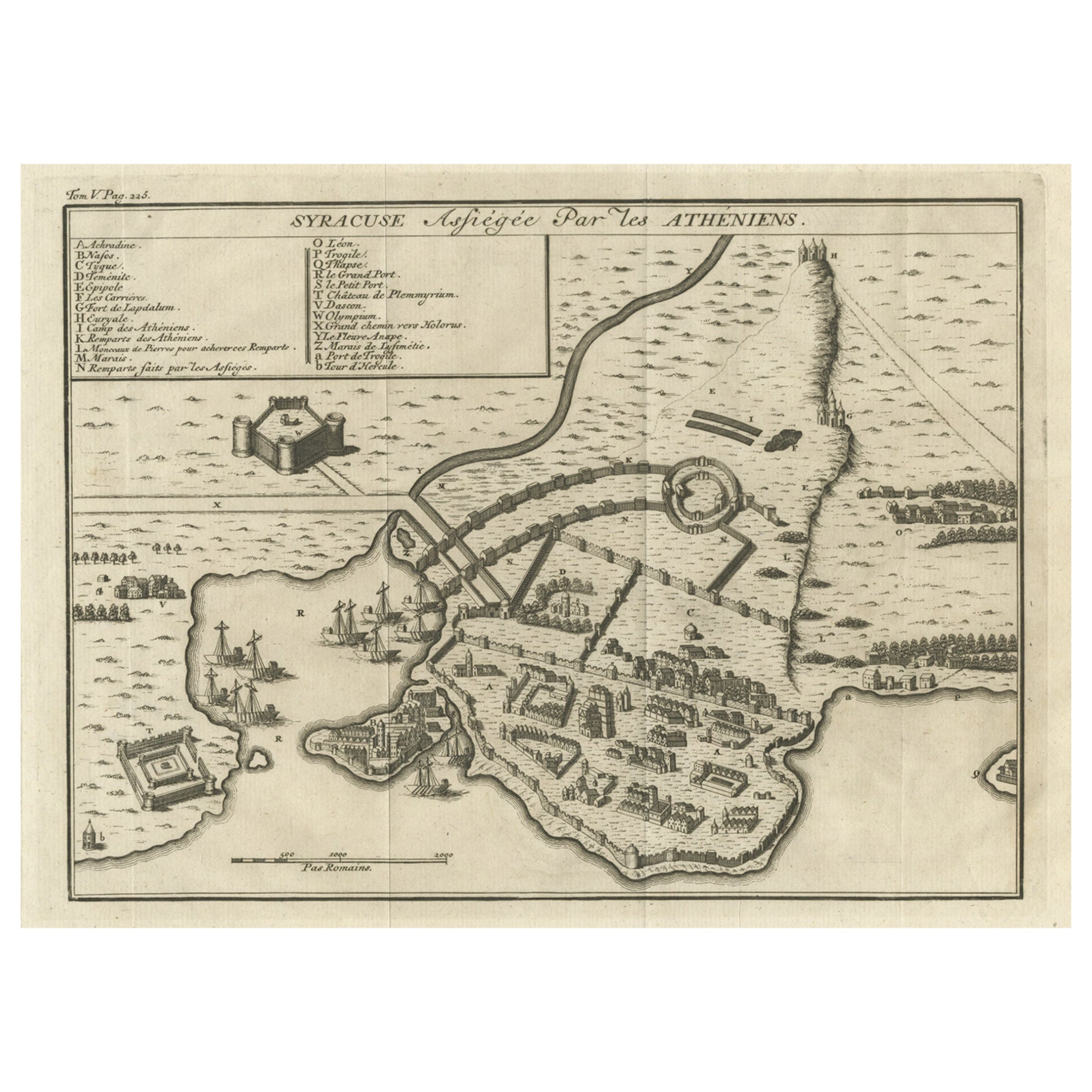
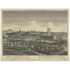
- Old Copper Engraving of the Siege of Syracuse, Sicily, Italy, Published, ca.1740Located in Langweer, NLAntique print titled 'Syracuse, Assiégée par les Atheniens'. Old print of the siege of Syracuse, Sicily, Italy. Source unknown, to be determined. The siege of Syracuse by the...Category
Antique 1740s Maps
MaterialsPaper
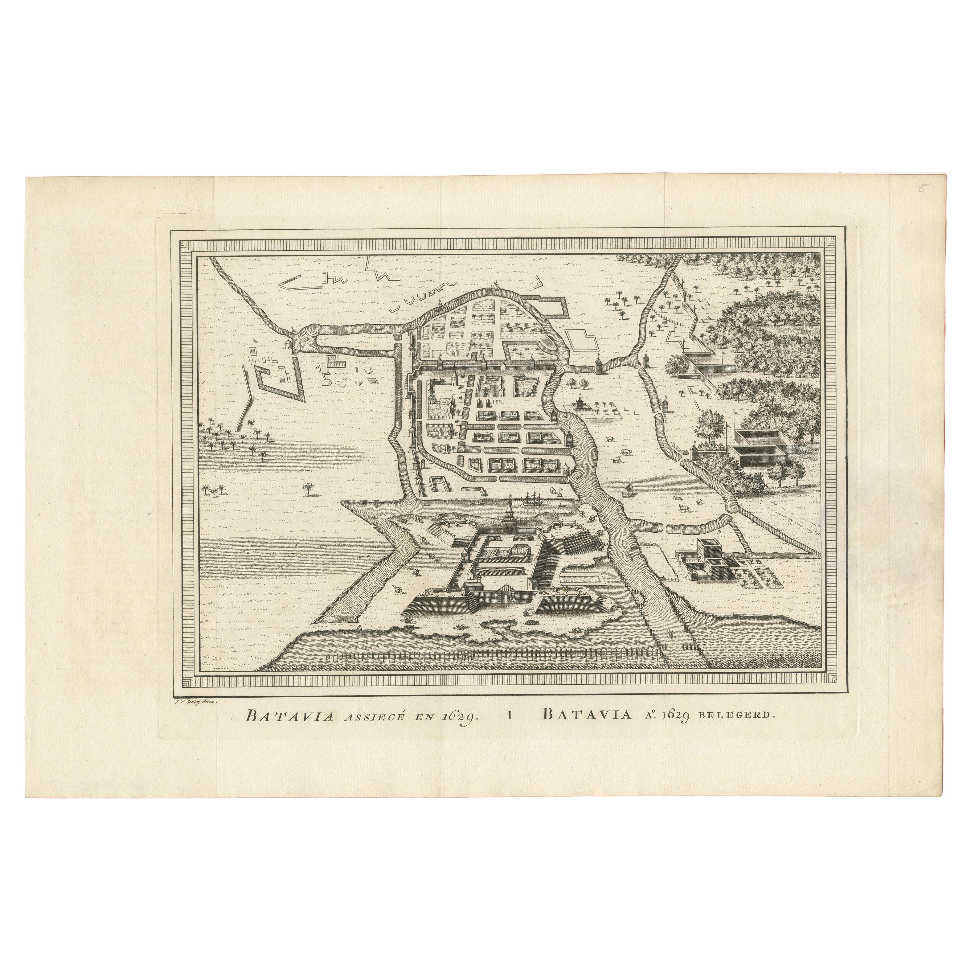
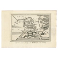
- Antique Map of the Siege of Batavia by Van Schley 'c.1750'Located in Langweer, NLAntique map titled 'Batavia assiecé en 1629 - Batavia 1629 belegerd'. Bird's eye view map of the siege of Batavia in 1629, Jakarta, Indonesia. This print originates from the Dutch ed...Category
Antique Mid-18th Century Prints
MaterialsPaper
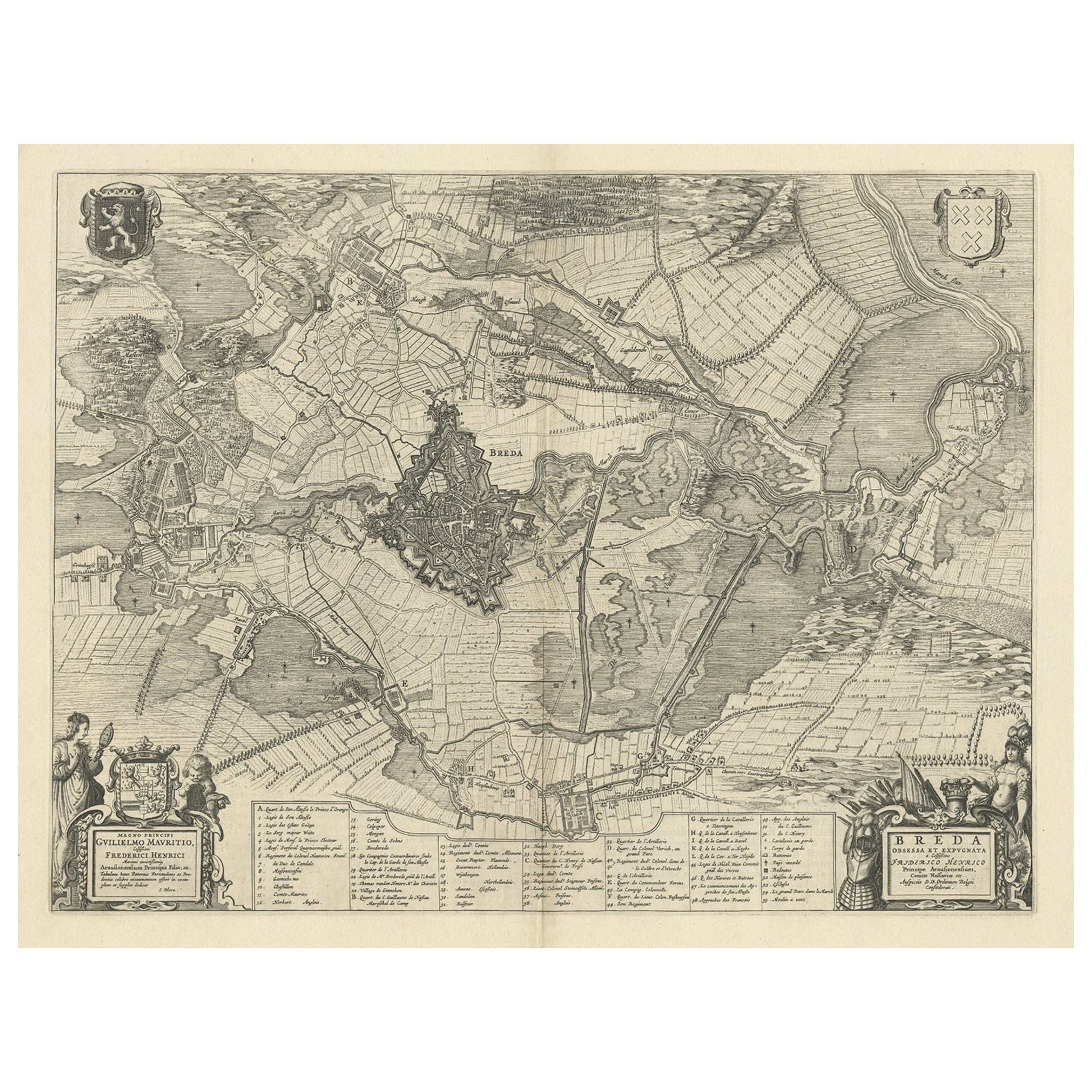
- Antique Map of the Siege of Breda, City in the Netherlands by Blaeu, 1649Located in Langweer, NLAntique map titled 'Breda obsessa et expugnata a Celsissimo Frederico Henrico'. Old map of the city of Breda, the Netherlands. It shows the Siege of Breda in 1637. Originates fro...Category
Antique 17th Century Maps
MaterialsPaper
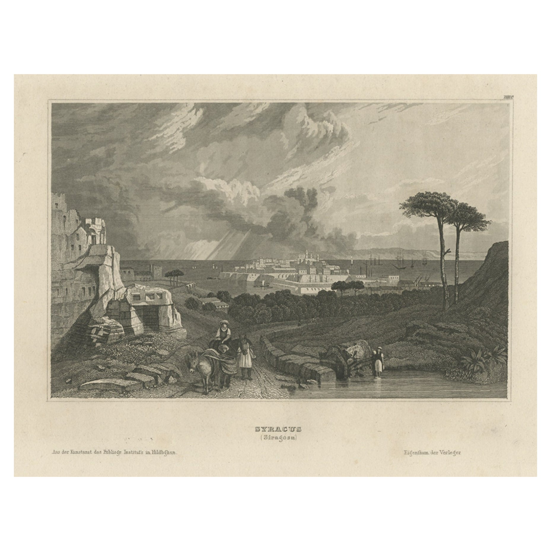
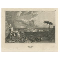
- Antique View of Syracuse, Sicily, Italy, 1837Located in Langweer, NLAntique print titled 'Syracus'. View of Syracuse, Sicily, Italy. Originates from 'Meyers Universum'. Artists and Engravers: Joseph Meyer (May 9, 1796 - June 27, 1856) was a Germa...Category
Antique 1830s Prints
MaterialsPaper
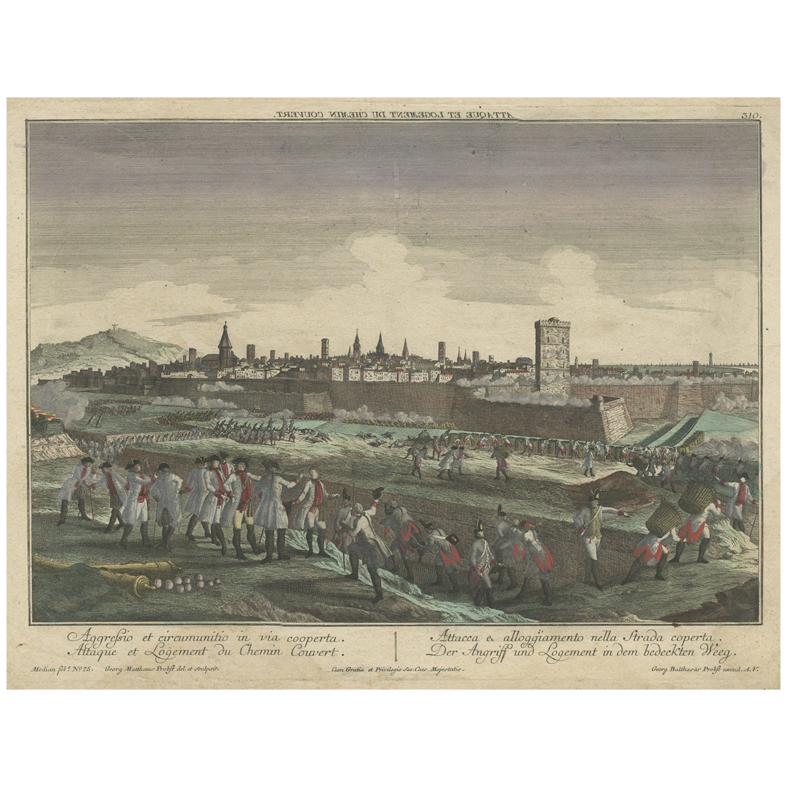
- Optical View Depicting the Siege of Barcelona, Spain, ca.1765Located in Langweer, NLAntique print Barcelona titled 'Aggressio et Circumunitio in via cooperta'. Optical view depicting the siege of Barcelona (Spain) which took place between 25 July 1713 and 11 September 1714. With Latin, French, Italian and German caption. Artists and Engravers: Georg Balthasar Probst (1732 - 1801) was a German artist, engraver and publisher in Augsburg. The Siege of Barcelona (Catalan: Setge de Barcelona) was a battle at the end of the War of Spanish Succession, which pitted Archduke Charles of Austria (backed by Great Britain and the Netherlands, i.e. the Grand Alliance) against Philip V of Spain, backed by France in a contest for the Spanish crown. The surrender of the pro-Archduke forces to the Franco-Spanish army in 1714 was not only the end of the war, but also a phase in the centralization of various monarchies on the European continent which had been going on for two centuries. With the War of the Spanish Succession completed, Spain evolved from a personal union of different states to a centralized kingdom. The defenders of the city were buried in a cemetery, now a plaça (Catalan: square) called Fossar de les Moreres, where Catalans gather every 11 September, known as the National Day of Catalonia or la Diada. The former market hall Mercat del Born covers archaeological ruins which were part of the La Ribera district of Barcelona that was demolished after the defeat of Catalonia in 1714. The alleged abandonment of the Catalans defenders of Barcelona was one of the criticisms made by his opponents during the British Parliament...Category
Antique 1760s Prints
MaterialsPaper
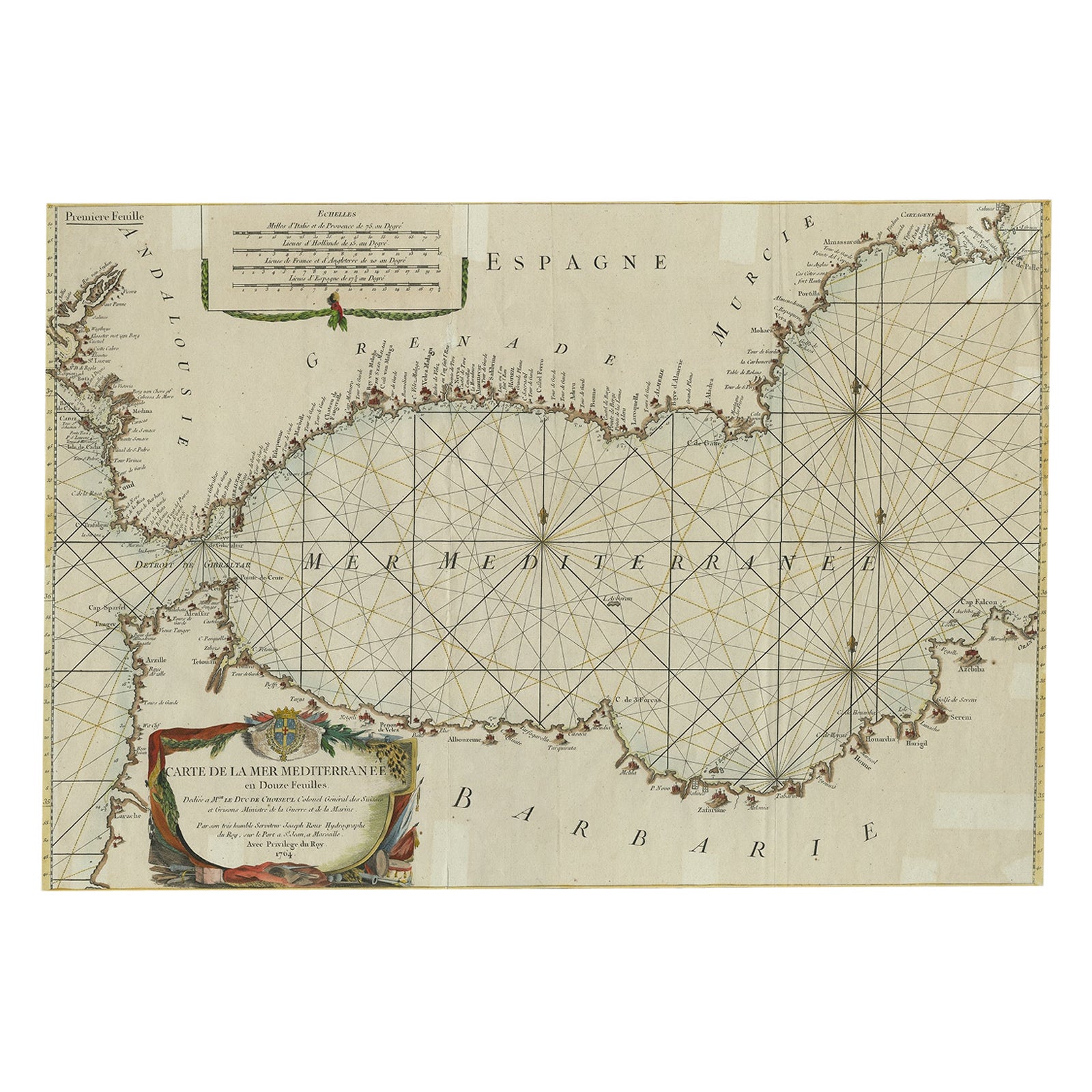
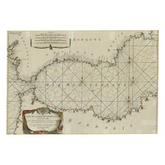
- Large Decorative Antique Map of the Mediterranean, ca.1770Located in Langweer, NLAntique map titled 'Carte de la Mer Mediterranee en Douze Feuilles'. First map out of twelve fine engraved double-page and folding maps that join to create a large wall map...Category
Antique 1770s Maps
MaterialsPaper
You May Also Like
- Original Antique Map of Italy. Arrowsmith. 1820Located in St Annes, LancashireGreat map of Italy Drawn under the direction of Arrowsmith Copper-plate engraving Published by Longman, Hurst, Rees, Orme and Brown, 1820 Unframed.Category
Antique 1820s English Maps
MaterialsPaper
- Antique Map of Italy by Andriveau-Goujon, 1843By Andriveau-GoujonLocated in New York, NYAntique Map of Italy by Andriveau-Goujon, 1843. Map of Italy in two parts by Andriveau-Goujon for the Library of Prince Carini at Palazzo Carini i...Category
Antique 1840s French Maps
MaterialsLinen, Paper
- Map of the Republic of GenoaLocated in New York, NYFramed antique hand-coloured map of the Republic of Genoa including the duchies of Mantua, Modena, and Parma. Europe, late 18th century. Dimension: 25...Category
Antique Late 18th Century European Maps
- Antique Map of Principality of MonacoBy Antonio Vallardi EditoreLocated in Alessandria, PiemonteST/619 - "Old Geographical Atlas of Italy - Topographic map of ex-Principality of Monaco" - ediz Vallardi - Milano - A somewhat special edition ---Category
Antique Late 19th Century Italian Other Prints
MaterialsPaper
- Original Antique Map of The World by Thomas Clerk, 1817Located in St Annes, LancashireGreat map of The Eastern and Western Hemispheres On 2 sheets Copper-plate engraving Drawn and engraved by Thomas Clerk, Edinburgh. Published by Mackenzie And Dent, 1817 ...Category
Antique 1810s English Maps
MaterialsPaper
- Antique 18th Century Map of the Province of Pensilvania 'Pennsylvania State'Located in Philadelphia, PAA fine antique of the colony of Pennsylvania. Noted at the top of the sheet as a 'Map of the province of Pensilvania'. This undated and anonymous map is thought to be from the Gentleman's Magazine, London, circa 1775, although the general appearance could date it to the 1760's. The southern boundary reflects the Mason-Dixon survey (1768), the western boundary is placed just west of Pittsburgh, and the northern boundary is not marked. The map has a number of reference points that likely refer to companion text and appear to be connected to boundaries. The western and southern boundaries are marked Q, R, S, for example. A diagonal line runs from the Susquehanna R to the Lake Erie P. A broken line marked by many letters A, B, N, O, etc., appears in the east. There are no latitude or longitude markings, blank verso. Framed in a shaped contemporary gilt wooden frame and matted under a cream colored matte. Bearing an old Graham Arader Gallery...Category
Antique 18th Century British American Colonial Maps
MaterialsPaper


Recently Viewed
View AllMore Ways To Browse
Collecting Antique Keys
Keys Collectible Antique
Siege Of
Syracuse Used Furniture
Siege Antique
Antique Roman Map
Roman Map
Map Of Sicily
Sicily Map
Syracuse Antique
Antique Maps Of Sicily
Antique Sicily Map
Antique Map Sicily
18th Century Southern Antiques
Antique French Globe
South African Antique Furniture
Antique Furniture South Africa
Used Booksellers