Items Similar to Bird's-Eye Views of Dunkerque, Gravelines, and Bourbourg by Braun and Hogenberg

Want more images or videos?
Request additional images or videos from the seller
1 of 8
Bird's-Eye Views of Dunkerque, Gravelines, and Bourbourg by Braun and Hogenberg
$460.09
$575.1120% Off
£342.44
£428.0520% Off
€384
€48020% Off
CA$630.20
CA$787.7620% Off
A$700.92
A$876.1620% Off
CHF 366
CHF 457.5020% Off
MX$8,529.51
MX$10,661.8920% Off
NOK 4,674.39
NOK 5,842.9920% Off
SEK 4,383.76
SEK 5,479.7020% Off
DKK 2,923.26
DKK 3,654.0720% Off
Shipping
Retrieving quote...The 1stDibs Promise:
Authenticity Guarantee,
Money-Back Guarantee,
24-Hour Cancellation
About the Item
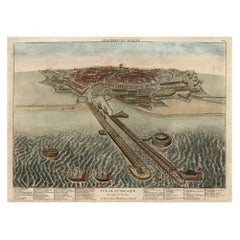
Bird's-Eye Views of Dunkerque, Gravelines, and Bourbourg by Braun and Hogenberg, 1597
This antique print, published in 1597 by Braun and Hogenberg, showcases three detailed bird's-eye views of Dunkerque (Dunkirk), Gravelines, and Bourbourg. Taken from their monumental work *Civitates Orbis Terrarum*, these views capture the strategic importance and architectural highlights of these northern French towns during the late 16th century.
The upper section features Dunkerque, emphasizing its harbor and coastal location. Notable structures include the 15th-century chapel of Notre-Dame-des-Dunes, the belfry, and the 16th-century church of Saint-Éloy. Once a fishing village, Dunkerque grew into a trading hub but was often fought over due to its strategic position, making it a haven for pirates.
The middle section presents Gravelines, a fortified town on the River Aa. Surrounded by broad moats and strong walls, its position made it a significant military stronghold. Historical references include the fortifications begun by Charles V and the town's proximity to the famous naval battle where Sir Francis Drake defeated the Spanish Armada in 1588.
The lower section illustrates Bourbourg, a smaller fortified town with the church of Saint Jean Baptiste at its heart. The town's humble marshland origins as "Broecborc" are noted, alongside its historical role in resisting French advances during English possession.
- Title: Bird's-Eye Views of Dunkerque, Gravelines, and Bourbourg
- Cartographers: Braun and Hogenberg
- Source: *Civitates Orbis Terrarum*
- Date of First Edition: 1575
- Date of This Map: 1597
- Description: Three bird's-eye views of Dunkerque, Gravelines, and Bourbourg, highlighting their fortifications, harbors, and key architectural features. Provides a detailed glimpse into the geopolitical importance of the region during the late 16th century.
- Condition: Strong impression with sharp details. Light age-toning and minor handling wear on the edges. No tears or significant staining, with clean margins. Overall, in excellent condition for a late 16th-century print.
- Significance: From the renowned *Civitates Orbis Terrarum*, one of the most important urban atlases of the Renaissance, celebrated for its artistic detail and historical insights.
- Dimensions:Height: 15.75 in (40 cm)Width: 20.28 in (51.5 cm)Depth: 0.01 in (0.2 mm)
- Materials and Techniques:Paper,Engraved
- Period:
- Date of Manufacture:1597
- Condition:Good condition: Strong impression with sharp details. Light age-toning and minor handling wear on the edges. No tears or significant staining, with clean margins. Overall, in excellent condition for a late 16th-century print.
- Seller Location:Langweer, NL
- Reference Number:Seller: BG-13892-41stDibs: LU3054342438702
About the Seller
5.0
Recognized Seller
These prestigious sellers are industry leaders and represent the highest echelon for item quality and design.
Platinum Seller
Premium sellers with a 4.7+ rating and 24-hour response times
Established in 2009
1stDibs seller since 2017
2,508 sales on 1stDibs
Typical response time: <1 hour
- ShippingRetrieving quote...Shipping from: Langweer, Netherlands
- Return Policy
Authenticity Guarantee
In the unlikely event there’s an issue with an item’s authenticity, contact us within 1 year for a full refund. DetailsMoney-Back Guarantee
If your item is not as described, is damaged in transit, or does not arrive, contact us within 7 days for a full refund. Details24-Hour Cancellation
You have a 24-hour grace period in which to reconsider your purchase, with no questions asked.Vetted Professional Sellers
Our world-class sellers must adhere to strict standards for service and quality, maintaining the integrity of our listings.Price-Match Guarantee
If you find that a seller listed the same item for a lower price elsewhere, we’ll match it.Trusted Global Delivery
Our best-in-class carrier network provides specialized shipping options worldwide, including custom delivery.More From This Seller
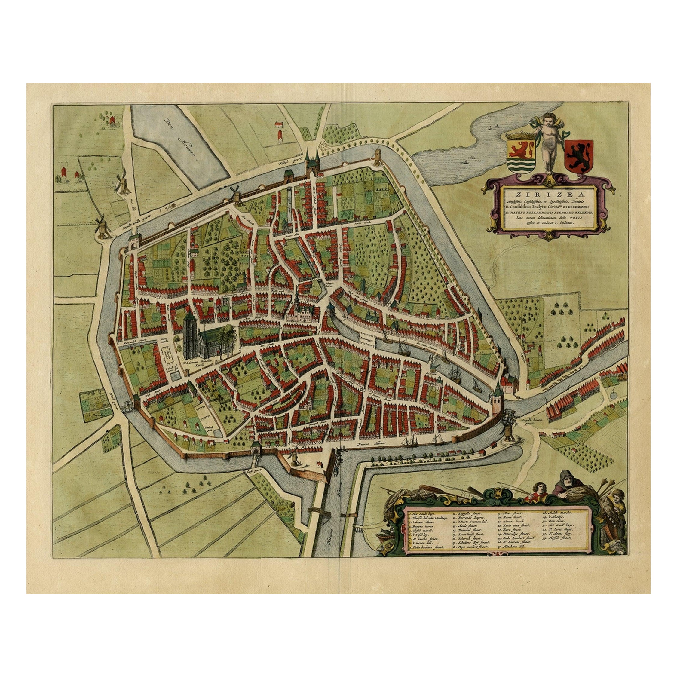
View AllAntique Bird's-eye View Plan of Zierikzee in Zeeland, The Netherlands, 1649
Located in Langweer, NL
Antique print, titled: 'Zirizea.' - A bird's-eye view plan of Zierikzee in The Netherlands, with key to locations and coats of arms. After Matheo Rollando and Stephano Bellemo. Latin tekst on verso. From the city Atlas: 'Toneel der Steeden' published by Joan Blaeu...
Category
Antique 1640s Maps
Materials
Paper
$1,102 Sale Price
20% Off
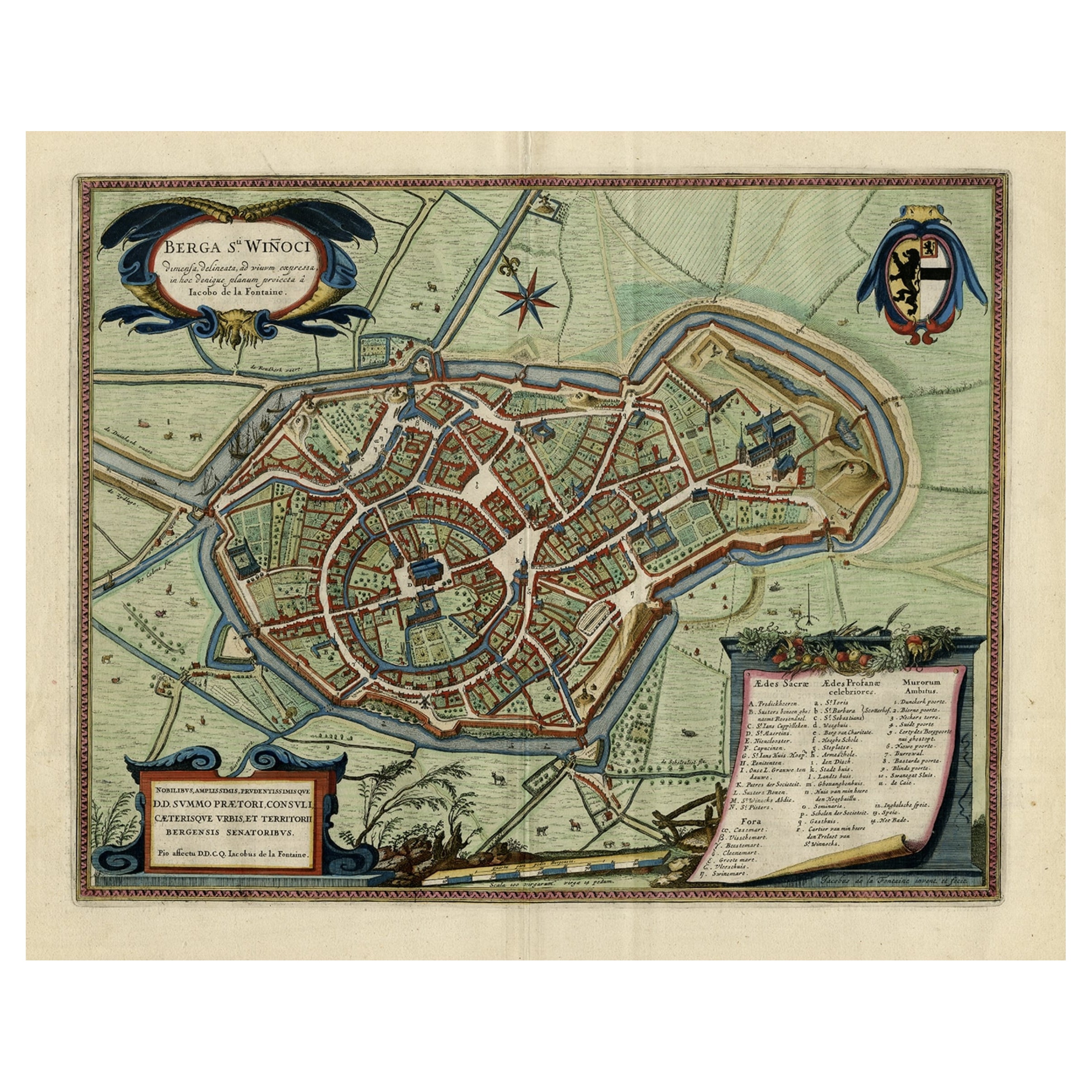
Original Old Bird's-Eye View Plan of Sint-Winoksbergen or Bergen in France, 1649
Located in Langweer, NL
Antique map titled 'Berga Sti Winoci.' - Bird's-eye view plan of Sint-Winoksbergen in France, with key to locations and coats of arms. Text in Dutch on verso. This plan originates from the famous city Atlas: 'Toneel der Steeden' published by Joan Blaeu...
Category
Antique 1640s Maps
Materials
Paper
$1,389 Sale Price
20% Off
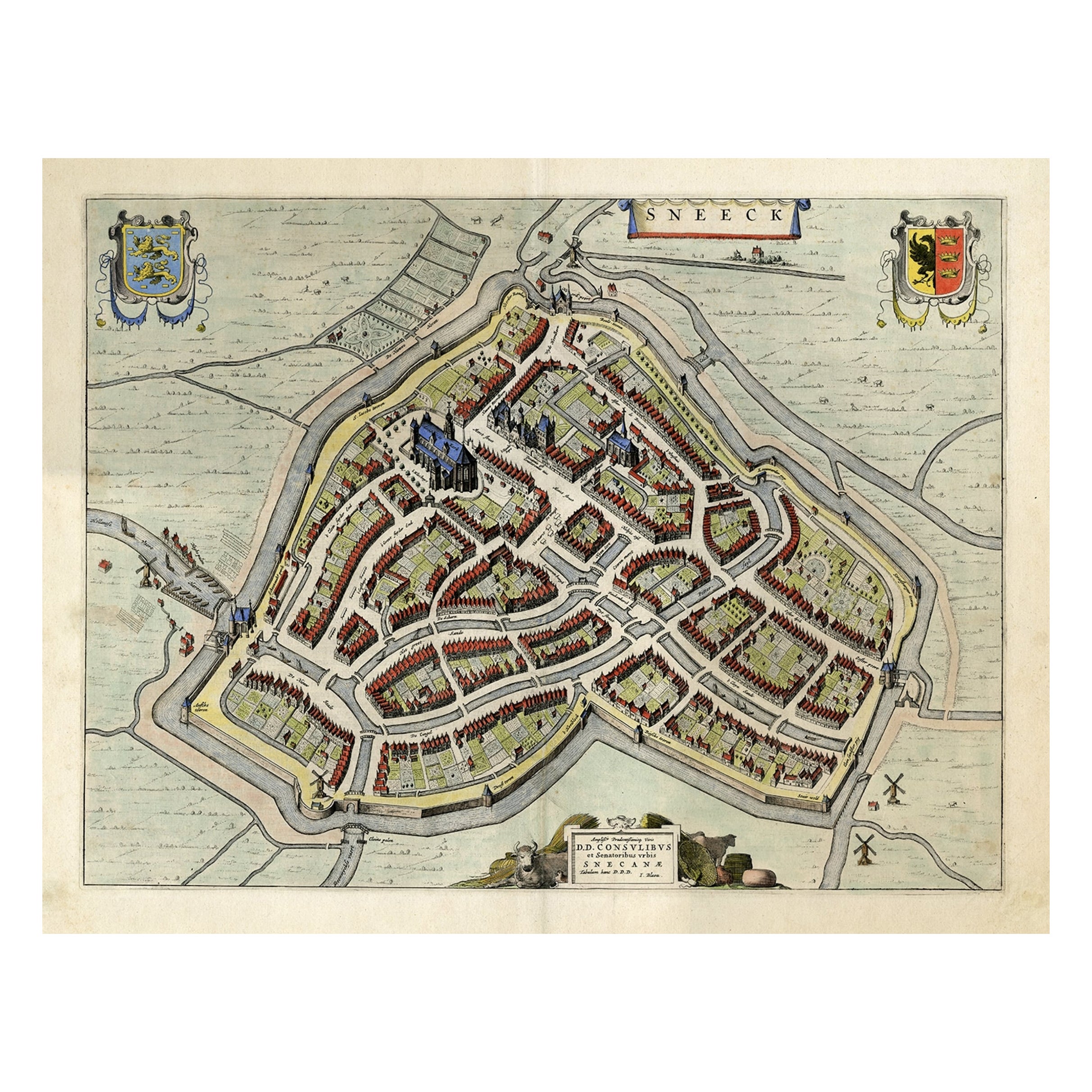
Original Old Bird's-eye View plan of Sneek, Friesland, The Netherlands, 1649
Located in Langweer, NL
Antique map titled: 'Sneeck.' Bird's-eye view plan of Sneek, Friesland, The Netherlands. Text in Latin on verso. This plan originates from the famous city Atlas: 'Toneel der Steeden'...
Category
Antique 1640s Maps
Materials
Paper
$1,102 Sale Price
20% Off
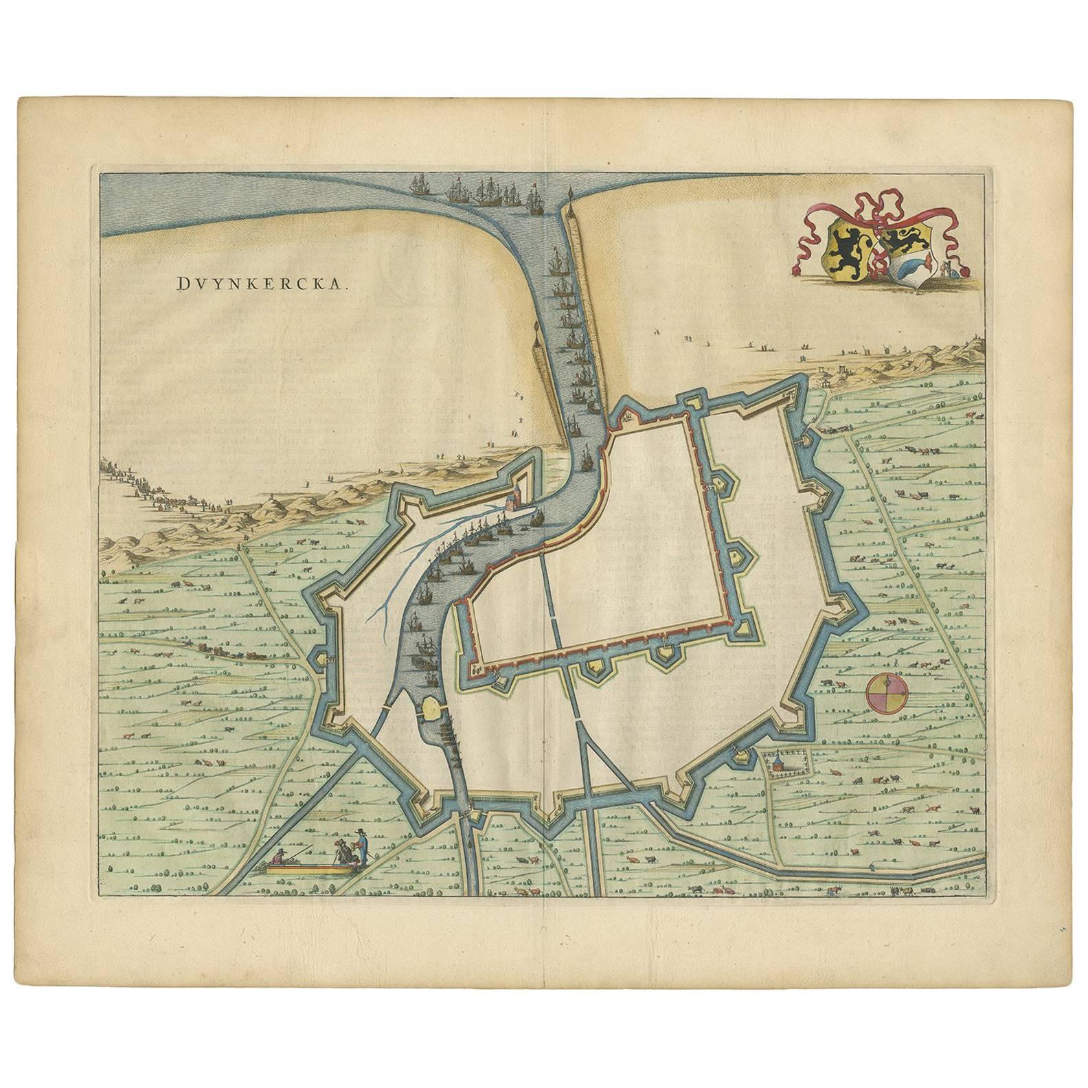
Antique Map of Dunkirk 'France' by J. Blaeu, 1649
Located in Langweer, NL
Antique map titled 'Duynkercka'. Published by J. Blaeu, 1649. Dutch text on verso.
Category
Antique Mid-17th Century Maps
Materials
Paper

$503 Sale Price
20% Off
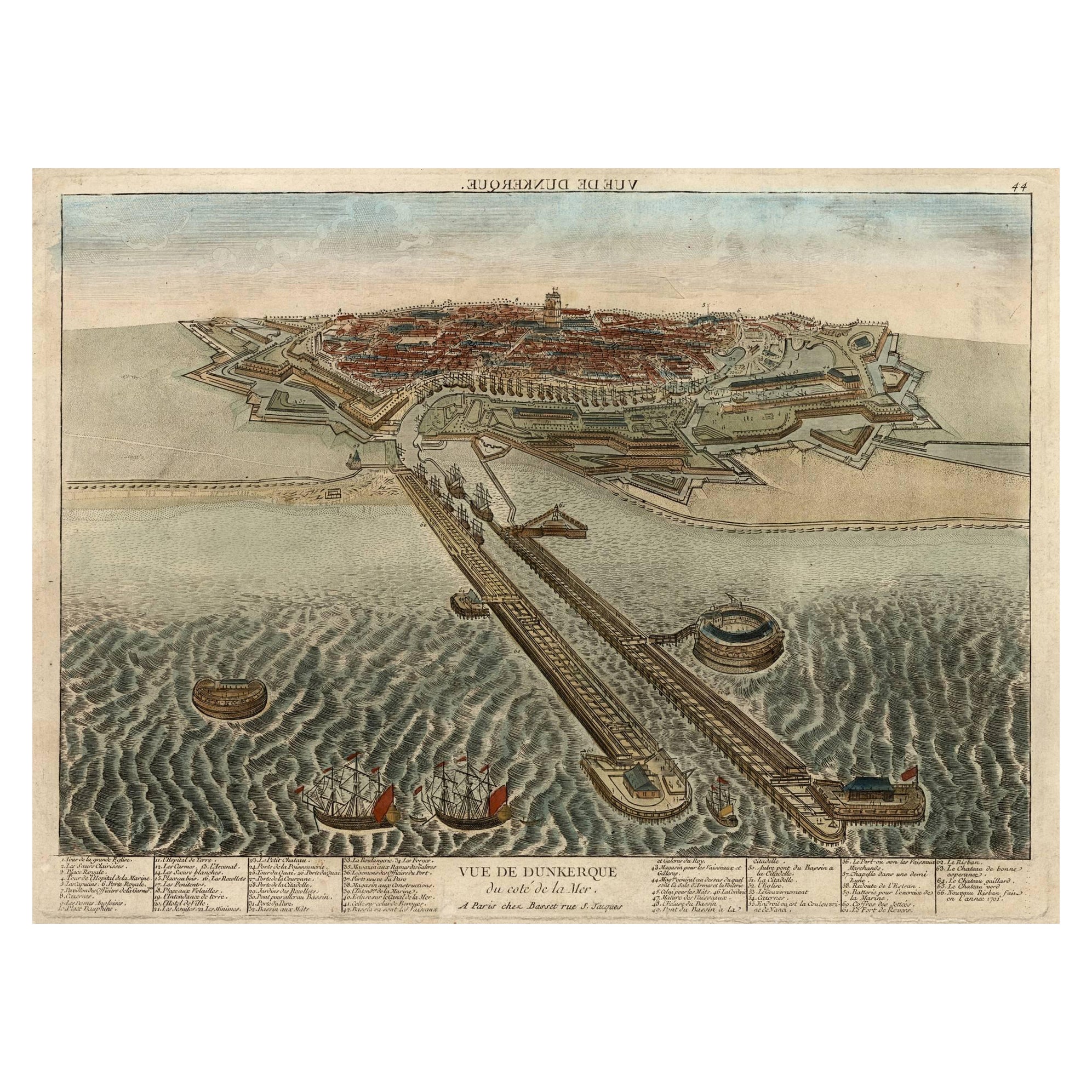
Spectacular 1770 Bird's-Eye View of Dunkirk Harbor by Basset, with 66 Landmarks
Located in Langweer, NL
This engraving, titled *Vue de Dunkerque du coté de la Mer*, is a spectacular bird's-eye view of Dunkirk from the sea, published by Basset around 1770.
It provides a detailed panor...
Category
Antique 1770s Maps
Materials
Paper
$469 Sale Price
20% Off
Decorative Bird's-Eye View Plan of Ieper or Ypres in Belgium, 1649
Located in Langweer, NL
Antique print, titled: 'Ypra.'
Bird's-eye view plan of Ieper / Ypres in Belgium. With key to locations and coats of arms. Text in Latin on verso. This plan originates from the famous city Atlas: 'Toneel der Steeden' published by Joan Blaeu...
Category
Antique 1640s Maps
Materials
Paper
$1,389 Sale Price
20% Off
You May Also Like
18th Century Map Engraving - Newport, a Strong Sea-Port Town in Flanders
Located in Corsham, GB
A map of Nieuwpoort, anglicised to 'Newport', in northern Belgium. There is a panorama in the upper quarter depicting major landmarks. Below is a plan of the town, including its strong defences and ships at the port in the lower register. Inscribed with the title in plate to the lower edge, 'Newport a Strong Sea-Port Town...
Category
18th Century More Prints
Materials
Engraving

$269 Sale Price
20% Off
Map of Groningen - Etching by George Braun - Late 16th Century
Located in Roma, IT
This map of Groninga is an original etching realized by George Braun and Franz Hogenberg, and part of the series "Civitates Orbis Terrarum".
The state of preservation of the artwork...
Category
16th Century Figurative Prints
Materials
Etching

17th Century Topographical Engraving Nantes & St. Malo, France, by Iohan Peeters
Located in New York, NY
The ancient city of Saint Malo in North Western France has long been associated with adventure on the high seas, piracy and exploration. It was the birthplace of several important in...
Category
Antique 17th Century Dutch Maps
Materials
Paper

1597 German Map of Alexandria by Georg Braun and Frans Hogenberg
By Georg Braun and Frans Hogenberg
Located in Chapel Hill, NC
1597 Map of Alexandria by Georg Braun and Frans Hogenberg, Germany. From "Civitas Orbis Terrarum", part 2, published in Cologne by Bertram Buchholz. Printed in 2 parts. Title: "Alexa...
Category
Antique 16th Century German Renaissance Maps
Materials
Paper

1590 Ortelius Map of Calais and Vermandois, France and Vicinity Ric.a014
Located in Norton, MA
1590 Ortelius map of
Calais and Vermandois, France and Vicinity
Ric.a014
Two rare regional Abraham Ortelius maps on a single folio sheet. Left map, entitled Caletensium, depic...
Category
Antique 16th Century Dutch Maps
Materials
Paper

Utrecht, Antique Map from "Civitates Orbis Terrarum"
By Franz Hogenberg
Located in Roma, IT
Braun G., Hogenberg F., Traiectum or Utrecht, from the collection Civitates Orbis Terrarum, Cologne, T. Graminaeus, 1572-1617.
Very fine B/W aquatint showing a view of Utrecht, with...
Category
16th Century Landscape Prints
Materials
Etching

More Ways To Browse
English 16th Century Furniture
Antique Key Heart
Antique Fishing Collectables
Spanish Armada
Sir Francis Drake
Elios Chair
Plata Lappas
Red Retro Dining Set
Antique Bouquet
Antique Silver Glasses Case
Carlo Scarpa 1934 Chairs
Christofle Marly
1900 Antique Chairs
Glass Table Italian Round
Mid Century Colonial
Alvar Aalto Poster
Geometric Metal Table
Post Modern High Chairs