Items Similar to Colorfull Antique Map of Africa with Algeria Inset – Stieler Atlas 1858


Want more images or videos?
Request additional images or videos from the seller
1 of 6
Colorfull Antique Map of Africa with Algeria Inset – Stieler Atlas 1858
$447.88
£337.34
€380
CA$617.64
A$693.89
CHF 362.56
MX$8,469.28
NOK 4,603.45
SEK 4,333.18
DKK 2,892.42
About the Item
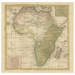
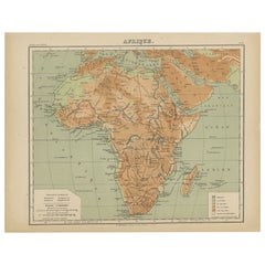
Antique Map of Africa with Algeria Inset – Stieler Atlas 1858
This antique map of Africa, engraved by F. von Stülpnagel and published by Justus Perthes in 1858, is a finely detailed and historically valuable depiction of the African continent during the mid-19th century. It was issued as part of the influential "Stieler’s Hand-Atlas," one of the most comprehensive and scientifically accurate atlases of its time.
The map covers the entire African continent, from the Mediterranean in the north to the Cape of Good Hope in the south, and from the Canary Islands and Atlantic Ocean in the west to Madagascar and the Indian Ocean in the east. A detailed inset in the lower left corner presents the northern Algerian coast, including the cities of Algiers, Oran, and Constantine, with considerable topographical detail.
At the time of publication, much of Africa remained unexplored by Europeans, and this map reflects the contemporary geographic understanding, with interior regions such as “Hoch-Afrika” (High Africa) and “Sahara” still largely unknown or labeled with speculative geography. Notable colonial territories are marked, such as British Cape Colony, French Algeria, and Portuguese Angola and Mozambique. The Nile, Niger, and Congo rivers are shown in partial detail, and important trade routes and caravan paths are indicated.
Color coding is used to delineate colonial possessions and ethnic regions, with a legend in the lower right corner. Mountain ranges, deserts, rivers, and coastal features are all finely engraved, demonstrating the precision of Stülpnagel’s work. The map’s typography and engraving quality are exemplary, combining scientific accuracy with artistic finesse.
This map is an excellent historical document for collectors interested in Africa, European colonial history, or antique cartography. It captures a continent on the cusp of exploration, with many regions still shrouded in mystery according to European knowledge of the time.
Condition report:
Very good condition. Light age toning. Original centerfold as issued. Small foxing marks near the lower edge and light wear to the outer margins. Colors remain vibrant and crisp.
Framing tips:
A dark walnut or black frame with a wide off-white mat will complement the engraving’s subtle coloring and highlight its historical character. This piece would also pair well with other continental maps from the same series for a gallery wall.
Technique: Engraving with original hand coloring
Maker: F. von Stülpnagel, Gotha, Justus Perthes, 1858
- Dimensions:Height: 14.77 in (37.5 cm)Width: 17.88 in (45.4 cm)Depth: 0.01 in (0.2 mm)
- Materials and Techniques:Paper,Engraved
- Place of Origin:
- Period:
- Date of Manufacture:1858
- Condition:Very good condition. Light age toning. Original centerfold as issued. Small foxing marks near the lower edge and light wear to the outer margins. Colors remain vibrant and crisp.
- Seller Location:Langweer, NL
- Reference Number:Seller: BG-05552-471stDibs: LU3054346101402
About the Seller
5.0
Recognized Seller
These prestigious sellers are industry leaders and represent the highest echelon for item quality and design.
Platinum Seller
Premium sellers with a 4.7+ rating and 24-hour response times
Established in 2009
1stDibs seller since 2017
2,533 sales on 1stDibs
Typical response time: <1 hour
- ShippingRetrieving quote...Shipping from: Langweer, Netherlands
- Return Policy
Authenticity Guarantee
In the unlikely event there’s an issue with an item’s authenticity, contact us within 1 year for a full refund. DetailsMoney-Back Guarantee
If your item is not as described, is damaged in transit, or does not arrive, contact us within 7 days for a full refund. Details24-Hour Cancellation
You have a 24-hour grace period in which to reconsider your purchase, with no questions asked.Vetted Professional Sellers
Our world-class sellers must adhere to strict standards for service and quality, maintaining the integrity of our listings.Price-Match Guarantee
If you find that a seller listed the same item for a lower price elsewhere, we’ll match it.Trusted Global Delivery
Our best-in-class carrier network provides specialized shipping options worldwide, including custom delivery.More From This Seller
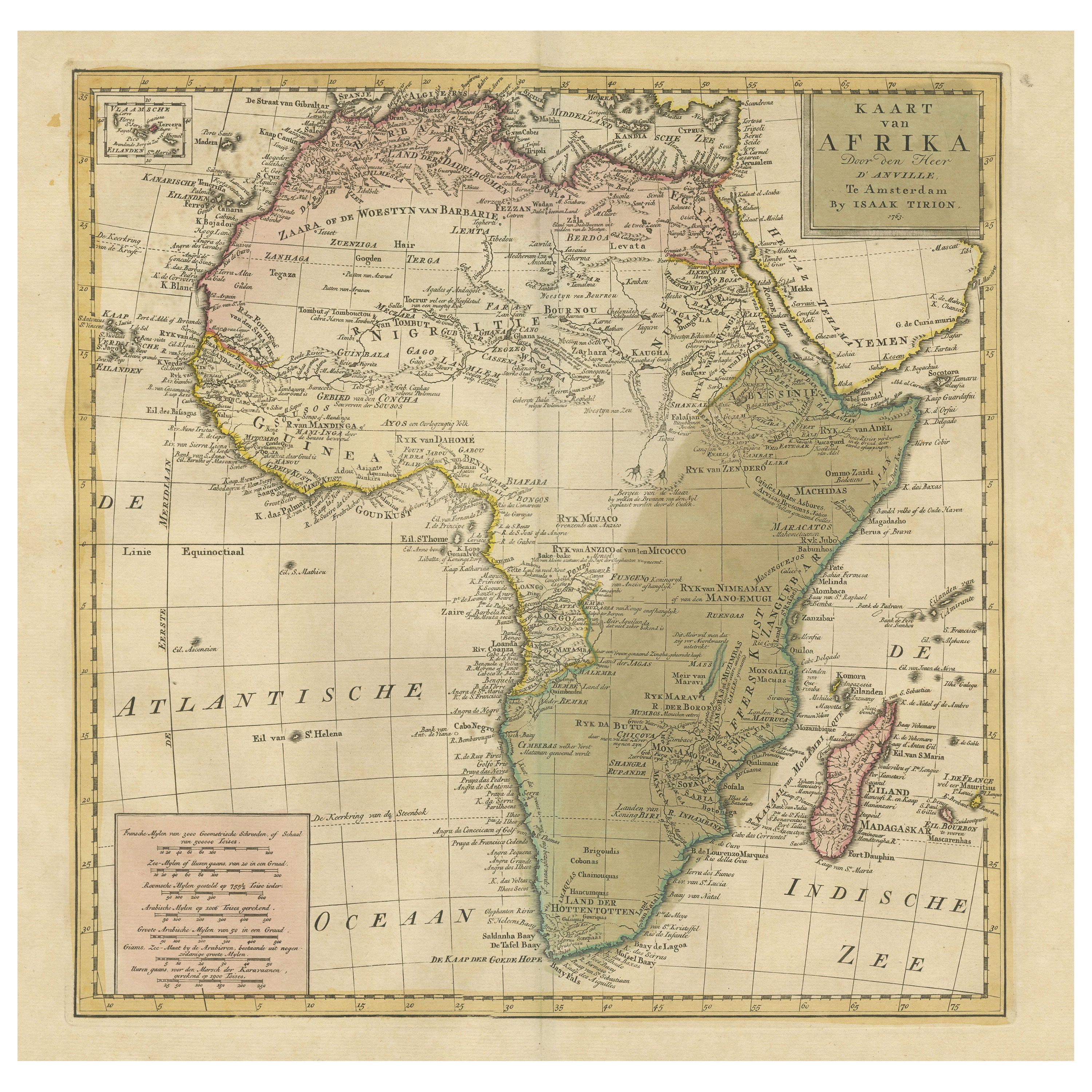
View AllAntique Map of Africa with Original Hand Coloring
Located in Langweer, NL
Antique map titled 'Kaart van Afrika door den Heer d'Anville'. Detailed original old map of Africa, with very small inset map titled 'Vlaamsche Eilanden', which shows the Azores. Pub...
Category
Antique Mid-18th Century Maps
Materials
Paper
$735 Sale Price
20% Off
Antique Map of Africa by A & C, Black, 1870
Located in Langweer, NL
Antique map titled 'Africa'. Original antique map of Africa. This map originates from ‘Black's General Atlas of The World’. Published by A & C. Black, 1870.
Category
Antique Late 19th Century Maps
Materials
Paper

$259 Sale Price
20% Off
Antique Map of Africa, Highlighting Colonial Divisions, Geographic Features 1903
Located in Langweer, NL
Title: Antique Map of Africa, 1903, Highlighting Colonial Divisions and Geographic Features
Description: This antique map, titled "Africa," was engraved and published in 1903 by W. ...
Category
Early 20th Century Maps
Materials
Paper

Antique Map of Africa with European Language Borders, 1852
Located in Langweer, NL
Antique map titled 'Afrika'. Map of Africa. This map originates from 'School-Atlas van alle deelen der Aarde' by Otto Petri.
Artists and Engravers: Published by A. Baedeker (Otto...
Category
Antique 19th Century Maps
Materials
Paper

$150 Sale Price
20% Off
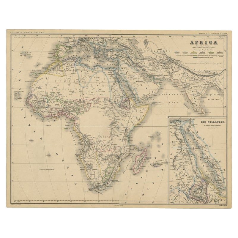
Antique Map of the African Continent with Inset of the Nile River Delta, c.1870
Located in Langweer, NL
Antique map titled 'Africa'. Old map of the African continent. This map originates from 'H. Kiepert's Kleiner Atlas der Neueren Geographie für Schule...
Category
Antique 19th Century Maps
Materials
Paper

$301 Sale Price
20% Off
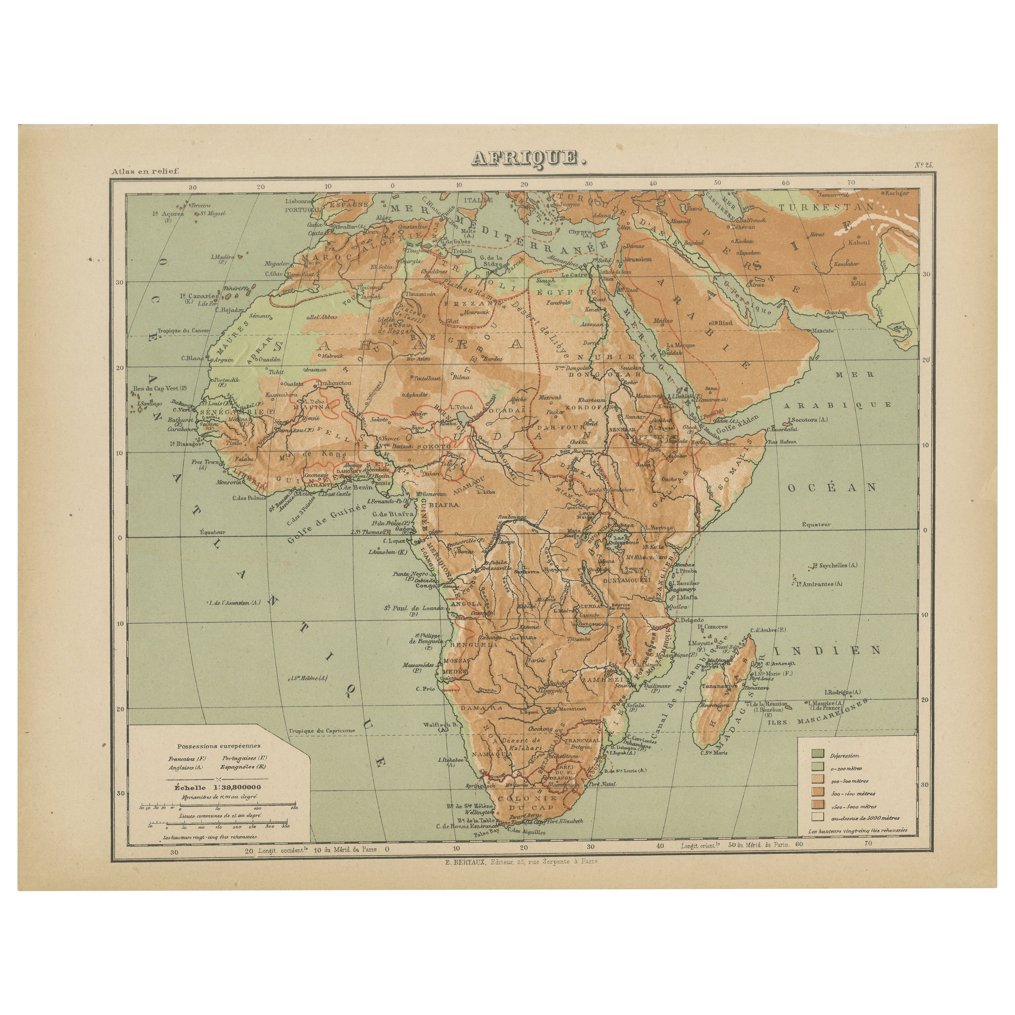
Relief Atlas Map of Africa by Hachette – Antique c.1883 French Map
Located in Langweer, NL
Antique Map of Africa – Relief Atlas Map by Hachette, circa 1880
Description:
This is an attractive antique map titled “Afrique,” published by Hachette...
Category
Antique Late 19th Century Maps
Materials
Paper
You May Also Like
Original Antique Map of Africa by Dower, circa 1835
Located in St Annes, Lancashire
Nice map of Africa
Drawn and engraved by J.Dower
Published by Orr & Smith. C.1835
Unframed.
Free shipping
Category
Antique 1830s English Maps
Materials
Paper

Large Original Antique Map of Africa. C.1900
Located in St Annes, Lancashire
Fabulous map of Africa
Original color.
Engraved and printed by the George F. Cram Company, Indianapolis.
Published, C.1900.
Unframed.
Free shipping.
Category
Antique 1890s American Maps
Materials
Paper

Africa. Central. Century Atlas antique vintage map
Located in Melbourne, Victoria
'The Century Atlas. Africa. Central'
Inset map of 'Madagascar'.
Original antique map, 1903.
Central fold as issued. Map name and number printed on the reverse corners.
Sheet 29.5cm...
Category
Early 20th Century Victorian More Prints
Materials
Lithograph

Africa. North-East Part. Century Atlas antique vintage map
Located in Melbourne, Victoria
'The Century Atlas. Africa. North-East Part'
Original antique map, 1903.
Inset map of 'Nile Delta and Suez Canal'.
Central fold as issued. Map name and nu...
Category
Early 20th Century Victorian More Prints
Materials
Lithograph

Africa. North-West Part. Century Atlas antique vintage map
Located in Melbourne, Victoria
'The Century Atlas. Africa. Southern Part'
Original antique map, 1903.
Central fold as issued. Map name and number printed on the reverse corners.
Sheet 40cm by 29.5cm.
Category
Early 20th Century Victorian More Prints
Materials
Lithograph

"Africa Vetus": A 17th Century Hand-colored Map By Sanson
By Nicholas Sanson d'Abbeville
Located in Alamo, CA
This original hand-colored copperplate engraved map of Africa entitled "Africa Vetus, Nicolai Sanson Christianiss Galliar Regis Geographi" was originally created by Nicholas Sanson d...
Category
1690s Landscape Prints
Materials
Engraving
