Items Similar to Detailed Antique Map of Jamaica - Published in Weimar, 1825


Want more images or videos?
Request additional images or videos from the seller
1 of 6
Detailed Antique Map of Jamaica - Published in Weimar, 1825
$517.60
$64720% Off
£385.25
£481.5620% Off
€432
€54020% Off
CA$708.98
CA$886.2220% Off
A$788.54
A$985.6820% Off
CHF 411.75
CHF 514.6920% Off
MX$9,595.70
MX$11,994.6220% Off
NOK 5,258.69
NOK 6,573.3720% Off
SEK 4,931.73
SEK 6,164.6620% Off
DKK 3,288.67
DKK 4,110.8320% Off
Shipping
Retrieving quote...The 1stDibs Promise:
Authenticity Guarantee,
Money-Back Guarantee,
24-Hour Cancellation
About the Item
This map of Jamaica is an interesting historical document.
This map is part of an atlas that was issued in six editions in English, French, and German between 1822 and 1827. This one is from a German edition.
The map provides a detailed representation of Jamaica, including its various regions and towns. For its time, it was one of the most detailed maps available commercially. The extensive narrative text surrounding the map offers detailed information about Jamaica's climate, towns, soil, government, and history. This level of detail is valuable for historical and geographical research.
The atlas being published in Weimar is noteworthy because Weimar was a center of cultural and intellectual activity in Germany during this period. Publishing an atlas in Weimar would have potentially given it a certain prestige and connection to the intellectual movements of the time.
Maps from this atlas are increasingly rare in the market, making any surviving copies valuable to collectors and historians.
The combination of detailed geographical information and extensive narrative text, along with the historical context of its publication, makes this map particularly interesting to researchers and collectors. The map not only provides a visual representation of Jamaica as it was known in the early 19th century but also offers insights into how the island was perceived and described by contemporary scholars.
In conclusion, this map from the atlas is a fascinating artifact that offers a rich blend of cartographic detail and historical context, and its publication in Weimar adds an extra layer of cultural significance.
The presence of English city names on the map of Jamaica can be attributed to several historical and practical reasons:
1. **British Colonial Rule**: Jamaica was a British colony from 1655 until its independence in 1962. During this period, English became the dominant language, and British influence permeated all aspects of Jamaican life, including place names. The cities, towns, and other geographical features were named or renamed in English, reflecting British administration and control.
2. **Intended Audience**: Even though the map is in German, the intended audience might have included German-speaking scholars, traders, or individuals with interests in British colonies. Including English place names would make the map more useful and relevant to them, as these were the official and commonly recognized names at the time.
3. **Standardization**: Maps often used the official names for places to ensure clarity and avoid confusion. Since Jamaica was under British rule, the English names were the official designations for the locations on the island.
### Conclusion
The use of English city names on the map of Jamaica in a German atlas reflects the colonial history of Jamaica and the practical need to provide accurate and recognizable information to the map's users. It demonstrates how colonial influence persisted in the documentation and mapping of the region during that period.
Identifying places on this historical map of Jamaica that have since changed names or are no longer in use can be quite fascinating. Here are a few notable examples:
### 1. **Port Royal**
- **Historical Significance**: Once known as the "wickedest city on earth," Port Royal was a notorious pirate haven in the late 17th century.
- **Current Status**: Much of Port Royal sank into the sea after a devastating earthquake in 1692. While the name Port Royal still exists, its prominence and physical structure have changed significantly.
### 2. **Spanish Town (formerly St. Jago de la Vega)**
- **Historical Significance**: Originally the Spanish capital of Jamaica, St. Jago de la Vega was renamed Spanish Town by the British.
- **Current Status**: Spanish Town remains an important historical site, but its prominence as a political center has diminished since Kingston became the capital.
### 3. **Savanna-la-Mar**
- **Historical Significance**: This town was once a significant port and commercial center.
- **Current Status**: Savanna-la-Mar still exists, but it has lost some of its historical significance compared to its past.
### 4. **Falmouth**
- **Historical Significance**: Falmouth was an important port town during the 18th and 19th centuries, known for its trade in sugar and rum.
- **Current Status**: While Falmouth still exists and has historical significance, its role as a major port has changed over time.
### 5. **Martha Brae**
- **Historical Significance**: This was an important town during the 18th century, particularly known for the Martha Brae River.
- **Current Status**: Martha Brae is now more known as a tourist destination for river rafting.
### 6. **Bath**
- **Historical Significance**: Known for its mineral springs, Bath was a prominent spa town in the 18th century.
- **Current Status**: Bath still exists but is less prominent than it was during its peak as a health resort.
### 7. **Moran Bay**
- **Historical Significance**: Site of the famous Morant Bay Rebellion in 1865.
- **Current Status**: Morant Bay remains, but its historical significance is primarily related to the rebellion.
These examples show how place names and their significance can evolve over time due to historical events, changes in political power, and shifts in economic activity.
- Dimensions:Height: 24.41 in (62 cm)Width: 16.93 in (43 cm)Depth: 0 in (0.02 mm)
- Materials and Techniques:Paper,Engraved
- Period:
- Date of Manufacture:1825
- Condition:Condition: good, given age. Fold as published. General strong age-related toning and/or minor defects from handling, mainly around the edges. Please study scan carefully.
- Seller Location:Langweer, NL
- Reference Number:Seller: BG-13744-31stDibs: LU3054340347392
About the Seller
5.0
Recognized Seller
These prestigious sellers are industry leaders and represent the highest echelon for item quality and design.
Platinum Seller
Premium sellers with a 4.7+ rating and 24-hour response times
Established in 2009
1stDibs seller since 2017
2,508 sales on 1stDibs
Typical response time: <1 hour
- ShippingRetrieving quote...Shipping from: Langweer, Netherlands
- Return Policy
Authenticity Guarantee
In the unlikely event there’s an issue with an item’s authenticity, contact us within 1 year for a full refund. DetailsMoney-Back Guarantee
If your item is not as described, is damaged in transit, or does not arrive, contact us within 7 days for a full refund. Details24-Hour Cancellation
You have a 24-hour grace period in which to reconsider your purchase, with no questions asked.Vetted Professional Sellers
Our world-class sellers must adhere to strict standards for service and quality, maintaining the integrity of our listings.Price-Match Guarantee
If you find that a seller listed the same item for a lower price elsewhere, we’ll match it.Trusted Global Delivery
Our best-in-class carrier network provides specialized shipping options worldwide, including custom delivery.More From This Seller
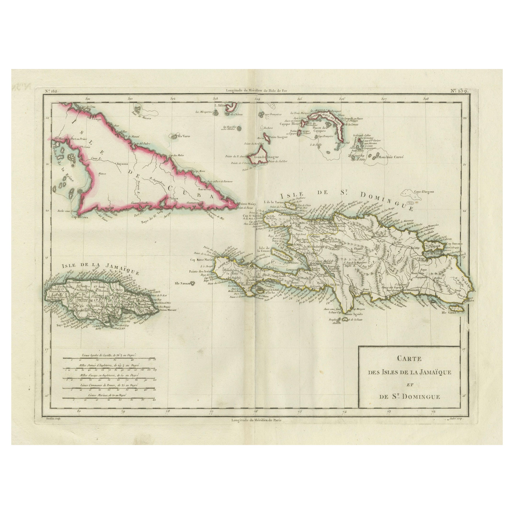
View AllAntique Map of Jamaica and Hispaniola (Saint-Domingue and Santo Domingo), 1802
Located in Langweer, NL
This is an original antique map titled "Carte des Isles de la Jamaïque et de St. Domingue," depicting the islands of Jamaica and Saint-Domingue (modern-day Haiti and the Dominican Re...
Category
Antique Early 1800s Maps
Materials
Paper

$536 Sale Price
20% Off
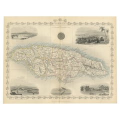
An Ornate and Historical Tallis Map of Jamaica with Decorative Vignettes, 1851
Located in Langweer, NL
This original antique map of Jamaica is part of the renowned series created by the Tallis Company, known for their detailed and decorative maps ...
Category
Antique 1850s Maps
Materials
Paper
$277 Sale Price
20% Off
Original Antique Map of the West Indies by J. Arrowsmith, 1842
Located in Langweer, NL
Title: "J. Arrowsmith's 19th Century Map of the West Indies"
This original antique map, crafted by J. Arrowsmith, details the West Indies with a focus on the Caribbean Sea and its s...
Category
Antique Early 19th Century Maps
Materials
Paper

Antique Map of the West Indies and Central America by W. G. Blackie, 1859
Located in Langweer, NL
Antique map titled 'The West India Island & Central America'. Original antique map of the West Indies and Central America, with inset map of Jamaica. Th...
Category
Antique Mid-19th Century Maps
Materials
Paper

$239 Sale Price
20% Off
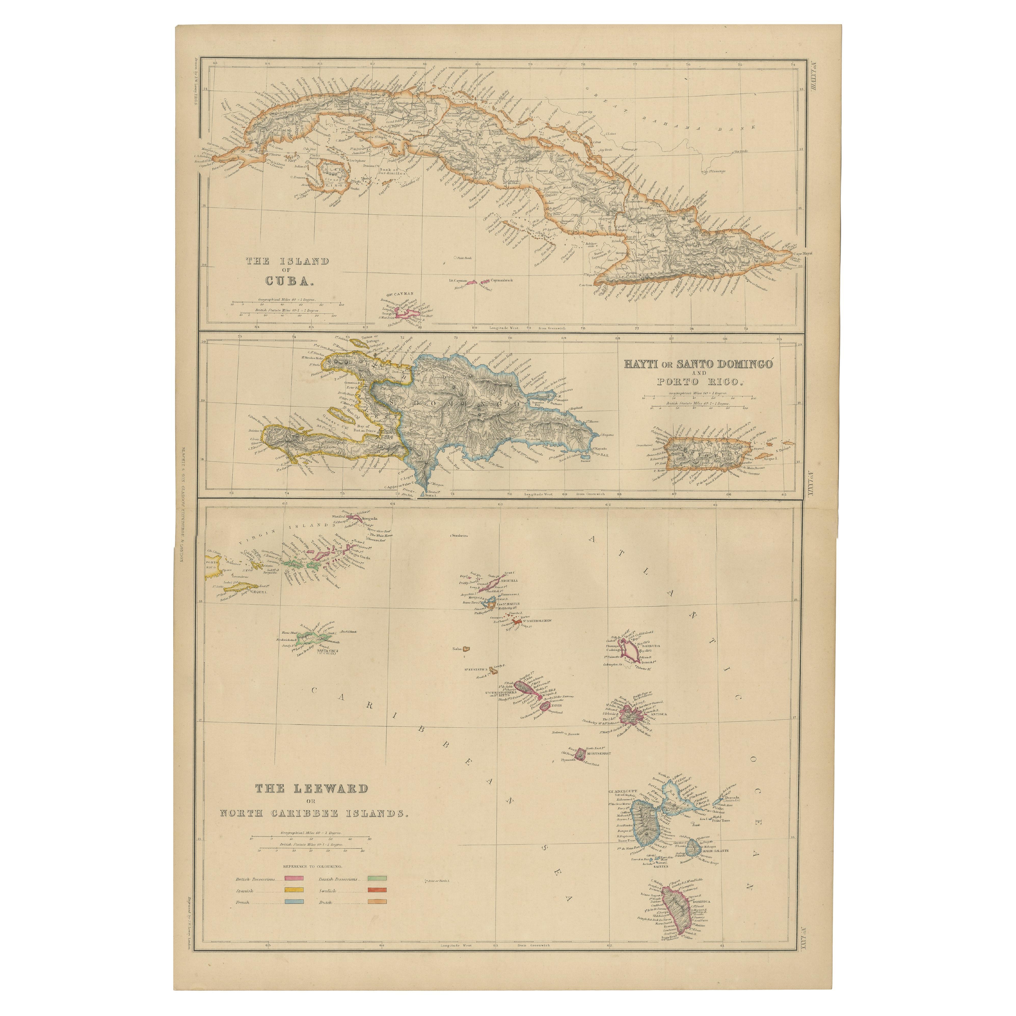
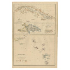
Antique Map of Cuba, Haiti and Porto Rico by W. G. Blackie, 1859
Located in Langweer, NL
Antique map titled 'The Leeward or North Caribbean Islands'. Original antique map of Cuba, Haiti and Porto Rico. This map originates from ‘The Imperial Atla...
Category
Antique Mid-19th Century Maps
Materials
Paper
$239 Sale Price
20% Off
Antique Map of the Antilles in the Caribbean, '1875'
Located in Langweer, NL
Antique map titled 'Carte des Iles Antilles'. Large map of the Antilles. This map originates from 'Atlas de Géographie Moderne Physique et Politique' by A. Levasseur. Published, 1875.
Category
Antique Late 19th Century Maps
Materials
Paper

$359 Sale Price
40% Off
You May Also Like
Large Original Antique Map of The West Indies by Sidney Hall, 1847
Located in St Annes, Lancashire
Great map of The West Indies
Drawn and engraved by Sidney Hall
Steel engraving
Original colour outline
Published by A & C Black. 1847
Unframed
Free shipping.
Category
Antique 1840s Scottish Maps
Materials
Paper

Original Antique Map of Central America / Florida, Arrowsmith, 1820
Located in St Annes, Lancashire
Great map of Central America.
Drawn under the direction of Arrowsmith.
Copper-plate engraving.
Published by Longman, Hurst, Rees, Orme and Brown, 1820
Unframed.
Category
Antique 1820s English Maps
Materials
Paper

Map Colonies Francaises Martinique, 1845
Located in BUNGAY, SUFFOLK
Colonies Francaises, Martinique, Amerique DU SUD
Geographie et Statistique par V.Levasseur. Ing'r Geographe.
Illustre par Raymond Bonheur, peintre.
Grave par Laguihermie, Rue St...
Category
Antique 19th Century French Maps
Materials
Paper

St. Christophe 'St. Kitts' Island: An 18th Century Hand-colored Map by Bellin
By Jacques-Nicolas Bellin
Located in Alamo, CA
Jacques Bellin's copper-plate map of the Caribbean island of Saint Kitts entitled "Carte De De l'Isle St. Christophe Pour servir á l'Histoire Genle. des V...
Category
Antique Mid-18th Century French Maps
Materials
Paper

Early 19th Century Hand Colored Map of the United States and Caribbean Islands
Located in Hamilton, Ontario
Hand coloured early 19th century map by Giraldon of France titled "Etats Unis et Grandes Antilles" (United States and Greater Antilles).
Category
Antique Early 19th Century French Maps
Materials
Paper

$595 Sale Price
40% Off
Original Antique Map of Hungary, Arrowsmith, 1820
Located in St Annes, Lancashire
Great map of Hungary
Drawn under the direction of Arrowsmith.
Copper-plate engraving.
Published by Longman, Hurst, Rees, Orme and Brown, 1820
Unframed.
Category
Antique 1820s English Maps
Materials
Paper

More Ways To Browse
Used Furniture Jamaica
German Colonial
Antique Earthquake
Antique Rum
Antique Rummer
Antique Oushak Carpets
Blue Coffee Tables
1945 Chair Juhl
Antique Three Leg Table
Folke Arstrom
Silver Over Copper
Vintage Barware Glasses
Antique Etched Glass
Antique French Shell
Coffee Table Black Italian Modern
Christofle America
Iranian Silk Rug Carpet
Poul Moller