Items Similar to Detailed Engraving Highlighting Key Regions of Southern Spain and Castile, 1752

Want more images or videos?
Request additional images or videos from the seller
1 of 9
Detailed Engraving Highlighting Key Regions of Southern Spain and Castile, 1752
$633.17
$791.4620% Off
£471.01
£588.7620% Off
€528
€66020% Off
CA$867.02
CA$1,083.7820% Off
A$964.01
A$1,205.0120% Off
CHF 503.35
CHF 629.1920% Off
MX$11,734.35
MX$14,667.9320% Off
NOK 6,422.56
NOK 8,028.2020% Off
SEK 6,017.63
SEK 7,522.0420% Off
DKK 4,019.37
DKK 5,024.2220% Off
Shipping
Retrieving quote...The 1stDibs Promise:
Authenticity Guarantee,
Money-Back Guarantee,
24-Hour Cancellation
About the Item
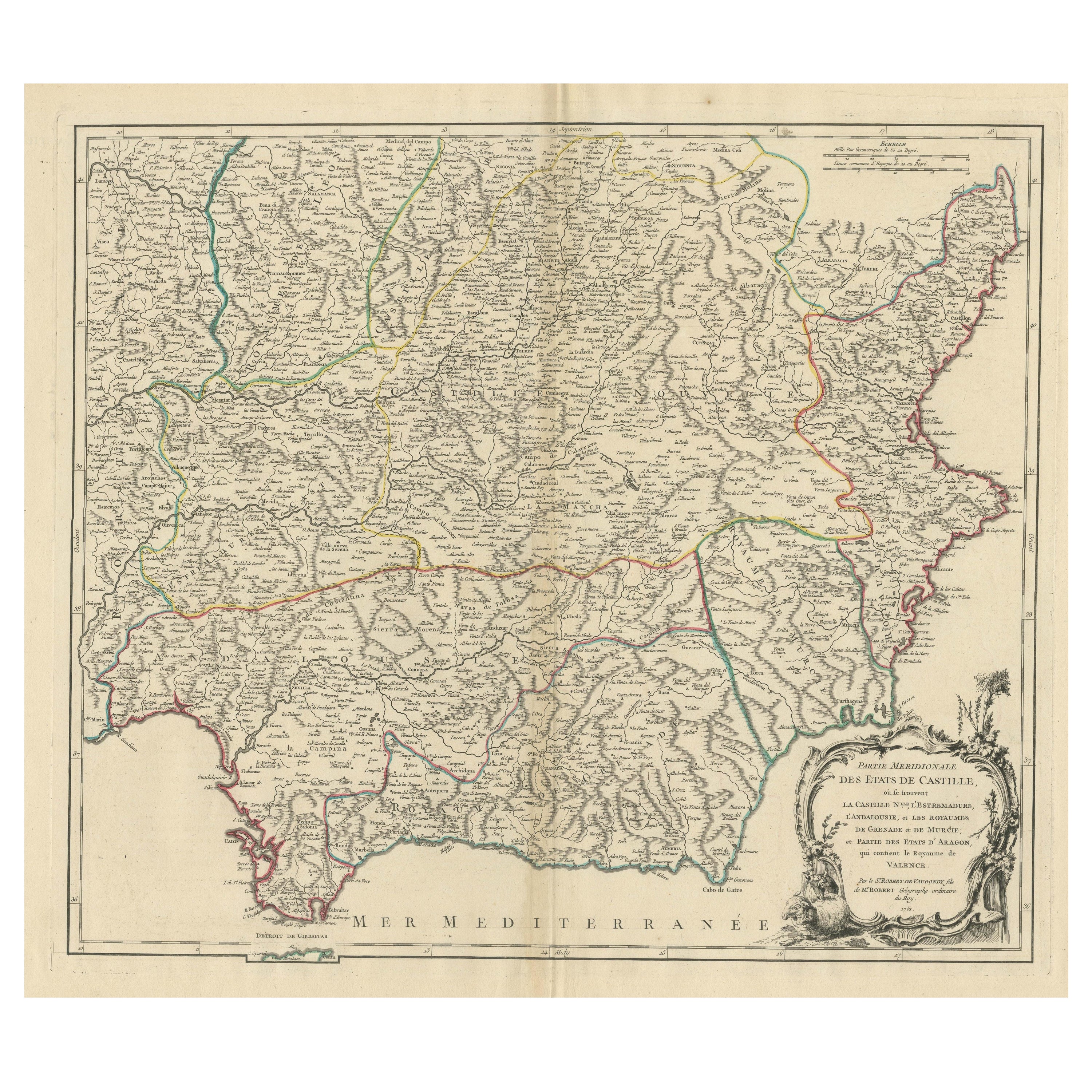
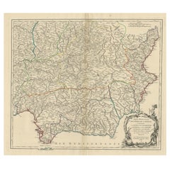
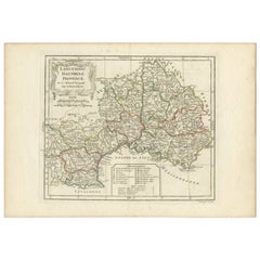
Antique map titled 'Partie Meridionale Des Etats de Castille (..)'. Decorative and highly detailed map of the southern part of Castile, Spain, including a decorative cartouche. Published R. Vaugondy, circa 1760.
Description for a Catalogue:
This beautifully detailed map titled *"Partie Meridionale des Etats de Castille"* was created in 1762 by the renowned French cartographer Robert de Vaugondy, who was appointed geographer to King Louis XV. The map, part of his extensive atlas work, presents an intricate depiction of southern Spain and Castile, including key regions such as *La Castille Vieille*, *Estremadure*, *Andalousie*, the *Kingdoms of Grenade* and *Murcie*, as well as parts of *Aragon* containing the *Kingdom of Valencia*.
The map is adorned with a decorative cartouche that highlights its artistic value, featuring pastoral elements such as a sheep, indicative of the rural nature of the depicted regions.
Important Places Highlighted on the Map:
- **Madrid**: The capital of Spain, centrally located on the map, is marked prominently, reflecting its importance.
- **Granada**: Positioned in the Kingdom of Grenade, Granada is historically significant as the last stronghold of the Moors in Spain.
- **Seville (Sevilla)**: Located in the region of Andalousie, Seville is shown near the Guadalquivir River, emphasizing its role as a major trade center.
- **Valencia**: Found in the Kingdom of Valencia, this coastal city is noted for its historic and economic importance in the Mediterranean.
- **Cadiz**: A vital port city in the southwest, located near the Strait of Gibraltar, Cadiz is highlighted as a key maritime gateway.
- **Gibraltar**: Strategically important, this region is depicted near the southernmost tip of Spain, controlling access between the Mediterranean and the Atlantic.
Notable Features:
- The map is meticulously engraved, displaying mountain ranges, rivers, and cities with high precision.
- The regions are color-coded by hand, a common practice in 18th-century cartography to distinguish different territories.
- The inclusion of decorative elements around the cartouche adds to the aesthetic appeal of the map, making it not just a geographical tool but also a work of art.
This map is a valuable historical document for collectors and those interested in the cartographic history of Spain, offering insight into the political and geographical landscape of the Iberian Peninsula during the 18th century.
Gilles Robert de Vaugondy (1688-1766) and his son Didier Robert de Vaugondy (1723-1786) were leading cartographers in France during the 18th century. They served both as geographer to the king of France. The father, Gilles is also known as ‘Le Sieur’ or ‘Monsieur Robert’. He descended from the Nicolas Sanson family through Sanson's grandson Pierre Moulard-Sanson, from whom he inherited Sanson's cartographic material. After Hubert Jaillot died in 1712, the Vaugondy's acquired numerous copies of his maps and plates, which formed the basis of their beautiful Atlas Universel (1757).
- Dimensions:Height: 20.16 in (51.2 cm)Width: 27.49 in (69.8 cm)Depth: 0.02 in (0.5 mm)
- Materials and Techniques:
- Period:
- Date of Manufacture:1752
- Condition:General age-related toning. Original/contemporary hand coloring. Minor wear, original folding line. Blank verso. Please study image carefully.
- Seller Location:Langweer, NL
- Reference Number:Seller: BG-13431-31stDibs: LU3054339029652
About the Seller
5.0
Recognized Seller
These prestigious sellers are industry leaders and represent the highest echelon for item quality and design.
Platinum Seller
Premium sellers with a 4.7+ rating and 24-hour response times
Established in 2009
1stDibs seller since 2017
2,510 sales on 1stDibs
Typical response time: <1 hour
- ShippingRetrieving quote...Shipping from: Langweer, Netherlands
- Return Policy
Authenticity Guarantee
In the unlikely event there’s an issue with an item’s authenticity, contact us within 1 year for a full refund. DetailsMoney-Back Guarantee
If your item is not as described, is damaged in transit, or does not arrive, contact us within 7 days for a full refund. Details24-Hour Cancellation
You have a 24-hour grace period in which to reconsider your purchase, with no questions asked.Vetted Professional Sellers
Our world-class sellers must adhere to strict standards for service and quality, maintaining the integrity of our listings.Price-Match Guarantee
If you find that a seller listed the same item for a lower price elsewhere, we’ll match it.Trusted Global Delivery
Our best-in-class carrier network provides specialized shipping options worldwide, including custom delivery.More From This Seller
View AllMap of Southern Spain Depicting Castile, Andalusia, Granada, Murcia and Valencia
Located in Langweer, NL
Antique map titled 'Partie Meridionale Des Etats de Castille (..)'. Decorative and highly detailed map of the southern part of Castile, Spain, including a decorative cartouche. Publi...
Category
Antique Mid-18th Century Maps
Materials
Paper
$633 Sale Price
20% Off
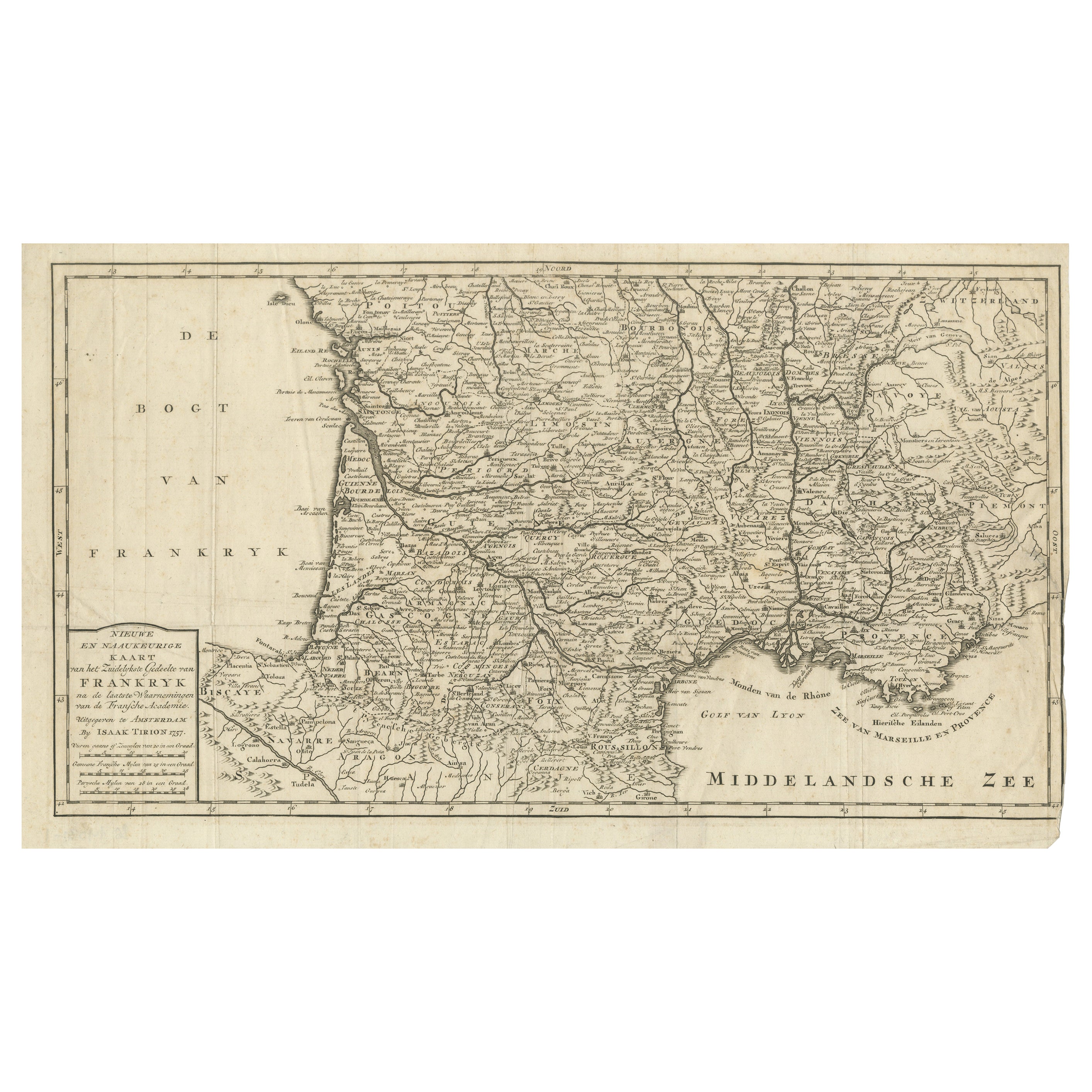
France Map 1757 – Southern Provinces by Isaak Tirion in Dutch Engraving
Located in Langweer, NL
France Map 1757 – Southern Provinces by Isaak Tirion in Dutch Engraving
This original copperplate engraving published in 1757 by Isaak Tirion in Amsterdam presents a highly detailed...
Category
Antique Mid-18th Century Dutch Maps
Materials
Paper
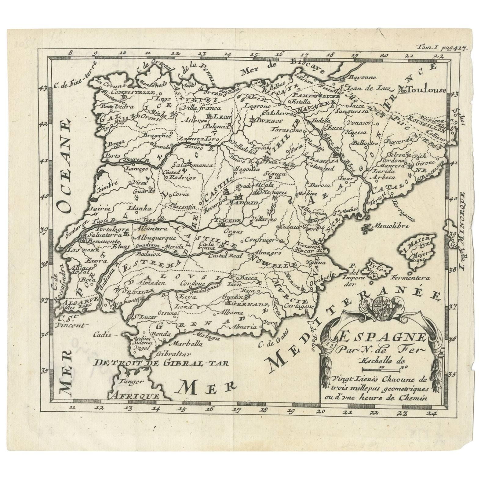
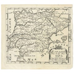
Antique Map of Spain by N. de Fer, circa 1700
Located in Langweer, NL
Antique map of Spain and Portugal with a title cartouche. Nicolas de Fer was the youngest son of the Paris printer and publisher Antoine de Fer. At the ...
Category
Antique Early 18th Century Maps
Materials
Paper
$153 Sale Price
20% Off
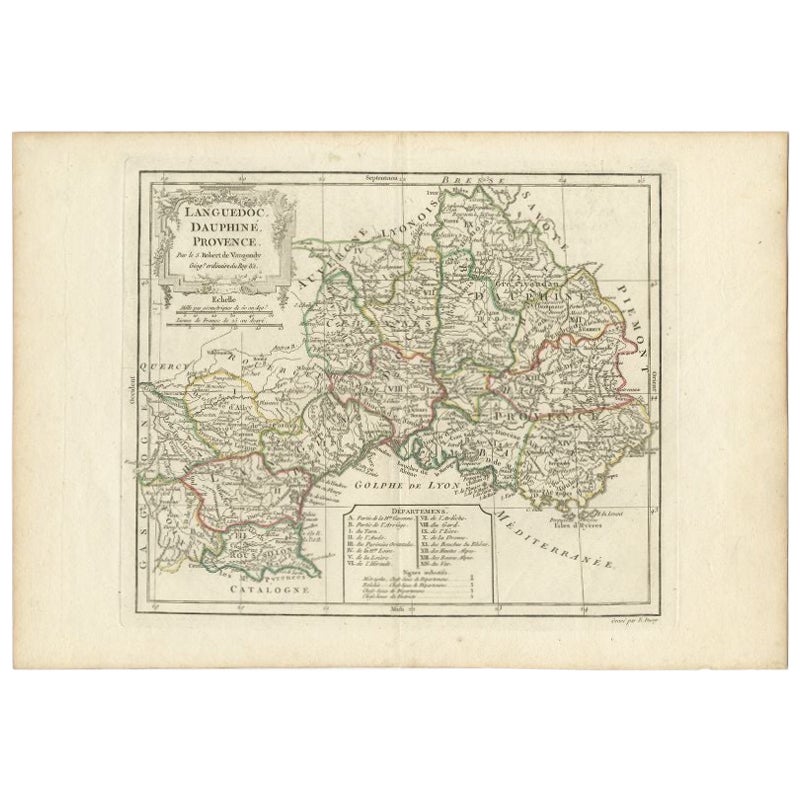
Antique Map of Southeastern France by Vaugondy, c.1790
Located in Langweer, NL
"Antique map titled 'Languedoc, Dauphiné, Province'. Beautiful antique map of Southeastern France with decorative cartouche. Map includes topographical detail as well as a reference ...
Category
Antique 18th Century Maps
Materials
Paper
$153 Sale Price
20% Off
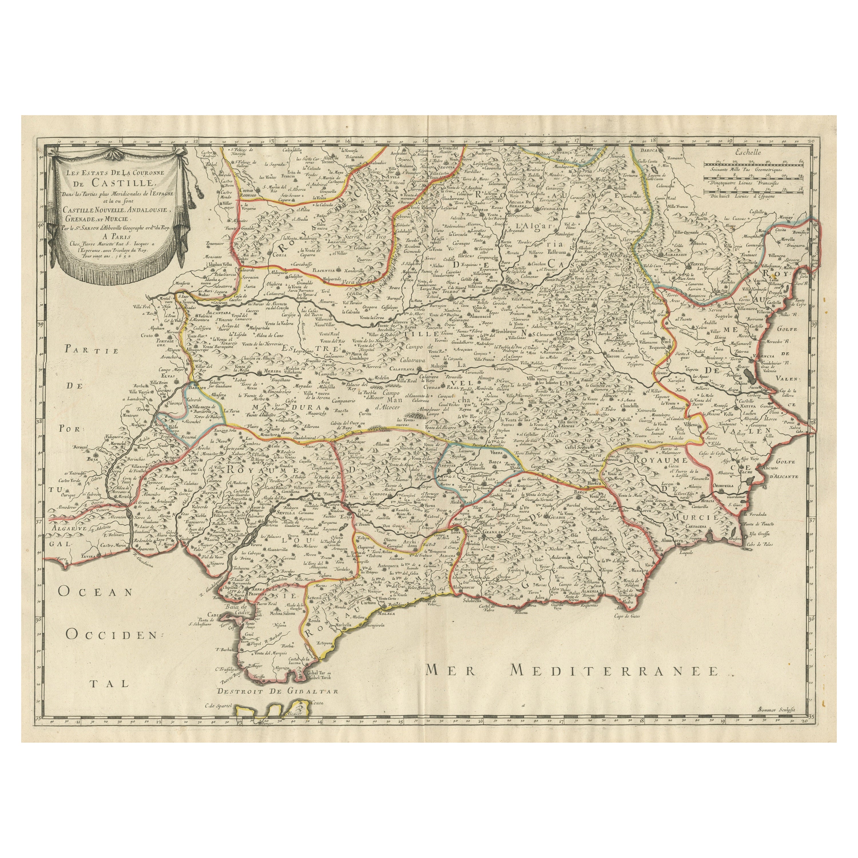
Large Map of Castile's Southern Realms - Granada, Andalusia, and Murcia, 1652
Located in Langweer, NL
This antique map, titled 'Les Etats de la Couronne de Castille', represents the southern regions of the Crown of Castile, specifically the territories of Andalusia, Granada, and Murc...
Category
Antique Mid-17th Century Maps
Materials
Paper

$460 Sale Price
20% Off
Antique Map of Spain and Portugal by Tardieu, circa 1795
Located in Langweer, NL
The image is an antique map titled "Hispanie Betique et Lusitanie", which depicts the Iberian Peninsula during the Roman times, highlighting the provinces of Hispania Baetica (Betiqu...
Category
Antique Late 18th Century Maps
Materials
Paper

$239 Sale Price
20% Off
You May Also Like
1751 Map of Spain Castilla Robert De Vaugondy 1st Edition, Ric.a001
Located in Norton, MA
Large Spain Castilla Robert De Vaugondy
1751 1st Edition
-Colored- Ric.a001
Coming from a family of cartographers, a descendant of the famous Nicolas Sanson and ordinary geographer of the king, Gilles Robert de Vaugondy makes himself known by his maps of the French provinces.
He published an Essay on the History of Geography (1755) from which he excluded the physical geography "too systematic". After a Small Atlas (1748), he draws a universal Atlas (1758), a portable Atlas (1762).
His Atlas of the revolutions of the globe remains unpublished. His warnings and prefaces, his book reviews reveal a Cartesian mind and solid knowledge.
Very early, he associates with his works his son Didier who publishes, since 1742, the methodical tables of Nicolas Sanson, two Globes, one terrestrial, the other celestial (1752).
He is credited with a map of Poland...
Category
Antique 18th Century Unknown Maps
Materials
Paper

Original Antique Map of Spain and Portugal, circa 1790
Located in St Annes, Lancashire
Super map of Spain and Portugal
Copper plate engraving by A. Bell
Published, circa 1790.
Unframed.
Category
Antique 1790s English Other Maps
Materials
Paper

Map of Spain and Portugal - Etching by Pierre François Tardieu - 1837
Located in Roma, IT
Map of Spain and Portugal is an Etching realized by Pierre François Tardieu in 1837.
Good conditions.
The artwork is realized in a well-balanced composition. the artwork and belong...
Category
1830s Modern Figurative Prints
Materials
Lithograph

18th Century Hand Colored Map of Spain and Portugal by Visscher
By Nicolaes Visscher II
Located in Alamo, CA
This is an early 18th century map of Spain and Portugal, with attractive original hand-coloring, entitled "Hispaniae et Portugalliae Regna per Nicolaum Visscher cum Privilegio Ordinu...
Category
Antique Early 18th Century Dutch Maps
Materials
Paper

Li Governi di Borgogna - Ancient Map - 1777
Located in Roma, IT
Li Governi di Borgogna is an original black and white etching on paper, printed by Antonio Zatta in Venice, 1777.
Original Title: Li Governi di Borgogna della Franca Contea e del Ly...
Category
1770s Modern Landscape Prints
Materials
Etching

1771 Bonne Map of Poitou, Touraine and Anjou, France, Ric.a015
Located in Norton, MA
1771 Bonne Map of Poitou,
Touraine and Anjou, France
Ric.a015
1771 Bonne map of Potiou, Touraine and Anjou entitled "Carte des Gouvernements D'Anjou et du Saumurois, de la Touraine, du Poitou,du Pays d'aunis, Saintonge?Angoumois,"
Carte des gouvernements d'Anjou et du Saumurois, de la Touraine, du Poitou, du Pays d'Aunis, Saintonge-Angoumois. Projettee et assujettie au ciel par M. Bonne, Hyd. du Roi. A Paris, Chez Lattre, rue St. Jacques a la Ville de Bord(ea)ux. Avec priv. du Roi. 1771. Arrivet inv. & sculp., Atlas moderne ou collection de cartes sur toutes...
Category
Antique 17th Century Unknown Maps
Materials
Paper

More Ways To Browse
Engraving Tool
Antique Engraving Tools
18th Century Art Tools
Hand Grenade
Sheep Plate
Antique Grenade
20th Century Spanish Table
Antonio Bellini
Antique Oushak Carpets
Blue Coffee Tables
German Bauhaus Posters
1945 Chair Juhl
Antique Three Leg Table
Folke Arstrom
Silver Over Copper
Vintage Barware Glasses
Antique Etched Glass
Antique French Shell