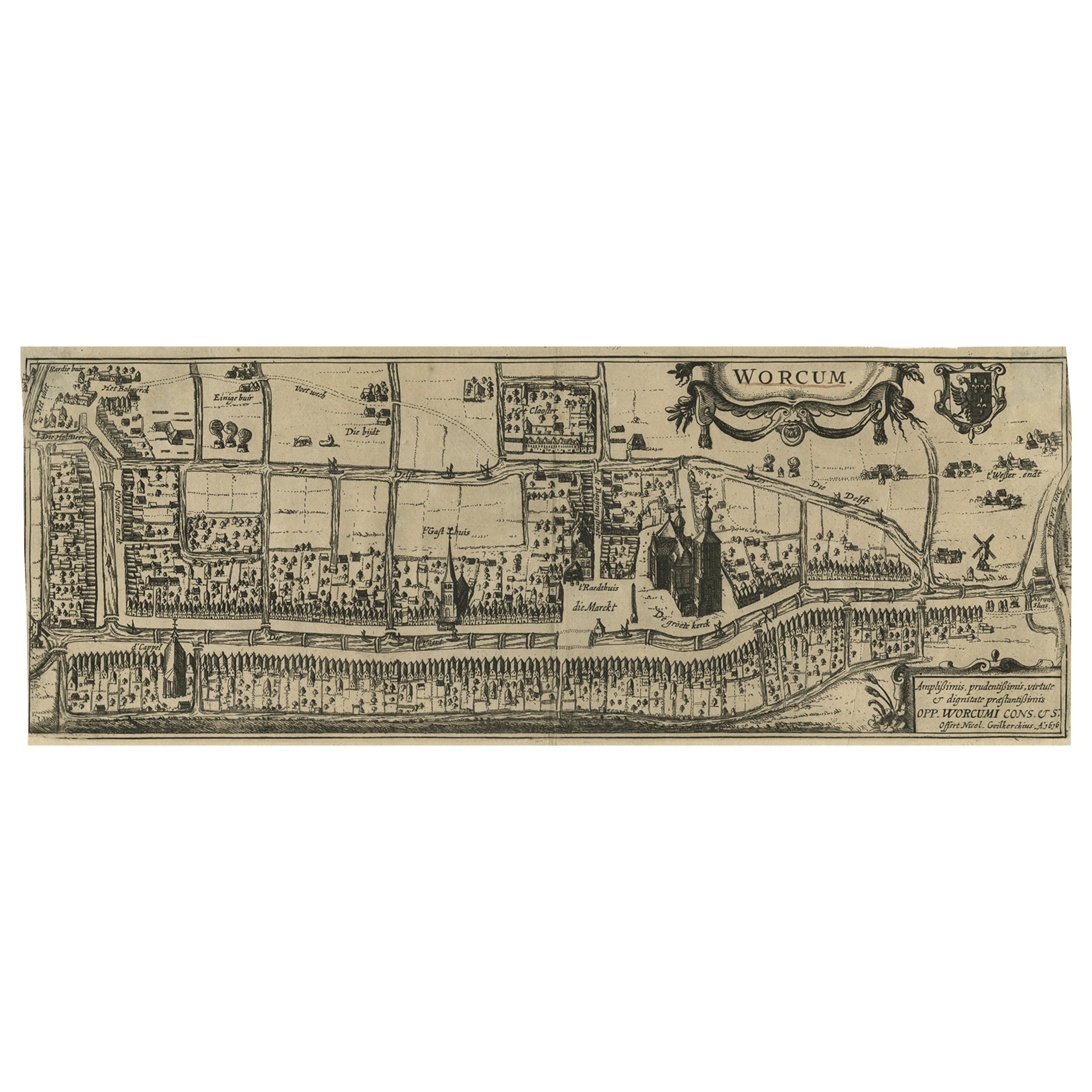
Items Similar to Dutch City Plan of Workum in Friesland by N. Van Geelkercken, hand-colored 1616

Want more images or videos?
Request additional images or videos from the seller
1 of 10
Dutch City Plan of Workum in Friesland by N. Van Geelkercken, hand-colored 1616
$730.75
£550.40
€620
CA$1,007.73
A$1,132.14
CHF 591.54
MX$13,818.29
NOK 7,510.89
SEK 7,069.92
DKK 4,719.20
About the Item
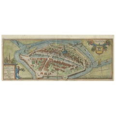
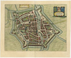
Workum in Friesland by Nicolaes van Geelkercken, hand-colored map ca. 1616
This beautifully hand-colored engraving titled 'Worcum' presents an early 17th-century bird’s-eye view of the historic Frisian city of Workum, located in the northern Netherlands.
It was published in 1616 as part of Rerum Frisicarum Historia by Ubbo Emmius, a foundational work chronicling the history and geography of Friesland. The cartographer, Nicolaes van Geelkercken (1585–1656), was a Dutch mapmaker and land surveyor known for his precise and decorative cartographic works, often commissioned for historical and municipal publications.
Rendered in vibrant hand-applied colors, the map vividly illustrates the walled layout of Workum with detailed depictions of buildings, waterways, gardens, windmills, churches, and town defenses. Notable landmarks include the 'Groote Kerk' (the large church), prominently positioned in the center-right with three domed towers, and the 'Raadhuis' (town hall), shown on the town’s market square. The canals—such as 'Die Delft', 'Het Vliet', and 'Noorder Eijnd'—are shown with boats, emphasizing the city's integration with inland waterways for transport and trade.
This plan is oriented with the west at the top and is adorned with a decorative cartouche in the upper right featuring the city’s coat of arms—an eagle divided by a cross—and another inscription cartouche in the lower right that dedicates the map to the city council (OPP. WORCUMI CONS. C.S.). The delicate balance between cartographic accuracy and pictorial charm makes it not only a historical document but also a fine example of early modern Dutch map art.
This map is a superb addition for collectors of Dutch city plans, Friesland history, or 17th-century cartography. Its early depiction of urban development in the northern Netherlands offers valuable insight into the architectural and civic landscape of the Dutch Republic during the Golden Age.
Condition report:
Overall good condition. Hand-coloring well-preserved. Minor age toning and small edge tears, mostly confined to margins. Centerfold as issued. Slight creasing at the edges, but image area remains strong and clean.
Framing tips:
Frame in warm walnut or black wood with UV-filtering glass. Use a soft cream or antique white mat to accentuate the vibrant hand coloring. Leave a wide margin to showcase the cartouches and edge details.
- Dimensions:Height: 5.52 in (14 cm)Width: 14.38 in (36.5 cm)Depth: 0.01 in (0.2 mm)
- Materials and Techniques:Paper,Engraved
- Place of Origin:
- Period:1610-1619
- Date of Manufacture:1616
- Condition:Overall good condition. Hand-coloring well-preserved. Minor age toning and small edge tears, mostly confined to margins. Centerfold as issued. Slight creasing at the edges, but image area remains strong and clean. Study the images carefully.
- Seller Location:Langweer, NL
- Reference Number:Seller: BG-12991-11stDibs: LU3054345130122
About the Seller
5.0
Recognized Seller
These prestigious sellers are industry leaders and represent the highest echelon for item quality and design.
Platinum Seller
Premium sellers with a 4.7+ rating and 24-hour response times
Established in 2009
1stDibs seller since 2017
2,534 sales on 1stDibs
Typical response time: <1 hour
- ShippingRetrieving quote...Shipping from: Langweer, Netherlands
- Return Policy
Authenticity Guarantee
In the unlikely event there’s an issue with an item’s authenticity, contact us within 1 year for a full refund. DetailsMoney-Back Guarantee
If your item is not as described, is damaged in transit, or does not arrive, contact us within 7 days for a full refund. Details24-Hour Cancellation
You have a 24-hour grace period in which to reconsider your purchase, with no questions asked.Vetted Professional Sellers
Our world-class sellers must adhere to strict standards for service and quality, maintaining the integrity of our listings.Price-Match Guarantee
If you find that a seller listed the same item for a lower price elsewhere, we’ll match it.Trusted Global Delivery
Our best-in-class carrier network provides specialized shipping options worldwide, including custom delivery.More From This Seller
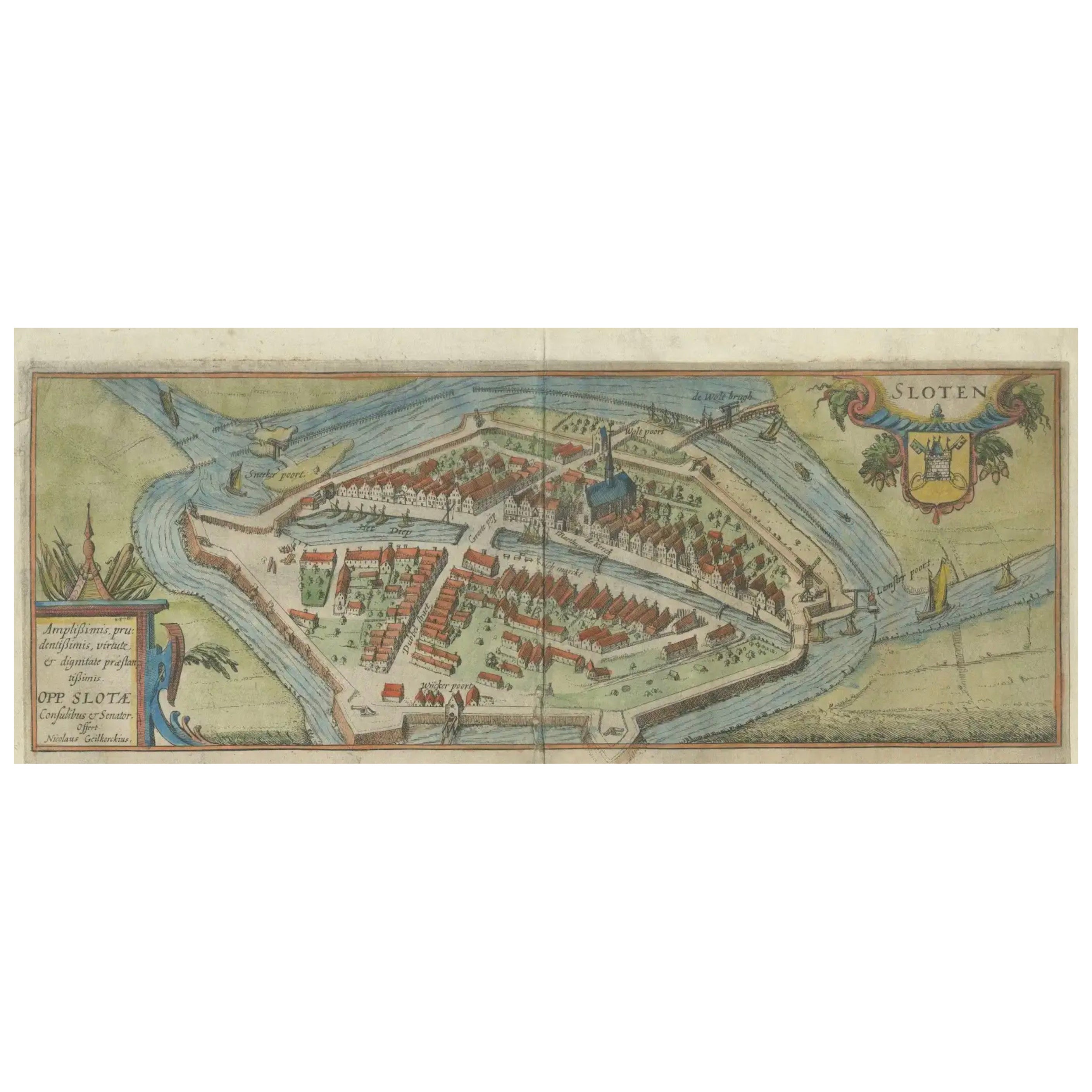
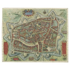
View AllDutch City Plan of Sloten in Friesland by N. Van Geelkercken, hand-colored 1616
Located in Langweer, NL
Bird’s-Eye View of Sloten in Friesland by Nicolaes van Geelkercken, ca. 1616
This captivating hand-colored engraving presents an early 17th-century bird’s-eye view of the fortified ...
Category
Antique 1610s Dutch Maps
Materials
Paper
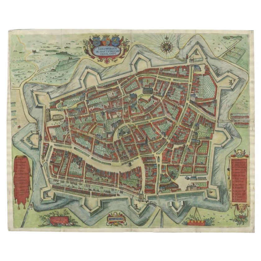
Handcolored Rare Map of Leeuwarden, Capital of Friesland, The Netherlands, 1622
Located in Langweer, NL
Antique map titled 'Leeuwerden de Hooftstadt van Vrieslandt'. Rare and old map of the city of Leeuwarden, Friesland.
Artists and Engravers: Published by Pieter Feddes van Harlingen...
Category
Antique 17th Century Maps
Materials
Paper
Original Old & Rare View of the City of Workum, Friesland, The Netherlands, 1616
Located in Langweer, NL
Antique map titled 'Worcum'. This print depicts the city of Workum (Friesland, The Netherlands). With German captions. This print originates from 'Rerum Frisicarum Historia' publishe...
Category
Antique 1610s Maps
Materials
Paper

$396 Sale Price
20% Off
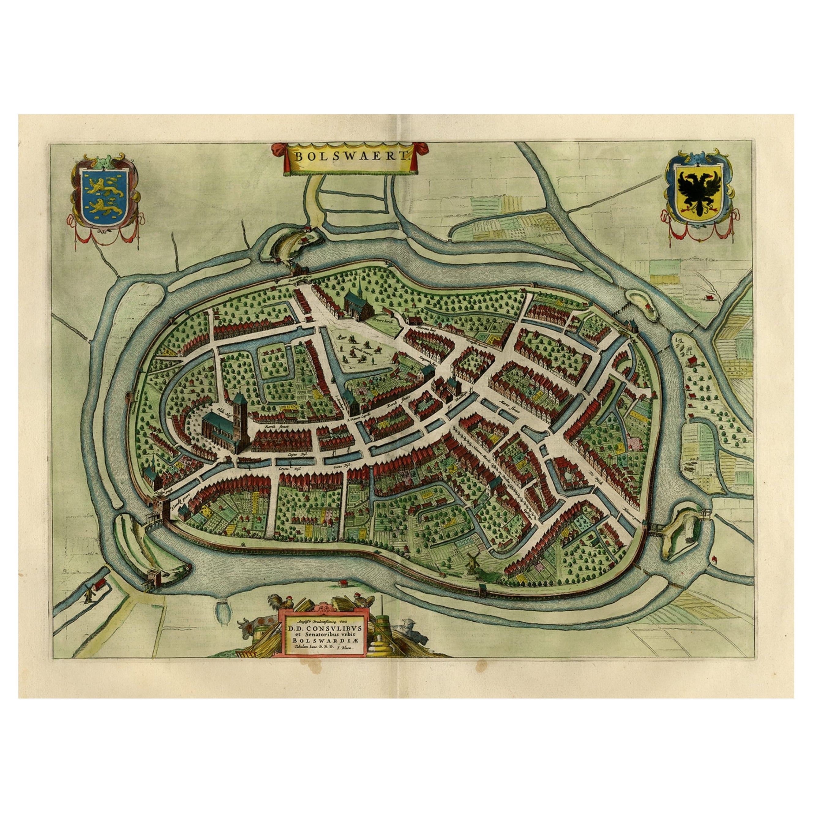
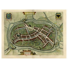
Nice Hand-Colored Plan by Blaeu of Bolsward in Friesland, the Netherlands, 1652
Located in Langweer, NL
Antique print, titled: 'Bolswaert' - (Town plan of Bolsward).
Plan of Bolsward in Friesland, the Netherlands. A cartouche and two coats of arms. From the town atlas 'Toneel der S...
Category
Antique 1650s Maps
Materials
Paper
$1,084 Sale Price
20% Off
Antique Map of the City of Dokkum, Friesland by Blaeu, c.1650
Located in Langweer, NL
Antique map titled ?Dockum?. Plan of Dokkum in Friesland, the Netherlands. A cartouche with two coats of arms. Originates from the town atlas 'Toneel der Steden', published by Joan Blaeu...
Category
Antique 17th Century Maps
Materials
Paper
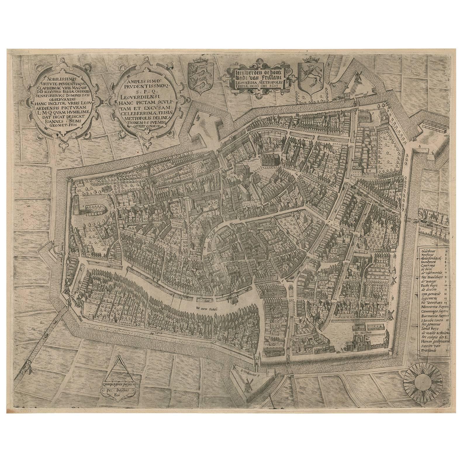
Rare Antique Map of Leeuwarden, Friesland, The Netherlands, by P. Bast, 1603
By P. Bast
Located in Langweer, NL
Very rare plan of Leeuwarden, Friesland, The Netherlands. With several cartouches and coat of arms. With a legend and compass rose at bottom right. Made by 'Pieter Bast' after the su...
Category
Antique Early 17th Century Maps
Materials
Paper

$3,447 Sale Price
35% Off
You May Also Like
Map of Kampen, Netherlands - by G. Braun and F. Hogenberg - Late 16th Century
By Franz Hogenberg
Located in Roma, IT
This map of Kampen (the ancient Campensis) is an original etching realized by George Braun and Franz Hogenberg as part of the famous Series "Civitates Orbis Terrarum".
The “Civita...
Category
16th Century Figurative Prints
Materials
Etching

Map of the Netherlands - Etching by G. Braun and F. Hogenberg -Late 16th Century
By Franz Hogenberg
Located in Roma, IT
Map of the Netherlands is an original etching realized by George Braun and Franz Hogenberg, as part of the "Civitates Orbis Terrarum".
The “Civitates Orbis Terrarum” (Atlas of Citi...
Category
16th Century Figurative Prints
Materials
Etching

View of Emden, Germany: A 16th Century Hand-colored Map by Braun & Hogenberg
By Franz Hogenberg
Located in Alamo, CA
This is a 16th century original hand-colored copperplate engraved map of a bird's-eye View of Embden, Germany entitled " Emuda, vulgo Embden vrbs Frisia orientalis primaria" by Georg Braun & Franz Hogenberg, in volume II of their famous city atlas "Civitates Orbis Terrarum", published in Cologne, Germany in 1575.
This is a beautifully colored and detailed map of Emden, a seaport in northwestern Germany, along the Ems River and perhaps portions of over Dollart Bay, near the border with the Netherland. The map depicts a bird's-eye view of the city from the southwest, as well as a view of the harbor and an extensive system of canals. Numerous ships of various sizes, as well as two rowboats containing numerous occupants are seen in the main waterway in the foreground and additional boats line two canals in the center of the city. Two men and two women are shown on a hill in the foreground on the right, dressed in the 16th century style of nobility. Two ornate crests are included in each corner. A title strap-work cartouche is in the upper center with the title in Latin. The crest on the right including Engelke up de Muer (The Little Angel on the Wall) was granted by Emperor Maximilian I in 1495.
This is an English translation of an excerpt of Braun's description of Embden: "In Emden, the capital of East Frisia, rich merchants live in very fine houses. The city has a broad and well-situated harbour, which in my opinion is unique in Holland. Frisia and the whole of the Netherlands, for the ships can anchor here right under the city walls. They have also extended the harbour as far as the New Town, so that up to 400 ships can now find shelter here when the sea is rough."
The emphasis on the harbor and waterways within the city highlights the importance of Emden's place as a seaport at this time. Embden developed from a Dutch/Flemish trading settlement in the 7th-8th centuries into a city as late as late 14th century. In 1494 it was granted staple rights, and in 1536 the harbour was extended. In the mid-16th century Emden's port was thought to have the most ships in Europe. Its population then was about 5,000, rising to 15,000 by the end of the 16th century. The Ems River flowed directly under the city walls, but its course was changed in the 17th century by the construction of a canal. Emden has canals within its city limits, a typical feature of Dutch towns, which also enabled the extension of the harbor. In 1744 Emden was annexed by Prussia and is now part of Germany. It was captured by French forces in 1757 during the Seven Years' War, but recaptured by Anglo-German forces in 1758. During the Napoleonic French era, Emden and the surrounding lands of East Frisia were part of the short-lived Kingdom of Holland.
References:Van der Krogt 4, 1230, State 2; Taschen, Braun and Hogenberg...
Category
16th Century Old Masters Landscape Prints
Materials
Engraving

Tournai (Tournay), Belgium: A 16th Century Hand-colored Map by Braun & Hogenberg
By Franz Hogenberg
Located in Alamo, CA
This is a 16th century original hand-colored copperplate engraved map of Tournai, Belgium, entitled "Tornacum" by Georg Braun & Franz Hogenberg, in volume IV of their famous city atlas "Civitates Orbis Terrarum", published in Cologne or Augsberg, Germany in 1575. The map provides a bird's-eye view of the walled city of Tournai, the second oldest city in Belgium. It lies approximately one hour by car southwest of Brussels or from Ghent. The names of thirty of its streets, prominent buildings, churches and squares are listed in a key within a strap-work cartouche in the lower left. These locations are numbered in the key corresponding to their locations on the map.
This colorful map of Tournai (Tornacum or Tournay as it was called in the 16th century) includes the title in Latin in a cartouche in the upper center. Three crests are present across the upper map. A man and two woman are standing on a hill in the foreground in the lower right dressed in the style of 16th century upper class residents of the town.
This is an English translation of an excerpt of Braun's description of Tornai: “Tornacum or Turnacum is a city in Gallia Belgica, situated on the Schelde in the territory of the Nervii, called Tournai by its French inhabitants, but Dorneck by the Germans. Tournai has always been a large and powerful city, with an abundance of goods and commercial activities and wonderfully resourceful craftsmen, who invent new articles every day, and although some of these go out of use they constantly conceive of other new things, both useful and delightful, so that they have at all times something that provides work and a means of livelihood for the poor."
ReferencesVan der Krogt 4, 4435, State 1; Taschen, Braun and Hogenberg...
Category
16th Century Old Masters Landscape Prints
Materials
Engraving

Map of Nijmegen - Etching by G. Braun and F. Hogenberg - Late 16th Century
By Franz Hogenberg
Located in Roma, IT
This map of Noviomagvs is an original etching realized by Georg Braun and Franz Hogenberg as part of the famous series "Civitates Orbis Terrarum".
The state of preservation of the ...
Category
16th Century Figurative Prints
Materials
Etching

Utrecht, Antique Map from "Civitates Orbis Terrarum"
By Franz Hogenberg
Located in Roma, IT
Braun G., Hogenberg F., Traiectum or Utrecht, from the collection Civitates Orbis Terrarum, Cologne, T. Graminaeus, 1572-1617.
Very fine B/W aquatint showing a view of Utrecht, with...
Category
16th Century Landscape Prints
Materials
Etching

More Ways To Browse
Antique Architectural Plans
Dutch Engraved Glass
Large Wall Maps
Dutch Windmill
Van Delft
Dior Coat S
Antique Surveyor
17th Century Dutch Wood Frames
Delft 17th C
Delft Windmill
Solid Mahogany Table
Dessert Glasses
Geometric Glass Table
Mid Century Pin
6x10 Rug
Studded Furniture
Styles Of Antique Desks
Black And White Coffee Table