Items Similar to Handcolored Rare Map of Leeuwarden, Capital of Friesland, The Netherlands, 1622
Want more images or videos?
Request additional images or videos from the seller
1 of 5
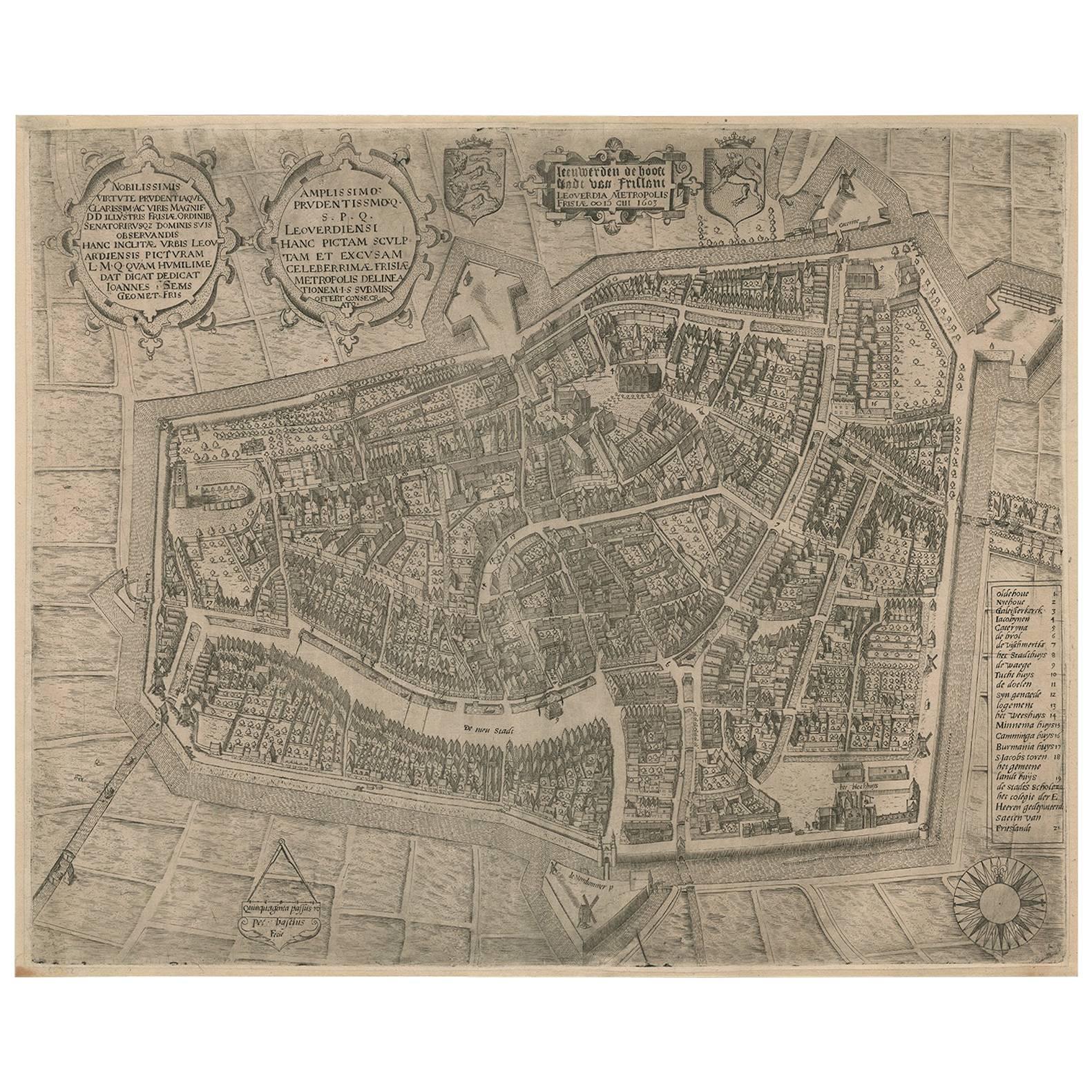
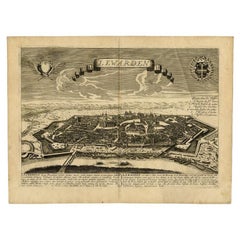
Handcolored Rare Map of Leeuwarden, Capital of Friesland, The Netherlands, 1622
About the Item
Antique map titled 'Leeuwerden de Hooftstadt van Vrieslandt'. Rare and old map of the city of Leeuwarden, Friesland.
Artists and Engravers: Published by Pieter Feddes van Harlingen (1586–1623), a Dutch Golden Age painter.
Condition: Good, professionally restored with later hand coloring. Please study image carefully.
Date: 1622
Overall size: 50 x 41 cm.
Image size: 52.5 x 43 cm.
We sell original antique maps to collectors, historians, educators and interior decorators all over the world. Our collection includes a wide range of authentic antique maps from the 16th to the 20th centuries. Buying and collecting antique maps is a tradition that goes back hundreds of years. Antique maps have proved a richly rewarding investment over the past decade, thanks to a growing appreciation of their unique historical appeal. Today the decorative qualities of antique maps are widely recognized by interior designers who appreciate their beauty and design flexibility. Depending on the individual map, presentation, and context, a rare or antique map can be modern, traditional, abstract, figurative, serious or whimsical. We offer a wide range of authentic antique maps for any budget.
- Dimensions:Height: 16.15 in (41 cm)Width: 19.69 in (50 cm)Depth: 0 in (0.01 mm)
- Materials and Techniques:
- Period:
- Date of Manufacture:1622
- Condition:Condition: Good, professionally restored with later hand coloring. Please study image carefully.
- Seller Location:Langweer, NL
- Reference Number:
About the Seller
5.0
Platinum Seller
These expertly vetted sellers are 1stDibs' most experienced sellers and are rated highest by our customers.
Established in 2009
1stDibs seller since 2017
1,933 sales on 1stDibs
Typical response time: <1 hour
- ShippingRetrieving quote...Ships From: Langweer, Netherlands
- Return PolicyA return for this item may be initiated within 14 days of delivery.
More From This SellerView All
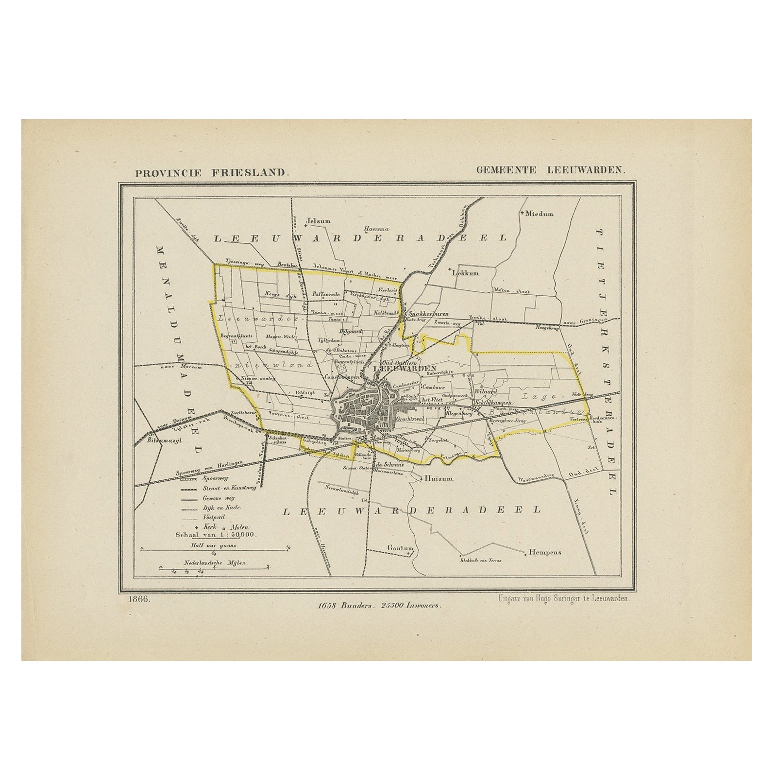
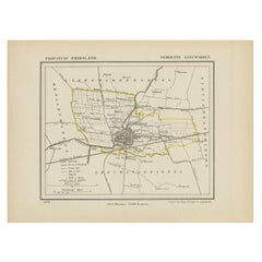
- Antique Map of Leeuwarden, Capital of Friesland, the Netherlands, 1868Located in Langweer, NLAntique map titled 'Provincie Friesland - Gemeente Leeuwarden'. Map of the township of Leeuwarden, Friesland. This map originates from 'Gemeente-Atlas van Nederland' by J. Kuyper. Ar...Category
Antique 19th Century Maps
MaterialsPaper
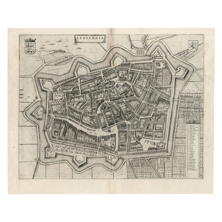
- Antique Map of Leeuwarden, Capital of Friesland, the Netherlands, by Blaeu, 1649Located in Langweer, NLAntique map titled 'Leoverdia.' Bird's-eye view plan of Leeuwarden, Friesland, the Netherlands. With key to locations and coats of arms. Text in Dutch on verso. This plan origina...Category
Antique 17th Century Maps
MaterialsPaper
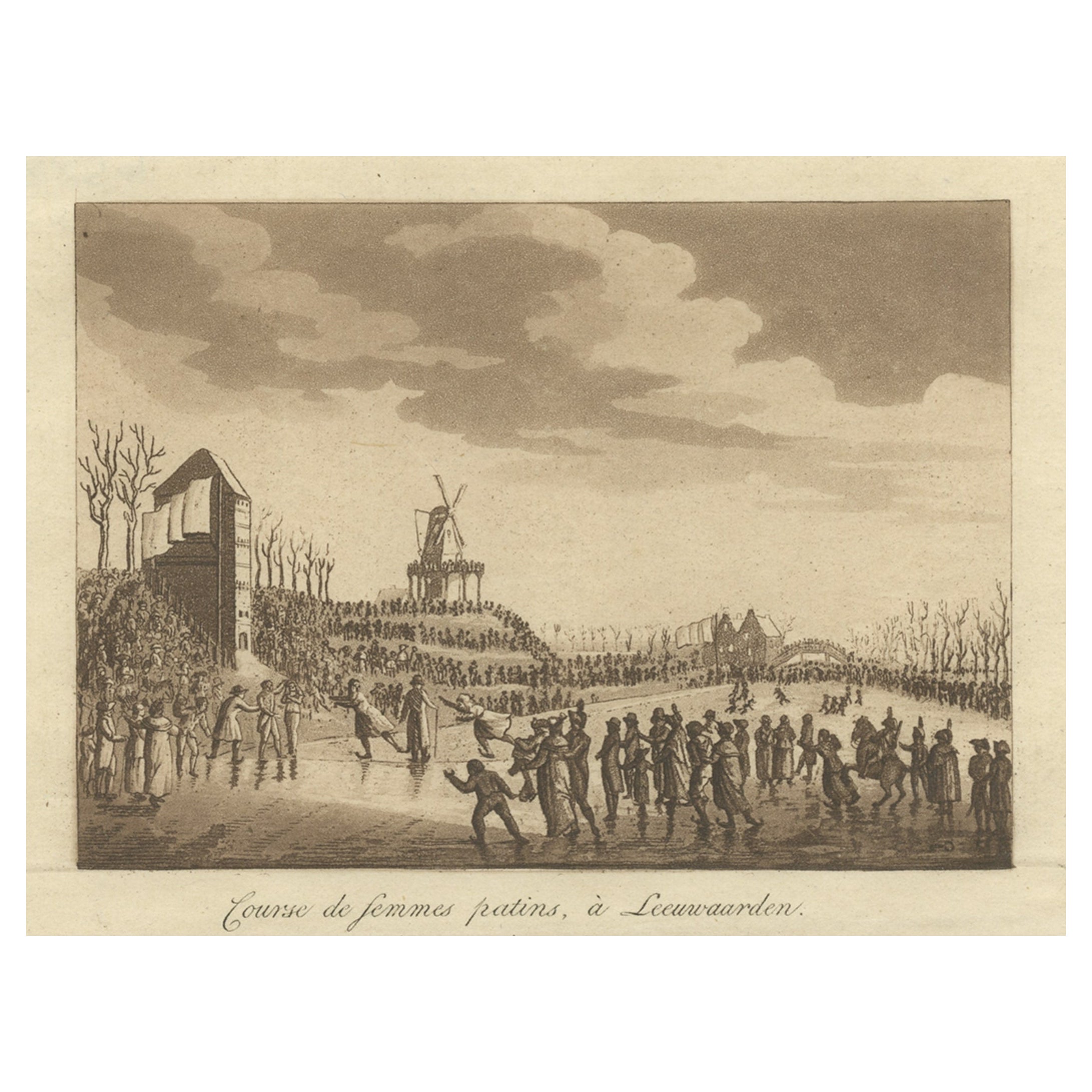
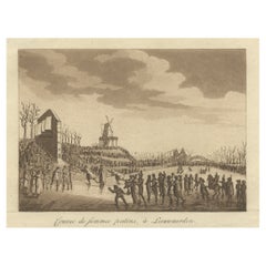
- Rare Print of Ice Skating in Leeuwarden, Capital of Friesland, The NetherlandsLocated in Langweer, NLAntique print titled 'Course de femmes patins, à Leeuwaarden'. Old print depicting a ladies skating competition in Leeuwarden, Friesland. This print originates from 'Merkwaardige gez...Category
Antique 19th Century Prints
MaterialsPaper
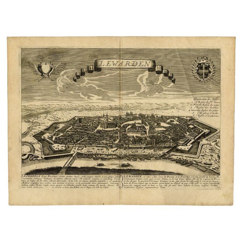
- Antique Print of the Capital of Friesland Leeuwarden, The Netherlands, c.1670Located in Langweer, NLAntique print titled 'Lewarden.' A bird's eye view of Leeuwarden (Friesland, the Netherlands). Views of Jollain are scarse and sought after by collectors. Artists and Engravers: M...Category
Antique 17th Century Prints
MaterialsPaper
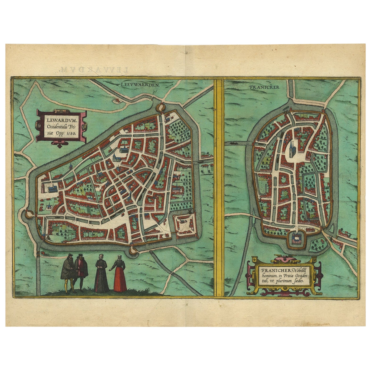
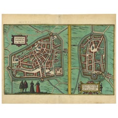
- Antique Map of The Frisian Cities Leeuwarden and Franeker in Friesland, 1580Located in Langweer, NLAntique map titled 'Lewardum Occidentlis Frisiae Opp: 1580, Franicher Nobiliu hominum, in Frisia Occidentali, ut plurimum saedes'. This sheet contains two very detailed bird?s-ey...Category
Antique 16th Century Maps
MaterialsPaper
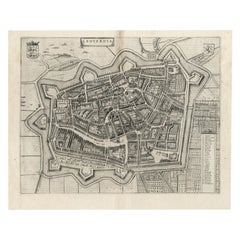
- VeryRare Antique Map of Leeuwarden, Friesland, The Netherlands, by P. Bast, 1603By P. BastLocated in Langweer, NLVery rare plan of Leeuwarden, Friesland, The Netherlands. With several cartouches and coat of arms. With a legend and compass rose at bottom right. Made by 'Pieter Bast' after the su...Category
Antique Early 17th Century Maps
MaterialsPaper

You May Also Like
- Original Antique Map of the American State of Nevada, 1889Located in St Annes, LancashireGreat map of Nevada Drawn and Engraved by W. & A.K. Johnston Published By A & C Black, Edinburgh. Original colour Unframed.Category
Antique 1880s Scottish Victorian Maps
MaterialsPaper
- Original Antique Map of the American State of Oregon, 1889Located in St Annes, LancashireGreat map of Oregon Drawn and Engraved by W. & A.K. Johnston Published By A & C Black, Edinburgh. Original colour Unframed.Category
Antique 1880s Scottish Victorian Maps
MaterialsPaper
- Original Antique Map of the American State of Washington, 1889Located in St Annes, LancashireGreat map of Washington Drawn and Engraved by W. & A.K. Johnston Published By A & C Black, Edinburgh. Original colour Unframed.Category
Antique 1880s Scottish Victorian Maps
MaterialsPaper
- Original Antique Map of the American State of Pennsylvania, 1889Located in St Annes, LancashireGreat map of Pennsylvania Drawn and Engraved by W. & A.K. Johnston Published By A & C Black, Edinburgh. Original colour Unframed. Repair to a minor tear on bottom edge.Category
Antique 1880s Scottish Victorian Maps
MaterialsPaper
- Original Antique Map of The United States of America, circa 1890Located in St Annes, LancashireGreat map of the USA By The Stanford's Geographical Establishment Original colour Unframed.Category
Antique 1890s English Victorian Maps
MaterialsPaper
- Large Original Antique Map of the United States of America. 1891By Rand McNally & Co.Located in St Annes, LancashireFabulous map of The United States Original color By Rand, McNally & Co. Dated 1891 Unframed Free shipping.Category
Antique 1890s American Maps
MaterialsPaper


Recently Viewed
View AllMore Ways To Browse
Capital Of Antique
Antique Capital
Used Furniture Harlingen
Tree Bag
16th Century Scotland
Great Britain Maps
Used Furniture Depot
World Map British
Copper Map Plate
Swiss Antiques And Collectables
Large Antique World Maps
Large Antique World Map
Antique World Map Large
Antique Map Compass
Compass Antique Map
Antique Compass Map
Antique County Maps
Antique Russian Wood Furniture