Items Similar to Antique Map of The Frisian Cities Leeuwarden and Franeker in Friesland, 1580
Want more images or videos?
Request additional images or videos from the seller
1 of 5
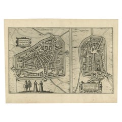
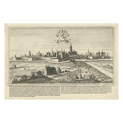
Antique Map of The Frisian Cities Leeuwarden and Franeker in Friesland, 1580
About the Item
Antique map titled 'Lewardum Occidentlis Frisiae Opp: 1580, Franicher Nobiliu hominum, in Frisia Occidentali, ut plurimum saedes'.
This sheet contains two very detailed bird?s-eye plans of moat surrounded cities. The left-hand view depicts Leeuwarden in 1580, with four costumed figures are shown in the foreground. The right-hand view shows Franeker, situated about 20 kilometres west of Leeuwarden. Latin text on verso.
Artists and Engravers: Georg Braun (1541?1622) was a topo-geographer. From 1572 to 1617, he edited the "Civitates orbis terrarum", which contains 546 prospects, bird's-eye views and maps of cities from all around the world. He was the principal editor of the work, he acquired the tables, hired the artists, and wrote the texts. Frans Hogenberg (1535?1590) was a Flemish and German painter, engraver, and mapmaker. Hogenberg was born in Mechelen, the son of Nicolaas Hogenberg. In 1568 he was banned from Antwerp by the Duke of Alva and travelled to London, where he stayed a few years before emigrating to Cologne. He is known for portraits and topographical views as well as historical allegories. He also produced scenes of contemporary historical events.
Artist: Georg Braun (1541?1622) was a topo-geographer. From 1572 to 1617, he edited the "Civitates orbis terrarum", which contains 546 prospects, bird's-eye views and maps of cities from all around the world. He was the principal editor of the work, he acquired the tables, hired the artists, and wrote the texts. Frans Hogenberg (1535?1590) was a Flemish and German painter, engraver, and mapmaker. Hogenberg was born in Mechelen, the son of Nicolaas Hogenberg. In 1568 he was banned from Antwerp by the Duke of Alva and travelled to London, where he stayed a few years before emigrating to Cologne. He is known for portraits and topographical views as well as historical allegories. He also produced scenes of contemporary historical events.
Condition: Very good. Nice hand-coloring. Please study image carefully.
Date: 1580
Overall size: 50 x 39 cm.
Image size: 48.5 x 30.8 cm.
- Dimensions:Height: 19.69 in (50 cm)Width: 15.36 in (39 cm)Depth: 0 in (0.01 mm)
- Materials and Techniques:
- Period:
- Date of Manufacture:1580
- Condition:
- Seller Location:Langweer, NL
- Reference Number:
About the Seller
5.0
Platinum Seller
These expertly vetted sellers are 1stDibs' most experienced sellers and are rated highest by our customers.
Established in 2009
1stDibs seller since 2017
1,948 sales on 1stDibs
Typical response time: <1 hour
- ShippingRetrieving quote...Ships From: Langweer, Netherlands
- Return PolicyA return for this item may be initiated within 14 days of delivery.
More From This SellerView All
- Antique Map of the City of Leeuwarden and Franeker by Braun & Hogenberg, 1580Located in Langweer, NLAntique map titled 'Lewardum Occidentlis Frisiae Opp: 1580, Franicher Nobiliu hominum, in Frisia Occidentali, ut plurimum saedes'. This sheet contains two very detailed bird’s-eye pl...Category
Antique 16th Century Maps
MaterialsPaper
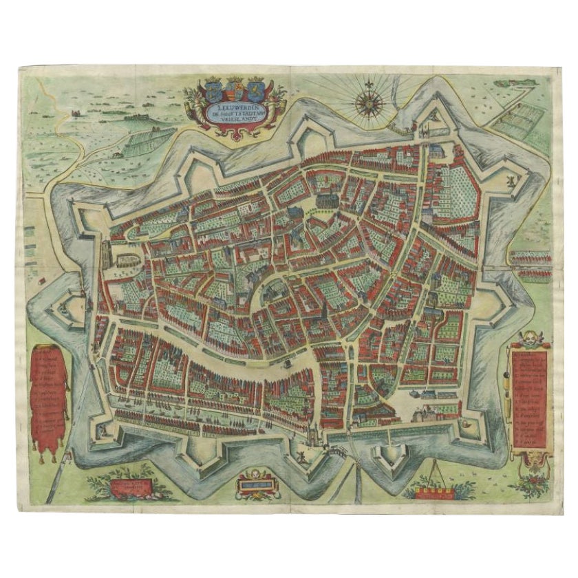
- Handcolored Rare Map of Leeuwarden, Capital of Friesland, The Netherlands, 1622Located in Langweer, NLAntique map titled 'Leeuwerden de Hooftstadt van Vrieslandt'. Rare and old map of the city of Leeuwarden, Friesland. Artists and Engravers: Published by Pieter Feddes van Harlingen...Category
Antique 17th Century Maps
MaterialsPaper
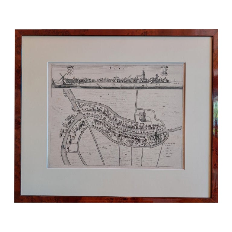
- Antique City View and Map of IJlst, City in Friesland, Holland, Framed, 1664Located in Langweer, NLAntique map titled 'Ylst'. Old map and city view of the city of IJlst, Friesland. This map originates from 'Beschrijvinge van de Heerlyckheydt van Frieslandt' by B. Schotanus à Sterr...Category
Antique 17th Century Maps
MaterialsPaper
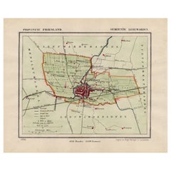
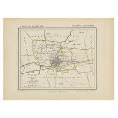
- Antique Map of Leeuwarden and Surroundings, in Friesland, the Netherlands, 1865Located in Langweer, NLFriesland: Gemeente Leeuwarden. These scarse detailed maps of Dutch Towns originate from the 'Gemeente-atlas' of Jacob Kuyper. This atlas of all towns in the Netherlands was publishe...Category
Antique 19th Century Maps
MaterialsPaper
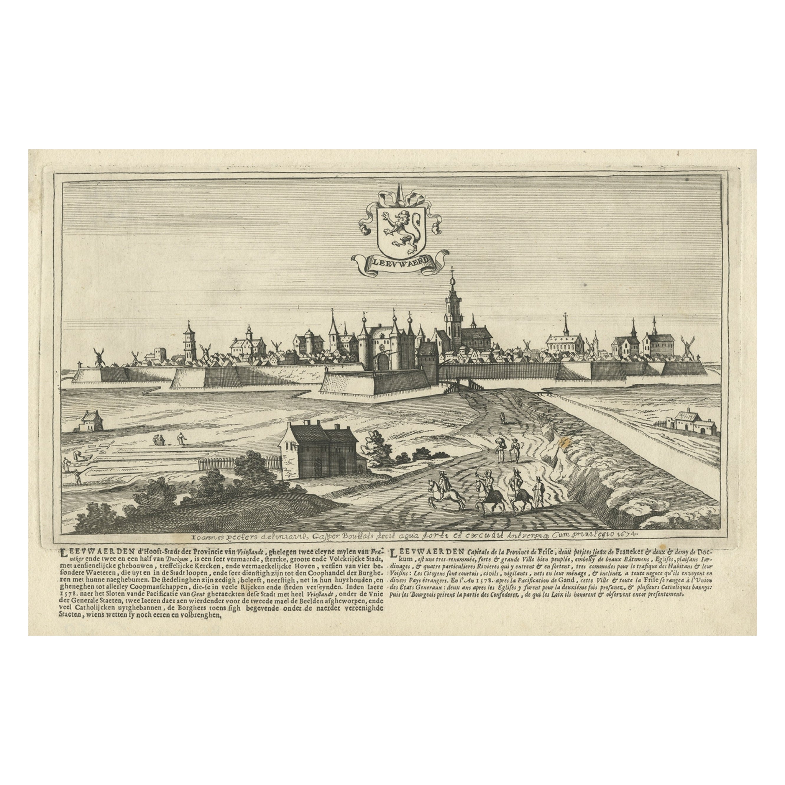
- Antique Print of the City of Leeuwarden, Friesland in The Netherlands, 1680Located in Langweer, NLAntique print titled 'Leeuwaerd'. Old bird's eye view of the city of Leeuwarden, Friesland. This print originates from 'Thooneel der Steden ende Sterckten van 't Vereenight Nederland...Category
Antique 17th Century Prints
MaterialsPaper
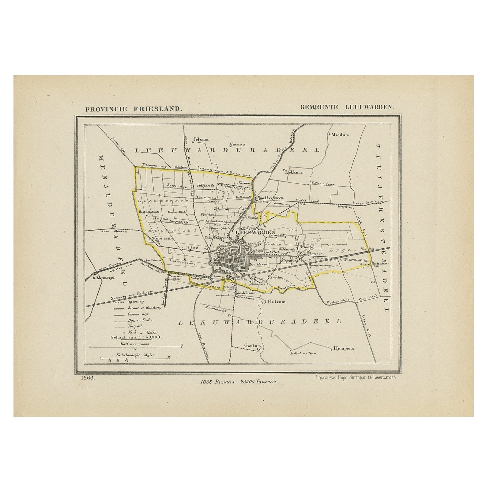
- Antique Map of Leeuwarden, Capital of Friesland, the Netherlands, 1868Located in Langweer, NLAntique map titled 'Provincie Friesland - Gemeente Leeuwarden'. Map of the township of Leeuwarden, Friesland. This map originates from 'Gemeente-Atlas van Nederland' by J. Kuyper. Ar...Category
Antique 19th Century Maps
MaterialsPaper

You May Also Like
- Antique Map of American Cities, Vignette of New York City, circa 1920Located in St Annes, LancashireGreat maps of American Cities Unframed Original color By John Bartholomew and Co. Edinburgh Geographical Institute Published, circa 1920Category
Vintage 1920s British Maps
MaterialsPaper
- Original Antique Map of the American State of Pennsylvania, 1889Located in St Annes, LancashireGreat map of Pennsylvania Drawn and Engraved by W. & A.K. Johnston Published By A & C Black, Edinburgh. Original colour Unframed. Repair to a minor tear on bottom edge.Category
Antique 1880s Scottish Victorian Maps
MaterialsPaper
- Original Antique Map of the American State of Washington, 1889Located in St Annes, LancashireGreat map of Washington Drawn and Engraved by W. & A.K. Johnston Published By A & C Black, Edinburgh. Original colour Unframed.Category
Antique 1880s Scottish Victorian Maps
MaterialsPaper
- Original Antique Map of the American State of Oregon, 1889Located in St Annes, LancashireGreat map of Oregon Drawn and Engraved by W. & A.K. Johnston Published By A & C Black, Edinburgh. Original colour Unframed.Category
Antique 1880s Scottish Victorian Maps
MaterialsPaper
- Large Original Antique Map of The World, Fullarton, C.1870Located in St Annes, LancashireGreat map of the World. Showing both hemispheres From the celebrated Royal Illustrated Atlas Lithograph. Original color. Published by Fullarton, Edinburgh, C.1870 Unframed. Rep...Category
Antique 1870s Scottish Maps
MaterialsPaper
- Large Original Antique Map of the United States of America. 1891By Rand McNally & Co.Located in St Annes, LancashireFabulous map of The United States Original color By Rand, McNally & Co. Dated 1891 Unframed Free shipping.Category
Antique 1890s American Maps
MaterialsPaper


Recently Viewed
View AllMore Ways To Browse
Antique City Views
London City Antiques
City Of London Antiques
Antique Cologne
Topographical Map
Antique German Portrait
Antwerp Table
London City Map
Antique City Plans
Antique 16th Century Tables
Antique Table Plans
Antique Topographic Maps
Antique Flemish Table
Antique Map Table
West German Antiques
Flemish Bird
Braun Germany
World Map Table