Items Similar to Antique Map of Leeuwarden and Surroundings, in Friesland, the Netherlands, 1865
Want more images or videos?
Request additional images or videos from the seller
1 of 7
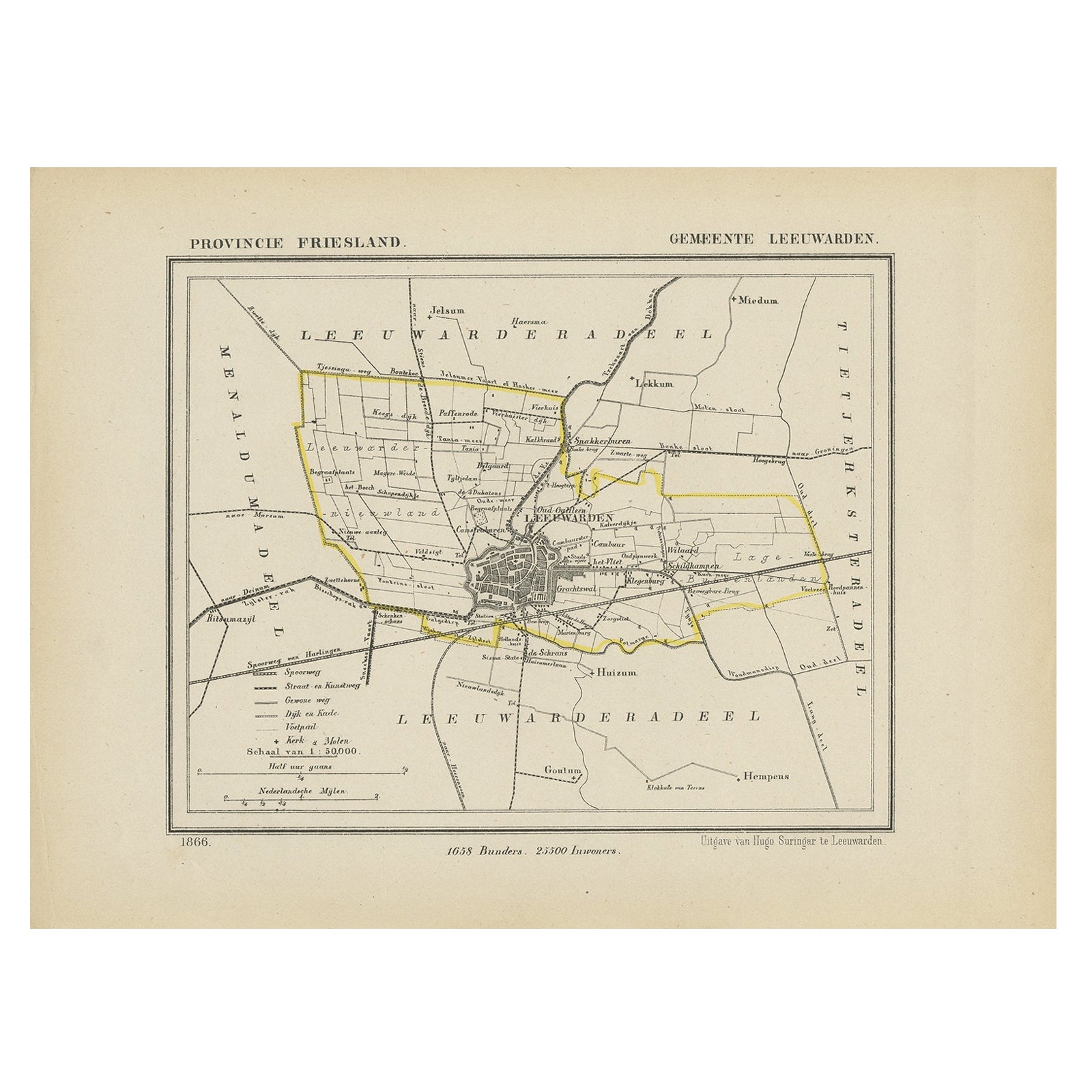
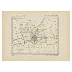
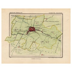
Antique Map of Leeuwarden and Surroundings, in Friesland, the Netherlands, 1865
About the Item
Friesland: Gemeente Leeuwarden. These scarse detailed maps of Dutch Towns originate from the 'Gemeente-atlas' of Jacob Kuyper. This atlas of all towns in the Netherlands was published from 1865-1870 and included all towns in the Dutch province of Friesland. These maps are also known as a Kuyper kaart or Kuyper kaartjes from Friesland.
Artists and Engravers: Author: Jacob Kuyper: He was one of the most important of the Dutch atlas editors of the second half of the 19th century. He is particularly known for the "Gemeente Atlas", with 1210 plans of all the towns and villages in the Netherlands.
Condition: Fine; occasional foxing as visible on the scans; sheet irregularly cut, not affecting image. Please study image carefully.
Date: 1865
Overall size: 25 x 19 cm.
Image size: 19.5 x 16.5 cm.
We sell original antique maps to collectors, historians, educators and interior decorators all over the world. Our collection includes a wide range of authentic antique maps from the 16th to the 20th centuries. Buying and collecting antique maps is a tradition that goes back hundreds of years. Antique maps have proved a richly rewarding investment over the past decade, thanks to a growing appreciation of their unique historical appeal. Today the decorative qualities of antique maps are widely recognized by interior designers who appreciate their beauty and design flexibility. Depending on the individual map, presentation, and context, a rare or antique map can be modern, traditional, abstract, figurative, serious or whimsical. We offer a wide range of authentic antique maps for any budget.
- Dimensions:Height: 7.49 in (19 cm)Width: 9.85 in (25 cm)Depth: 0 in (0.01 mm)
- Materials and Techniques:
- Period:
- Date of Manufacture:1865
- Condition:Condition: Fine; occasional foxing as visible on the scans; sheet irregularly cut, not affecting image. Please study image carefully.
- Seller Location:Langweer, NL
- Reference Number:
About the Seller
5.0
Platinum Seller
These expertly vetted sellers are 1stDibs' most experienced sellers and are rated highest by our customers.
Established in 2009
1stDibs seller since 2017
1,929 sales on 1stDibs
Typical response time: <1 hour
- ShippingRetrieving quote...Ships From: Langweer, Netherlands
- Return PolicyA return for this item may be initiated within 14 days of delivery.
More From This SellerView All
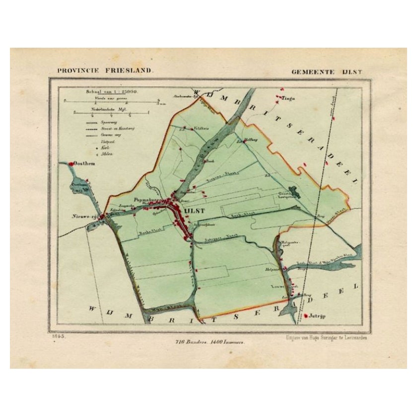
- Antique Map of Ijlst , Friesland in the Netherlands, 1865Located in Langweer, NLFriesland: Gemeente IjJlst. These scarse detailed maps of Dutch Towns originate from the 'Gemeente-atlas' of Jacob Kuyper. This atlas of all towns in the Netherlands was published fr...Category
Antique 19th Century Maps
MaterialsPaper
- Antique Map of Leeuwarden, Capital of Friesland, the Netherlands, 1868Located in Langweer, NLAntique map titled 'Provincie Friesland - Gemeente Leeuwarden'. Map of the township of Leeuwarden, Friesland. This map originates from 'Gemeente-Atlas van Nederland' by J. Kuyper. Ar...Category
Antique 19th Century Maps
MaterialsPaper
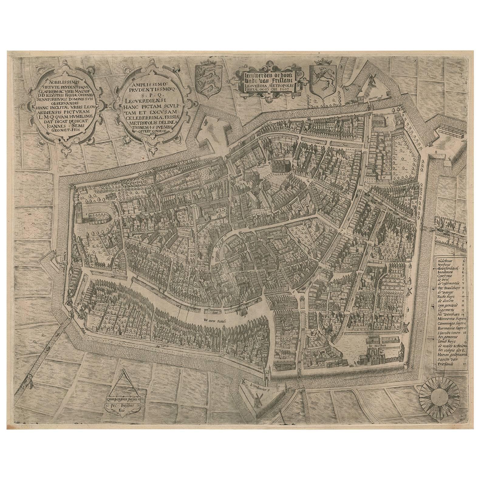
- VeryRare Antique Map of Leeuwarden, Friesland, The Netherlands, by P. Bast, 1603By P. BastLocated in Langweer, NLVery rare plan of Leeuwarden, Friesland, The Netherlands. With several cartouches and coat of arms. With a legend and compass rose at bottom right. Made by 'Pieter Bast' after the su...Category
Antique Early 17th Century Maps
MaterialsPaper
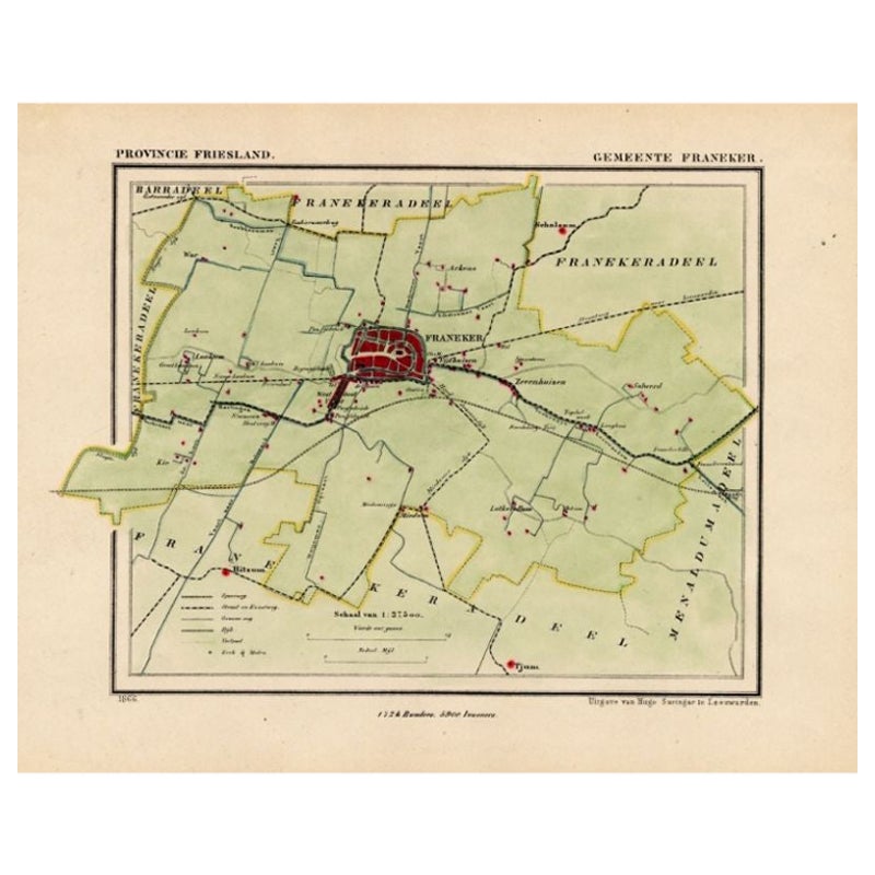
- Antique Map of the Township of Franeker in Friesland, the Netherlands, 1865Located in Langweer, NLFriesland: Gemeente Franeker. These scarse detailed maps of Dutch Towns originate from the 'Gemeente-atlas' of Jacob Kuyper. This atlas of all towns in the Netherlands was published ...Category
Antique 19th Century Maps
MaterialsPaper
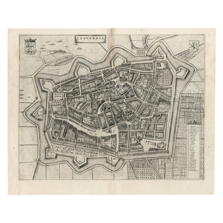
- Antique Map of Leeuwarden, Capital of Friesland, the Netherlands, by Blaeu, 1649Located in Langweer, NLAntique map titled 'Leoverdia.' Bird's-eye view plan of Leeuwarden, Friesland, the Netherlands. With key to locations and coats of arms. Text in Dutch on verso. This plan origina...Category
Antique 17th Century Maps
MaterialsPaper
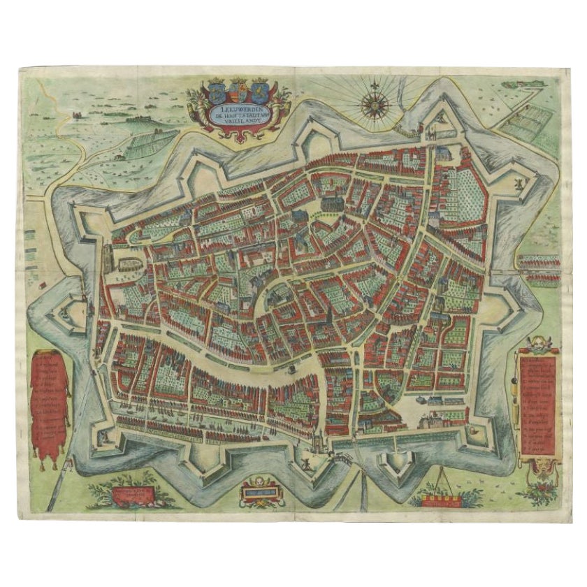
- Handcolored Rare Map of Leeuwarden, Capital of Friesland, The Netherlands, 1622Located in Langweer, NLAntique map titled 'Leeuwerden de Hooftstadt van Vrieslandt'. Rare and old map of the city of Leeuwarden, Friesland. Artists and Engravers: Published by Pieter Feddes van Harlingen...Category
Antique 17th Century Maps
MaterialsPaper

You May Also Like
- Original Antique Map of The Netherlands, Engraved by Barlow, Dated 1807Located in St Annes, LancashireGreat map of Netherlands Copper-plate engraving by Barlow Published by Brightly & Kinnersly, Bungay, Suffolk. Dated 1807 Unframed.Category
Antique Early 1800s English Maps
MaterialsPaper
- Original Antique Map of The Netherlands, Sherwood, Neely & Jones, Dated 1809Located in St Annes, LancashireGreat map of The Netherlands Copper-plate engraving by Cooper Published by Sherwood, Neely & Jones. Dated 1809 Unframed.Category
Antique Early 1800s English Maps
MaterialsPaper
- 1752 Vaugoundy Map of Flanders : Belgium, France, and the Netherlands, Ric.a002Located in Norton, MALarge Vaugoundy Map of Flanders: Belgium, France, and the Netherlands Colored -1752 Ric.a002 Description: This is a 1752 Didier Robert de Vaugondy map of Flanders. The map de...Category
Antique 17th Century Unknown Maps
MaterialsPaper
- School Chart or Pull Down Map of Geography of the Netherlands, 1950sLocated in Hemiksem, VANA beautiful old school map of the Netherlands, painted on linen. The map shows the 3 different reliefs (low, middle, high) of the Netherlands. The beau...Category
Vintage 1950s Belgian Mid-Century Modern Maps
MaterialsLinen, Paint
- 1865 "Johnson's Missouri and Kansas" Map by Johnson and WardLocated in Colorado Springs, COPresented is an original 1865 "Johnson's Missouri and Kansas” map. This map was issued as pages 59 and 60 in the 1865 edition of “Johnson's New Illustrated ...Category
Antique Mid-19th Century Maps
MaterialsPaper
- 1865 Chart of the Islands of MadeiraLocated in Norwell, MARare James Imray chart from 1865 titled "Chart of the Islands of Madeira, Porto Santo and Dezerea" drawn from the survey made by Captain Ate Vidal Royal Navy, London. Published by Ja...Category
Antique 1860s European Maps
MaterialsPaper


Recently Viewed
View AllMore Ways To Browse
Nebraska Map
Antique Map Of Massachusetts
Cornwall Map
Jeffery Brown
Antique Maps Kansas City
Hawaii Map Vintage
Hawaii Vintage Map
Vintage Hawaiian Map
Vintage Hawaiian Maps
Wyoming Map
Antique Montana Maps
Larousse Universel
Lebanon Antique Map
Livonia Map
Map Of Native American Tribes
Native American Tribes Map
Tanzania Antique Map
1847 Rio