Items Similar to Empire of the Parthians: Historical Cartographic Masterpiece by d'Anville, 1819


Want more images or videos?
Request additional images or videos from the seller
1 of 7
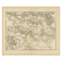
Empire of the Parthians: Historical Cartographic Masterpiece by d'Anville, 1819
$93.35
$116.6820% Off
£70.31
£87.8920% Off
€79.20
€9920% Off
CA$128.73
CA$160.9120% Off
A$144.62
A$180.7820% Off
CHF 75.57
CHF 94.4620% Off
MX$1,765.18
MX$2,206.4720% Off
NOK 959.46
NOK 1,199.3220% Off
SEK 903.13
SEK 1,128.9120% Off
DKK 602.84
DKK 753.5520% Off
About the Item
Description:
Ancient map of the Parthian Empire (19th century), original engraving extracted from the atlas of the history of the emperors from 1819, based on the history of the Roman emperors by Crevier, by d'Anville, the King's ordinary geographer. Note: Cyprus, the cities of Palmyra and Babylon, and the Tigris River are notably mentioned.
Description:
This detailed historical map, titled *"Empire des Parthes pour l'Histoire des Empereurs Romains,"* was created by the renowned French geographer Jean-Baptiste Bourguignon d'Anville. D'Anville was one of the most esteemed cartographers of the 18th century, known for his meticulous approach to mapmaking and his extensive use of ancient sources. This map focuses on the Parthian Empire, an ancient Iranian civilization that was a significant power in ancient Persia, rivaling the Roman Empire.
The map showcases the vast expanse of the Parthian Empire, stretching from the Euphrates River in the west to the borders of India in the east, and from the Caspian Sea in the north to the Persian Gulf in the south. Key regions such as Mesopotamia, Persia, and Bactria are prominently featured, with major cities including Seleucia, Ctesiphon, and Ecbatana. The map also highlights the routes and locations significant to the Roman emperors' campaigns, making it an invaluable resource for historians and collectors alike.
Important Places Featured on the Map:
- **Seleucia:** A major ancient city on the Tigris, near modern-day Baghdad, which was one of the main cities of the Parthian Empire.
- **Ctesiphon:** The capital city of the Parthian Empire, located near the Tigris River.
- **Ecbatana:** An ancient city that served as a summer residence for the Parthian kings.
- **Hecatompylos:** A significant city of the Parthian Empire, believed to be located near modern-day Damghan in Iran.
- **Susa:** An ancient city of the Elamite, Persian, and Parthian empires, near the modern-day Iranian city of Shush.
- **Bactra (Balkh):** One of the oldest cities in the world, located in the region of Bactria, now part of modern-day Afghanistan.
- **Sinope:** A city on the southern coast of the Black Sea, significant for its strategic location in ancient times.
- **Cyprus:** Featured prominently to show the extent of influence and routes connected with the Parthian Empire.
This map, engraved by Ambroise Tardieu, represents a significant historical period and offers insights into the geography of the ancient world as understood in the 18th century. D'Anville's work remains a cornerstone for collectors of historical maps and scholars of ancient history.
This description provides a good overview of the map, including its historical context, condition, and some of the key geographical features depicted.
- Dimensions:Height: 13.55 in (34.4 cm)Width: 19.69 in (50 cm)Depth: 0 in (0.02 mm)
- Materials and Techniques:Paper,Engraved
- Period:
- Date of Manufacture:1819
- Condition:Condition is Fair, with age-related traces, one small brown spot, and wear marks on the edges. Some dents but no holes. Otherwise, in good and clean condition.
- Seller Location:Langweer, NL
- Reference Number:Seller: BG-13746-141stDibs: LU3054341024342
About the Seller
5.0
Recognized Seller
These prestigious sellers are industry leaders and represent the highest echelon for item quality and design.
Platinum Seller
Premium sellers with a 4.7+ rating and 24-hour response times
Established in 2009
1stDibs seller since 2017
2,534 sales on 1stDibs
Typical response time: <1 hour
- ShippingRetrieving quote...Shipping from: Langweer, Netherlands
- Return Policy
Authenticity Guarantee
In the unlikely event there’s an issue with an item’s authenticity, contact us within 1 year for a full refund. DetailsMoney-Back Guarantee
If your item is not as described, is damaged in transit, or does not arrive, contact us within 7 days for a full refund. Details24-Hour Cancellation
You have a 24-hour grace period in which to reconsider your purchase, with no questions asked.Vetted Professional Sellers
Our world-class sellers must adhere to strict standards for service and quality, maintaining the integrity of our listings.Price-Match Guarantee
If you find that a seller listed the same item for a lower price elsewhere, we’ll match it.Trusted Global Delivery
Our best-in-class carrier network provides specialized shipping options worldwide, including custom delivery.More From This Seller
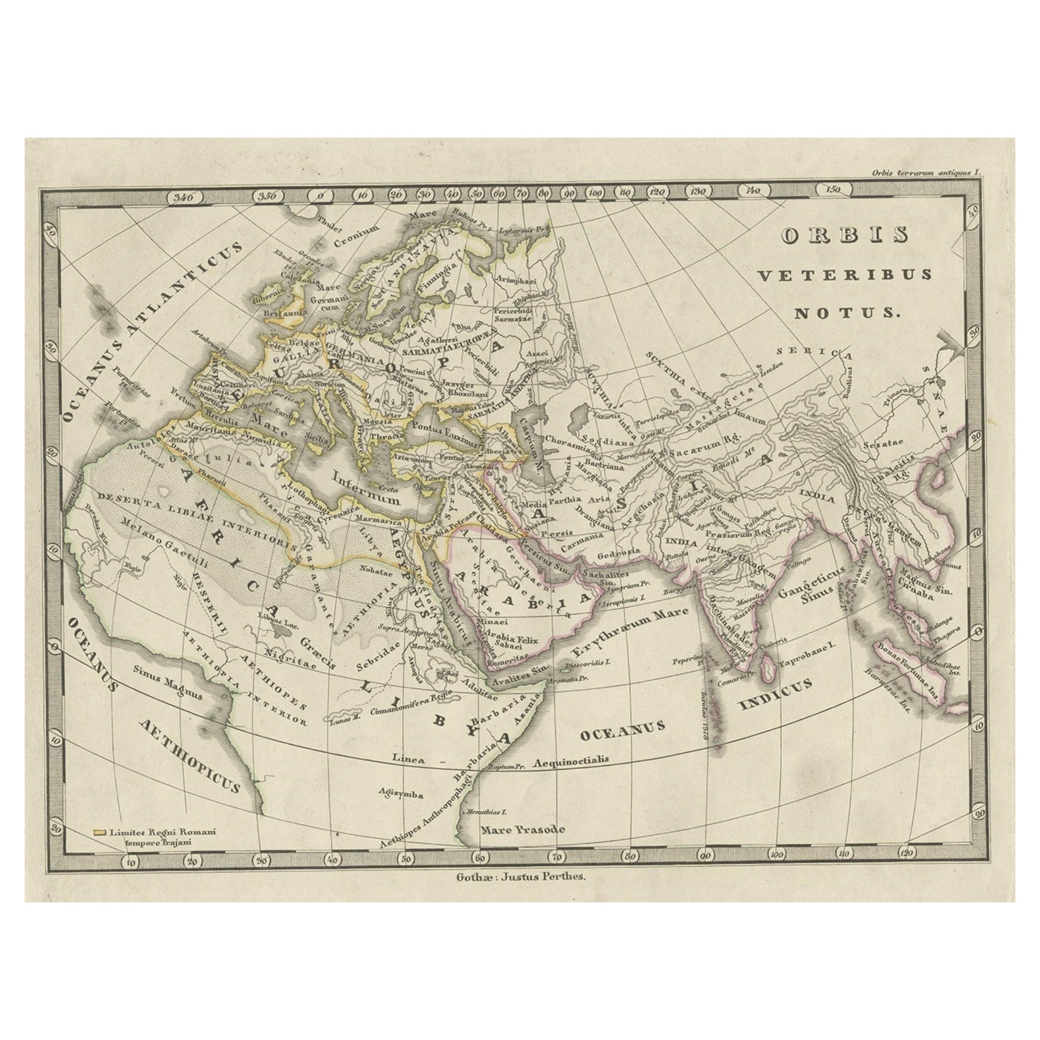
View AllAntique Map of Europe and Part of Asia and Africa, 1848
Located in Langweer, NL
Antique map titled 'Orbis Veteribus Notus'. Old map of the European continent, also depicting a portion of Asia and Africa. Originating from 'Orbis Terrarum Antiquus in usum Scholaru...
Category
Antique 19th Century Maps
Materials
Paper
$93 Sale Price
20% Off
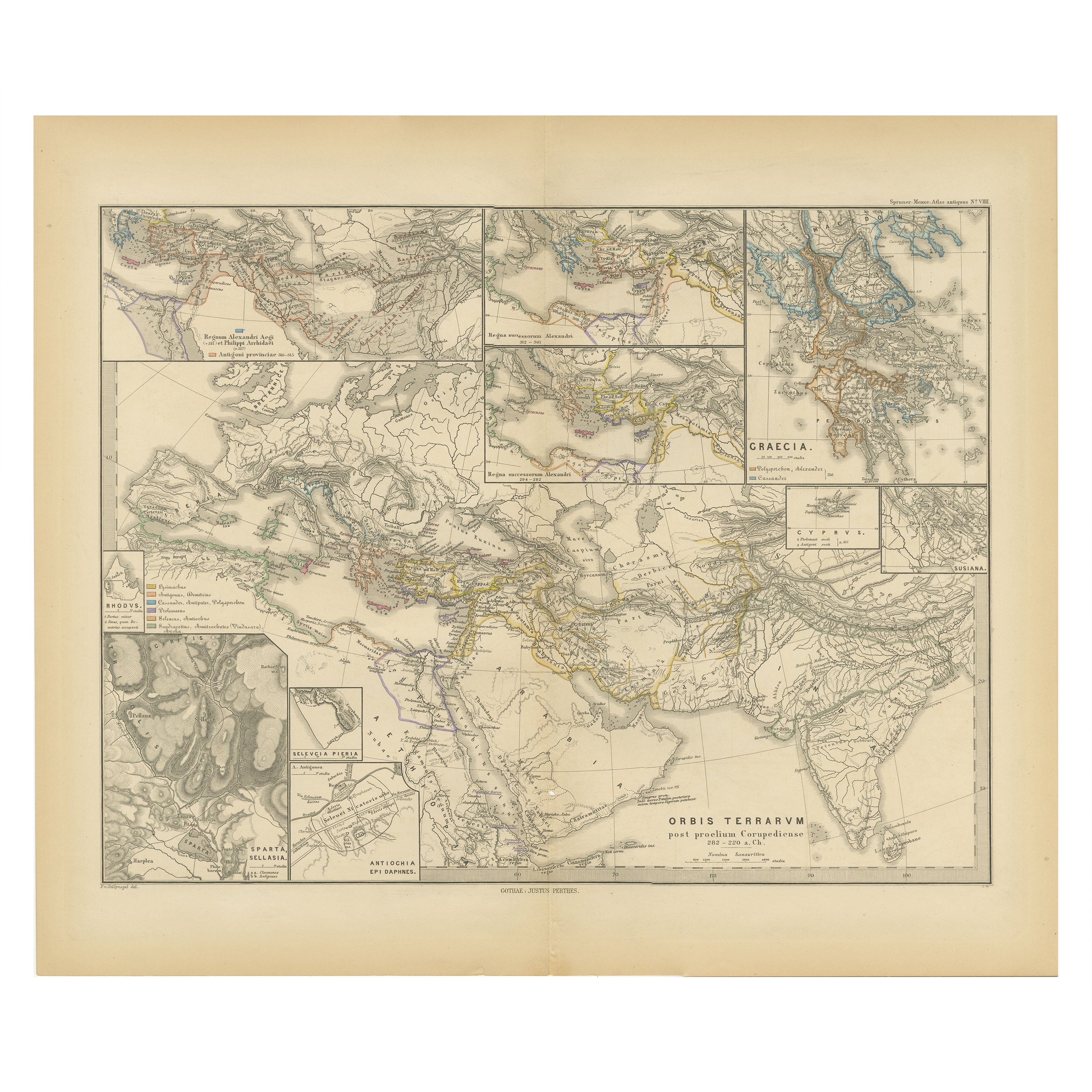
The World After the Battle of Corupedium: Hellenistic Kingdoms Map, 1880
Located in Langweer, NL
The map is titled "ORBIS TERRARUM post proelium Corupedinse," which translates to "The World after the Battle of Corupedium." This battle, which took place in 281 BC in Lydia, was th...
Category
Antique 1880s Maps
Materials
Paper
$349 Sale Price
20% Off
Free Shipping
Antique Map of the Turkish Empire by Tirion 'c.1760'
Located in Langweer, NL
Antique map titled 'Nieuwe Kaart van het Turksche Ryk gelegen in Europa, Asia en Africa'. Original antique map of the Turkish Empire. The map is centered on the Mediterranean Sea but...
Category
Antique Mid-18th Century Maps
Materials
Paper

$1,322 Sale Price
20% Off
Antique Map of the Persian Gulf and Caspian Sea Region by R. Bonne, 1780
Located in Langweer, NL
Antique print titled 'Carte de la Perse, de la Georgie, et de la Tartarie Independante'. Shows the region from the Persian Gulf and Caspian Sea in the wes...
Category
Antique Late 18th Century French Maps
Materials
Paper

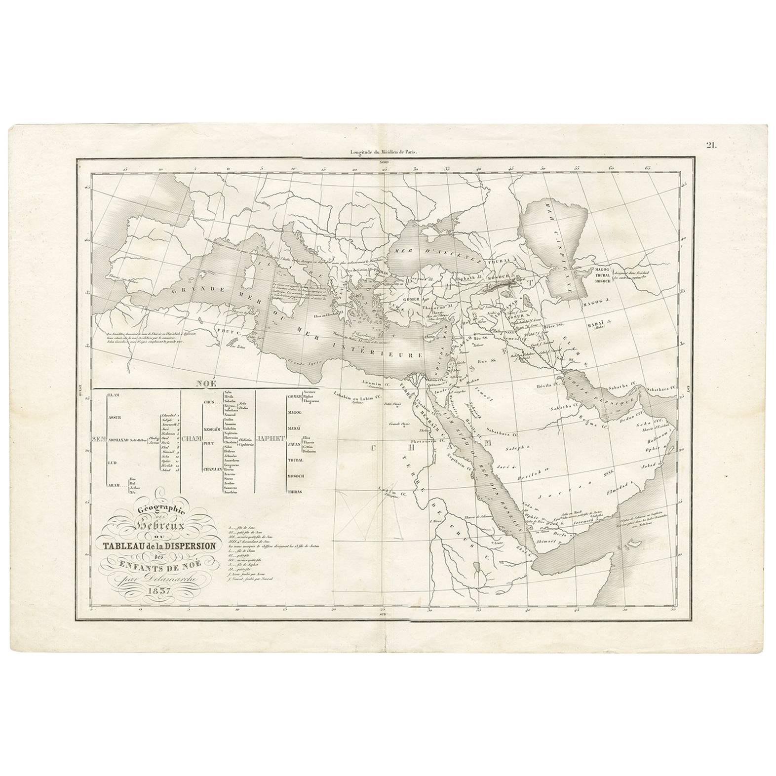
Géographie des Hébreux – Tableau de la Dispersion des Enfants de Noé, 1837
Located in Langweer, NL
Géographie des Hébreux – Tableau de la Dispersion des Enfants de Noé, 1837
This antique map, titled Géographie des Hébreux ou Tableau de la Dispersion des ...
Category
Antique Mid-19th Century French Maps
Materials
Paper
$226 Sale Price
20% Off
Antique Map of Asia by Dufour, circa 1834
Located in Langweer, NL
Antique map titled 'Asie par A.H. Dufour'. Uncommon map of Asia. Published by or after A.H. Dufour, circa 1834. Source unknown, to be determined.
Category
Antique Mid-19th Century Maps
Materials
Paper

$188 Sale Price
20% Off
You May Also Like
Original Antique Map of Europe, Arrowsmith, 1820
Located in St Annes, Lancashire
Great map of Europe
Drawn under the direction of Arrowsmith.
Copper-plate engraving.
Published by Longman, Hurst, Rees, Orme and Brown, 1820
...
Category
Antique 1820s English Maps
Materials
Paper

Original Antique Map of Ancient Greece, Achaia, Corinth, 1786
Located in St Annes, Lancashire
Great map of Ancient Greece. Showing the region of Thessaly, including Mount Olympus
Drawn by J.D. Barbie Du Bocage
Copper plate engraving by P.F Tardieu
Original hand color...
Category
Antique 1780s French Other Maps
Materials
Paper

Original Antique Map of The World by Thomas Clerk, 1817
Located in St Annes, Lancashire
Great map of The Eastern and Western Hemispheres
On 2 sheets
Copper-plate engraving
Drawn and engraved by Thomas Clerk, Edinburgh.
Published by Mackenzie And Dent, 1817
...
Category
Antique 1810s English Maps
Materials
Paper

Von Reilly Map of the Russian Empire, 1796
Located in Savannah, GA
A map of the Russian Empire in Europe by Von Reilly. Published in Vienna, 1796.
32 inches wide by 24 ½ inches tall
Category
Antique 1790s Austrian Prints
Materials
Glass, Wood, Paper

Original Antique Map of The Eastern Hemisphere by Dower, circa 1835
Located in St Annes, Lancashire
Nice map of the Eastern Hemisphere
Drawn and engraved by J.Dower
Published by Orr & Smith. C.1835
Unframed.
Free shipping
Category
Antique 1830s English Maps
Materials
Paper

Antique 1803 Italian Map of Asia Including China Indoneseia India
Located in Amsterdam, Noord Holland
Antique 1803 Italian Map of Asia Including China Indoneseia India
Very nice map of Asia. 1803.
Additional information:
Type: Map
Country of Manufacturing: Europe
Period: 19th centu...
Category
Antique 19th Century European Maps
Materials
Paper

$584 Sale Price
20% Off
More Ways To Browse
Antique Ancient Key
Iran Map
Ancient Babylon
Coffee Table Black Italian Modern
Christofle America
Iranian Silk Rug Carpet
Poul Moller
Tables With Inlaid Wood
World War Table
Antonio Jacobsen
Ariston Chairs
Coffee Tables Europe
Marble Top Dining Tables
Nordiska Argentina
Pink And Black Rug
Black Wooden Chair
Orrefors Embassy
Black Ebonized