Items Similar to Hand-Colored 18th Century Homann Map of the Black Sea, Turkey and Asia Minor


Want more images or videos?
Request additional images or videos from the seller
1 of 6
Hand-Colored 18th Century Homann Map of the Black Sea, Turkey and Asia Minor
$875
£668.98
€770.53
CA$1,226.14
A$1,368.87
CHF 717.27
MX$16,756.36
NOK 9,109.33
SEK 8,588.94
DKK 5,750.58
Shipping
Retrieving quote...The 1stDibs Promise:
Authenticity Guarantee,
Money-Back Guarantee,
24-Hour Cancellation
About the Item
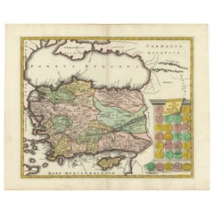
An attractive original early 18th century hand-colored map of the Black Sea and Turkey entitled "Carte de L'Asie Minevre ou de la Natolie et du Pont Evxin Tiree des Voyages et des Observations de Anciens et Modernes" (Map of Asia Miner or Natolia and the Pont Evxin Tiree from Voyages and Observations of Ancients and Moderns) by Johann Baptist Homann from his "Atlas Novus Terrarum", published in Nuremberg, Germany in 1728. This detailed map depicts Turkey and the area surrounding the Black Sea and the northern portions of the Mediterranean Sea, including parts of Greece, Macedonia, Crete, Romania, Russia, Ukraine, Crimea Armenia and Georgia. Turkey is shown as a series of regions named Caria, Lydia, Lycia, Pisidia, Pamphyllia, Cililicia, Cappa Docia, Phrygia Major, Phrygia Epictetos, Thynia, Mysia, Phrygia Minor, and Paphlagonia. An elaborate cartouche in the left upper corner is embellished by two ancient male and female warriors in combat, a temple, a bust of a heroic appearing man wearing a helmut surrounded by an arrow, a sword, an axe and a shield, as well as ancient architectural objects and symbols.
There is a central fold as issued, with slight separation inferiorly, which is reinforced on the verso. There is a small oblique crease in the right upper corner, mainly visible on the back and only faintly visible on the front. A small area of discoloration is present in the upper text on the right, but he map is otherwise in very good condition.
Johann Baptist Homann (1663-1724) was a mapmaker who founded a respected and prolific publishing company, which continued long after his death as Homann Heirs. Homann lived his entire life in Bavaria, particularly in Nuremberg. Initially, Johann trained to become a priest before converting to Protestantism and working as a notary. In 1702, Johann founded a publishing house that specialized in engravings. The firm flourished, becoming the leading map publisher in Germany and an important entity in the European map market. In 1715, Johann was named Imperial Geographer to the Holy Roman Empire by Charles VI and made a member of the Prussian Academy of Sciences. Most importantly for his business, his reputation and contacts gained him imperial printing privileges which protected his publications and recommended him to customers.
- Creator:Johann Baptist Homann (Artist)
- Dimensions:Height: 20 in (50.8 cm)Width: 23.63 in (60.03 cm)Depth: 0.07 in (1.78 mm)
- Materials and Techniques:Paper,Engraved
- Place of Origin:
- Period:
- Date of Manufacture:1728
- Condition:Wear consistent with age and use.
- Seller Location:Alamo, CA
- Reference Number:Seller: # 12921stDibs: LU5206219046972

Johann Baptist Homann
Johann Baptist Homann (1663-1724) was a mapmaker who founded a respected and prolific publishing company, which continued long after his death as Homann Heirs. Homann lived his entire life in Bavaria, particularly in Nuremberg. Initially, Johann trained to become a priest before converting to Protestantism and working as a notary. In 1702, Johann founded a publishing house that specialized in engravings. The firm flourished, becoming the leading map publisher in Germany and an important entity in the European map market. In 1715, Johann was named Imperial Geographer to the Holy Roman Empire by Charles VI and made a member of the Prussian Academy of Sciences. Most importantly for his business, his reputation and contacts gained him imperial printing privileges which protected his publications and recommended him to customers.
About the Seller
5.0
Vetted Professional Seller
Every seller passes strict standards for authenticity and reliability
1stDibs seller since 2020
15 sales on 1stDibs
- ShippingRetrieving quote...Shipping from: Alamo, CA
- Return Policy
Authenticity Guarantee
In the unlikely event there’s an issue with an item’s authenticity, contact us within 1 year for a full refund. DetailsMoney-Back Guarantee
If your item is not as described, is damaged in transit, or does not arrive, contact us within 7 days for a full refund. Details24-Hour Cancellation
You have a 24-hour grace period in which to reconsider your purchase, with no questions asked.Vetted Professional Sellers
Our world-class sellers must adhere to strict standards for service and quality, maintaining the integrity of our listings.Price-Match Guarantee
If you find that a seller listed the same item for a lower price elsewhere, we’ll match it.Trusted Global Delivery
Our best-in-class carrier network provides specialized shipping options worldwide, including custom delivery.More From This Seller
View AllHand-Colored 18th Century Homann Map of the Danube, Italy, Greece, Croatia
By Johann Baptist Homann
Located in Alamo, CA
"Fluviorum in Europa principis Danubii" is a hand colored map of the region about the Danube river created by Johann Baptist Homann (1663-1724) in his 'Atlas Novus Terrarum', publish...
Category
Antique Early 18th Century German Maps
Materials
Paper

Hand Colored 18th Century Homann Map of Austria Including Vienna and the Danube
By Johann Baptist Homann
Located in Alamo, CA
"Archiducatus Austriae inferioris" is a hand colored map of Austria created by Johann Baptist Homann (1663-1724) and published in Nuremberg, Germany in 1728 shortly after his death. ...
Category
Antique Early 18th Century German Maps
Materials
Paper

18th Century Hand-Colored Homann Map of Germany, Including Frankfurt and Berlin
By Johann Baptist Homann
Located in Alamo, CA
An 18th century hand-colored map entitled "Tabula Marchionatus Brandenburgici et Ducatus Pomeraniae quae sunt Pars Septentrionalis Circuli Saxoniae Superioris" by Johann Baptist Homa...
Category
Antique Early 18th Century German Maps
Materials
Paper

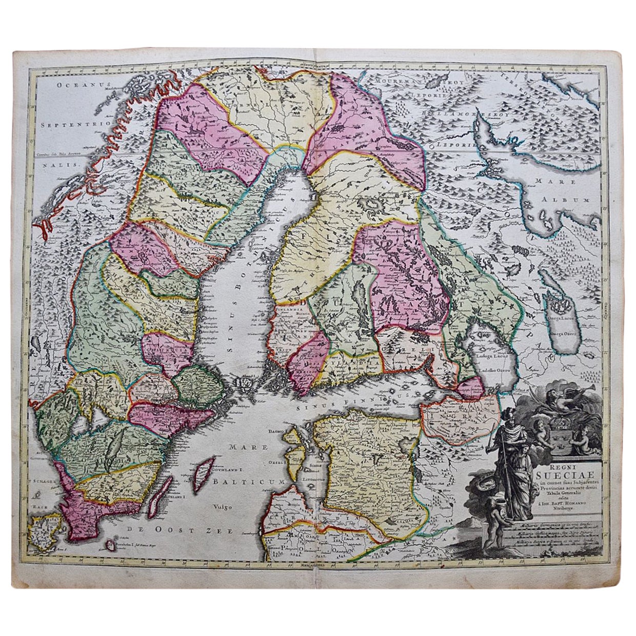
Scandinavia & Portions of Eastern Europe: 18th Century Hand-Colored Homann Map
By Johann Baptist Homann
Located in Alamo, CA
An early 18th century hand-colored copper-plate map entitled "Regni Sueciae in omnes suas Subjacentes Provincias accurate divisi Tabula Generalis" by Johann Baptist Homann (1663-1724...
Category
Antique Early 18th Century German Maps
Materials
Paper

Hand-Colored 18th Century Homann Map of Denmark and Islands in the Baltic Sea
By Johann Baptist Homann
Located in Alamo, CA
An 18th century copper plate hand-colored map entitled "Insulae Danicae in Mari Balthico Sitae utpote Zeelandia, Fionia, Langelandia, Lalandia, Falstria, Fembria Mona" created by Joh...
Category
Antique Early 18th Century German Maps
Materials
Paper

Southern Greece: A Large 17th C. Hand-colored Map by Sanson and Jaillot
By Nicolas Sanson
Located in Alamo, CA
This large original hand-colored copperplate engraved map of southern Greece and the Pelopponese Peninsula entitled "La Moree Et Les Isles De Zante, Cefalonie, Ste. Marie, Cerigo & C...
Category
Antique 1690s French Maps
Materials
Paper

You May Also Like
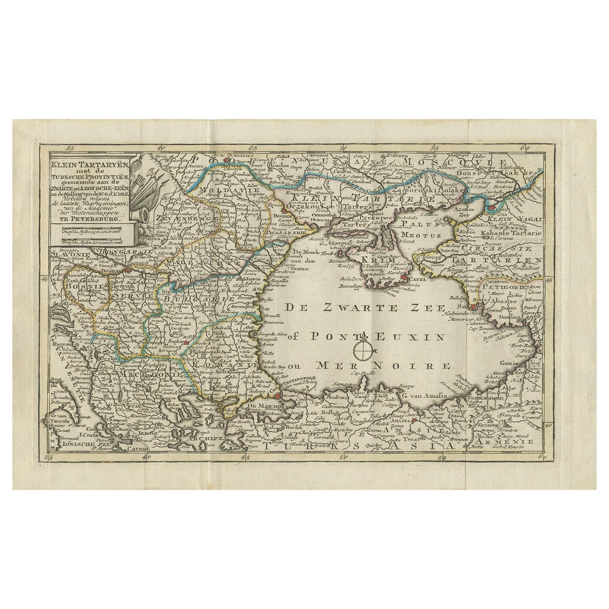
Antique Map of the Black Sea and Surroundings by Keizer & de Lat, 1788
Located in Langweer, NL
Antique map titled 'Klein Tartaryën met de Turksche Provintiën (..)'. Uncommon original antique map of the Black Sea and surroundings. This map originates from 'Nieuwe Natuur- Geschi...
Category
Antique Late 18th Century Maps
Materials
Paper
$330 Sale Price
20% Off
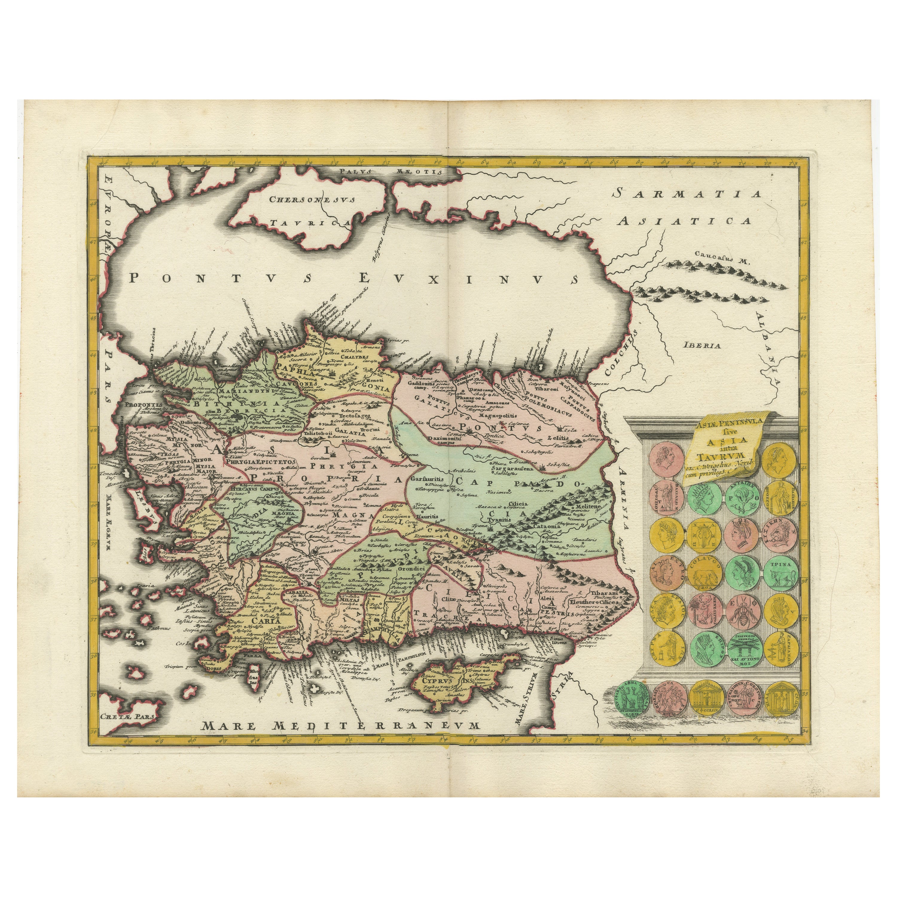
Decorative Antique Map of Cyprus and Asia Minor by Christoph Weigel, Circa 1720
Located in Langweer, NL
Title: Asiae Peninsula sive Asia Intra Taurum by Christoph Weigel, Circa 1720 – Decorative Antique Map of Cyprus and Asia Minor
Description: Thi...
Category
Antique 1720s Maps
Materials
Paper
$623 Sale Price
20% Off
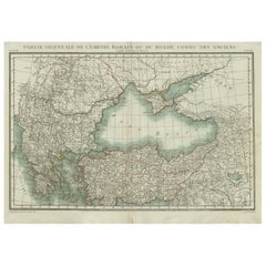
Black Sea & Eastern Mediterranean Map: Eastern Roman Empire, Tardieu Atlas, 1802
Located in Langweer, NL
Antique Map with Title: "Partie Orientale de l'Empire Romain ou du Monde connu des Anciens"
Publication Details:
- **Atlas Title:** Nouvel Atlas Universel de Géographie Ancienne e...
Category
Antique Early 1800s Maps
Materials
Paper
$491 Sale Price
20% Off
Antique Map of Turkey in Europe, c.1780
Located in Langweer, NL
Antique map titled 'Bowles's new pocket map of Turky in Europe divided into its Provinces'. Large map of Turkey in Europe. Source unknown, to be determined.
Artists and Engravers: Made by 'Thomas & Carington Bowles' after an anonymous artist. Thomas Bowles, born around 1712, was map publisher and seller in London...
Category
Antique 18th Century Maps
Materials
Paper
$340 Sale Price
20% Off
Orginal Antique Handcolored Map of the Turkish Empire, 1748
Located in Langweer, NL
Antique map titled 'L'Empire des Turcs'. Old map of the Turkish Empire with an inset of the North African regions. Originates from 'Atlas Nouveau Portatif' by G.L. le Rouge.
Artis...
Category
Antique 18th Century Maps
Materials
Paper
$337 Sale Price
35% Off
Antique Map of the Persian Gulf and Caspian Sea Region by R. Bonne, 1780
Located in Langweer, NL
Antique print titled 'Carte de la Perse, de la Georgie, et de la Tartarie Independante'. Shows the region from the Persian Gulf and Caspian Sea in the wes...
Category
Antique Late 18th Century French Maps
Materials
Paper

More Ways To Browse
Imperial German
Map Greece
Sword 18th Century
Maps Of Mediterranean
Hand Axe
Turkey Map
Antique Maps Of Greece
Antique Miners
Asian Arrow
Antique Crete
Roman Empire Map
Antique Map Of Georgia
Antique Macedonia
Antique Maps Of Russian Empire
Map Of Ancient Greece
Antique Map Of Turkish Empire
Romania Map
Ancient Roman Sword