Items Similar to Handcoloured Engraved Map of Amsterdam, Published in ca.1760

Want more images or videos?
Request additional images or videos from the seller
1 of 8
Handcoloured Engraved Map of Amsterdam, Published in ca.1760
$520.16
£391.63
€440
CA$717.90
A$804.20
CHF 418.29
MX$9,809.63
NOK 5,325.34
SEK 5,021.41
DKK 3,349.72
About the Item
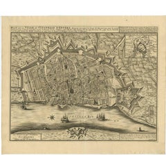
This original antique map titled "AMSTERDAM geconterfeyt door CORNELIS ANTHONISZOON, Schilder, en wtghegeven in't jaer 1544" is a handcolored engraved map, published by Jan Wagenaar and Isaak Tirion around 1760, based on an original map by Cornelis Anthonisz from 1544.
This historical map offers a detailed representation of Amsterdam in the mid-16th century.
Key Features and Landmarks on the Map:
1. De Aemstel (Amstel) River: The river that runs along the left side of the map, marking a significant natural feature of Amsterdam.
2. City Walls and Gates: Clearly visible fortifications surrounding the city, including multiple gates, such as the S. Olofs Poort and Oude zyids Houttuinen.
3. Churches and Monasteries: Important religious buildings are marked, including:
- S. Nicolaes Kerck (Church)
- S. Margrieten Kerck (Church)
- Oude Kerck (Old Church)
- Numerous monasteries such as S. Maerten-Klooster and S. Catharynen-Klooster.
4. Bridges and Roads: Infrastructure such as bridges (e.g., Papen brug) and main roads are well-defined, illustrating the city's connectivity.
5. Public Buildings: Notable public structures, including:
- The Town Hall (Stadhuis)
- Public squares like the Houtmarkt (Wood Market)
6. Waterways: Various canals and waterways intersect the city, reflecting Amsterdam's intricate canal system.
7. Defensive Structures: Towers and other defensive structures are shown, indicating the strategic importance of the city's fortifications.
Significance of the Map:
- **Historical Value**: The map provides an invaluable historical record of Amsterdam's layout and key structures as they existed in the mid-16th century, giving insight into the city's development and urban planning.
- **Cartographic Detail**: The detailed engraving and coloring highlight the craftsmanship and precision involved in mapmaking during this period.
- **Cultural Insight**: The map reflects the city's architecture, religious prominence, and infrastructure during a significant historical era, offering a glimpse into the past lifestyles and societal structure.
- **Educational Resource**: It serves as an educational tool for understanding historical geography, urban development, and the history of Amsterdam.
Overall, this map is a rich historical artifact that not only represents the physical layout of Amsterdam in the 1540s but also serves as a cultural and educational resource, showcasing the city's historical significance and the art of cartography in the 16th century.
The Original Maker of the Map:
Cornelis Anthonisz (also spelled Cornelis Anthoniszoon) was a notable figure in the history of Dutch cartography and art. Born around 1505 and living until 1553, he was a multifaceted artist known for his contributions as a painter, engraver, and mapmaker. His works provide valuable insights into the urban and architectural developments of his time.
Background and Career:
- **Birth and Death**: Cornelis Anthonisz was born around 1505 in Amsterdam and died in 1553.
- **Artistic Training**: He was trained as a painter and became well-versed in the techniques of engraving and cartography.
- **Professional Roles**: Anthonisz worked in various capacities, including as a painter and engraver, but he is most renowned for his detailed maps and bird’s-eye views of cities.
Major Contributions:
- **Map of Amsterdam (1544)**: One of his most famous works is the map of Amsterdam from 1544, which the map in question is based on. This map is significant for its detailed representation of the city’s layout, buildings, and infrastructure during the mid-16th century. It provides a bird's-eye view of the city, which was a relatively innovative approach at the time.
- **Innovative Techniques**: Anthonisz employed innovative techniques in his mapmaking, combining artistic skills with precise cartographic details. His works often included detailed engravings that depicted urban landscapes with remarkable accuracy.
Historical Significance:
- **Urban Documentation**: Anthonisz's maps are invaluable for historians and geographers as they offer detailed documentation of urban development during the Renaissance period. His work on Amsterdam, in particular, provides a snapshot of the city’s structure, architecture, and urban planning in the 1540s.
- **Artistic Legacy**: Beyond cartography, Anthonisz’s contributions to art and engraving have been recognized for their aesthetic quality and technical precision. His ability to blend artistic elements with practical cartographic information set a standard for future mapmakers.
- **Influence on Cartography**: Cornelis Anthonisz influenced the field of cartography significantly. His detailed and accurate maps became reference points for future generations of cartographers and contributed to the advancement of geographic knowledge in Europe.
Legacy:
- **Preservation of Works**: Many of Anthonisz's works, including his maps and engravings, are preserved in museums and archives, serving as important historical and artistic documents.
- **Recognition**: His contributions to cartography and art have been recognized by historians and scholars, and his maps continue to be studied for their historical value and craftsmanship.
Cornelis Anthonisz's map of Amsterdam from 1544 remains a crucial piece of historical cartography, reflecting both the urban landscape of the time and the advanced techniques used by the artist. His legacy endures in the detailed and beautifully crafted maps that provide a window into the past.
- Dimensions:Height: 12.88 in (32.7 cm)Width: 15.56 in (39.5 cm)Depth: 0.01 in (0.2 mm)
- Materials and Techniques:Paper,Engraved
- Period:1760-1769
- Date of Manufacture:circa 1760
- Condition:The map is in good condition with nice coloring and some age-related toning. It has a folding line in the middle, as issued.
- Seller Location:Langweer, NL
- Reference Number:Seller: BGI-010791stDibs: LU3054340472482
About the Seller
5.0
Recognized Seller
These prestigious sellers are industry leaders and represent the highest echelon for item quality and design.
Platinum Seller
Premium sellers with a 4.7+ rating and 24-hour response times
Established in 2009
1stDibs seller since 2017
2,531 sales on 1stDibs
Typical response time: <1 hour
- ShippingRetrieving quote...Shipping from: Langweer, Netherlands
- Return Policy
Authenticity Guarantee
In the unlikely event there’s an issue with an item’s authenticity, contact us within 1 year for a full refund. DetailsMoney-Back Guarantee
If your item is not as described, is damaged in transit, or does not arrive, contact us within 7 days for a full refund. Details24-Hour Cancellation
You have a 24-hour grace period in which to reconsider your purchase, with no questions asked.Vetted Professional Sellers
Our world-class sellers must adhere to strict standards for service and quality, maintaining the integrity of our listings.Price-Match Guarantee
If you find that a seller listed the same item for a lower price elsewhere, we’ll match it.Trusted Global Delivery
Our best-in-class carrier network provides specialized shipping options worldwide, including custom delivery.More From This Seller
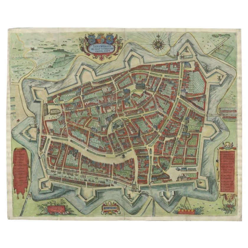
View AllHandcolored Rare Map of Leeuwarden, Capital of Friesland, The Netherlands, 1622
Located in Langweer, NL
Antique map titled 'Leeuwerden de Hooftstadt van Vrieslandt'. Rare and old map of the city of Leeuwarden, Friesland.
Artists and Engravers: Published by Pieter Feddes van Harlingen...
Category
Antique 17th Century Maps
Materials
Paper
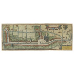
Dutch City Plan of Workum in Friesland by N. Van Geelkercken, hand-colored 1616
Located in Langweer, NL
Workum in Friesland by Nicolaes van Geelkercken, hand-colored map ca. 1616
This beautifully hand-colored engraving titled 'Worcum' presents an early 17th-century bird’s-eye view of ...
Category
Antique 1610s Dutch Maps
Materials
Paper
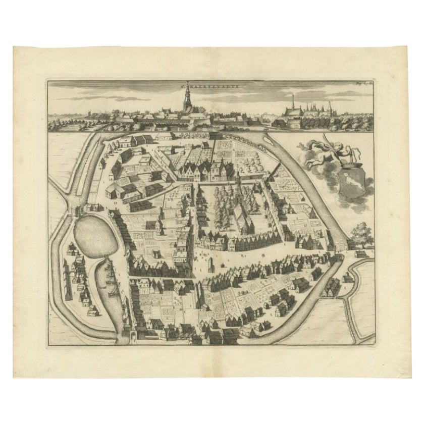
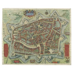
Antique Map of the City of Sint-Maartensdijk by Smallegange, c.1696
Located in Langweer, NL
Antique map titled 'St. Maertensdyk'. Original antique map of the city of Sint-Maartensdijk, the Netherlands. Source unknown, to be determined.
Artists and Engravers: Published b...
Category
Antique 17th Century Maps
Materials
Paper
$156 Sale Price
20% Off
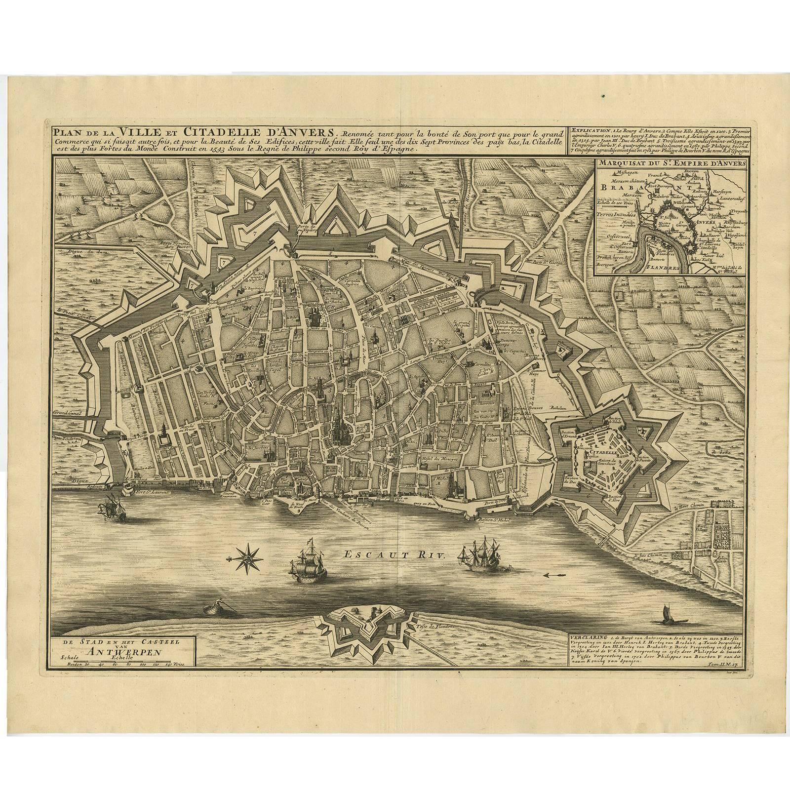
Antique Map of the City of Antwerpen ‘Belgium’ by A. Deur, 1729
Located in Langweer, NL
Copper-engraving by A. Deur. Published by I. van der Kloot in Den Haag, 1729. With French and Dutch title-cartouches and explanatory notes, several ships o...
Category
Antique Early 18th Century Maps
Materials
Paper
$728 Sale Price
20% Off
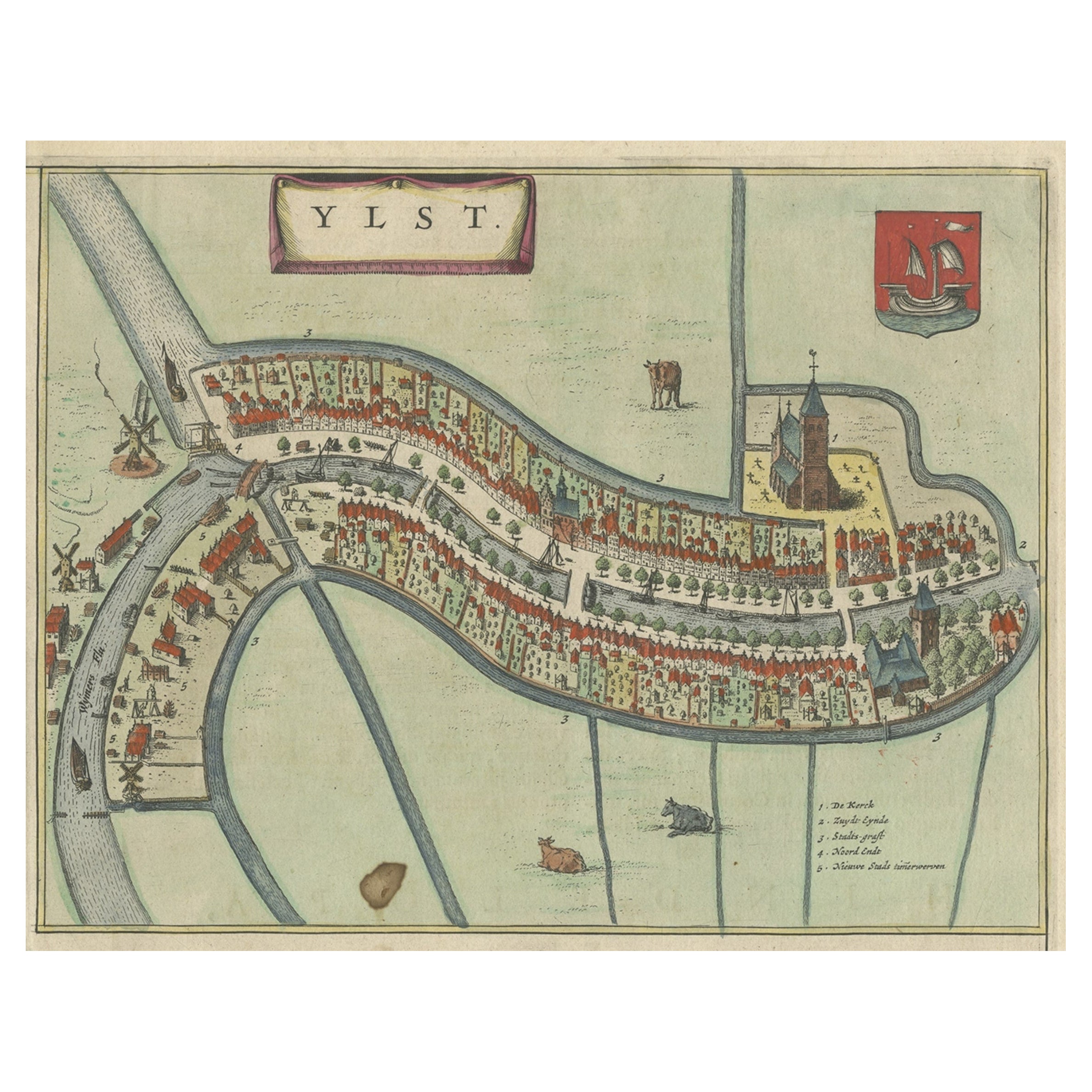
Antique Hand-Colored Map of the Frisian City of IJlst, The Netherlands, 1649
Located in Langweer, NL
Antique hand-colored map titled 'Ylst'. Original antique map of the city of IJlst, Friesland, the Netherlands.
This map originates from 'Novum Ac Magnum Theatrum Urbium Belgicae ...
Category
Antique 17th Century Maps
Materials
Paper

$354 Sale Price
20% Off
Hand-Colored Map of Delfland by Hendrik de Leth, 1740 – Delft & The Hague
Located in Langweer, NL
Hand-Colored Map of Delfland by Hendrik de Leth, 1740 – Delft & The Hague
This beautifully preserved antique map titled "Nieuwe Gemeete Kaert van Delfland" was engraved by Hendrik d...
Category
Antique 1740s Maps
Materials
Paper
You May Also Like
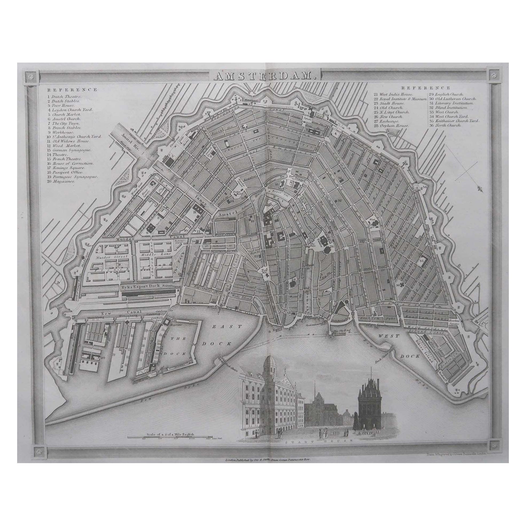
Original Antique Map or City Plan of Amsterdam, Netherlands. Circa 1835
Located in St Annes, Lancashire
Nice map of Amsterdam
Drawn and engraved by J.Dower
Published by Orr & Smith. C.1835
Unframed.
Free shipping
Category
Antique 1830s English Maps
Materials
Paper

Utrecht, Netherlands: A Large 17th Century Hand-colored Map by Sanson & Jaillot
By Nicholas Sanson d'Abbeville
Located in Alamo, CA
This large hand-colored map entitled "La Seigneurie d'Utrecht. Dressé sur les memoires les plus nouveaux par le Sr. Sanson" was originally created by Nicholas Sanson d'Abbeville. Thi...
Category
1690s Landscape Prints
Materials
Engraving

North Holland, Netherlands: A Large 17th C. Hand-colored Map by Sanson & Jaillot
By Nicholas Sanson d'Abbeville
Located in Alamo, CA
This large hand-colored map entitled "Le Comte De Hollande Dressee sur les Memoires les plus Nouveaux" was originally created by Nicholas Sanson d'Abbeville. This version was publish...
Category
1690s Landscape Prints
Materials
Engraving

Framed 1731 Color Engraving, Map of Rotterdam by Matthaus Seutter, "Roterodami"
Located in Bridgeport, CT
"Roterodami". Seutter (1678-1757) was an important German 18th century map maker. Bird's eye view of the city above with full details, neoclassi...
Category
Antique 18th Century European Renaissance Maps
Materials
Glass, Wood, Paper

Belgium and the Netherlands: A Hand-colored 17th Century Map by Visscher
By Nicolaus Visscher
Located in Alamo, CA
This is an original hand-colored 17th century map of Belgium by Nicolaus (Nicolas) Visscher II entitled "Belgium Foederatum emendate auctum et novissime editum", published in Amsterdam in 1678. The map shows the seven provinces comprising the Belgium federation or the Republic of the Seven United Netherlands or the Dutch Republic as it was also known. The republic was formed when an alliance of seven Dutch provinces in the Spanish Netherlands revolted against rule by Spain in 1579 (the Union of Utrecht) and declared their independence in 1581 (the Act of Abjuration). The seven provinces were Groningen, Frisia, Overijssel, Guelders, Utrecht, Holland and Zeeland. This was a predecessor state to the Netherlands and the first fully independent Dutch nation state. Amsterdam, Delft, Rouen, Utrecht, Brugge, Ghent, and Antwerp are all included on the map. A small inset map in the lower right depicts the course of the Maas River from Maastricht to Wessem. There is a decorative cartouche in the upper left corner and a distance scale cartouche in the lower right corner.
The map is presented in an attractive antiqued medium brown-colored wood frame with gold-colored inner and outer trim and a light tan-colored fabric mat. The frame measures 26.63" high by 30" wide by 0.75" deep. There is some darkening of the red areas in the map, presumably related to oxidation of the original iron containing pigment over time. There are also a few scattered spots. The map is otherwise in very good condition.
The Visscher family were one of the great cartographic families of the 17th century. Begun by Claes Jansz Visscher...
Category
Late 17th Century Other Art Style Landscape Prints
Materials
Engraving

18th Century Map Engraving - Newport, a Strong Sea-Port Town in Flanders
Located in Corsham, GB
A map of Nieuwpoort, anglicised to 'Newport', in northern Belgium. There is a panorama in the upper quarter depicting major landmarks. Below is a plan of the town, including its strong defences and ships at the port in the lower register. Inscribed with the title in plate to the lower edge, 'Newport a Strong Sea-Port Town...
Category
18th Century More Prints
Materials
Engraving

$269 Sale Price
20% Off
More Ways To Browse
Silver Over Copper
Vintage Barware Glasses
Coffee Table Black Italian Modern
Christofle America
Iranian Silk Rug Carpet
Poul Moller
Tables With Inlaid Wood
World War Table
Antonio Jacobsen
Ariston Chairs
Coffee Tables Europe
Marble Top Dining Tables
Nordiska Argentina
Pink And Black Rug
Black Wooden Chair
Orrefors Embassy
Black Ebonized
Elios Chair