Items Similar to Iberian Peninsula & Mediterranean Map: Western Roman Empire, by Tardieu, 1802

Want more images or videos?
Request additional images or videos from the seller
1 of 8
Iberian Peninsula & Mediterranean Map: Western Roman Empire, by Tardieu, 1802
$518.05
$647.5620% Off
£385.37
£481.7220% Off
€432
€54020% Off
CA$709.38
CA$886.7320% Off
A$788.74
A$985.9220% Off
CHF 411.83
CHF 514.7920% Off
MX$9,600.83
MX$12,001.0420% Off
NOK 5,254.82
NOK 6,568.5320% Off
SEK 4,923.52
SEK 6,154.4020% Off
DKK 3,288.58
DKK 4,110.7220% Off
Shipping
Retrieving quote...The 1stDibs Promise:
Authenticity Guarantee,
Money-Back Guarantee,
24-Hour Cancellation
About the Item
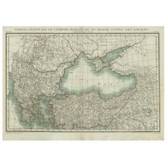
Antique Map with Title: "Partie Occidentale de l'Empire Romain ou du Monde connu des Anciens"
Publication Details:
- Atlas Title: Nouvel Atlas Universel de Géographie Ancienne et Moderne
- Purpose: For the Nouvelle Edition de la Géographie de Guthrie
- Mapmakers: P. F. Tardieu, with contributions from various geographical works
- Publisher: Chez Hyacinthe Langlois, Libraire, quai des Augustins, n° 45
- Year: An X - 1802 (French Revolutionary Calendar)
Geographical Scope:
This antique map illustrates the western part of the Roman Empire or the known world of the ancients. It focuses on the Iberian Peninsula, parts of Italy, and the Mediterranean region, including the northern coast of Africa.
Map Features:
- Regions Displayed* Iberian Peninsula (modern-day Spain and Portugal), parts of Italy, and the Mediterranean coast of northern Africa.
- Notable Regions and Territories: Hispania, Italia, Sicilia, Sardinia, Corsica, Mauretania Tingitana, Numidia, and Cyrenaica.
- Seas and Bodies of Water: Mediterranean Sea (Mare Mediterraneum), and parts of the Atlantic Ocean.
- Ancient Names: Uses historical and ancient names for countries, regions, and bodies of water.
- Topographical Details: Includes mountain ranges, rivers, and other significant geographical features as understood in the ancient world.
- Cartographic Style: Detailed engraving with hand-colored boundaries, typical of early 19th-century cartography, emphasizing historical accuracy and artistic presentation.
Purpose and Use:
This map serves as a visual representation of the western part of the Roman Empire, reflecting the geographical understanding and cartographic style of the early 19th century. It is part of a larger atlas that includes 60 maps, providing a comprehensive view of both ancient and modern geography as known in 1802.
Condition Report
The map is in good condition with minor age-related wear. Hand-colored boundaries are well-preserved, enhancing historical regions and features. Slight fold lines and edge wear are visible.
Coloring
The hand-colored boundaries on the map highlight ancient regions and territories, adding clarity and visual appeal, typical of early 19th-century cartographic practices.
- Dimensions:Height: 15.95 in (40.5 cm)Width: 22.84 in (58 cm)Depth: 0.01 in (0.2 mm)
- Materials and Techniques:Paper,Engraved
- Period:
- Date of Manufacture:1802
- Condition:The map is in good condition with minor age-related wear. Hand-colored boundaries are well-preserved, enhancing historical regions and features. Slight fold lines and edge wear are visible.
- Seller Location:Langweer, NL
- Reference Number:Seller: BG-13769-31stDibs: LU3054340556322
About the Seller
5.0
Recognized Seller
These prestigious sellers are industry leaders and represent the highest echelon for item quality and design.
Platinum Seller
Premium sellers with a 4.7+ rating and 24-hour response times
Established in 2009
1stDibs seller since 2017
2,510 sales on 1stDibs
Typical response time: <1 hour
- ShippingRetrieving quote...Shipping from: Langweer, Netherlands
- Return Policy
Authenticity Guarantee
In the unlikely event there’s an issue with an item’s authenticity, contact us within 1 year for a full refund. DetailsMoney-Back Guarantee
If your item is not as described, is damaged in transit, or does not arrive, contact us within 7 days for a full refund. Details24-Hour Cancellation
You have a 24-hour grace period in which to reconsider your purchase, with no questions asked.Vetted Professional Sellers
Our world-class sellers must adhere to strict standards for service and quality, maintaining the integrity of our listings.Price-Match Guarantee
If you find that a seller listed the same item for a lower price elsewhere, we’ll match it.Trusted Global Delivery
Our best-in-class carrier network provides specialized shipping options worldwide, including custom delivery.More From This Seller
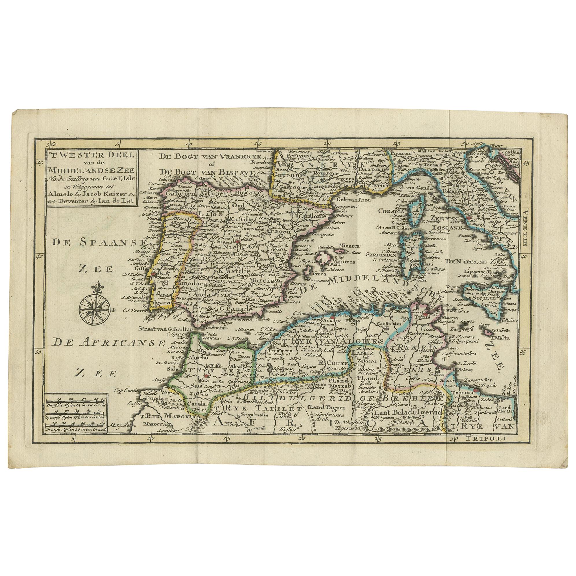
View AllAntique Map of the Mediterranean Sea and Surroundings by Keizer & de Lat, 1788
Located in Langweer, NL
Antique map titled 't Wester Deel van de Middelandse Zee (..)'. Uncommon original antique map of the Mediterranean Sea and surroundings. This map originates from 'Nieuwe Natuur- Gesc...
Category
Antique Late 18th Century Maps
Materials
Paper

$335 Sale Price
20% Off
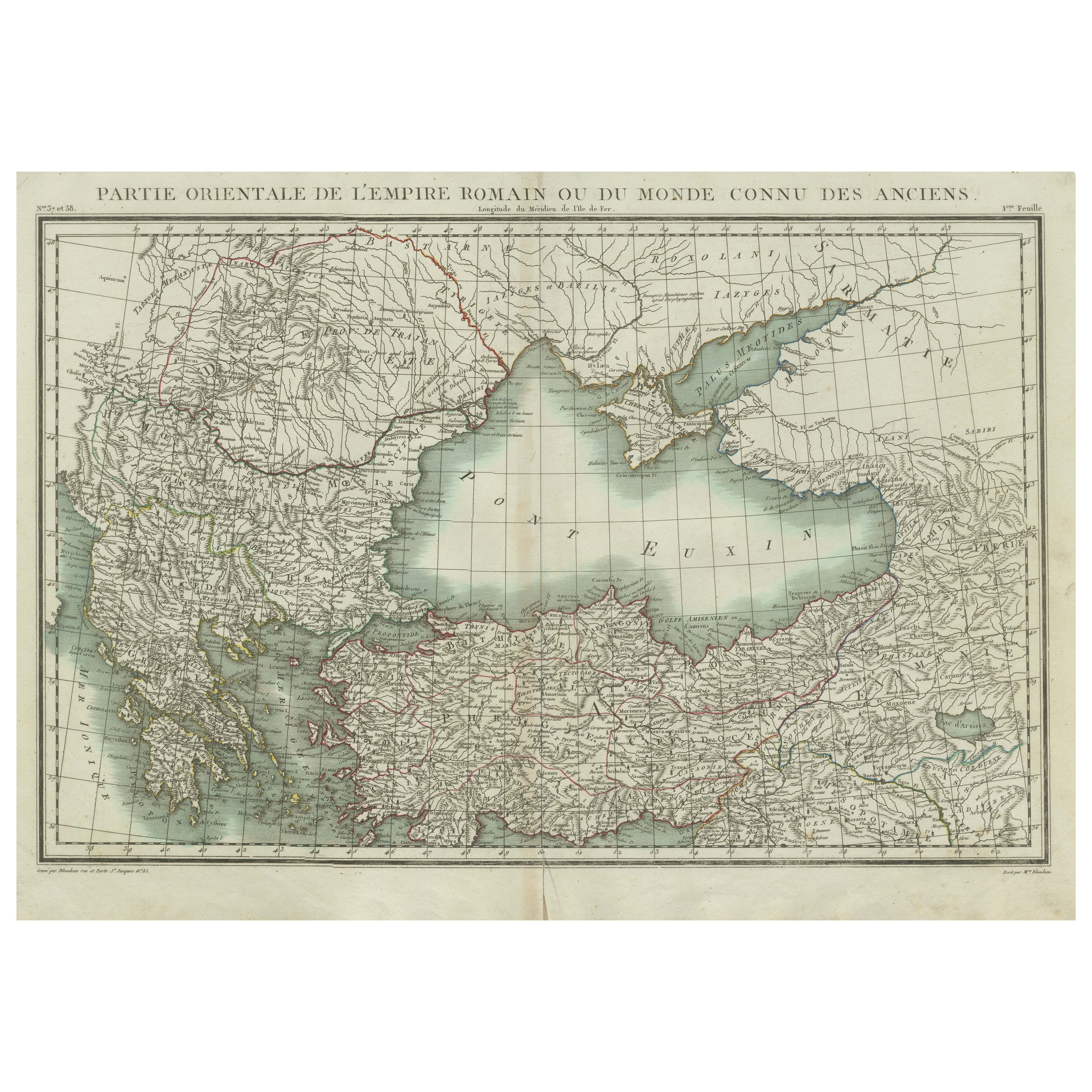
Black Sea & Eastern Mediterranean Map: Eastern Roman Empire, Tardieu Atlas, 1802
Located in Langweer, NL
Antique Map with Title: "Partie Orientale de l'Empire Romain ou du Monde connu des Anciens"
Publication Details:
- **Atlas Title:** Nouvel Atlas Universel de Géographie Ancienne e...
Category
Antique Early 1800s Maps
Materials
Paper
$498 Sale Price
20% Off
Antique Map of the Northern Coast of Africa and Southern Europe, circa 1745
By Covens & Mortier
Located in Langweer, NL
Antique map titled 'In Notitiam Ecclesiasticam Africae Tabula Geographica'. Very decorative hand-colored map of the northern coast of Africa, Spain, Italy and the Mediterranean with the islands of Sardinia, Corsica, Majorca, Minorca etc. Sicily features a smoking Mount Aetna. Embellished with three architectural cartouches...
Category
Antique Mid-18th Century Maps
Materials
Paper

$306 Sale Price
67% Off
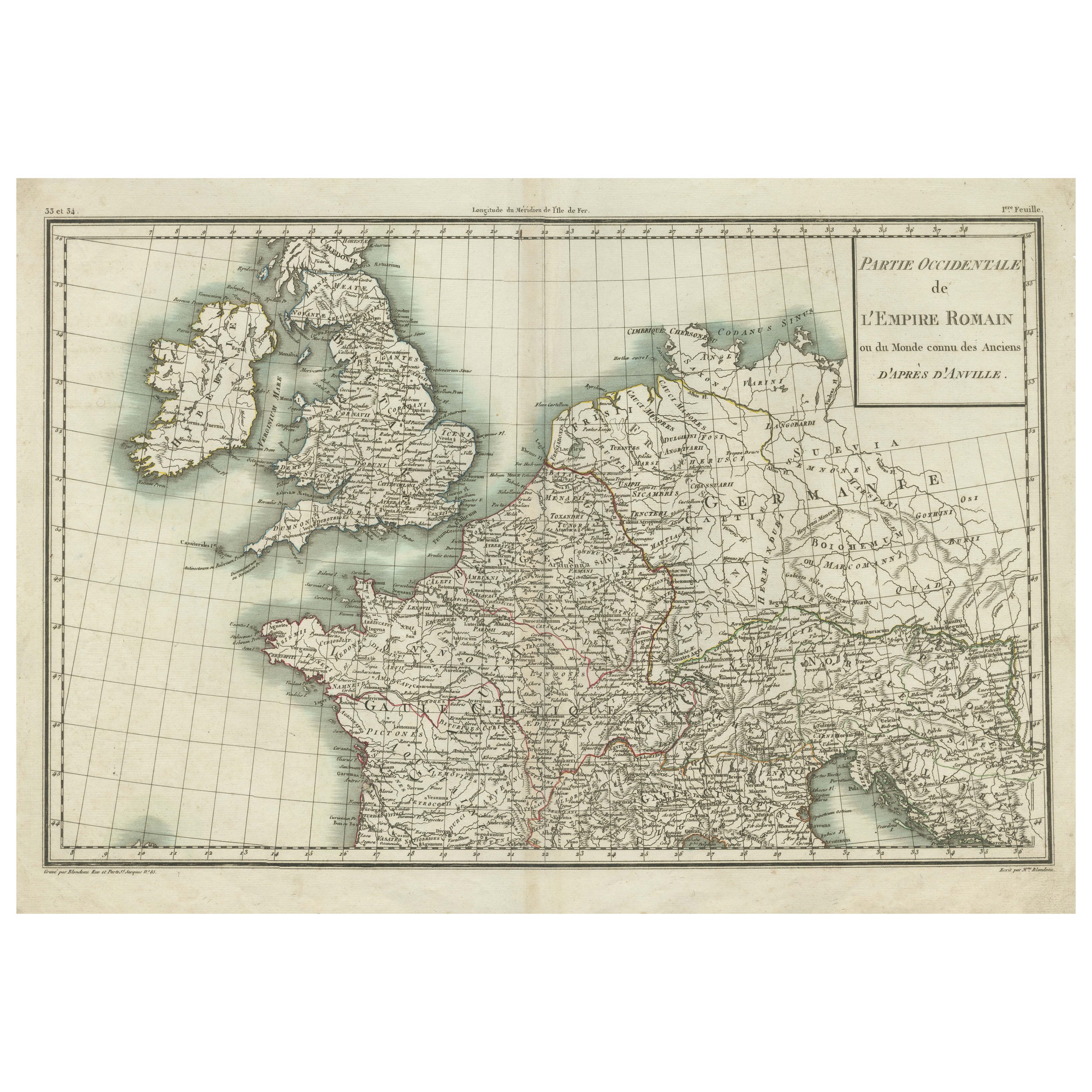
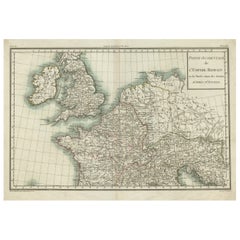
Western Roman Empire Map: British Isles & Gaul - 1802 Tardieu Atlas
Located in Langweer, NL
Antique Map Description and title: "Partie Occidentale de l'Empire Romain ou du Monde connu des Anciens d'Après d'Anville"
Publication Details:
- **Atlas Title:** Nouvel Atlas Univ...
Category
Antique Early 1800s Maps
Materials
Paper
$422 Sale Price
20% Off
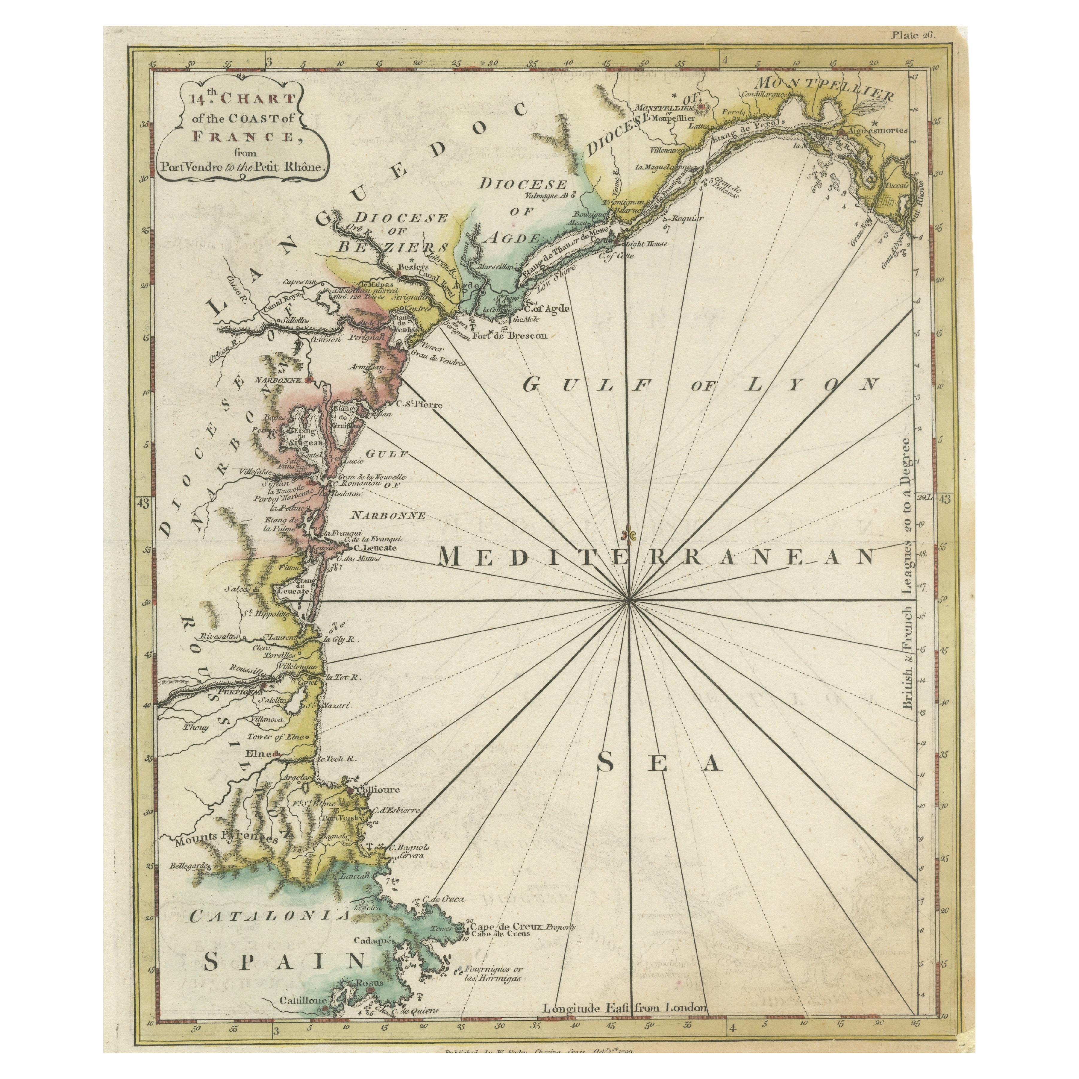
Antique Map of the Coast of Southern France, 1793
Located in Langweer, NL
Antique map titled '14th Chart of the Coast of France, from Port Vendres to the Petit Rhône'. Original map with later hand coroling of the coast of Southern France.
The "14th Chart of the Coast of France, from Port Vendres to the Petit Rhône" is an antique map that offers a detailed depiction of the southern coast of France, specifically highlighting the Mediterranean coastline. This map, which dates back to 1793, was originally part of "Le Petit Neptune Français; Or, French Coasting Pilot," a publication designed for maritime navigation along the French coastlines.
Key Features of the Map:
1. **Geographic Coverage**:
- The map covers the southern French coastline from Port Vendres in the west to the Petit Rhône in the east.
- It includes notable regions such as Languedoc, the Gulf of Lyon, and parts of Catalonia (Spain).
2. **Notable Places**:
- **Montpellier**: A major city in the Diocese of Montpellier, an important cultural and economic center.
- **Narbonne**: Located in the Diocese of Narbonne, a historical city with Roman heritage.
- **Agde**: Situated in the Diocese of Agde, known for its ancient Greek colony origins.
- **Béziers**: Part of the Diocese of Béziers, another city with deep historical roots dating back to Roman times.
- **Port Vendres**: A critical port near the Spanish border.
- **Catalonia**: Including parts of northeastern Spain, emphasizing the coastal connection between France and Spain.
3. **Dioceses and Regions**:
- The map is marked with various dioceses such as Montpellier, Agde, Narbonne, and Béziers, indicating ecclesiastical boundaries.
- It highlights the broader region of Languedoc, a historical province known for its wine production and medieval history.
4. **Navigational Aids**:
- The map features a compass rose with radiating lines, a common navigational aid in maritime maps...
Category
Antique Late 18th Century Maps
Materials
Paper

$230 Sale Price
20% Off
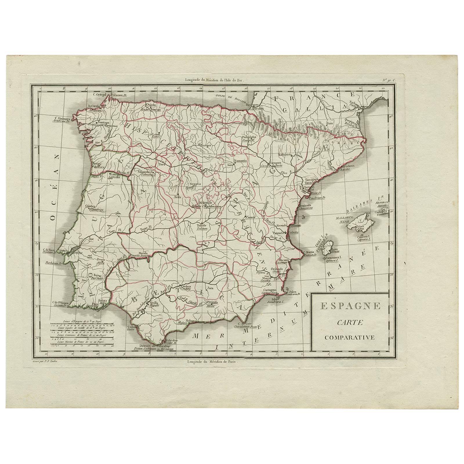
Antique Map of Spain by P.F. Tardieu, circa 1798
By Pierre François Tardieu
Located in Langweer, NL
Antique map titled 'Espagne carte comparative', showing river systems, the modern states of Spain and Portugal and the Roman provinces of Lusitania, Beatica & Hispania Tarraconensis....
Category
Antique Late 18th Century Maps
Materials
Paper
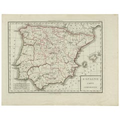
$167 Sale Price
20% Off
You May Also Like
Original Antique Map of Spain and Portugal, circa 1790
Located in St Annes, Lancashire
Super map of Spain and Portugal
Copper plate engraving by A. Bell
Published, circa 1790.
Unframed.
Category
Antique 1790s English Other Maps
Materials
Paper

Original Antique Map of Ancient Greece, Achaia, Corinth, 1786
Located in St Annes, Lancashire
Great map of Ancient Greece. Showing the region of Thessaly, including Mount Olympus
Drawn by J.D. Barbie Du Bocage
Copper plate engraving by P.F Tardieu
Original hand color...
Category
Antique 1780s French Other Maps
Materials
Paper

Original Antique Map of Europe, Arrowsmith, 1820
Located in St Annes, Lancashire
Great map of Europe
Drawn under the direction of Arrowsmith.
Copper-plate engraving.
Published by Longman, Hurst, Rees, Orme and Brown, 1820
...
Category
Antique 1820s English Maps
Materials
Paper

1751 Map of Spain Castilla Robert De Vaugondy 1st Edition, Ric.a001
Located in Norton, MA
Large Spain Castilla Robert De Vaugondy
1751 1st Edition
-Colored- Ric.a001
Coming from a family of cartographers, a descendant of the famous Nicolas Sanson and ordinary geographer of the king, Gilles Robert de Vaugondy makes himself known by his maps of the French provinces.
He published an Essay on the History of Geography (1755) from which he excluded the physical geography "too systematic". After a Small Atlas (1748), he draws a universal Atlas (1758), a portable Atlas (1762).
His Atlas of the revolutions of the globe remains unpublished. His warnings and prefaces, his book reviews reveal a Cartesian mind and solid knowledge.
Very early, he associates with his works his son Didier who publishes, since 1742, the methodical tables of Nicolas Sanson, two Globes, one terrestrial, the other celestial (1752).
He is credited with a map of Poland...
Category
Antique 18th Century Unknown Maps
Materials
Paper

Hand-Colored 18th Century Homann Map of the Black Sea, Turkey and Asia Minor
By Johann Baptist Homann
Located in Alamo, CA
An attractive original early 18th century hand-colored map of the Black Sea and Turkey entitled "Carte de L'Asie Minevre ou de la Natolie et du Pont Evxin Tiree des Voyages et des Ob...
Category
Antique Early 18th Century German Maps
Materials
Paper

Southern Greece: A Large 17th C. Hand-colored Map by Sanson and Jaillot
By Nicolas Sanson
Located in Alamo, CA
This large original hand-colored copperplate engraved map of southern Greece and the Pelopponese Peninsula entitled "La Moree Et Les Isles De Zante, Cefalonie, Ste. Marie, Cerigo & C...
Category
Antique 1690s French Maps
Materials
Paper

More Ways To Browse
Mediterranean Antique
Silver Over Copper
Vintage Barware Glasses
Coffee Table Black Italian Modern
Christofle America
Iranian Silk Rug Carpet
Poul Moller
Tables With Inlaid Wood
World War Table
Antonio Jacobsen
Ariston Chairs
Coffee Tables Europe
Marble Top Dining Tables
Nordiska Argentina
Pink And Black Rug
Black Wooden Chair
Orrefors Embassy
Black Ebonized