Items Similar to Italia Antiqua Philippo Cluvero – 1603 Hondius Map of Ancient Italy, Handcolored


Want more images or videos?
Request additional images or videos from the seller
1 of 11
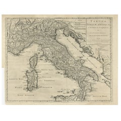
Italia Antiqua Philippo Cluvero – 1603 Hondius Map of Ancient Italy, Handcolored
$1,654.03
£1,239.80
€1,400
CA$2,272.36
A$2,536.88
CHF 1,329.29
MX$31,053.87
NOK 16,881.94
SEK 15,917.53
DKK 10,657.31
Shipping
Retrieving quote...The 1stDibs Promise:
Authenticity Guarantee,
Money-Back Guarantee,
24-Hour Cancellation
About the Item
Italia Antiqua Philippo Cluvero – 1603 Hondius Map of Ancient Italy with Hand Color
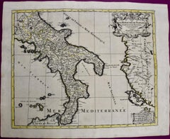
This stunning early 17th-century map, *Italia Antiqua Philippo Cluvero Borusso Designatore*, was published in 1603 by Jodocus Hondius as part of Philipp Cluver’s 'Theatrum Geographiae Veteris', a foundational work in historical geography. The map is a meticulously engraved depiction of ancient Italy, incorporating classical sources and cartographic expertise from Theodorus Cluver.
Covering the Italian peninsula, the map also includes the islands of Sardinia and Corsica, as well as the northern part of Sicily. It is adorned with Latin place names, referencing ancient Roman and Greek geography, making it an invaluable historical resource. The map is enriched with stunning embellishments, including a decorative title cartouche featuring two allegorical figures—one representing peace and the other war—highlighting Italy’s complex historical narrative. A second strapwork cartouche in the upper right lists prominent authors who have written about Italy, underscoring the scholarly nature of this map.
Jodocus Hondius, one of the most significant Dutch engravers and publishers of the time, ensured that this map maintained the highest artistic and technical quality. The background features elaborate details, such as a large sailing galleon off the western coast, finely engraved mountains, and rivers rendered in delicate shading. The pictorial relief and hand-applied color enhance the visual appeal, making this map both a geographical study and a work of art.
This edition was published in 1618 with Latin text on the verso, indicating its inclusion in the first edition of 'Theatrum Geographiae Veteris'. It is referenced in Van der Krogt, confirming its place among important historical maps of Italy.
Condition: Very good to excellent. A strong, dark impression with original hand color. A professionally repaired centerfold separation within the image does not detract from its visual integrity. Minor toning along the edges of the sheet, consistent with age, adds to its authentic antique character.
Framing Advice: To preserve and display this exceptional map, consider using an acid-free, museum-grade mat and UV-protective glass or acrylic to prevent fading. A gold or dark wood frame with a classical style complements the historical elegance of the piece. If possible, opt for conservation mounting, which avoids adhesives directly on the map and allows for future removal without damage. Proper framing will not only enhance its aesthetic appeal but also protect this rare historical artifact for generations to come.
This rare and historically significant map is a must-have for collectors of antique maps, scholars of classical geography, and enthusiasts of Italian history.
- Dimensions:Height: 14.3 in (36.3 cm)Width: 19.49 in (49.5 cm)Depth: 0.01 in (0.2 mm)
- Materials and Techniques:Paper,Engraved
- Period:1600-1609
- Date of Manufacture:1603
- Condition:Very good to excellent. A strong, dark impression with original hand color. A professionally repaired centerfold separation within the image does not detract from its visual integrity. Minor toning along the edges of the sheet, consistent with age.
- Seller Location:Langweer, NL
- Reference Number:Seller: BHZ126201stDibs: LU3054343903832
About the Seller
5.0
Recognized Seller
These prestigious sellers are industry leaders and represent the highest echelon for item quality and design.
Platinum Seller
Premium sellers with a 4.7+ rating and 24-hour response times
Established in 2009
1stDibs seller since 2017
2,511 sales on 1stDibs
Typical response time: <1 hour
- ShippingRetrieving quote...Shipping from: Langweer, Netherlands
- Return Policy
Authenticity Guarantee
In the unlikely event there’s an issue with an item’s authenticity, contact us within 1 year for a full refund. DetailsMoney-Back Guarantee
If your item is not as described, is damaged in transit, or does not arrive, contact us within 7 days for a full refund. Details24-Hour Cancellation
You have a 24-hour grace period in which to reconsider your purchase, with no questions asked.Vetted Professional Sellers
Our world-class sellers must adhere to strict standards for service and quality, maintaining the integrity of our listings.Price-Match Guarantee
If you find that a seller listed the same item for a lower price elsewhere, we’ll match it.Trusted Global Delivery
Our best-in-class carrier network provides specialized shipping options worldwide, including custom delivery.More From This Seller
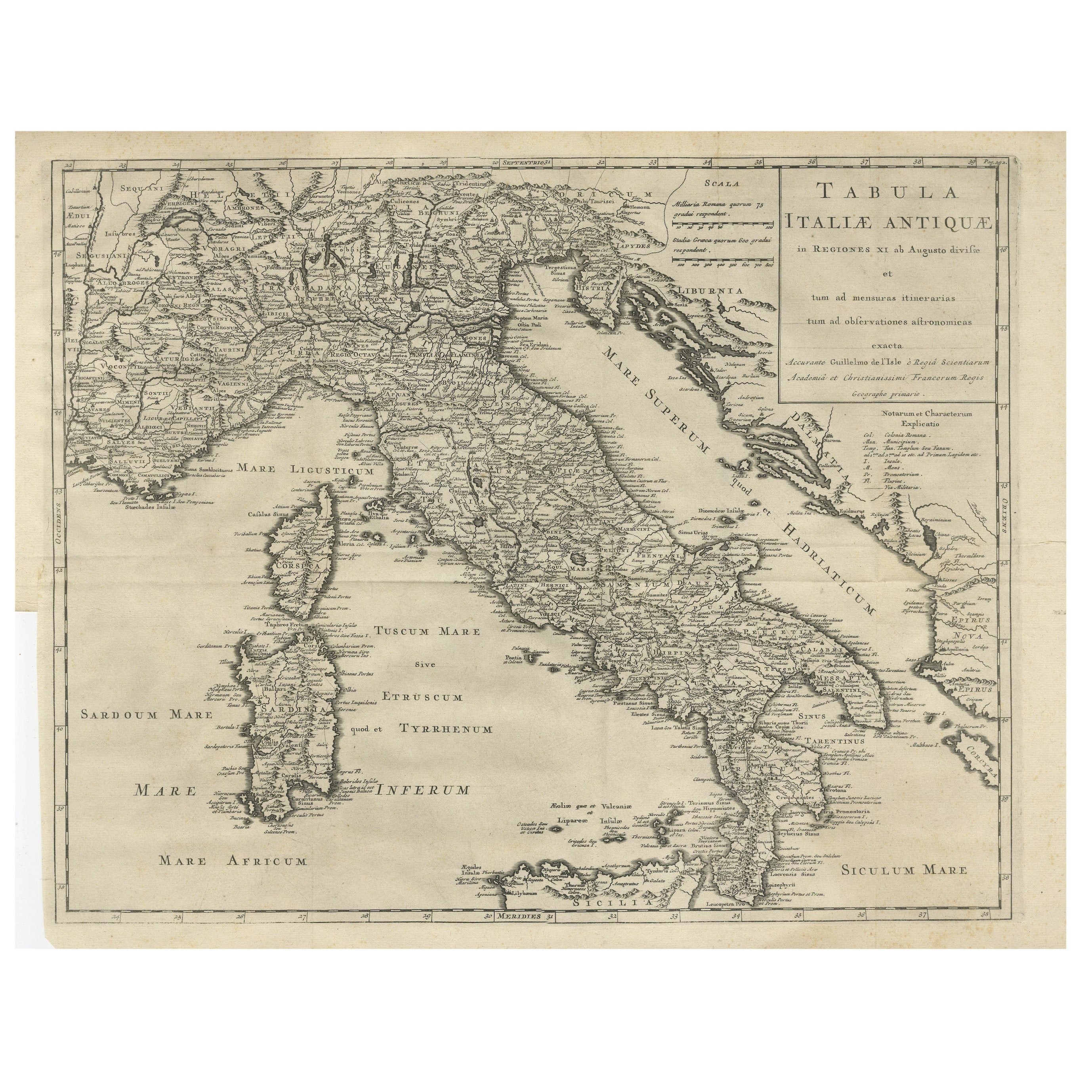
View AllAntique Engraved Map of Italy in Roman Times, ca.1730
Located in Langweer, NL
Plain engr. map of Italy according to the division of Emperor Augustus by G. Delisle.
Title: "Tabula Italiae Antiquae In Regiones XI Ab Augusto Divisae Et Tum Ad Mensuras Itinerari...
Category
Antique 1730s Maps
Materials
Paper
$642 Sale Price
20% Off
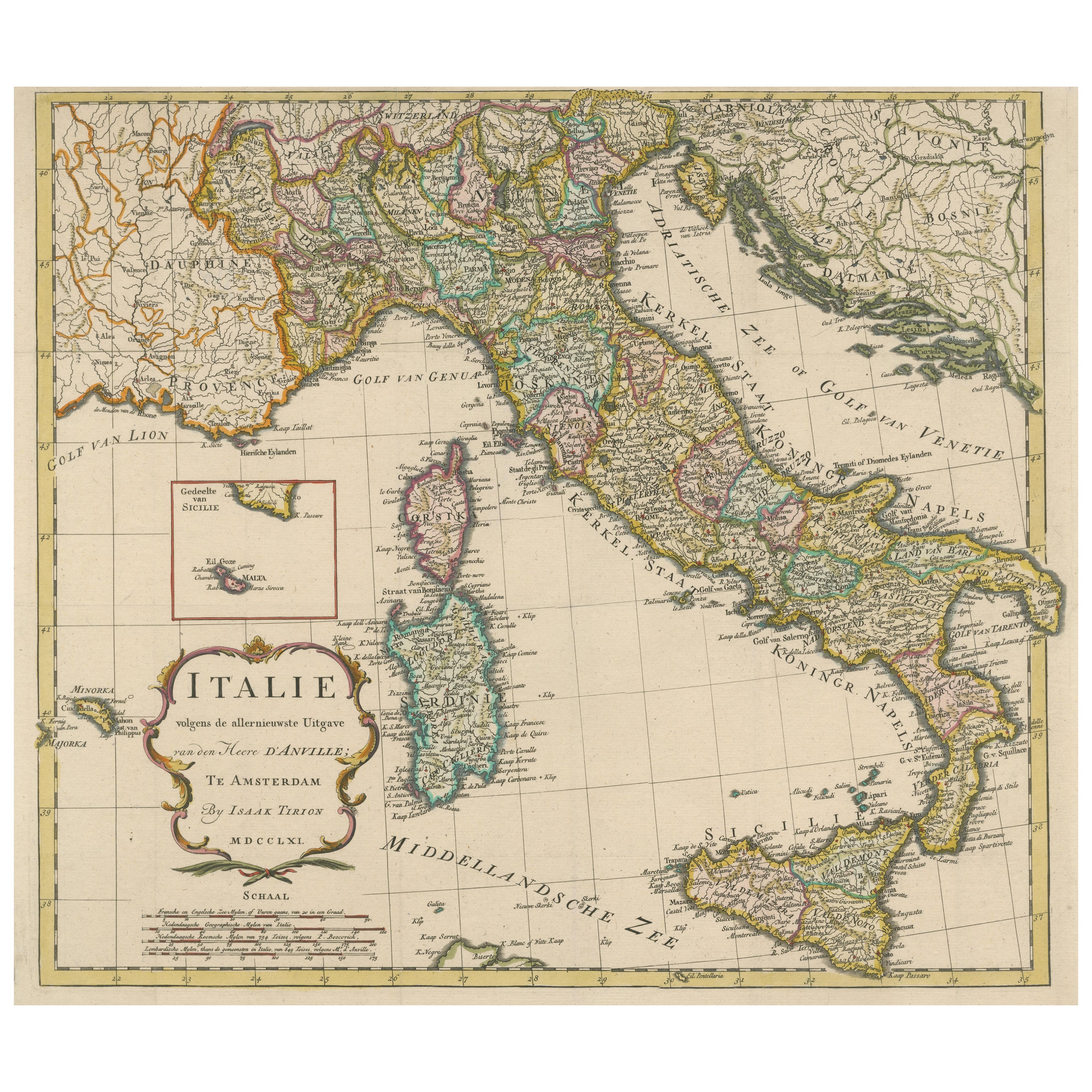
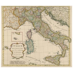
Detailed Antique Map of Italy and surrounding Islands
Located in Langweer, NL
Antique map titled 'Italie volgens de allernieuwste Uitgave van den Heere d'Anville'. Very detailed antique map, based on D'Anville's important map of It...
Category
Antique Mid-18th Century Maps
Materials
Paper
$586 Sale Price
20% Off
Antique Map of Italy by Keizer & de Lat, 1788
Located in Langweer, NL
Antique map titled 'Kaart van Italie (..)'. Uncommon original antique map of Italy. This map originates from 'Nieuwe Natuur- Geschied- en Handelk...
Category
Antique Late 18th Century Maps
Materials
Paper

$309 Sale Price
25% Off
Antique Map of Italy, Showing Corsica, Sardinia, Croatia, Malta and More, C.1740
Located in Langweer, NL
Antique map titled 'Nieuwe Kaart van Italie na de Nieuwste waarnemingen van de l'Isle en andere.'
Attractive detailed map showing Italy as well as Corsica, Sardinia, Minorca, Croat...
Category
Antique 18th Century Maps
Materials
Paper

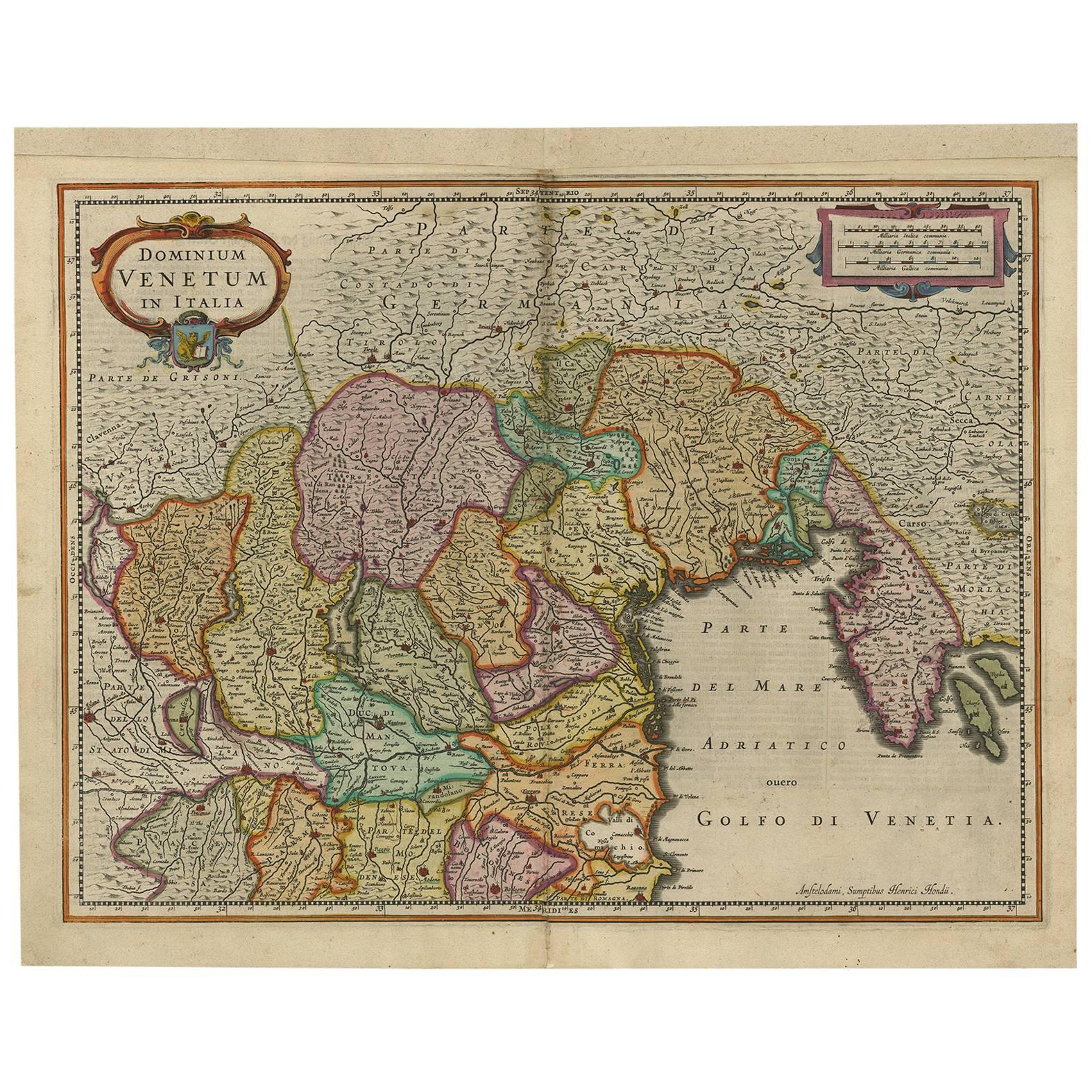
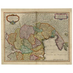
Antique Map of the Area Around Venice in Italy by H. Hondius, circa 1606
By Gerard Mercator, Jodocus Hondius
Located in Langweer, NL
Attractive and early map of the area around Venice, Italy. With South-Tirol in the North, areas of Krain (Slovenia), Croatia, Ferrara, Modena and Piacenza. In the east with areas aro...
Category
Antique Early 17th Century Dutch Maps
Materials
Paper
$656 Sale Price
20% Off
Antique Map of Italy, Corsica, Sardinia and Sicily, ca.1780
Located in Langweer, NL
Description: Antique map titled 'L'Italie.'
Map of Italy, Corsica, Sardinia and Sicily. Highly detailed, showing towns, rivers, some topographical features and political boundari...
Category
Antique 1780s Maps
Materials
Paper

$302 Sale Price
20% Off
You May Also Like
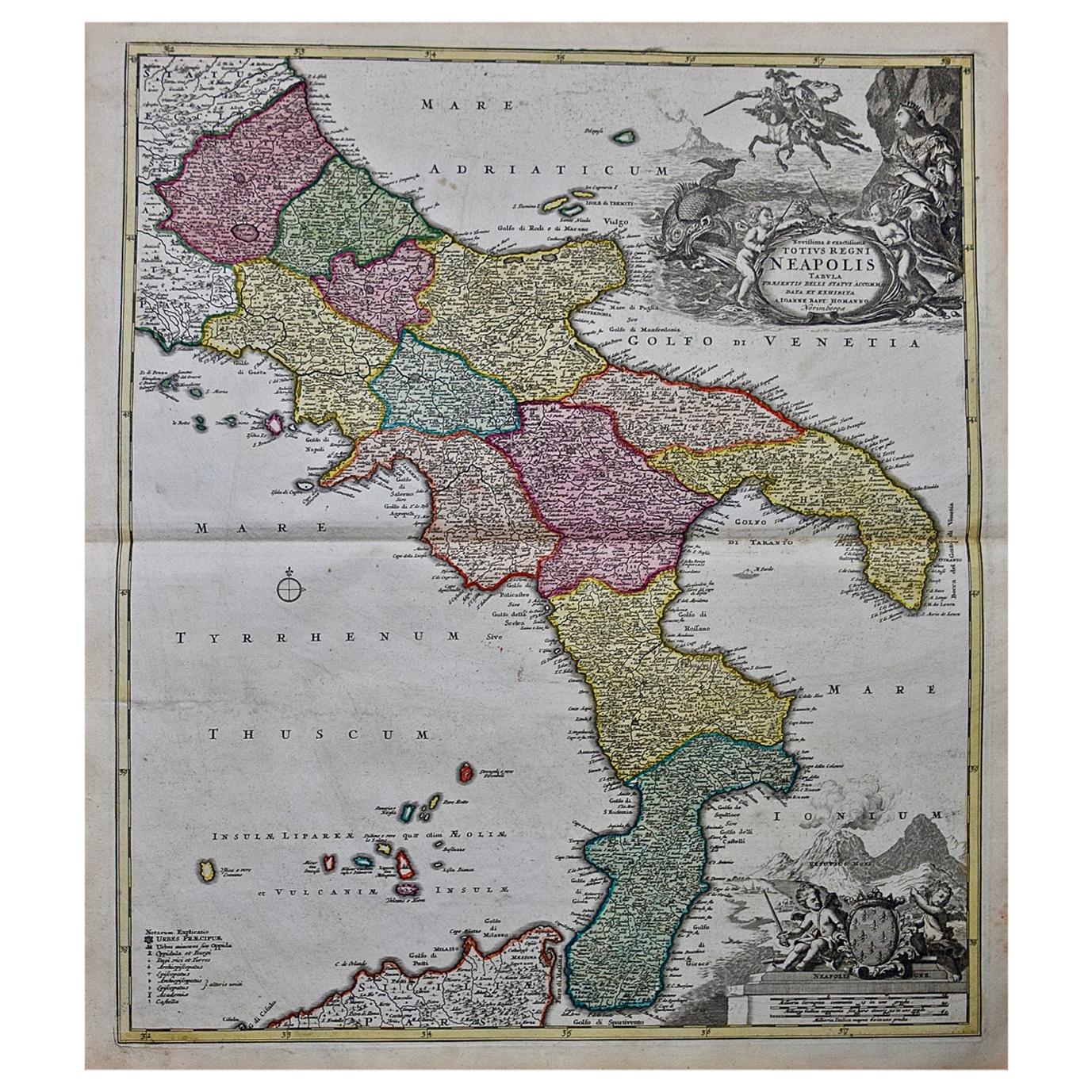
The Kingdom of Naples and Southern Italy: A Hand-Colored 18th Century Homann Map
By Johann Baptist Homann
Located in Alamo, CA
"Novissima & exactissimus Totius Regni Neapolis Tabula Presentis Belli Satui Accommo Data" is a hand colored map of southern Italy and the ancient Kingdom of Naples created by Johann...
Category
Antique Early 18th Century German Maps
Materials
Paper

1562 Map of Toscana Nuova Tavola by Girolamo Ruscelli
Located in Chapel Hill, NC
A 1562 map of Toscana Nuova Tavola by Girolamo Ruscelli. Tuscany is the heart of Italy & birthplace of the Italian language. Early hand-coloring. Copper plate engraving. Interestingl...
Category
Antique 16th Century Italian Renaissance Maps
Materials
Paper
Naples and S. Italy: A Large 17th C. Hand-colored Map by Sanson and Jaillot
By Nicholas Sanson d'Abbeville
Located in Alamo, CA
This large hand-colored map entitled "Le Royaume de Naples Divisé en Douze Provinces. sur les Memoires les plus Nouveaux. Par le Sr. Sanson Presenté" was originally created by Nicholas Sanson d'Abbeville and published by Hubert Jaillot in "Atlas Nouveau" in Paris in 1692. It depicts central and southern Italy, as well as Corfu, Albania, Mediterranean Sea and the Adriatic Sea. Naples, Sorrento, the Isle of Capri, Rome in the upper left corner of the map, as well as many other landmarks.
This striking original hand-colored map of Italy is printed on antique hand-made laid, chain-linked paper with wide margins. The sheet measures 20" high and 24.88" wide. There is one spot on the left, it is otherwise in very good to excellent condition.
Nicholas Sanson d'Abbeville (1600-1667) was one of the greatest French cartographather of French cartography. Sanson opened his first printing business in Paris in 1638. The king recognized his skill and knowledge and made him the official geographer to the court. He eventually served two kings in this capacity. Sanson was succeeded by his sons and son...
Category
1690s Landscape Prints
Materials
Engraving
Italy, Sicily, Sardinia, Corsica and Dalmatian Coast: A 17th Century Dutch Map
By Theodorus Danckerts
Located in Alamo, CA
This hand colored 17th century Dutch map entitled "Novissima et Accuratissima totius Italiae Corsicae et Sardiniae Descriptio" by Theodore Danckerts depicts the Italian Peninsula in ...
Category
Antique Late 17th Century Dutch Maps
Materials
Paper

Large Original Antique Map of Italy. John Dower, 1861
Located in St Annes, Lancashire
Great map of Italy
Lithograph engraving by John Dower
Original colour
Published, 1861
Unframed
Good condition / repair to top right corner seen in last image
Category
Antique 1860s English Victorian Maps
Materials
Paper

1571-1638 Willem Blaeu map entitled, "Ilcadorino, " Hand Colored Ric0009
Located in Norton, MA
Willem Blaeu map entitled,
"Ilcadorino,".
Hand colored.
Description: large, unusual, and nice antique copper engraved map of Ilcadorino, by Willem BL...
Category
Antique 16th Century Dutch Maps
Materials
Paper

More Ways To Browse
17th Century Dutch Wood Frames
Vintage Scandanavian Chairs
19th Century Red Glass
Antique French Console Table Tables
Silver Bowl Large
Antique French Silk
Down Couch
Used Lighter Art
Blue Edge Glass
Mahogany 1950s Furniture
Solid Mahogany Table
Dessert Glasses
Geometric Glass Table
Mid Century Pin
6x10 Rug
Studded Furniture
Styles Of Antique Desks
Black And White Coffee Table