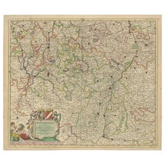
Items Similar to Large 1695 Hand-Colored Engraved Map of Gascony (Gascogna), France

Want more images or videos?
Request additional images or videos from the seller
1 of 10
Large 1695 Hand-Colored Engraved Map of Gascony (Gascogna), France
$2,156.66
$2,695.8220% Off
£1,605.49
£2,006.8720% Off
€1,800
€2,25020% Off
CA$2,954.08
CA$3,692.6020% Off
A$3,285.59
A$4,106.9820% Off
CHF 1,715.63
CHF 2,144.5420% Off
MX$39,982.08
MX$49,977.5920% Off
NOK 21,911.22
NOK 27,389.0220% Off
SEK 20,548.86
SEK 25,686.0720% Off
DKK 13,702.77
DKK 17,128.4620% Off
Shipping
Retrieving quote...The 1stDibs Promise:
Authenticity Guarantee,
Money-Back Guarantee,
24-Hour Cancellation
About the Item
This map, created by Giacomo Cantelli da Vignola in 1695, represents the "General Government of Guyenne and Gascony" in southwest France. Cantelli da Vignola was a renowned Italian cartographer who served the Duke of Modena. The map is dedicated to Cardinal Barberini, an influential figure in the Catholic Church.
- Gascony A historical region in southwestern France, known for its distinct culture and language.
- Guyenne: A significant province located northeast of Gascony.
- Bordeaux: A major city and port in the region, situated near the Garonne River, historically important for trade, especially in wine.
- Bay of Biscay and the Atlantic Coast: The map highlights key coastal features, such as the Isola d'Oleron and Pertuis de Maumusson.
The map focuses on important geographical, political, and coastal regions, featuring cities, rivers, mountains, and key landmarks in rich detail and color.
Upper Left Cartouche Translation and Description:
The upper left cartouche, ornately decorated with Baroque elements such as scrolls and floral details, includes an eagle emblem. It reads:
"Il Governo di Guienna e di Guascogna"
(The Government of Guyenne and Gascony)
Dedicated to the Most Illustrious and Reverend Monsignor Marcello Severoli
Referendario dell'Alma e della Sagrada Signatura, Prelato della Sacra Congregazione del Buon Governo, Avvocato Concistoriale e del Popolo Romano, Auditor Ordinario della Reverend Fabrica di San Pietro e Rotario della Signatura di Giustizia e di Grazia
(Referendary of the Holy and Sacred Signatura, Prelate of the Sacred Congregation of Good Governance, Consistorial Lawyer for the Roman People, Auditor of St Peter's Sacred Factory, and Judge of the Signatura of Justice and Grace)
This dedication is made to Marcello Severoli, a high-ranking church official with numerous titles associated with the governance of Rome and its legal institutions. The decorative style of the cartouche, featuring an eagle and ornate elements, reflects the significance of both the region of Gascony and the distinguished individual to whom it is dedicated.
Lower Cartouche Translation and Description:
The lower cartouche, positioned at the bottom of the map, follows a Baroque aesthetic with scrolls and ribbons. It reads:
"Governo Generale della Vienna e della Gvascogna"
(General Government of Guyenne and Gascony)
Delineato sulle piu precise regole geografiche da Giacomo Cantelli da Vignola, geographer of the Duke of Modena
(Drawn according to the most precise geographical rules by Giacomo Cantelli da Vignola, Geographer for the Duke of Modena)
E dedicato a Sua Eminenza Reverendissima Signor Cardinale Barberini
(Dedicated to His Eminence, the Most Reverend Cardinal Barberini)
Anno 1695
This cartouche provides information about the mapmaker, Giacomo Cantelli da Vignola, who was in the service of the Duke of Modena. It is dedicated to Cardinal Barberini, a notable figure in the Catholic Church and a member of the influential Barberini family. The mention of precise geographical rules reflects the importance placed on accuracy and detail in mapmaking during this period.
Both cartouches emphasize the map's subject, while highlighting the individuals to whom it was dedicated. This underscores the intersection of geography, politics, and patronage in 17th-century cartography, with the lavish decoration symbolizing the prominence of both the depicted region and the notable figures involved.
- Dimensions:Height: 33.86 in (86 cm)Width: 24.02 in (61 cm)Depth: 0 in (0.02 mm)
- Materials and Techniques:Paper,Engraved
- Period:1690-1699
- Date of Manufacture:1695
- Condition:Condition: very good, given age. Flattened horizontal fold as issued. General age-related toning and/or occasional minor defects from handling. Very strong paper. Please study scan carefully.
- Seller Location:Langweer, NL
- Reference Number:Seller: BG-13732-71stDibs: LU3054341725722
About the Seller
5.0
Recognized Seller
These prestigious sellers are industry leaders and represent the highest echelon for item quality and design.
Platinum Seller
Premium sellers with a 4.7+ rating and 24-hour response times
Established in 2009
1stDibs seller since 2017
2,510 sales on 1stDibs
Typical response time: <1 hour
- ShippingRetrieving quote...Shipping from: Langweer, Netherlands
- Return Policy
Authenticity Guarantee
In the unlikely event there’s an issue with an item’s authenticity, contact us within 1 year for a full refund. DetailsMoney-Back Guarantee
If your item is not as described, is damaged in transit, or does not arrive, contact us within 7 days for a full refund. Details24-Hour Cancellation
You have a 24-hour grace period in which to reconsider your purchase, with no questions asked.Vetted Professional Sellers
Our world-class sellers must adhere to strict standards for service and quality, maintaining the integrity of our listings.Price-Match Guarantee
If you find that a seller listed the same item for a lower price elsewhere, we’ll match it.Trusted Global Delivery
Our best-in-class carrier network provides specialized shipping options worldwide, including custom delivery.More From This Seller
View AllAntique Handcolored Map of the Dutch Province Groningen, Incl. Emden, Ca.1680
Located in Langweer, NL
Antique print, titled: 'Groningae et Omlandiae Dominium vulgo de Pronvicie van Stadt en Lande …'
A map of the Dutch province Groningen. A small part of Germany is also shown (Emd...
Category
Antique 1680s Maps
Materials
Paper
$910 Sale Price
20% Off
Antique Map of Lotharingia (Lorraine) by Danckerts, c. 1700 – Hand-Colored
Located in Langweer, NL
Antique Map of Lotharingia (Lorraine) by Theodorus Danckerts circa 1700 Hand-Colored
This beautifully detailed antique map of Lotharingia, now the Lorraine region in northeastern ...
Category
Antique Early 1700s Maps
Materials
Paper
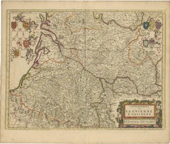
Gascogne and Guyenne Map - Hand-Colored 17th-Century Engraving by De Wit, c.1688
Located in Langweer, NL
Title: Gascogne and Guyenne Map - Hand-Colored 17th-Century Engraving by Frederik De Wit c. 1688
Description: This remarkable map, "Gouvernement de la Guyenne & Gascogne," captures ...
Category
Antique 1680s Maps
Materials
Paper
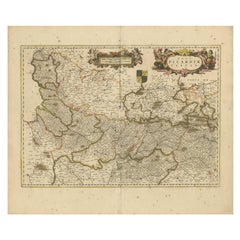
Picardy Map - Hand-Colored 17th-Century Engraving by Frederik De Wit c. 1688
Located in Langweer, NL
Title: Picardy Map - Hand-Colored 17th-Century Engraving by Frederik De Wit c. 1688
Description: This beautifully detailed map, "Nova Picardiae Tabula," captures the Picardy region ...
Category
Antique 1680s Maps
Materials
Paper
Old Original Handcoloured Map of the Former Province of Perche, France, ca.1640
Located in Langweer, NL
Antique map titled 'Perchensis Comitatus - La Perche compte'.
Old map of the former province of Perche, France. Until the French Revolution, Perche was bounded by four ancient te...
Category
Antique 1640s Maps
Materials
Paper
$690 Sale Price
20% Off
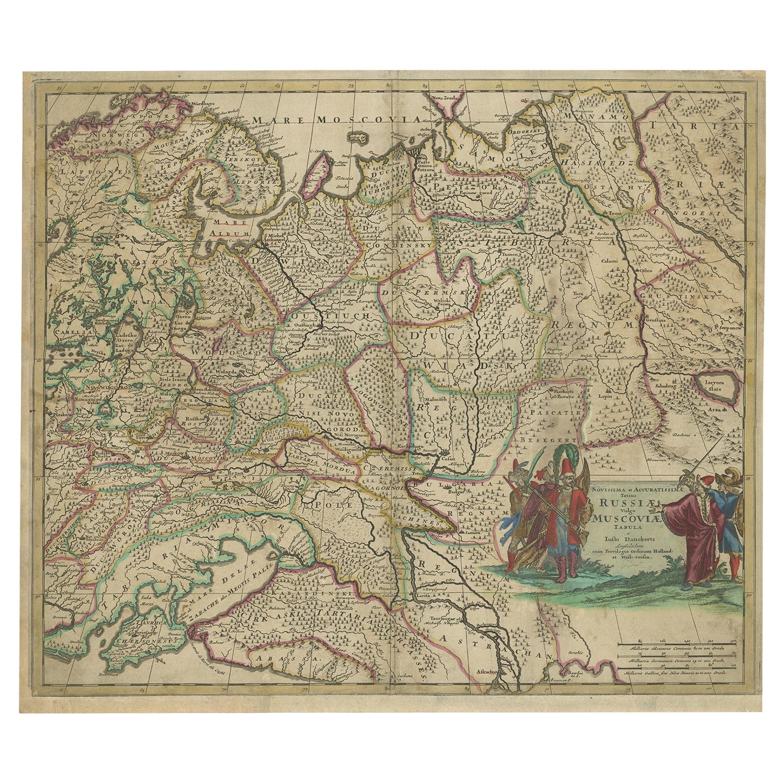
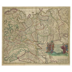
Antique Hand-Colored Map of Western Russia and Ukraine, c.1680
Located in Langweer, NL
Description: Antique map titled 'Novissima et Accuratissima Totius Russiae vulgo Muscoviae Tabula'.
Antique map of Western Russia and Ukraine, published by Justus Danckerts. The ma...
Category
Antique 1680s Maps
Materials
Paper
$718 Sale Price
20% Off
You May Also Like
17th Century Hand-Colored Map of a Region in West Germany by Janssonius
By Johannes Janssonius
Located in Alamo, CA
This attractive highly detailed 17th century original hand-colored map is entitled "Archiepiscopatus Maghdeburgensis et Anhaltinus Ducatus cum terris adjacentibus". It was published ...
Category
Antique Mid-17th Century Dutch Maps
Materials
Paper

17th Century Hand Colored Map of the Liege Region in Belgium by Visscher
By Nicolaes Visscher II
Located in Alamo, CA
An original 17th century map entitled "Leodiensis Episcopatus in omnes Subjacentes Provincias distincté divisusVisscher, Leodiensis Episcopatus" by Nicolaes Visscher II, published in Amsterdam in 1688. The map is centered on Liege, Belgium, includes the area between Antwerp, Turnhout, Roermond, Cologne, Trier and Dinant.
This attractive map is presented in a cream-colored mat measuring 30" wide x 27.5" high. There is a central fold, as issued. There is minimal spotting in the upper margin and a tiny spot in the right lower margin, which are under the mat. The map is otherwise in excellent condition.
The Visscher family were one of the great cartographic families of the 17th century. Begun by Claes Jansz Visscher...
Category
Antique Late 17th Century Dutch Maps
Materials
Paper

1771 Bonne Map of Poitou, Touraine and Anjou, France, Ric.a015
Located in Norton, MA
1771 Bonne Map of Poitou,
Touraine and Anjou, France
Ric.a015
1771 Bonne map of Potiou, Touraine and Anjou entitled "Carte des Gouvernements D'Anjou et du Saumurois, de la Touraine, du Poitou,du Pays d'aunis, Saintonge?Angoumois,"
Carte des gouvernements d'Anjou et du Saumurois, de la Touraine, du Poitou, du Pays d'Aunis, Saintonge-Angoumois. Projettee et assujettie au ciel par M. Bonne, Hyd. du Roi. A Paris, Chez Lattre, rue St. Jacques a la Ville de Bord(ea)ux. Avec priv. du Roi. 1771. Arrivet inv. & sculp., Atlas moderne ou collection de cartes sur toutes...
Category
Antique 17th Century Unknown Maps
Materials
Paper

The Normandy Region of France: A 17th C. Hand-colored Map by Sanson and Jaillot
By Nicolas Sanson
Located in Alamo, CA
This large hand-colored map entitled "Le Duché et Gouvernement de Normandie divisée en Haute et Basse Normandie en divers Pays; et par evêchez, avec le Gouvernement General du Havre ...
Category
Antique 1690s French Maps
Materials
Paper

18th Century Hand-Colored Homann Map of Germany, Including Frankfurt and Berlin
By Johann Baptist Homann
Located in Alamo, CA
An 18th century hand-colored map entitled "Tabula Marchionatus Brandenburgici et Ducatus Pomeraniae quae sunt Pars Septentrionalis Circuli Saxoniae Superioris" by Johann Baptist Homa...
Category
Antique Early 18th Century German Maps
Materials
Paper

Prussia, Poland, N. Germany, Etc: A Hand-colored 17th Century Map by Janssonius
By Johannes Janssonius
Located in Alamo, CA
This is an attractive hand-colored copperplate engraved 17th century map of Prussia entitled "Prussia Accurate Descripta a Gasparo Henneberg Erlichensi", published in Amsterdam by Joannes Janssonius in 1664. This very detailed map from the golden age of Dutch cartography includes present-day Poland, Latvia, Lithuania, Estonia and portions of Germany. This highly detailed map is embellished by three ornate pink, red, mint green and gold...
Category
Antique Mid-17th Century Dutch Maps
Materials
Paper
