Items Similar to Large Antique Map of Denmark by Bowles, c.1780


Want more images or videos?
Request additional images or videos from the seller
1 of 5
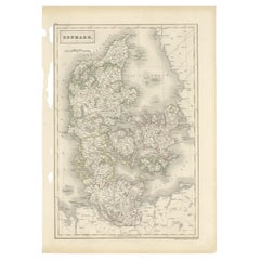
Large Antique Map of Denmark by Bowles, c.1780
$285.54
$356.9320% Off
£211.60
£264.5020% Off
€238.40
€29820% Off
CA$389.82
CA$487.2720% Off
A$433.66
A$542.0720% Off
CHF 227.33
CHF 284.1620% Off
MX$5,299.18
MX$6,623.9720% Off
NOK 2,894.74
NOK 3,618.4320% Off
SEK 2,725
SEK 3,406.2520% Off
DKK 1,815.16
DKK 2,268.9520% Off
Shipping
Retrieving quote...The 1stDibs Promise:
Authenticity Guarantee,
Money-Back Guarantee,
24-Hour Cancellation
About the Item
Antique map titled 'Bowles's new pocket map of the Kingdom of Denmark (..)' Large map of Denmark. Source unknown, to be determined.
Artists and Engravers: Made by 'Thomas & Carington Bowles' after 'J. Palairet'. Thomas Bowles, born around 1712, was map publisher and seller in London. The business was continued by John and Carrington Bowles and finally under the name Bowles and Carver until early 19th century. Thomas died in 1767.
Condition: Good, given age. Original/contemporary hand coloring. A few brown spots. Several vertical creases. Original middle fold as issued. General age-related toning and/or occasional minor defects from handling. Blank verso. Please study image carefully.
Date: c.1780
Overall size: 59.4 x 50.5 cm.
Image size: 53.4 x 47 cm.
We sell original antique maps to collectors, historians, educators and interior decorators all over the world. Our collection includes a wide range of authentic antique maps from the 16th to the 20th centuries. Buying and collecting antique maps is a tradition that goes back hundreds of years. Antique maps have proved a richly rewarding investment over the past decade, thanks to a growing appreciation of their unique historical appeal. Today the decorative qualities of antique maps are widely recognized by interior designers who appreciate their beauty and design flexibility. Depending on the individual map, presentation, and context, a rare or antique map can be modern, traditional, abstract, figurative, serious or whimsical. We offer a wide range of authentic antique maps for any budget.
- Creator:Thomas (Artist)
- Dimensions:Height: 19.89 in (50.5 cm)Width: 23.39 in (59.4 cm)Depth: 0 in (0.01 mm)
- Materials and Techniques:
- Period:
- Date of Manufacture:circa 1780
- Condition:
- Seller Location:Langweer, NL
- Reference Number:Seller: PC-589431stDibs: LU3054326159352
About the Seller
5.0
Recognized Seller
These prestigious sellers are industry leaders and represent the highest echelon for item quality and design.
Platinum Seller
Premium sellers with a 4.7+ rating and 24-hour response times
Established in 2009
1stDibs seller since 2017
2,494 sales on 1stDibs
Typical response time: 1 hour
- ShippingRetrieving quote...Shipping from: Langweer, Netherlands
- Return Policy
Authenticity Guarantee
In the unlikely event there’s an issue with an item’s authenticity, contact us within 1 year for a full refund. DetailsMoney-Back Guarantee
If your item is not as described, is damaged in transit, or does not arrive, contact us within 7 days for a full refund. Details24-Hour Cancellation
You have a 24-hour grace period in which to reconsider your purchase, with no questions asked.Vetted Professional Sellers
Our world-class sellers must adhere to strict standards for service and quality, maintaining the integrity of our listings.Price-Match Guarantee
If you find that a seller listed the same item for a lower price elsewhere, we’ll match it.Trusted Global Delivery
Our best-in-class carrier network provides specialized shipping options worldwide, including custom delivery.More From This Seller
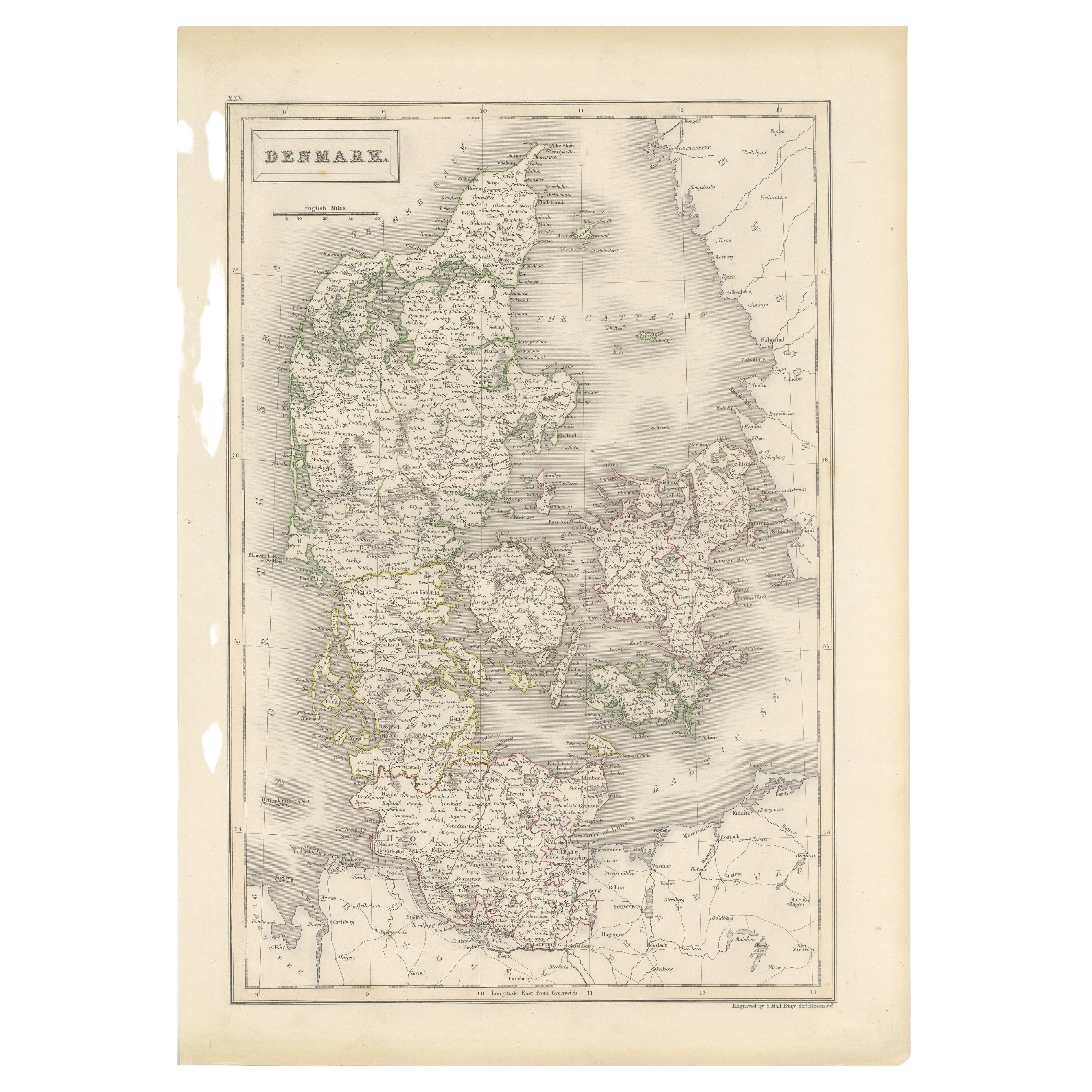
View AllAntique Map of Denmark by Hall, circa 1820
Located in Langweer, NL
Antique map titled 'Denmark'. A map of Denmark and the direct surroundings (northern Germany, Baltic Sea, Kattegatt and North Sea, south east Sweden). Sheet XXV from an unidentified ...
Category
Antique 19th Century Maps
Materials
Paper
$114 Sale Price
20% Off
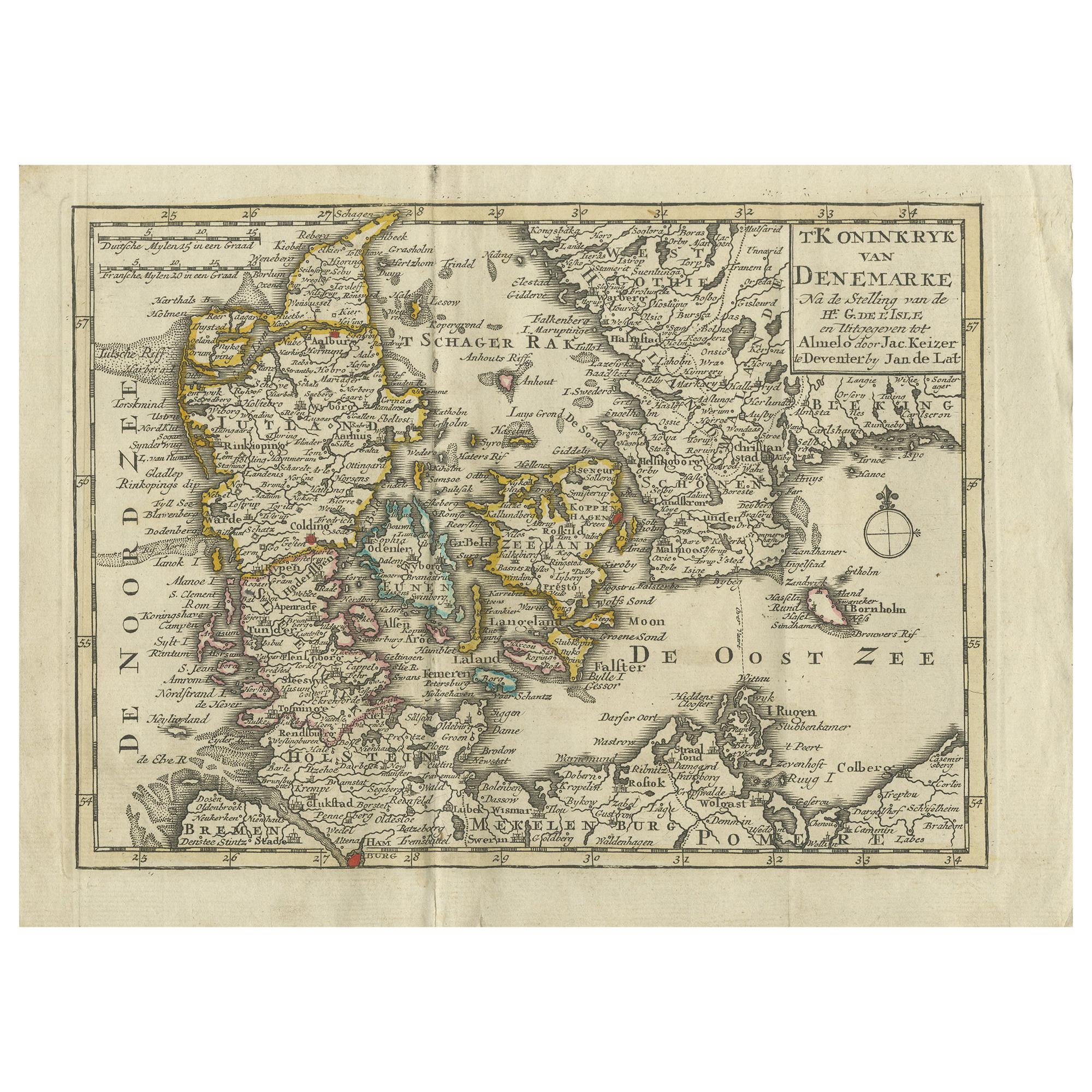
Antique Map of the Kingdom of Denmark by Keizer & de Lat, 1788
Located in Langweer, NL
Antique map titled 't Koninkryk van Denemarke'. Uncommon original antique map of the Kingdom of Denmark. This map originates from 'Nieuwe Natuur- Geschied- en Handelkundige Zak- en R...
Category
Antique Late 18th Century Maps
Materials
Paper
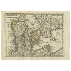
$335 Sale Price
20% Off
Original Hand-colored Antique Map of Denmark by S. Neele, 1790
Located in Langweer, NL
Antique very decorative engraving of Denmark engraved by S. Neele. Published in November 1790 by John Trusler. Tape on verso.
Category
Antique Late 18th Century Maps
Materials
Paper

$201 Sale Price
20% Off
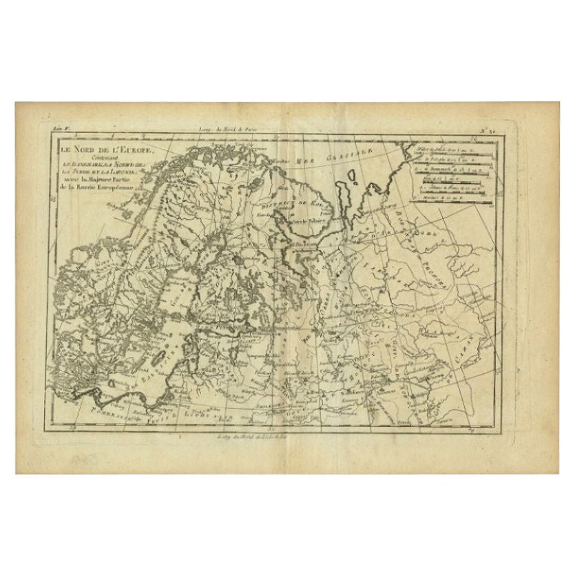
Antique Map of Northern Europe by Bonne, c.1780
Located in Langweer, NL
Antique map titled 'Le Nord de L'Europe, Contenant Le Danemark, La Norwege; La Suede et La Laponie avec la Majeure Partie de al Russie Europeenne.' Map of Northern Europe and Europea...
Category
Antique 18th Century Maps
Materials
Paper
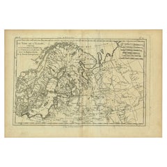
$129 Sale Price
20% Off
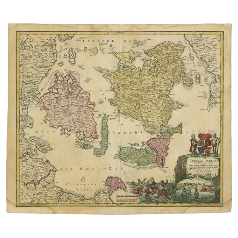
Antique Map of the Islands of Denmark by Homann Heirs, 1720
Located in Langweer, NL
Antique map titled 'Insula Danicae in Mari Balthico sitae (..).' - Map of the Danish islands situated in the Baltic Sea by J. B. Homann, (after J. Hübner's map of the region ) with g...
Category
Antique 18th Century Maps
Materials
Paper
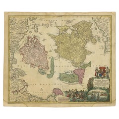
$333 Sale Price
20% Off
Denmark and Baltic Region – Antique Map by Guillaume de l’Isle, c.1730
By Covens & Mortier
Located in Langweer, NL
Denmark and Baltic Region – Antique Map by Guillaume de l’Isle, c.1730
This antique map titled Carte du Royaume de Danemark is a detailed 18th-century depiction of Denmark and its surrounding regions. Originally created by renowned French cartographer Guillaume de l’Isle, the map was published around 1730 by the Dutch publishers Covens...
Category
Antique Mid-18th Century Maps
Materials
Paper

$565 Sale Price
20% Off
You May Also Like
Hand-Colored 18th Century Homann Map of Denmark and Islands in the Baltic Sea
By Johann Baptist Homann
Located in Alamo, CA
An 18th century copper plate hand-colored map entitled "Insulae Danicae in Mari Balthico Sitae utpote Zeelandia, Fionia, Langelandia, Lalandia, Falstria, Fembria Mona" created by Joh...
Category
Antique Early 18th Century German Maps
Materials
Paper

Sweden & Adjacent Portions of Scandinavia: A Hand-Colored 18th C. Map by Homann
By Johann Baptist Homann
Located in Alamo, CA
This hand-colored map of Sweden and adjacent portions of Scandinavia entitled "Regni Sueciae in Omnes suas Subjacentes Provincias accurate divisi Tabula Generalis" was created by Joh...
Category
Antique 1720s German Maps
Materials
Paper

Original Antique Map of Sweden, Engraved by Barlow, 1806
Located in St Annes, Lancashire
Great map of Sweden
Copper-plate engraving by Barlow
Published by Brightly & Kinnersly, Bungay, Suffolk. 1806
Unframed.
Category
Antique Early 1800s English Maps
Materials
Paper

1790 Thomas Stackhouse Map, Entitled "Russia in Europe, " , Ric.a004
Located in Norton, MA
1790 Thomas Stackhouse map, entitled
"Russia in Europe"
Ric.a004
Stackhouse, Thomas
Russia in Europe [map]
London: T. Stackhouse, 1783. Map. Matted hand-colored copper engraving. Image size: 14.5 x 15.25 inches. Mat size: 22.75 x 23.75 inches. A beautiful example of this map of Eastern Europe...
Category
Antique 17th Century Unknown Maps
Materials
Paper

Scandinavia & Portions of Eastern Europe: 18th Century Hand-Colored Homann Map
By Johann Baptist Homann
Located in Alamo, CA
An early 18th century hand-colored copper-plate map entitled "Regni Sueciae in omnes suas Subjacentes Provincias accurate divisi Tabula Generalis" by Johann Baptist Homann (1663-1724...
Category
Antique Early 18th Century German Maps
Materials
Paper

Von Reilly Map of the Russian Empire, 1796
Located in Savannah, GA
A map of the Russian Empire in Europe by Von Reilly. Published in Vienna, 1796.
32 inches wide by 24 ½ inches tall
Category
Antique 1790s Austrian Prints
Materials
Glass, Wood, Paper

More Ways To Browse
Antique Large Bowl
Folded Bowl
Thomas Toner
Dior Bowl
Joan Blaeu
Antique Nautical Maps
Antique Portuguese Plates
New Zealand Map
Antique Railroad Collectibles
Blaeu World Map
Roman Empire Map
Antique Map Of Middle East
Caribbean Map
Antique Map Of Egypt
Antique Map Ortelius
Antique Farm Antiques Collectibles
Antique Galleon
Biblical Maps