Items Similar to Large Original Antique City Plan of Lucknow, India. Edward Weller, 1861

Want more images or videos?
Request additional images or videos from the seller
1 of 5
Large Original Antique City Plan of Lucknow, India. Edward Weller, 1861
$60
£45.87
€52.84
CA$84.08
A$93.87
CHF 49.18
MX$1,149.01
NOK 624.64
SEK 588.96
DKK 394.33
About the Item
Great city plan of Lucknow
Lithograph engraving by Edward Weller
Original colour
Published, 1861
Unframed
Good condition / slight corner loss bottom right shown in last image
- Dimensions:Height: 19 in (48.26 cm)Width: 13 in (33.02 cm)Depth: 0.07 in (1.78 mm)
- Style:Victorian (Of the Period)
- Materials and Techniques:Paper,Other
- Place of Origin:
- Period:
- Date of Manufacture:1861
- Condition:Wear consistent with age and use.
- Seller Location:St Annes, GB
- Reference Number:1stDibs: LU1836341083592
About the Seller
4.9
Platinum Seller
Premium sellers with a 4.7+ rating and 24-hour response times
1stDibs seller since 2016
3,116 sales on 1stDibs
Typical response time: 1 hour
Associations
International Confederation of Art and Antique Dealers' Associations
- ShippingRetrieving quote...Shipping from: St Annes, United Kingdom
- Return Policy
Authenticity Guarantee
In the unlikely event there’s an issue with an item’s authenticity, contact us within 1 year for a full refund. DetailsMoney-Back Guarantee
If your item is not as described, is damaged in transit, or does not arrive, contact us within 7 days for a full refund. Details24-Hour Cancellation
You have a 24-hour grace period in which to reconsider your purchase, with no questions asked.Vetted Professional Sellers
Our world-class sellers must adhere to strict standards for service and quality, maintaining the integrity of our listings.Price-Match Guarantee
If you find that a seller listed the same item for a lower price elsewhere, we’ll match it.Trusted Global Delivery
Our best-in-class carrier network provides specialized shipping options worldwide, including custom delivery.More From This Seller
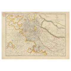
View AllOriginal Antique Map or City Plan of Rome, Italy. Circa 1835
Located in St Annes, Lancashire
Nice map of Rome
Drawn and engraved by J.Dower
Published by Orr & Smith. C.1835
Unframed.
Free shipping
Category
Antique 1830s English Maps
Materials
Paper

Original Antique English County Map, Cambridgeshire, J & C Walker, 1851
Located in St Annes, Lancashire
Great map of Cambridgeshire
Original colour
By J & C Walker
Published by Longman, Rees, Orme, Brown & Co. 1851
Unframed.
Category
Antique 1850s English Other Maps
Materials
Paper

Original Antique English County Map, Huntingdonshire, J & C Walker, 1851
Located in St Annes, Lancashire
Great map of Huntingdonshire
Original colour
By J & C Walker
Published by Longman, Rees, Orme, Brown & Co. 1851
Unframed.
Category
Antique 1850s English Other Maps
Materials
Paper

Original Antique Map or City Plan of Madrid, Spain. Circa 1835
Located in St Annes, Lancashire
Nice map of Madrid
Drawn and engraved by J.Dower
Published by Orr & Smith. C.1835
Unframed.
Free shipping
Category
Antique 1830s English Maps
Materials
Paper

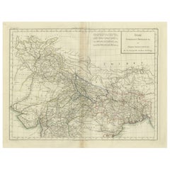
Original Antique Map of India by Dower, circa 1835
Located in St Annes, Lancashire
Nice map of India
Drawn and engraved by J.Dower
Published by Orr & Smith. C.1835
Unframed.
Free shipping
Category
Antique 1830s English Maps
Materials
Paper

Original Antique English County Map, Buckinghamshire, J & C Walker, 1851
Located in St Annes, Lancashire
Great map of Buckinghamshire
Original colour
By J & C Walker
Published by Longman, Rees, Orme, Brown & Co. 1851
Unframed.
Category
Antique 1850s English Other Maps
Materials
Paper

You May Also Like
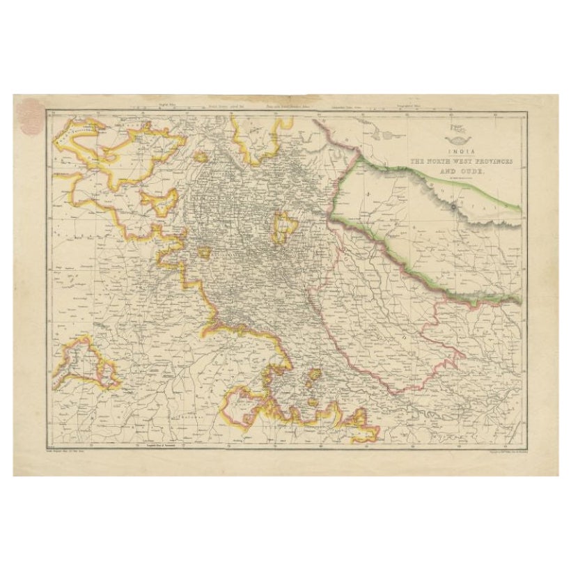
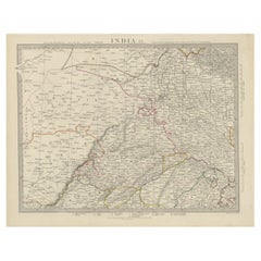
Antique Map of Northwestern India by Weller, 1857
Located in Langweer, NL
Antique map titled 'India, The North West Provinces and Oude'.Detailed map of the northwestern part of India, extending to the Himalaya Mountains. Shows part of Nepal including Dharm...
Category
Antique 19th Century Maps
Materials
Paper
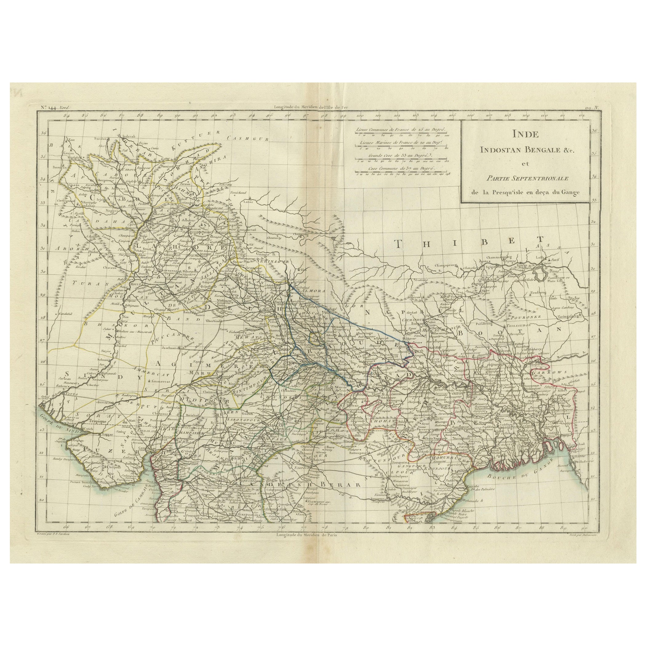
Antique Map of Northern India, Bengal, and Surrounding Regions by Tardieu, 1802
Located in Langweer, NL
This is an original antique map titled "Inde, Indostan Bengale &c. et Partie Septentrionale de la Presqu'isle en deça du Gange," depicting the northern part of the Indian subcontinen...
Category
Antique Early 1800s Maps
Materials
Paper
$415 Sale Price
20% Off
Antique Map of the Region of Delhi in India, 1833
Located in Langweer, NL
Antique map titled 'India IX'. Old steel engraved map of the region of Delhi, with great detail.
Artists and Engravers: Engraved by J. & C. Walker. Published under the superinten...
Category
Antique 19th Century Maps
Materials
Paper
$378 Sale Price
20% Off
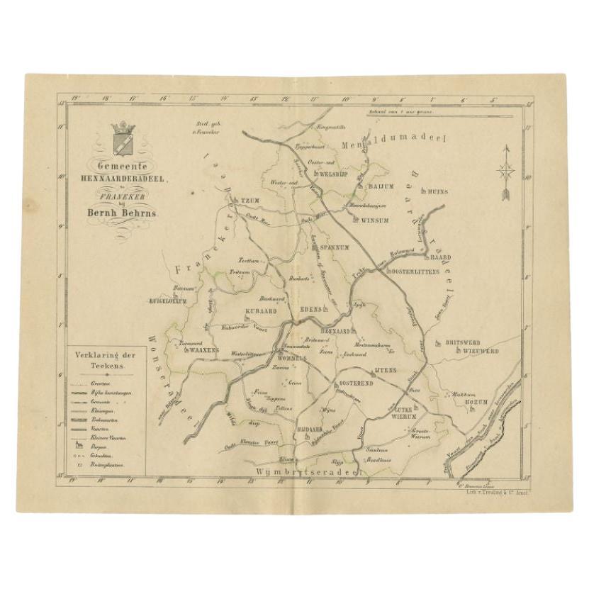
Antique Map of the Hennaarderadeel Township by Behrns, 1861
Located in Langweer, NL
Antique map titled 'Gemeente Hennaarderadeel'. Old map depicting the Hennaarderadeel township including cities and villages like Kubaard, Wommels, Hennaard, Oosterend, Wierum, Tzum, ...
Category
Antique 19th Century Maps
Materials
Paper
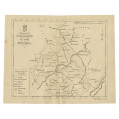
$84 Sale Price
20% Off
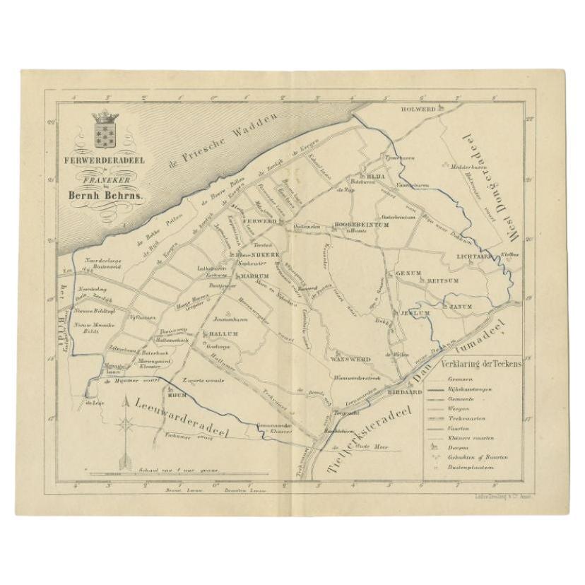
Antique Map of the Ferwerderadeel Township by Behrns, 1861
Located in Langweer, NL
Antique map titled 'Ferwerderadeel'. Old map depicting the Ferwerderadeel township including cities and villages like Ferwerd, Marrum, Hallum, Wanswerd and Hijum. This map orginates ...
Category
Antique 19th Century Maps
Materials
Paper
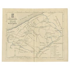
$84 Sale Price
20% Off
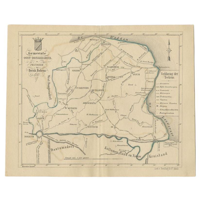
Antique Map of the Oost-Dongeradeel Township by Behrns, 1861
Located in Langweer, NL
Antique map titled 'Gemeente Oost-Dongeradeel'. Old map depicting the Oost-Dongeradeel township including cities and villages like Nijkerk, Morra, Anjum, Metslawier, Aalsum and Engwi...
Category
Antique 19th Century Maps
Materials
Paper
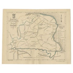
$84 Sale Price
20% Off
More Ways To Browse
India Engraving
Coffee Table Black Italian Modern
Christofle America
Iranian Silk Rug Carpet
Poul Moller
Tables With Inlaid Wood
World War Table
Antonio Jacobsen
Ariston Chairs
Coffee Tables Europe
Marble Top Dining Tables
Nordiska Argentina
Pink And Black Rug
Black Wooden Chair
Orrefors Embassy
Black Ebonized
Elios Chair
Panache Designs