Items Similar to Limburg Cityscape 1580: Historical Copper Engraving by Braun and Hogenberg
Want more images or videos?
Request additional images or videos from the seller
1 of 8
Limburg Cityscape 1580: Historical Copper Engraving by Braun and Hogenberg
$604.90
$756.1320% Off
£453.41
£566.7720% Off
€512
€64020% Off
CA$831.03
CA$1,038.7920% Off
A$927.77
A$1,159.7220% Off
CHF 486.14
CHF 607.6720% Off
MX$11,356.84
MX$14,196.0520% Off
NOK 6,173.97
NOK 7,717.4620% Off
SEK 5,821.27
SEK 7,276.5820% Off
DKK 3,897.53
DKK 4,871.9120% Off
Shipping
Retrieving quote...The 1stDibs Promise:
Authenticity Guarantee,
Money-Back Guarantee,
24-Hour Cancellation
About the Item
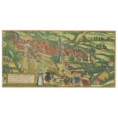
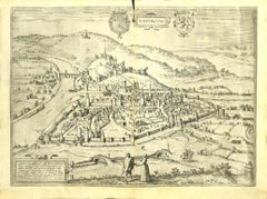
Title: Limburgum Oppidum Galliae Belgicae, vulgo Lympurch, gallicè, Lembor Dr.
Type: Print (Copper Engraving)
Circa 1580
Technique: Colored Copper Engraving
Medium: Handmade Paper
Subject: Cityscape of Limburg
Verso: Contains Latin text
Margins: Narrow
This map is a detailed and colorful illustration of the city of Limburg, known historically as Lympurch, as it appeared in the late 16th or early 17th century. The map is from Braun and Hogenberg's renowned atlas "Civitates Orbis Terrarum," which aimed to provide detailed and artistic representations of cities from around the world.
Description of the Map
1. **Cityscape**: The city is depicted with a high level of detail, showcasing its fortifications, churches, and various buildings. The city's layout is visible, with streets and structures intricately drawn.
2. **Surrounding Landscape**: The surrounding landscape includes rolling hills, fields, and forests, giving a sense of the topography around Limburg. Agricultural activities are depicted, with figures tending to livestock and working the land.
3. **Coats of Arms and Cartouches**: The map features ornate coats of arms and decorative cartouches, including a prominent one at the top center labeled "LYMPVRCH" and others with heraldic symbols.
4. **Figures and Activities**: In the foreground, figures are depicted engaging in various activities, such as farming and herding sheep. These elements add a lively and human touch to the map.
5. **Latin Inscriptions**: The map includes several Latin inscriptions that provide context and information about the city.
Translation of the Latin Inscriptions
1. **Title and Description**:
- "Limburgum oppidum Galliae Belgicae: ex vulgo Lympurch, gallice Lembro dict."
- **Translation**: "Limburg, a town of Belgic Gaul: commonly known as Lympurch, in French called Lembro."
2. **Main Cartouche (Left)**:
- "Limburgum oppidum Galliae Belgicae ex vulgo Lympurch, gallice Lembro dict. Urbem Gislebertus regis Henrici nepos condidisse fertur: ad eam accedunt rarioribus modis duae viae, propeque duobus R. P. cœnobiis insignitur, M. Didennis & S. c. quum S. Pauli. Quibus Castri Comites antiquissimae nobilitatis patria quae superiori Lemburgo non ignobilis dignitate nitescens..."
- **Translation**: "Limburg, a town of Belgic Gaul commonly called Lympurch, in French called Lembro. The town is said to have been founded by Gislebert, nephew of King Henry: it is approached by two rare routes, and is distinguished by two prominent monasteries, the monastery of St. Denis and that of St. Paul. The counts of the castle, who shine with ancient nobility, come from this country, which, being superior to Limburg, is not lacking in dignity..."
3. **Right Cartouche (Key to the Map)**:
- A numbered list correlates with locations on the map.
- **Translation**:
1. The New Great Church
2. The Old Castle
3. The Church of the Holy Cross
4. The St. Denis Monastery
5. The St. Paul Monastery
6. The Old Great Church
7. The Vineyard
8. The New City Hall
9. The Old City Hall
10. The Market Place
11. The Fish Market
12. The Town Square
13. The Little River Bridge
14. The Great River Bridge
15. The Outer Fields
16. The Fortified Wall
17. The South Gate
18. The North Gate
This map is a valuable historical artifact, providing insight into the geography, architecture, and daily life of Limburg during the time it was created. The attention to detail and artistic quality make it a notable example of early cartography.
- Dimensions:Height: 16.19 in (41.1 cm)Width: 20.08 in (51 cm)Depth: 0.01 in (0.2 mm)
- Materials and Techniques:Paper,Engraved
- Period:
- Date of Manufacture:circa 1580
- Condition:The engraving has narrow margins suggesting possible trimming. Fold in middle as issued. The hand-coloring enhance its visual appeal, depicting Limburg's urban and rural life vividly. Verso Latin text. Overall, it remains a well-preserved artifact.
- Seller Location:Langweer, NL
- Reference Number:Seller: BG-13526-11stDibs: LU3054340539322
About the Seller
5.0
Recognized Seller
These prestigious sellers are industry leaders and represent the highest echelon for item quality and design.
Platinum Seller
Premium sellers with a 4.7+ rating and 24-hour response times
Established in 2009
1stDibs seller since 2017
2,511 sales on 1stDibs
Typical response time: <1 hour
- ShippingRetrieving quote...Shipping from: Langweer, Netherlands
- Return Policy
Authenticity Guarantee
In the unlikely event there’s an issue with an item’s authenticity, contact us within 1 year for a full refund. DetailsMoney-Back Guarantee
If your item is not as described, is damaged in transit, or does not arrive, contact us within 7 days for a full refund. Details24-Hour Cancellation
You have a 24-hour grace period in which to reconsider your purchase, with no questions asked.Vetted Professional Sellers
Our world-class sellers must adhere to strict standards for service and quality, maintaining the integrity of our listings.Price-Match Guarantee
If you find that a seller listed the same item for a lower price elsewhere, we’ll match it.Trusted Global Delivery
Our best-in-class carrier network provides specialized shipping options worldwide, including custom delivery.More From This Seller
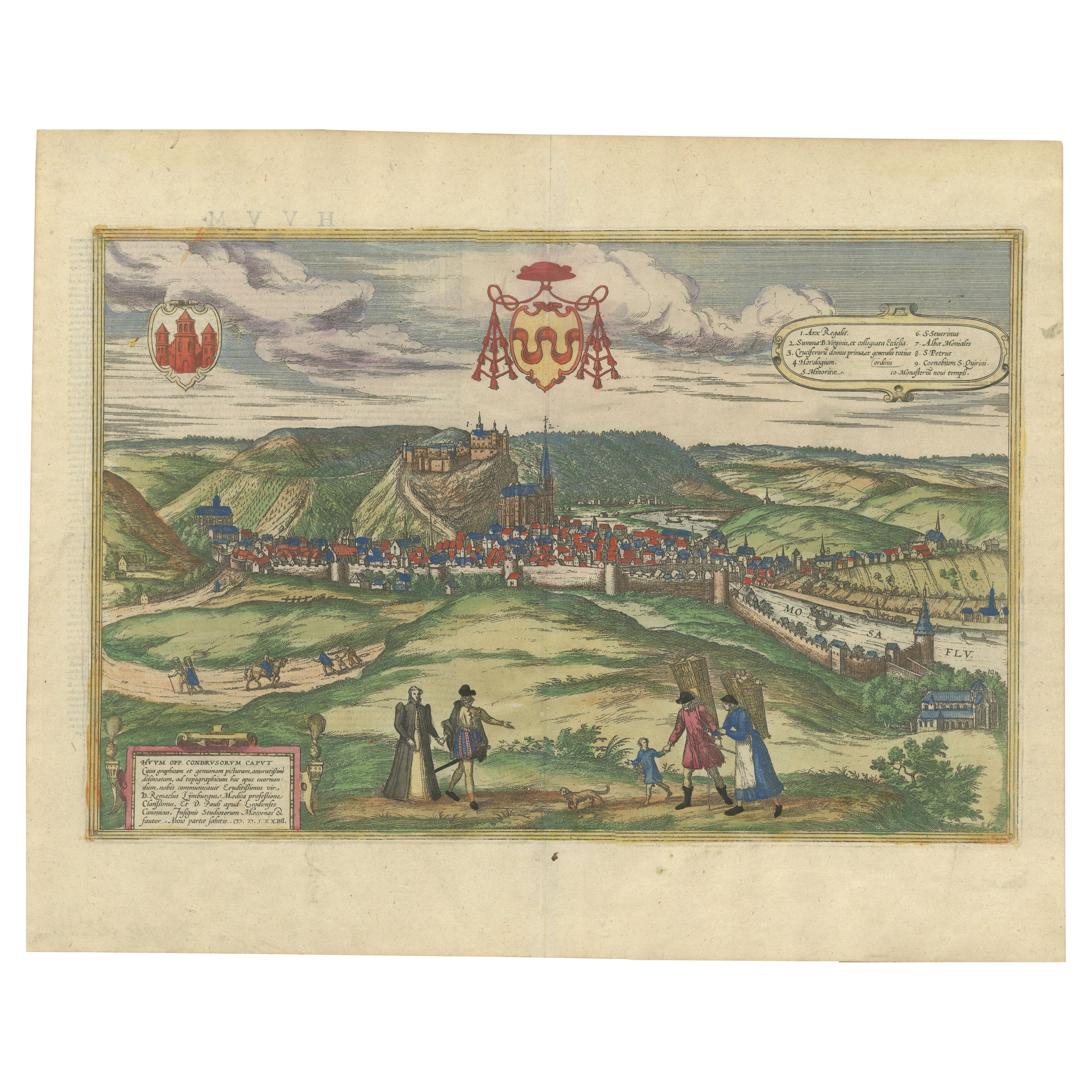
View AllHuy (Huum) Cityscape 1574: Historical Copper Engraving by Braun & Hogenberg
Located in Langweer, NL
Title: Huum opp. condrusorum caput (...) Anno partae salutis 1574.
**Type:** Print (Colored Copper Engraving)
**Year:** Circa 1580
**Technique:** Colored Copper Engraving
**Medium:...
Category
Antique 16th Century Maps
Materials
Paper
$604 Sale Price
20% Off
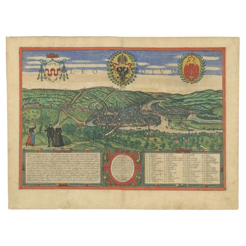
Antique Print of Liège / Luik in Belgium by Braun & Hogenberg, 1575
Located in Langweer, NL
Antique print titled 'Leodium'. View of Liège / Luik, Belgium with surrounding hills and the city wall. With text explaining the origins of Liège, a cartouche expressing thanks to th...
Category
Antique 16th Century Prints
Materials
Paper
$1,266 Sale Price
20% Off
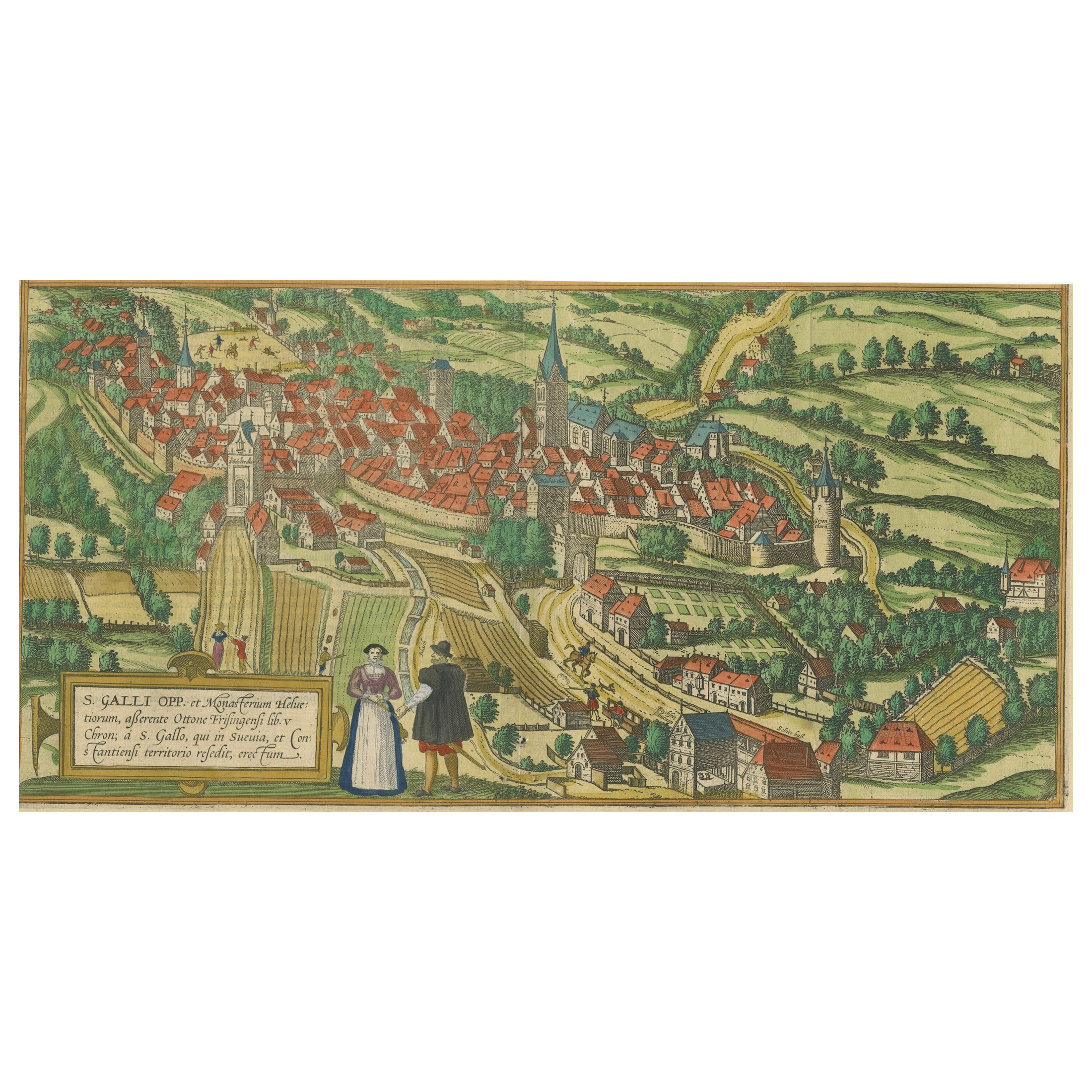
Engraving of St. Gallen and its Monastery, from Civitates Orbis Terrarum (1575)
Located in Langweer, NL
Description of the Engraving: Braun & Hogenberg’s "S. Galli Opp. et Monasterium Heluetiorum" from Civitates Orbis Terrarum (1575)
This is an original, hand-colored copper engraving ...
Category
Antique 16th Century Maps
Materials
Paper
$652 Sale Price
20% Off
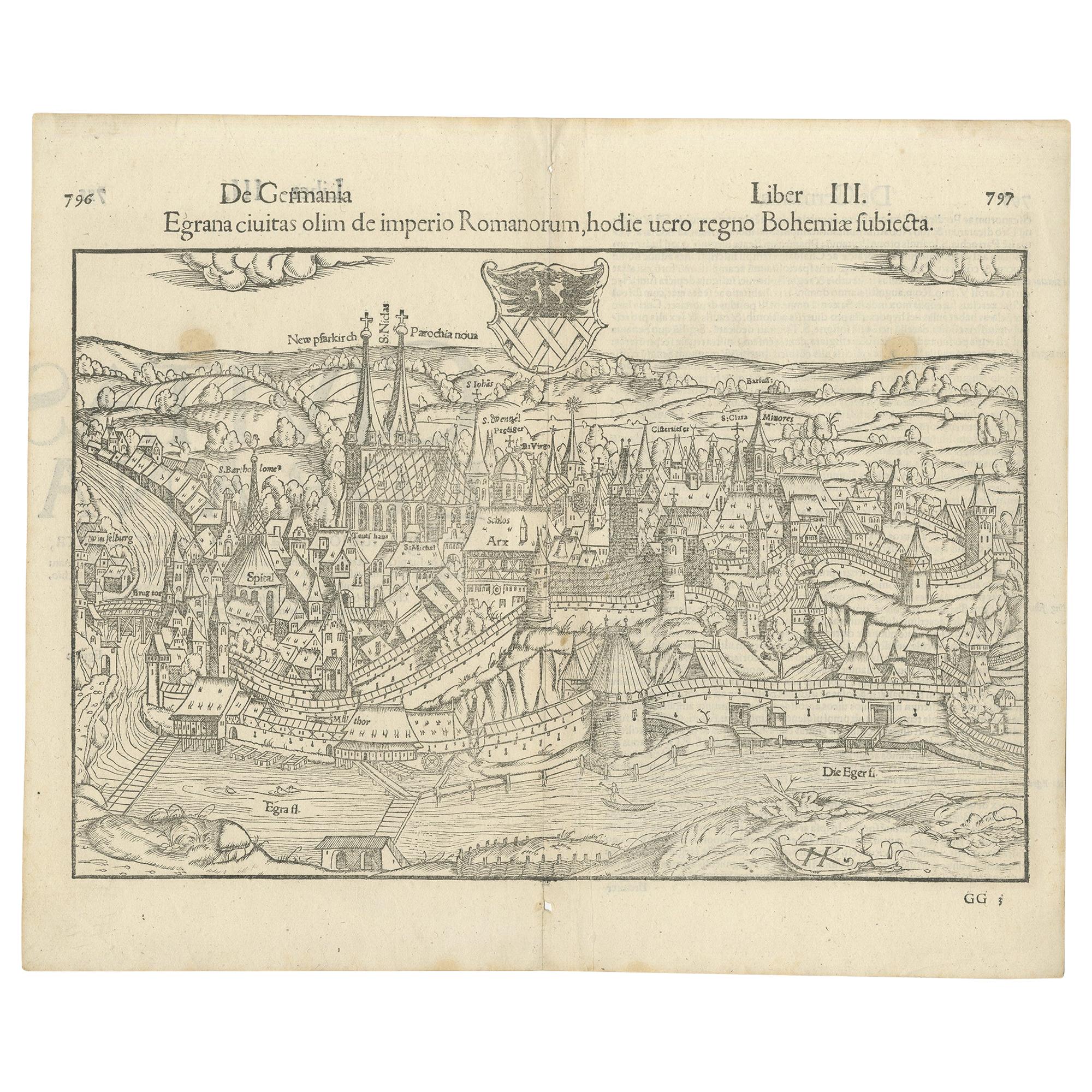
Antique Print with a View of the City of Eger 'Cheb' by Münster '1554'
Located in Langweer, NL
Antique print titled 'Egrana civitas olim de imperio Romanorum (..)'. Important early view of the walled town of Eger, or Cheb, in the Czech Republic, including the city's coat of ar...
Category
Antique 16th Century Prints
Materials
Paper
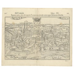
$378 Sale Price
20% Off
Antique Print of Büdingenin Germany by Braun & Hogenberg, 1617
Located in Langweer, NL
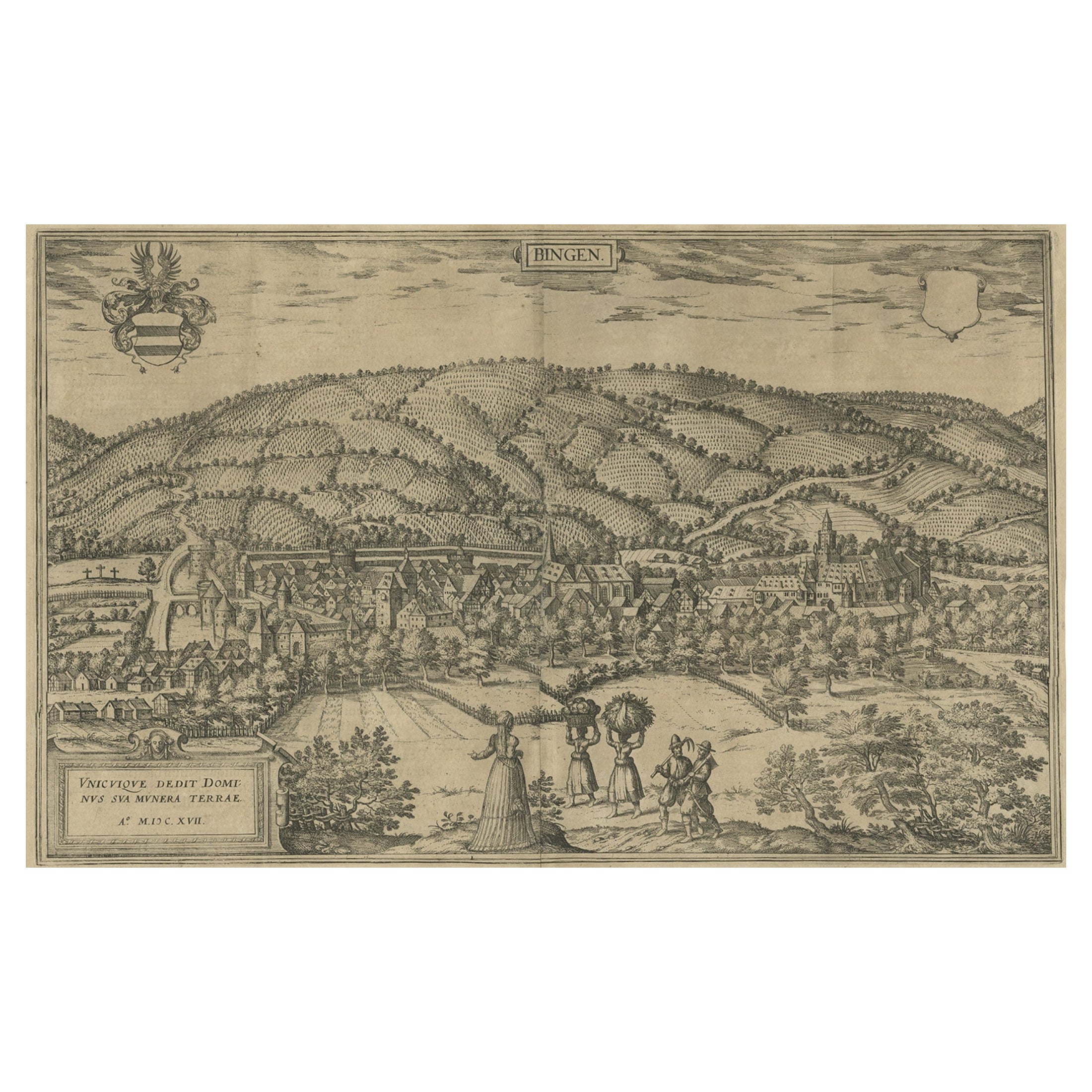
Antique map titled 'Bingen'. Bird's eye-view of Büdingen, Germany. The view shows a city surrounded by vineyards and well fortified with walls and moats. On the right is the castle w...
Category
Antique 17th Century Prints
Materials
Paper
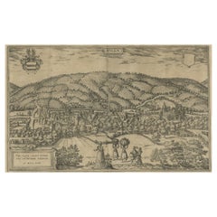
$274 Sale Price
20% Off
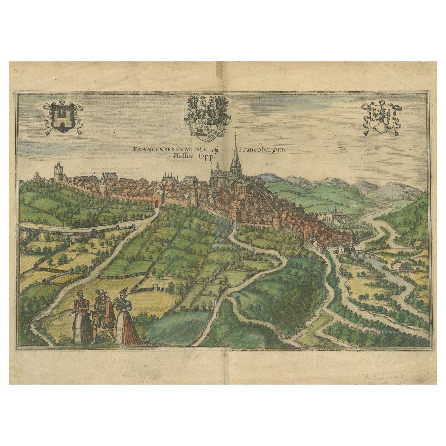
View of Frankenberg: Braun & Hogenberg's Historic Bird's-Eye Map, 1599
Located in Langweer, NL
The antique print titled 'Francenbergum, vel ut alij Francoburgum Hassiae Opp', published by Braun & Hogenberg around 1599, is a remarkable historical ...
Category
Antique 16th Century Prints
Materials
Paper
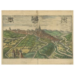
$472 Sale Price
20% Off
You May Also Like
View of Namur (Belgium) - Etching by G. Braun and F. Hogenberg - Late 1500
By Franz Hogenberg
Located in Roma, IT
This View of Namvrcvm (the ancient city of Namur, Belgium) is an original etching realized by George Braun and Franz Hogenberg, as part of the famous Series "Civitates Orbis Terrarum...
Category
16th Century Figurative Prints
Materials
Etching
Map of Nijmegen - Etching by G. Braun and F. Hogenberg - Late 16th Century
By Franz Hogenberg
Located in Roma, IT
This map of Noviomagvs is an original etching realized by Georg Braun and Franz Hogenberg as part of the famous series "Civitates Orbis Terrarum".
The state of preservation of the ...
Category
16th Century Figurative Prints
Materials
Etching

View of Middelburg - Etching by G. Braun and F. Hogenberg - Late 1500
By Franz Hogenberg
Located in Roma, IT
This map of Middelburg (ancient name: Middelbvrgvm) is an original etching realized by George Braun and Franz Hogenberg as part of the famous Series "Civitates Orbis Terrarum".
The ...
Category
16th Century Figurative Prints
Materials
Etching
View of Meissen, Germany: A 16th Century Hand-colored Map by Braun & Hogenberg
By Franz Hogenberg
Located in Alamo, CA
This is a 16th century original hand-colored copperplate engraved map of View of View of Meissen, Germany entitled "Misena Hermun Duvorum Urbs" by Georg Braun & Franz Hogenberg, from their famous city atlas "Civitates Orbis Terrarum", published in Cologne, Germany in 1575.
The map depicts a side view and bird's-eye view, looking across the Elbe River (labelled Albis Fluvius on the map; White River in Latin) from the northeast. In the foreground are three women in conversation on a hill above the city, along with a man and a woman in conversation by a road, all dressed in contemporary costumes of the upper class. A coat-of-arms is present in each upper corner. A great castle sits atop a hill in the background on the left. Meissen grew up around Albrechtsburg castle, built by Emperor Henry I around AD 929, and was granted a municipal charter at the end of the 12th century. From 1471 onwards, the castle complex was reconstructed as the residence of the Saxon electors on the northeast corner of the Domberg (Cathedral Hill). Meissen cathedral is a Gothic hall church begun c. 1270; in 1413 a bolt of lightning destroyed its west towers, which were replaced only in the 20th century. Meissen lies to the northwest of Dresden, Germany in Saxony. Meissen is famous for its Meissen porcelain and the Albrechtsburg castle
The following is an English translation of an excerpt from Braun's description of the city: "This city is surrounded by very many rivers, to the east flows the Elbe, to the south the Triebisch, to the west are the mountains, to the north the Meisse, after which the city is said to be named. The city is well-situated in its surroundings, the navigable rivers, the mountains and the healthy air. Around the city there is a good land to grow grain, fertile vineyards on the hillsides and without doubt the mountains are not without ore, for one mile away, up the Elbe, is Scharfenberg, where silver and lead ore are mined.."
References: Van der Krogt 4, 2684; Taschen, Braun and Hogenberg...
Category
16th Century Old Masters Landscape Prints
Materials
Engraving

Map of Groningen - Etching by George Braun - Late 16th Century
Located in Roma, IT
This map of Groninga is an original etching realized by George Braun and Franz Hogenberg, and part of the series "Civitates Orbis Terrarum".
The state of preservation of the artwork...
Category
16th Century Figurative Prints
Materials
Etching

View of Maastricht, The Netherlands -by G. Braun and F. Hogenberg - 16th Century
Located in Roma, IT
Map Traiectvm ad Mosam is original etching realized by Georg Braun and Franz Hogengerg between the end of the 16th and the first years of the 17th Century.
Dimension: 40 x 54
The ...
Category
16th Century Figurative Prints
Materials
Etching
More Ways To Browse
Antique Copper Engravings
16th Century Antiques
Coat Of Arms Engraving
Fish Engraving
Antique Fish Engravings
French Monastery
Sheep Herder
Henry Hill Furniture
Vineyard Antiques
Silver Over Copper
Vintage Barware Glasses
Coffee Table Black Italian Modern
Christofle America
Iranian Silk Rug Carpet
Poul Moller
Tables With Inlaid Wood
World War Table
Antonio Jacobsen