Items Similar to Map of Corsica France with Ajaccio and Napoleon Portraits, 19th Century

Want more images or videos?
Request additional images or videos from the seller
1 of 10
Map of Corsica France with Ajaccio and Napoleon Portraits, 19th Century
$165.40
£123.98
€140
CA$227.24
A$253.69
CHF 132.93
MX$3,105.39
NOK 1,688.19
SEK 1,591.75
DKK 1,065.73
About the Item
Map of Corsica France with Ajaccio and Napoleon Portraits, 19th Century
Description:
This finely engraved 19th-century map of Corsica, the Mediterranean island region of France, was created by Alexandre Vuillemin and published by Migeon in Paris for the *Nouvel Atlas Illustré*. Combining topographic clarity with historical reverence, this map presents Corsica in its full mountainous grandeur, surrounded by finely rendered vignettes that pay tribute to its most famous native—Napoleon Bonaparte.
The map displays the entire island with detailed roads, towns, and natural features, bordered in hand-applied pink watercolor. Ajaccio, the capital and birthplace of Napoleon, is prominently marked on the western coast. Other key towns such as Bastia, Corte, Sartène, and Bonifacio are shown with accuracy, as are the island’s rivers and rugged terrain.
At the top left, a panoramic engraving of Ajaccio is set against a mountainous backdrop, giving visual weight to Corsica’s dramatic landscapes and coastal towns. In the lower corners, two full-length portraits of Napoleon frame the map: one of him as a young military officer, and the other as emperor in coronation robes. These images honor Corsica’s most legendary figure and symbolize the island’s lasting influence on French and European history.
Corsica is known for its fierce regional identity, natural beauty, and distinct cultural heritage. While not a major wine-exporting island in the 19th century, Corsica has long produced wines from native grapes such as Nielluccio, Sciacarello, and Vermentino. Its wine culture has grown substantially over time, now celebrated for producing robust reds and aromatic whites with Mediterranean character. In the 1800s, Corsica was also known for olive oil, citrus, and chestnut production, much of it cultivated on terraced hillsides and in rural villages.
This map is a fitting tribute to the rugged independence and historical richness of Corsica. Its blend of political geography, maritime setting, and symbolic portraiture makes it a standout piece in any collection of antique French maps or Napoleonic memorabilia.
Condition summary:
Very good condition with light age-related toning and a few small foxing marks in the outer margins. Original hand coloring is clean and the engraving remains crisp and detailed.
Framing tips:
Best framed in a dark wood or empire-style frame to echo the Napoleonic theme. A soft ivory or light tan mat will complement the pink border and vignette engravings. Museum glass is recommended for long-term preservation and clarity.
- Dimensions:Height: 12.8 in (32.5 cm)Width: 10.28 in (26.1 cm)Depth: 0.01 in (0.2 mm)
- Materials and Techniques:Paper,Engraved
- Place of Origin:
- Period:
- Date of Manufacture:circa 1850
- Condition:Very good condition with light age-related toning and a few small foxing marks in the outer margins. Original hand coloring is clean and the engraving remains crisp and detailed.
- Seller Location:Langweer, NL
- Reference Number:Seller: BG-13331-191stDibs: LU3054345363622
About the Seller
5.0
Recognized Seller
These prestigious sellers are industry leaders and represent the highest echelon for item quality and design.
Platinum Seller
Premium sellers with a 4.7+ rating and 24-hour response times
Established in 2009
1stDibs seller since 2017
2,513 sales on 1stDibs
Typical response time: <1 hour
- ShippingRetrieving quote...Shipping from: Langweer, Netherlands
- Return Policy
Authenticity Guarantee
In the unlikely event there’s an issue with an item’s authenticity, contact us within 1 year for a full refund. DetailsMoney-Back Guarantee
If your item is not as described, is damaged in transit, or does not arrive, contact us within 7 days for a full refund. Details24-Hour Cancellation
You have a 24-hour grace period in which to reconsider your purchase, with no questions asked.Vetted Professional Sellers
Our world-class sellers must adhere to strict standards for service and quality, maintaining the integrity of our listings.Price-Match Guarantee
If you find that a seller listed the same item for a lower price elsewhere, we’ll match it.Trusted Global Delivery
Our best-in-class carrier network provides specialized shipping options worldwide, including custom delivery.More From This Seller
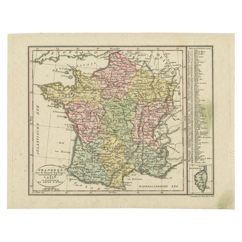
View AllAntique Map of France with an Inset Map of the Island of Corsica, c.1820
Located in Langweer, NL
Antique map titled 'Frankrijk naar de nieuwste bepalingen meerendeels gevolgd naar Lapie'. Beautiful map of France with an inset map of the island of Corsica. Includes a table with r...
Category
Antique 19th Century Dutch Maps
Materials
Paper
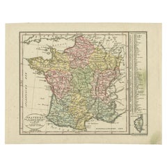
$170 Sale Price
20% Off
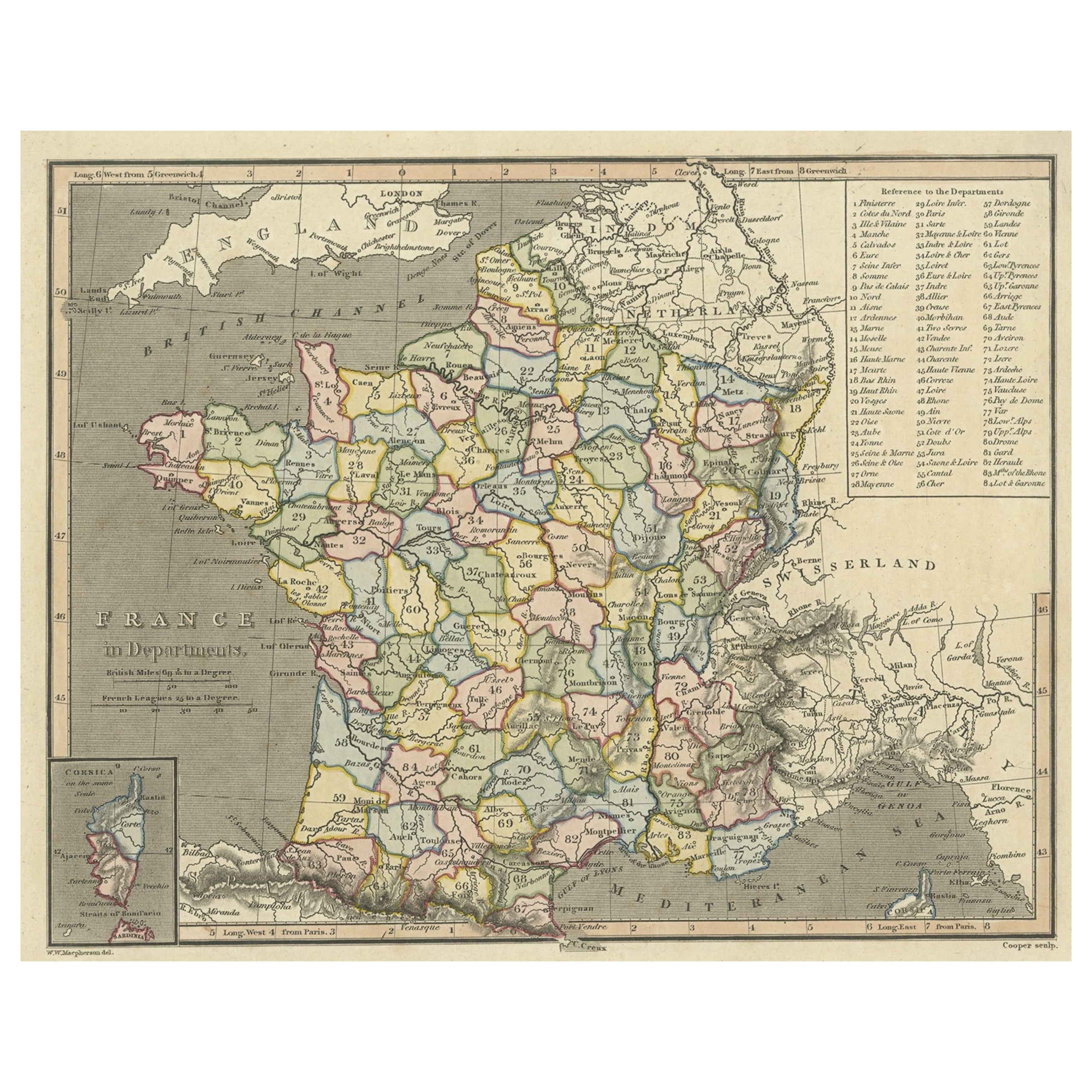
Antique Map of France with Inset Map of the Island of Corsica, 1820
Located in Langweer, NL
Antique map titled 'France in Departments'. Old map of France, with small inset map of the island of Corsica. Includes a table with reference to the departments.
Artists and Engr...
Category
Antique 19th Century Maps
Materials
Paper
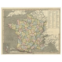
$245 Sale Price
20% Off
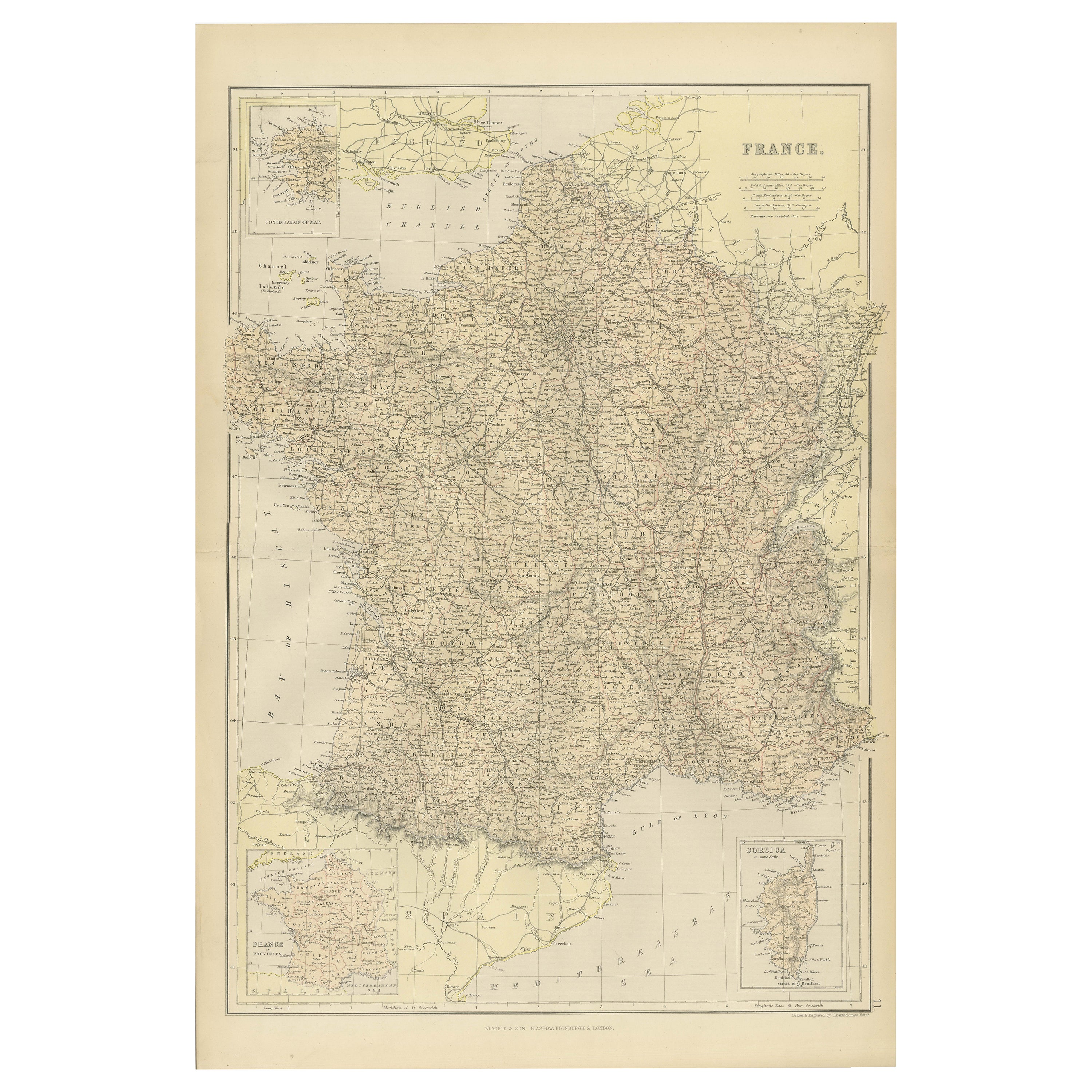
1882 Map of France Highlighting Political Boundaries, Cities, Insets of Corsica
Located in Langweer, NL
This 1882 map of France, published by Blackie and Son as part of the 'Comprehensive Atlas and Geography of the World,' offers a detailed depiction of the country during the late 19th...
Category
Antique 1880s Maps
Materials
Paper

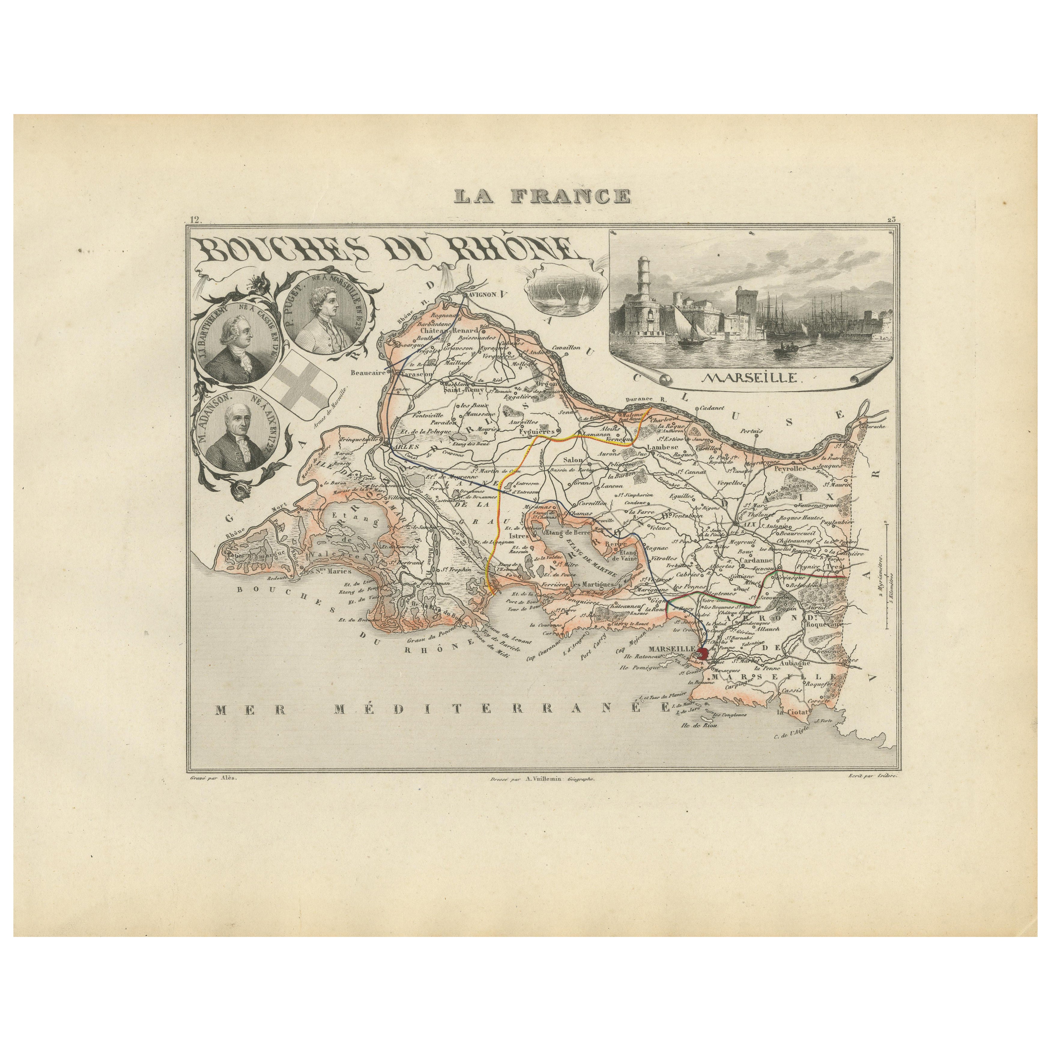
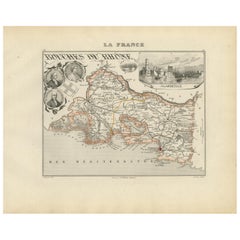
Map of Bouches-du-Rhône France with Marseille and Rhône Delta, 19th Century
Located in Langweer, NL
Map of Bouches-du-Rhône France with Marseille and Rhône Delta, 19th Century
Description:
This finely engraved 19th-century map of the Bouches-du-Rhône department in southeastern Fra...
Category
Antique Mid-19th Century French Maps
Materials
Paper
Antique Map of France, 1903, with Inset of Paris and Corsica
Located in Langweer, NL
Title: Antique Map of France, 1903, with Inset of Paris and Corsica
Description:
This antique map, titled "France," was engraved and published in 1903 by the renowned W. & A.K. John...
Category
Early 20th Century Maps
Materials
Paper

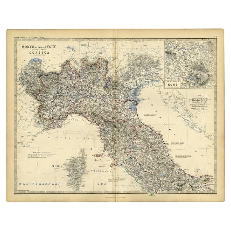
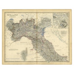
Antique Map of Italy and Corsica, c.1860
Located in Langweer, NL
Antique map titled 'North & Central Italy and the Island of Corsica'.
Old map of North and Central Italy, and the island of Corsica. With an inset map of the region of Rome. Orig...
Category
Antique 19th Century Maps
Materials
Paper
$103 Sale Price
20% Off
You May Also Like
Beautiful Colour French Antique 1856 Hand Watercolour Map of Dept Des La Corse
Located in West Sussex, Pulborough
We are delighted to offer for sale this stunning 1856 hand watercolour map of the Austrian Alps titled Dept Des La Course taken from the Atlas National ...
Category
Antique 1850s French Early Victorian Maps
Materials
Paper

Geographical Antique Map of Principality of Monaco
By Bruno Santini
Located in Alessandria, Piemonte
ST/609 - Interesting antique color map of Monaco Principality in French language : "Carte qui contient le Principauté de Piémont, le Monferrat et la comté de...
Category
Antique Late 18th Century Italian Other Maps
Materials
Paper

Large Original Antique Map of The South of Italy. John Dower, 1861
Located in St Annes, Lancashire
Great map of the South of Italy
Lithograph engraving by John Dower
Original colour
Published, 1861
Unframed
Good condition
Free shipping
Category
Antique 1860s English Victorian Maps
Materials
Paper

Antique Map of Principality of Monaco
By Antonio Vallardi Editore
Located in Alessandria, Piemonte
ST/619 - "Old Geographical Atlas of Italy - Topographic map of ex-Principality of Monaco" -
ediz Vallardi - Milano -
A somewhat special edition ---
Category
Antique Late 19th Century Italian Other Prints
Materials
Paper

Large Original Antique Map of Italy. John Dower, 1861
Located in St Annes, Lancashire
Great map of Italy
Lithograph engraving by John Dower
Original colour
Published, 1861
Unframed
Good condition / repair to top right corner seen in last image
Category
Antique 1860s English Victorian Maps
Materials
Paper

Italy, Central and Southern Part. Century Atlas antique map
Located in Melbourne, Victoria
'The Century Atlas. Italy, Central and Southern Part.'
Original antique map, 1903.
Inset maps of Sicily and Naples.
Central fold as issued. Map name an...
Category
Early 20th Century Victorian More Prints
Materials
Lithograph

More Ways To Browse
Antique Napoleonic
Antique Ivory Collectables
Antique Village Soft
Portrait Of Napoleon
French Wine Map
Napoleon Engraving
Pink Wine Glass
Antique Military Memorabilia
Emperors Robe
Nouvel Glass
6x10 Rug
Styles Of Antique Desks
Black And White Coffee Table
Metal Relief
Curved Velvet Couch
Velvet Curved Sofa
Wood Round Coffee Tables
Antique Paper Flowers