Items Similar to Antique Map of France with Inset Map of the Island of Corsica, 1820


Want more images or videos?
Request additional images or videos from the seller
1 of 6
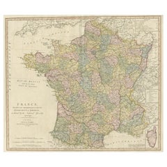
Antique Map of France with Inset Map of the Island of Corsica, 1820
About the Item
Antique map titled 'France in Departments'. Old map of France, with small inset map of the island of Corsica. Includes a table with reference to the departments.
Artists and Engravers: Engraved by Cooper. Published by Sherwood, Neely and Jones.
Condition: Very good, original/contemporary hand coloring. General age-related toning, blank verso. Please study image carefully.
Date: 1820
Overall size: 26.5 x 21 cm.
Image size: 24 x 14.5 cm.
We sell original antique maps to collectors, historians, educators and interior decorators all over the world. Our collection includes a wide range of authentic antique maps from the 16th to the 20th centuries. Buying and collecting antique maps is a tradition that goes back hundreds of years. Antique maps have proved a richly rewarding investment over the past decade, thanks to a growing appreciation of their unique historical appeal. Today the decorative qualities of antique maps are widely recognized by interior designers who appreciate their beauty and design flexibility. Depending on the individual map, presentation, and context, a rare or antique map can be modern, traditional, abstract, figurative, serious or whimsical. We offer a wide range of authentic antique maps for any budget.
- Dimensions:Height: 8.27 in (21 cm)Width: 10.44 in (26.5 cm)Depth: 0 in (0.01 mm)
- Materials and Techniques:
- Period:
- Date of Manufacture:1820
- Condition:
- Seller Location:Langweer, NL
- Reference Number:
About the Seller
5.0
Platinum Seller
These expertly vetted sellers are 1stDibs' most experienced sellers and are rated highest by our customers.
Established in 2009
1stDibs seller since 2017
1,933 sales on 1stDibs
Typical response time: <1 hour
- ShippingRetrieving quote...Ships From: Langweer, Netherlands
- Return PolicyA return for this item may be initiated within 14 days of delivery.
More From This SellerView All
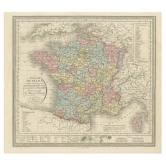
- Antique Map of France with an Inset Map of the Island of Corsica, c.1820Located in Langweer, NLAntique map titled 'Frankrijk naar de nieuwste bepalingen meerendeels gevolgd naar Lapie'. Beautiful map of France with an inset map of the island of Corsica. Includes a table with r...Category
Antique 19th Century Maps
MaterialsPaper
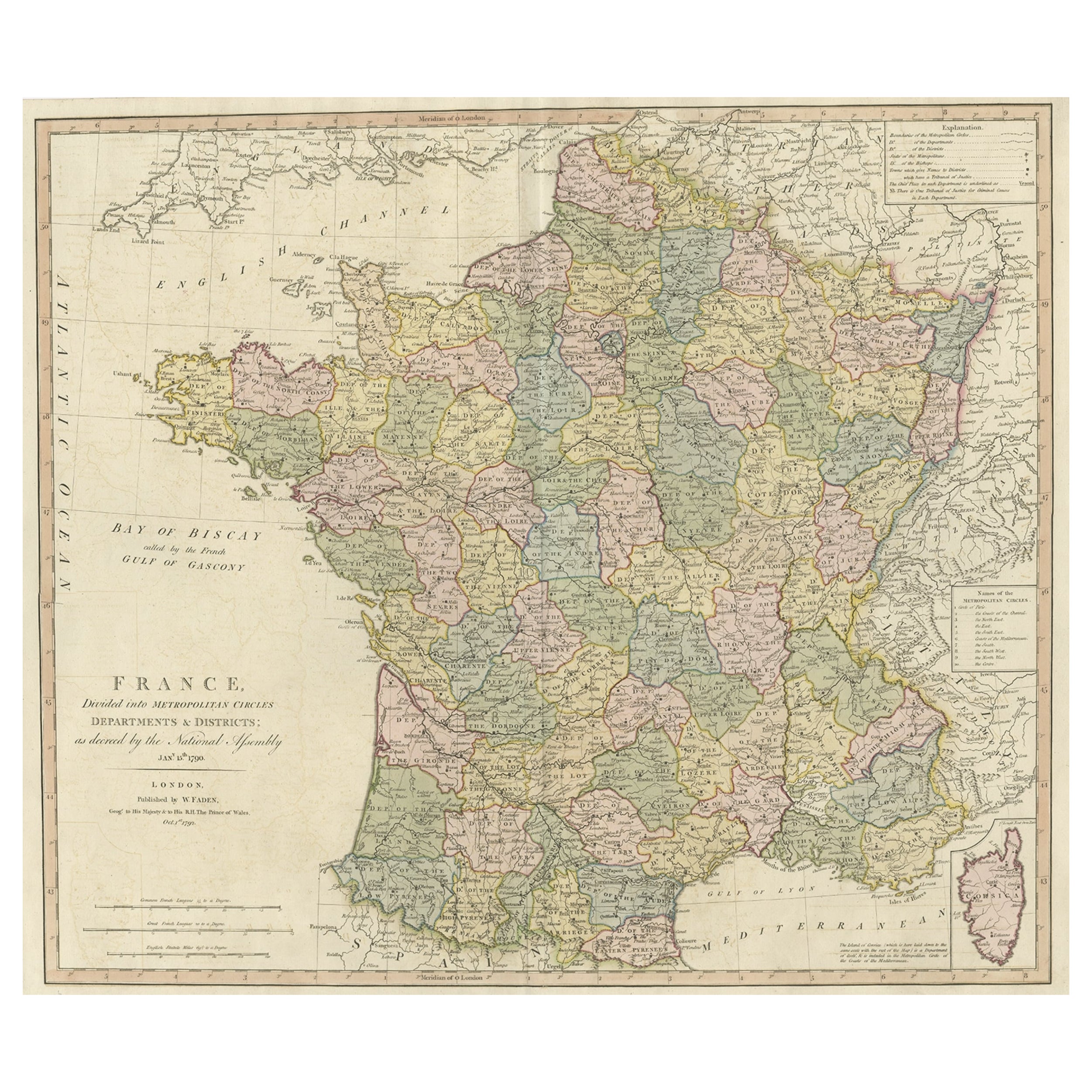
- Large Antique Map of France, with a Small Inset of the Island of Corsica, 1792Located in Langweer, NLAntique map titled 'France divided into Metropolitan Circles (..)'. Large, original antique map of France, with a small inset of the island of Corsica. Published by W. Faden, 179...Category
Antique 1790s Maps
MaterialsPaper
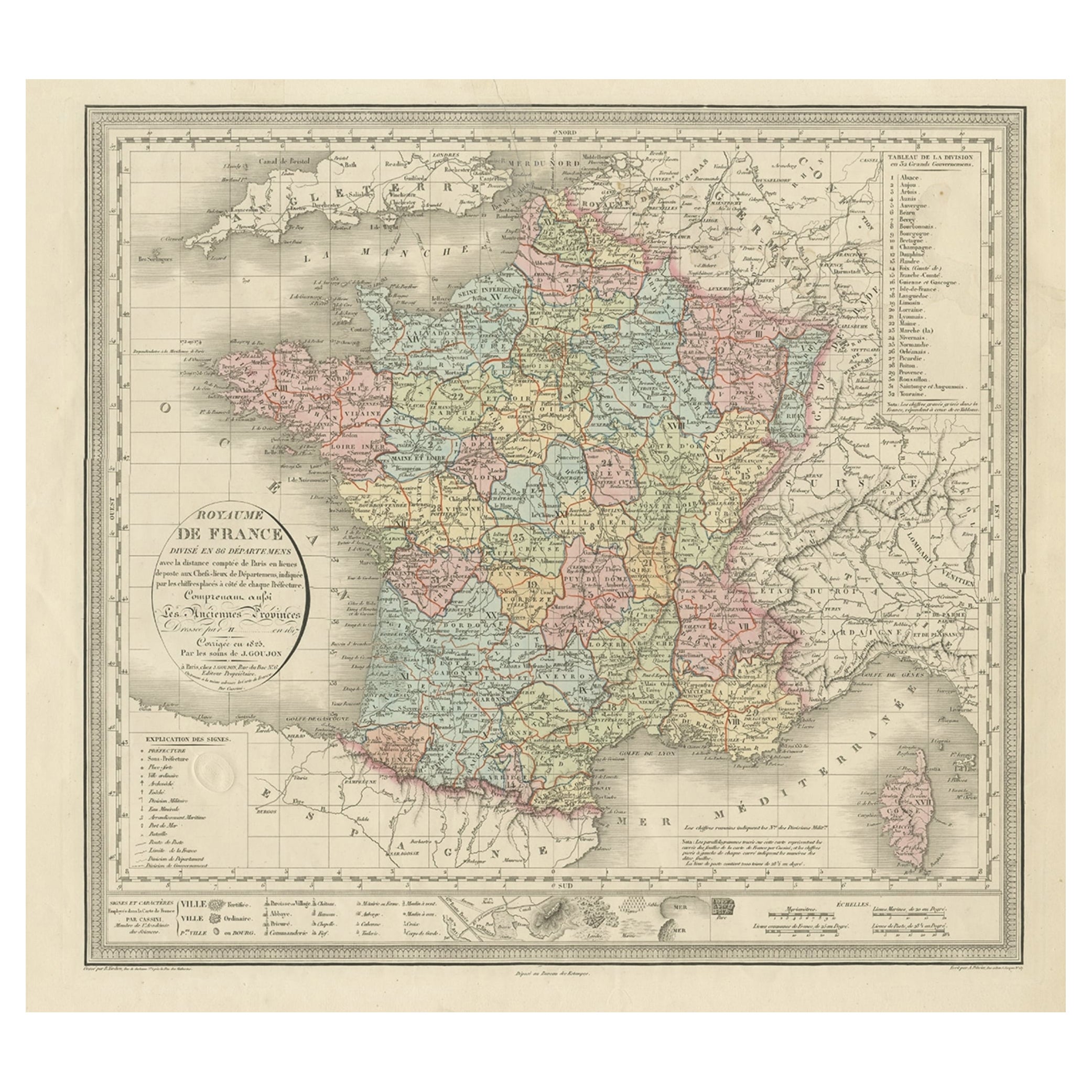
- Antique Map of France and the Island of Corsica, c.1825Located in Langweer, NLAntique map titled 'Royaume de France divisé en 86 Départemens'. Old map of France, revised in 1825. Also shows the Island of Corsica. Source unknown, to be determined. Artists and E...Category
Antique 19th Century Maps
MaterialsPaper
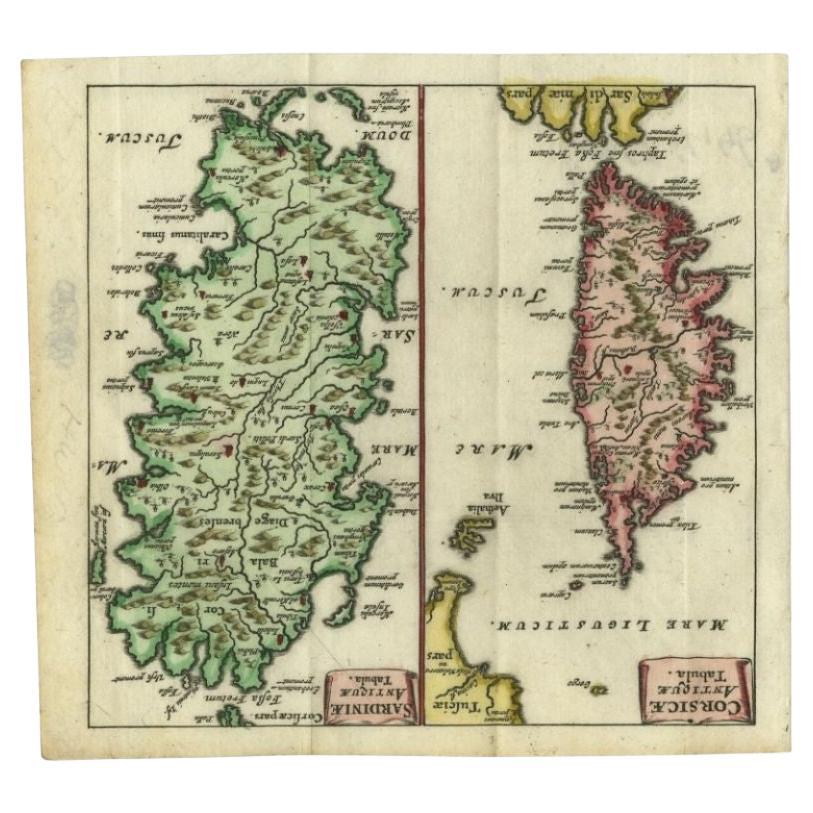
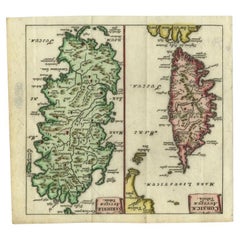
- Antique Map of the Islands of Corsica and Sardinia, 1685Located in Langweer, NLAntique map titled 'Corsicae Antiquae Tabula - Sardiniae Antiquae Tabula.' Two charming miniature maps on one sheet, showing the islands Corsica and Sardinia from the pocket atlas 'I...Category
Antique 17th Century Maps
MaterialsPaper
- Antique Map of Scotland With an Inset Map of the Shetland Islands, 1854Located in Langweer, NLStunning Map of Scotland that will look beautiful in any setting framed on the wall. Description: Large Antique map titled 'Scotland with its Islands, drawn from the Topographical surveys...Category
Antique 1850s Maps
MaterialsPaper
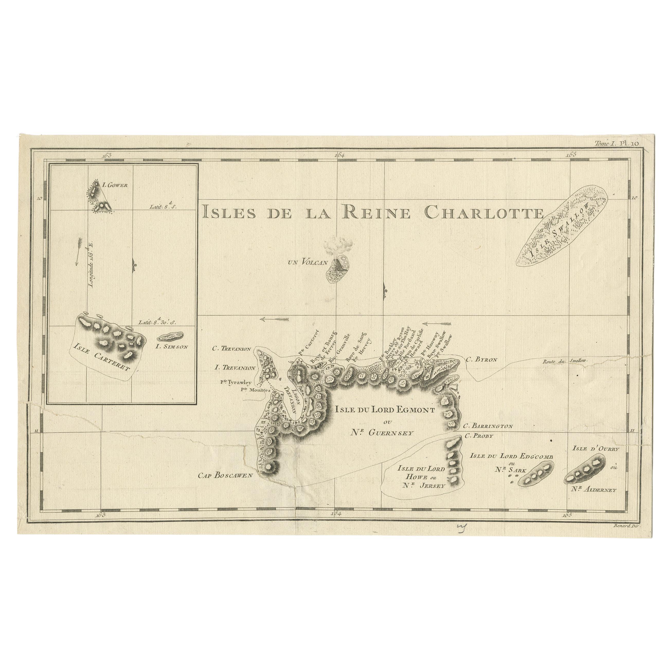
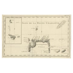
- Antique Map of the Santa Cruz Islands with Inset of Carteret and Gower IslandsLocated in Langweer, NLAntique map titled 'Isles de la Reine Charlotte (..)'. A detailed chart of the Santa Cruz islands, to the north of the New Hebrides, with Carteret's track in "Swallow"; including an ...Category
Antique Late 18th Century Maps
MaterialsPaper


You May Also Like
- Old Nautical Map of CorsicaLocated in Alessandria, PiemonteST/556/1 - Old map of Corsica isle, surveyed by Captain Hell, of the French Royal Navy in 1824, engraved and published on 1874, with additions and corre...Category
Antique Early 19th Century English Other Prints
MaterialsPaper
- Original Antique Map of Canada, Arrowsmith, 1820Located in St Annes, LancashireGreat map of Canada. Drawn under the direction of Arrowsmith. Copper-plate engraving. Published by Longman, Hurst, Rees, Orme and Brown, 1820 ...Category
Antique 1820s English Maps
MaterialsPaper
- Original Antique Map of Europe, Arrowsmith, 1820Located in St Annes, LancashireGreat map of Europe Drawn under the direction of Arrowsmith. Copper-plate engraving. Published by Longman, Hurst, Rees, Orme and Brown, 1820 ...Category
Antique 1820s English Maps
MaterialsPaper
- Original Antique Map of Italy. Arrowsmith. 1820Located in St Annes, LancashireGreat map of Italy Drawn under the direction of Arrowsmith Copper-plate engraving Published by Longman, Hurst, Rees, Orme and Brown, 1820 Unframed.Category
Antique 1820s English Maps
MaterialsPaper
- 1854 Map of Massachusetts, Connecticut and Rhode Island, Antique Wall MapLocated in Colorado Springs, COThis striking wall map was published in 1854 by Ensign, Bridgman & Fanning and has both full original hand-coloring and original hardware. This impression is both informative and highly decorative. The states are divided into counties, outlined in red, green, and black, and subdivided into towns. Roads, canals, and railroad lines are prominently depicted, although they are not all labeled. The mapmakers also marked lighthouses, banks, churches, and prominent buildings, with a key at right. The map is an informative and comprehensive overview of the infrastructural development of New England prior to the Civil War. Physical geographies depicted include elevation, conveyed with hachure marks, rivers and lakes. The impression features an inset map of Boston...Category
Antique 19th Century American Maps
MaterialsPaper
- Original Antique Map of South Africa, Arrowsmith, 1820Located in St Annes, LancashireGreat map of South Africa. Drawn under the direction of Arrowsmith. Copper-plate engraving. Published by Longman, Hurst, Rees, Orme and Br...Category
Antique 1820s English Maps
MaterialsPaper


Recently Viewed
View AllMore Ways To Browse
Size 1820
French Antique Island
Antique Old World Map
Old World Antique Map
Old Antique World Map
Old World Antique Maps
Antique Old Map Of The World
Rare Map France
French 16th Table
French Table 16th Century
Antique 16th Century Tables
Old And Nee
Cooper Antique
Antique Map Table
World Map Table
1820 World Map
Antique Maps Of London
Antique Map Of London