Items Similar to Map of India and Southeast Asia from Ptolemaic Geography – 16th Century Woodcut


Want more images or videos?
Request additional images or videos from the seller
1 of 10
Map of India and Southeast Asia from Ptolemaic Geography – 16th Century Woodcut
$2,244.01
£1,689.39
€1,900
CA$3,091.27
A$3,462.02
CHF 1,806.43
MX$42,287.13
NOK 22,983.01
SEK 21,664.24
DKK 14,463.06
About the Item
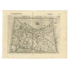
Map of India and Southeast Asia from Ptolemaic Geography – 16th Century Woodcut
This remarkable hand-colored woodcut map, originally designed according to the geographical knowledge of Claudius Ptolemy, offers a fascinating and highly stylized depiction of India and Southeast Asia as understood in antiquity and the early Renaissance. The map represents “India Extra Gangem” and its surrounding seas, capturing both historical and mythical geography that dominated European understanding of Asia before the Age of Discovery.
The cartography features a trapezoidal projection typical of Ptolemaic maps and is bounded by latitudinal and longitudinal lines annotated in Roman numerals. Prominent features include the "Sinus Gangeticus" (Bay of Bengal), "Magnus Sinus" (the Gulf of Thailand or South China Sea), and "Mare Indicum" (Indian Ocean). Numerous locations are named in Latinized classical form, such as “Taprobana” (Sri Lanka), and “Aurea Chersonesus” (Malay Peninsula), as well as the Ganges River and imagined mountain ranges and settlements.
What makes this print particularly desirable is its vibrant original hand-coloring and the surviving text visible on the reverse, confirming it was published as part of a Latin edition of Ptolemy’s 'Geographia'. These editions, especially from the early to mid-16th century, often came from important centers of humanist scholarship such as Basel or Strasbourg. The map is not only a geographic artifact but a testament to Renaissance-era printing, illustrating how ancient knowledge was transmitted and interpreted through woodcut printing techniques.
Collectors and scholars alike value this map for its aesthetic qualities, historical significance, and insight into pre-modern conceptions of Asia. Its distinctively medieval view of geography, with distorted coastlines and imaginative landmasses, contrasts sharply with modern cartography and makes it a visually captivating piece.
Condition Report:
The print is in very good condition considering its age. The colors are still vibrant, and the woodcut impression remains strong and clear. Slight age-toning is visible, and there is a faint central fold as originally issued. Some minor discoloration or marginal wear is present, but there are no tears or repairs. The verso text is clearly visible, adding to its authenticity.
Framing Tips:
This map would benefit from a museum-grade mount and framing. Use a light cream or antique white mat to complement the aged paper and enhance the vivid colors of the woodcut. A gold-leaf or natural wood frame will suit its Renaissance origins beautifully. Consider UV-protective glass to preserve the pigments and paper integrity over time. This map makes a stunning centerpiece in any collection of early cartography or historical prints.
- Dimensions:Height: 15.6 in (39.6 cm)Width: 19.89 in (50.5 cm)Depth: 0.01 in (0.2 mm)
- Materials and Techniques:Paper,Engraved
- Place of Origin:
- Period:
- Date of Manufacture:1535
- Condition:The print is in very good condition considering its age. The colors are still vibrant, and the woodcut impression remains strong and clear. Slight age-toning is visible, and there is a faint central fold as originally issued.
- Seller Location:Langweer, NL
- Reference Number:Seller: BHZ93751stDibs: LU3054342599822
About the Seller
5.0
Recognized Seller
These prestigious sellers are industry leaders and represent the highest echelon for item quality and design.
Platinum Seller
Premium sellers with a 4.7+ rating and 24-hour response times
Established in 2009
1stDibs seller since 2017
2,533 sales on 1stDibs
Typical response time: <1 hour
- ShippingRetrieving quote...Shipping from: Langweer, Netherlands
- Return Policy
Authenticity Guarantee
In the unlikely event there’s an issue with an item’s authenticity, contact us within 1 year for a full refund. DetailsMoney-Back Guarantee
If your item is not as described, is damaged in transit, or does not arrive, contact us within 7 days for a full refund. Details24-Hour Cancellation
You have a 24-hour grace period in which to reconsider your purchase, with no questions asked.Vetted Professional Sellers
Our world-class sellers must adhere to strict standards for service and quality, maintaining the integrity of our listings.Price-Match Guarantee
If you find that a seller listed the same item for a lower price elsewhere, we’ll match it.Trusted Global Delivery
Our best-in-class carrier network provides specialized shipping options worldwide, including custom delivery.More From This Seller
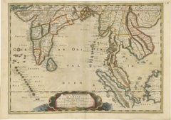
View All1698 Mercator Ptolemaic Map of Asia East of the Ganges
Located in Langweer, NL
**Catalogue Description:**
**Title:** Tab. XI. Asiae, comprehendens Indiam extra Gangem.
**Description:**
This is an exquisite Ptolemaic map depicting Asia east of the Ganges, ti...
Category
Antique 1680s Maps
Materials
Paper

$888 Sale Price
20% Off
Rare and Very Old Antique Map of South East Asia, Published circa 1574
Located in Langweer, NL
A very fine impression of this map of the Malay Peninsula, Sumatra, Java, with Singapore denoted as 'Cinca Pula'.
Highly distorted and inaccurate map by Girolamo Ruscelli after J...
Category
Antique 16th Century Maps
Materials
Paper

$1,133 Sale Price
20% Off
Free Shipping
Old Ptolemaic Map of the Region Between the Persian Gulf and Caspian Sea, 1598
Located in Langweer, NL
"Tabula Asiae V", Ptolemy/Ruscelli
Subject: Persia - Iran
Period: 1598 (published)
Publication: Geografia di Claudio Tolomeo Allessadrino…
Claudius Ptolemy was a mathematician, ast...
Category
Antique 16th Century Maps
Materials
Paper
$377 Sale Price
20% Off
Original Antique Woodcut Map of Persia
Located in Langweer, NL
Antique map titled 'Tabula V Asiae'. Important early woodcut map of Persia, depicting the area of Mesopotamia, Armenia and the Gulf, to the Caspian and Carmania (Iran). Includes name...
Category
Antique 16th Century Maps
Materials
Paper
$557 Sale Price
20% Off
1654 Nicolas Sanson Map of Southern India and Southeast Asia
Located in Langweer, NL
1654 Nicolas Sanson Map of Southern India and Southeast Asia - Partie Meridionale de L'Inde
This 1654 map by Nicolas Sanson, titled "Partie Meridionale de L'Inde en deux Presqu'Is...
Category
Antique 1650s Maps
Materials
Paper
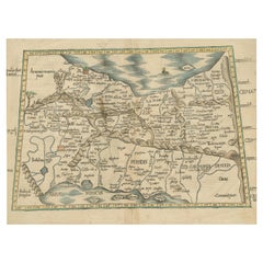
Original Antique Ptolemaic Map of the Region of Thailand and Malaysia
Located in Langweer, NL
Antique map titled 'Tabula Asiae XI'. Based on the interpretations of Solinus and Munster, this Ptolemaic map covers the region roughly of Thailand and Malaysia. An oddly shaped (Mal...
Category
Antique 16th Century Maps
Materials
Paper

$538 Sale Price
20% Off
You May Also Like
Engraving Depicting 16th Century Map of Terra Sancta
Located in Buchanan, MI
Abraham Ortelius (Flemish, 1527-1598) Terra Sancta.
Engraving depicting 16th century map of Terra Sancta. Site 15" x 19.5.
Category
Antique 18th Century and Earlier Maps
Materials
Paper

1627 Hendrik Hondius Map Entitled "Vltoniae Orientalis Pars, " Ric.a009
Located in Norton, MA
1627 Hendrik Hondius map entitled
"Vltoniae orientalis pars,"
Ric.a009
Title:
Vltoniae orientalis : pars
Title (alt.) :
Ultoniae orientalis pars
Creator:
Mercator, Gerh...
Category
Antique 17th Century Dutch Maps
Materials
Paper

Antique Map - Mare Pacificum - Etching by Johannes Janssonius - 1650s
By Johannes Janssonius
Located in Roma, IT
Mare Pacificum is an antique map realized in 1650 by Johannes Janssonius (1588-1664).
The Map is Hand-colored etching, with coeval watercolorang.
Good conditions with slight foxing...
Category
1650s Modern Figurative Prints
Materials
Etching

16th c. woodcut map - Tabula Asiae Vlll
By Sebastian Münster
Located in Santa Monica, CA
SEBASTIAN MUNSTER (1488-1652)
ASIAE TABVLA Vlll 1540 (45)
Woodcut from Munster's edition of Geographia Universalis, Basel, Henri Petri. 1545 edit...
Category
16th Century Old Masters Landscape Prints
Materials
Woodcut

$950 Sale Price
29% Off
Antique French Map of Asia Including China Indoneseia India, 1783
Located in Amsterdam, Noord Holland
Very nice map of Asia. 1783 Dedie au Roy.
Additional information:
Country of Manufacturing: Europe
Period: 18th century Qing (1661 - 1912)
Condition: Overall Condition B (Good Used)...
Category
Antique 18th Century European Maps
Materials
Paper

$648 Sale Price
20% Off
Antique Map - Mar Di Athiopia - Etching by Johannes Janssonius - 1650s
By Johannes Janssonius
Located in Roma, IT
Antique Map - Mar Di Athiopia is an antique map realized in 1650 by Johannes Janssonius (1588-1664).
The Map is Hand-colored etching, with coeval watercolorang.
Good conditions wit...
Category
1650s Modern Figurative Prints
Materials
Etching

More Ways To Browse
Gold Frame 16th Century
Thai Artifact
Indian Reverse Glass
Red Retro Dining Set
Antique Silver Glasses Case
Carlo Scarpa 1934 Chairs
Christofle Marly
1900 Antique Chairs
Glass Table Italian Round
Mid Century Colonial
Alvar Aalto Poster
Geometric Metal Table
Post Modern High Chairs
United Nations
Vintage Vine Rug
Cancel An Order
Antique Framing Square
Silver Metal Chair