Items Similar to Map of the Margraviate and Electorate of Brandenburg by de Beaurain - ca.1750


Want more images or videos?
Request additional images or videos from the seller
1 of 10
Map of the Margraviate and Electorate of Brandenburg by de Beaurain - ca.1750
$517.42
$646.7820% Off
£383.44
£479.3020% Off
€432
€54020% Off
CA$706.38
CA$882.9820% Off
A$785.82
A$982.2820% Off
CHF 411.94
CHF 514.9220% Off
MX$9,602.53
MX$12,003.1720% Off
NOK 5,245.50
NOK 6,556.8820% Off
SEK 4,937.92
SEK 6,172.3920% Off
DKK 3,289.21
DKK 4,111.5120% Off
Shipping
Retrieving quote...The 1stDibs Promise:
Authenticity Guarantee,
Money-Back Guarantee,
24-Hour Cancellation
About the Item
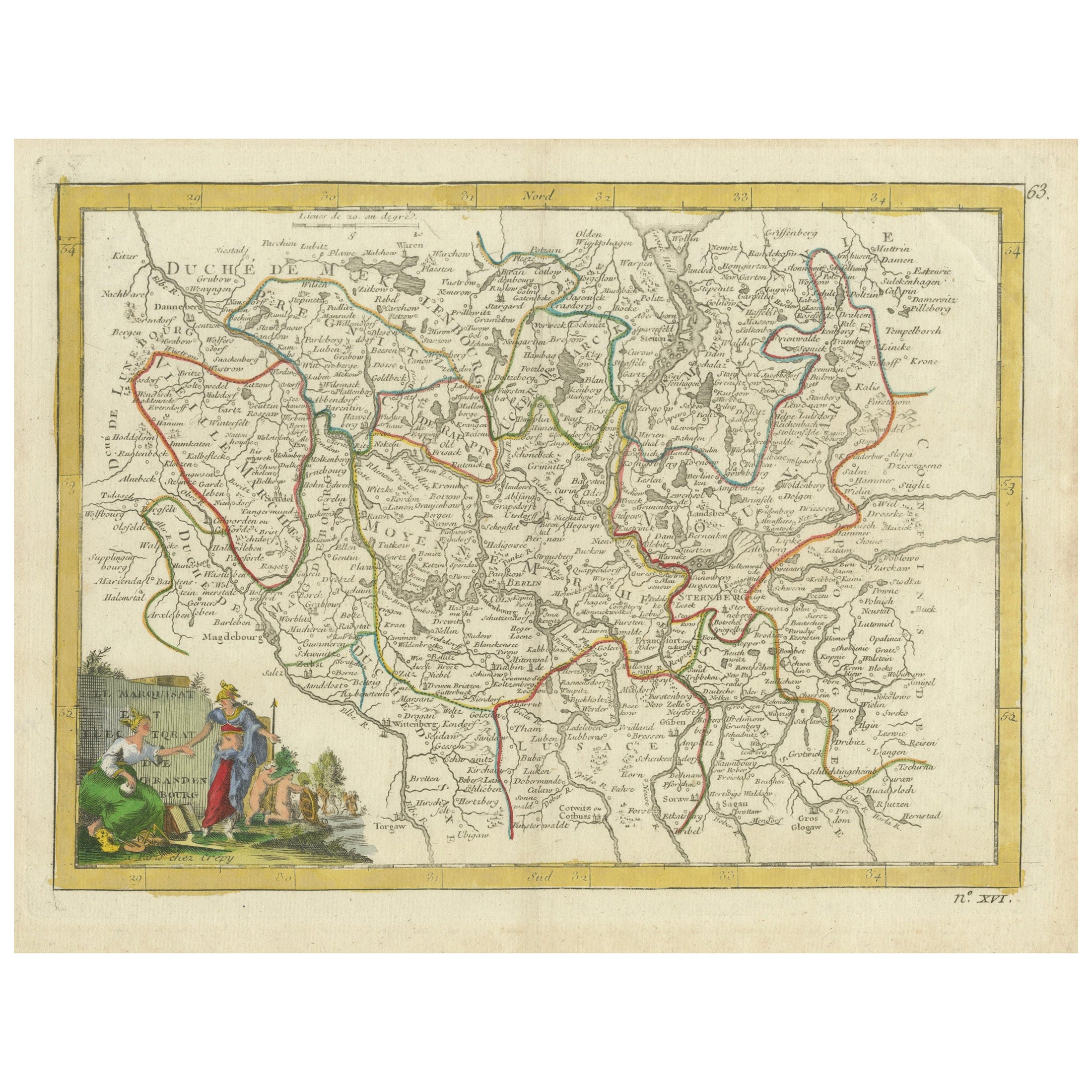
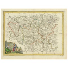
Historical Map of the Margraviate and Electorate of Brandenburg by Chevalier de Beaurain - Circa 1750
This impressive historical map, titled "Carte du Marquisat et Electorat de Brandebourg," was created by the renowned French cartographer Jean de Beaurain, also known as Chevalier de Beaurain, around 1750. As the official geographer to the King of France, Beaurain was highly respected for his meticulous and scholarly approach to cartography, and this map is a fine example of his dedication to accuracy and detail.
The map represents the Margraviate and Electorate of Brandenburg, a significant territorial entity within the Holy Roman Empire that later became the core of the Kingdom of Prussia. The map also encompasses parts of the Duchy of Mecklenburg to the north and Silesia to the southeast. The detailed geographical representation includes major rivers, forests, and an extensive network of towns and villages. The old hand coloring beautifully highlights the political divisions and administrative boundaries, with shades of green, yellow, and pink marking different territories.
One of the most captivating elements of this map is the ornate title cartouche located at the bottom left. The cartouche, framed with intricate rococo ornamentation and crowned by a royal coat of arms with fleur-de-lis, exemplifies the decorative style typical of French cartography during the mid-18th century. The cartouche inscription reads:
Carte du Marquisat et Electorat de Brandebourg
Assujettie aux Observations Astronomiques de l'Académie Royale et à quelques-unes de M. l'Abbé Expilly
Dédiée et Présentée au Roy
Par son très humble très obéissant et très fidèle serviteur et sujet le Chevalier de Beaurain, Géographe Ordinaire de Sa Majesté
This dedication to the King of France underlines Beaurain’s official role and his meticulous efforts to present the most accurate geographical information available at the time. The map is divided into four distinct "Marches" or regions: Vieille Marche, Celle de Prignitz, Moyenne Marche, and Nouvelle Marche, as indicated in the legend.
The map’s precision is remarkable, with countless place names and administrative subdivisions presented clearly and accurately. Rivers, roads, and forests are finely engraved, and the hand coloring further enhances the distinction between regions and territories. The map also includes an elaborate mileage scale at the lower right, framed by baroque ornamentation, demonstrating both aesthetic appeal and practical use.
The map’s production technique involved copperplate engraving, where the image was carefully incised into a copper plate, inked, and pressed onto paper. The resulting print was then hand-colored, giving each piece a unique character and vibrancy.
Condition: The map is in good condition with vivid hand coloring and sharp engraving. Minor signs of aging, such as light toning and faint creases, are present but do not detract from the overall quality. The paper is robust and well-preserved.
Framing Tips: To emphasize the map’s historic elegance, choose a dark wooden or gilded frame with a cream or light beige mat. UV-protected, non-reflective glass is recommended to preserve the vibrant hand coloring and delicate paper. Archival-quality framing materials will ensure long-lasting protection and an impressive presentation.
- Dimensions:Height: 21.26 in (54 cm)Width: 28.75 in (73 cm)Depth: 0.01 in (0.2 mm)
- Materials and Techniques:Paper,Engraved
- Period:1750-1759
- Date of Manufacture:circa 1750
- Condition:The map is in good condition with vivid hand coloring and sharp engraving. Minor signs of aging, such as light toning and faint creases, are present but do not detract from the overall quality. The paper is robust and well-preserved.
- Seller Location:Langweer, NL
- Reference Number:Seller: BG-13842-281stDibs: LU3054344169302
About the Seller
5.0
Recognized Seller
These prestigious sellers are industry leaders and represent the highest echelon for item quality and design.
Platinum Seller
Premium sellers with a 4.7+ rating and 24-hour response times
Established in 2009
1stDibs seller since 2017
2,494 sales on 1stDibs
Typical response time: 1 hour
- ShippingRetrieving quote...Shipping from: Langweer, Netherlands
- Return Policy
Authenticity Guarantee
In the unlikely event there’s an issue with an item’s authenticity, contact us within 1 year for a full refund. DetailsMoney-Back Guarantee
If your item is not as described, is damaged in transit, or does not arrive, contact us within 7 days for a full refund. Details24-Hour Cancellation
You have a 24-hour grace period in which to reconsider your purchase, with no questions asked.Vetted Professional Sellers
Our world-class sellers must adhere to strict standards for service and quality, maintaining the integrity of our listings.Price-Match Guarantee
If you find that a seller listed the same item for a lower price elsewhere, we’ll match it.Trusted Global Delivery
Our best-in-class carrier network provides specialized shipping options worldwide, including custom delivery.More From This Seller
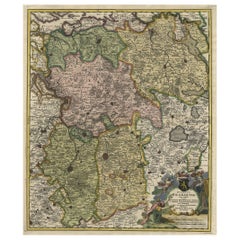
View AllAntique Map of the Electorate of Brandenburg by Georges-Louis Le Rouge, 1768
Located in Langweer, NL
Antique Map of the Electorate of Brandenburg by Georges-Louis Le Rouge, 1748
This 1748 map by Georges-Louis Le Rouge, titled "Le Marquisat et Electorat de Brandenbourg," depicts the...
Category
Antique 1760s Maps
Materials
Paper
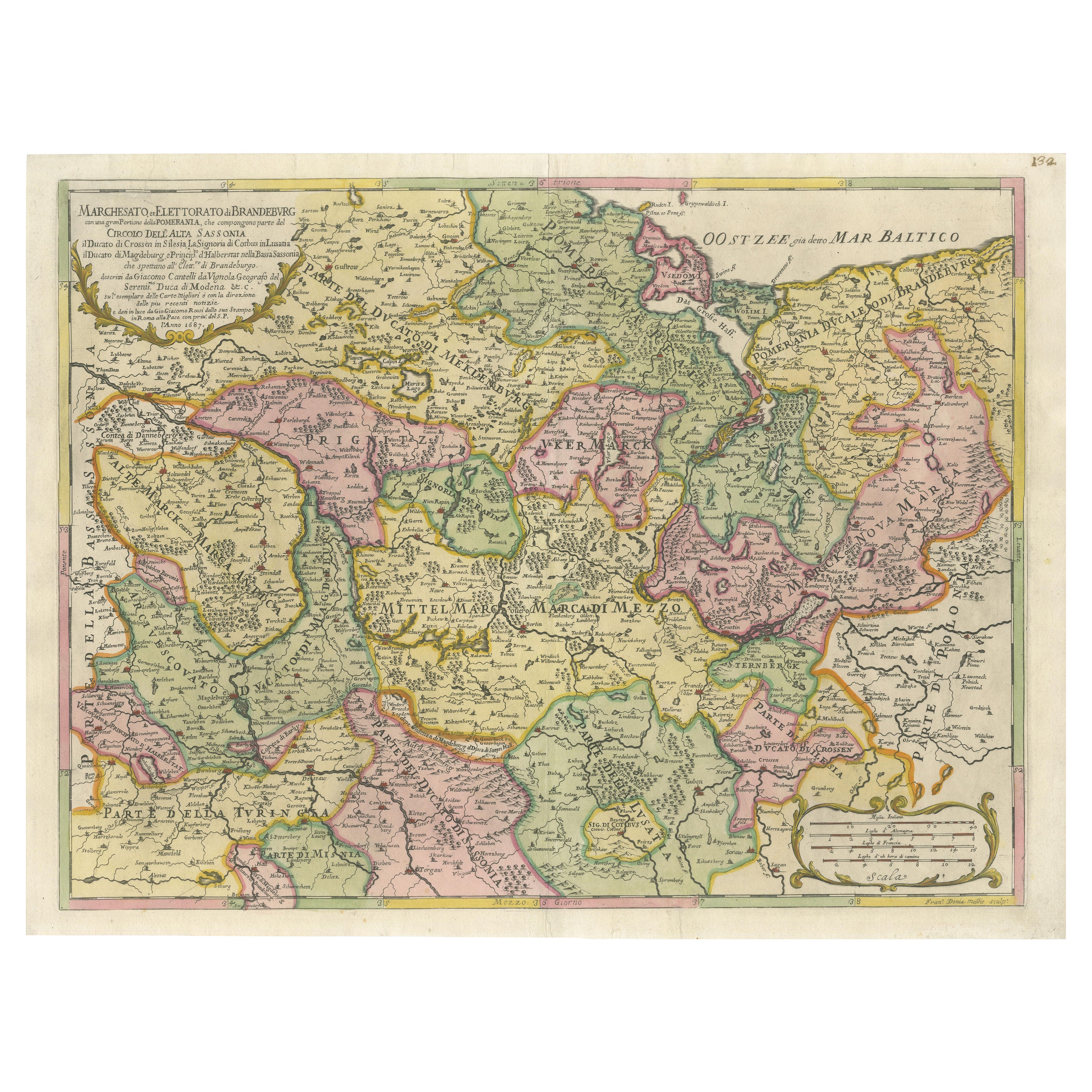
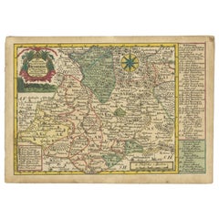
Old Map of the Margraviate of Brandenburg by Giacomo Cantelli da Vignola, 1687
Located in Langweer, NL
Historical Map of the Margraviate of Brandenburg by Giacomo Cantelli da Vignola - 1687
This magnificent map, titled Marchesato, et Elettorato di Brandeburgo con una gran Porzione ...
Category
Antique 1680s Maps
Materials
Paper

$517 Sale Price
20% Off
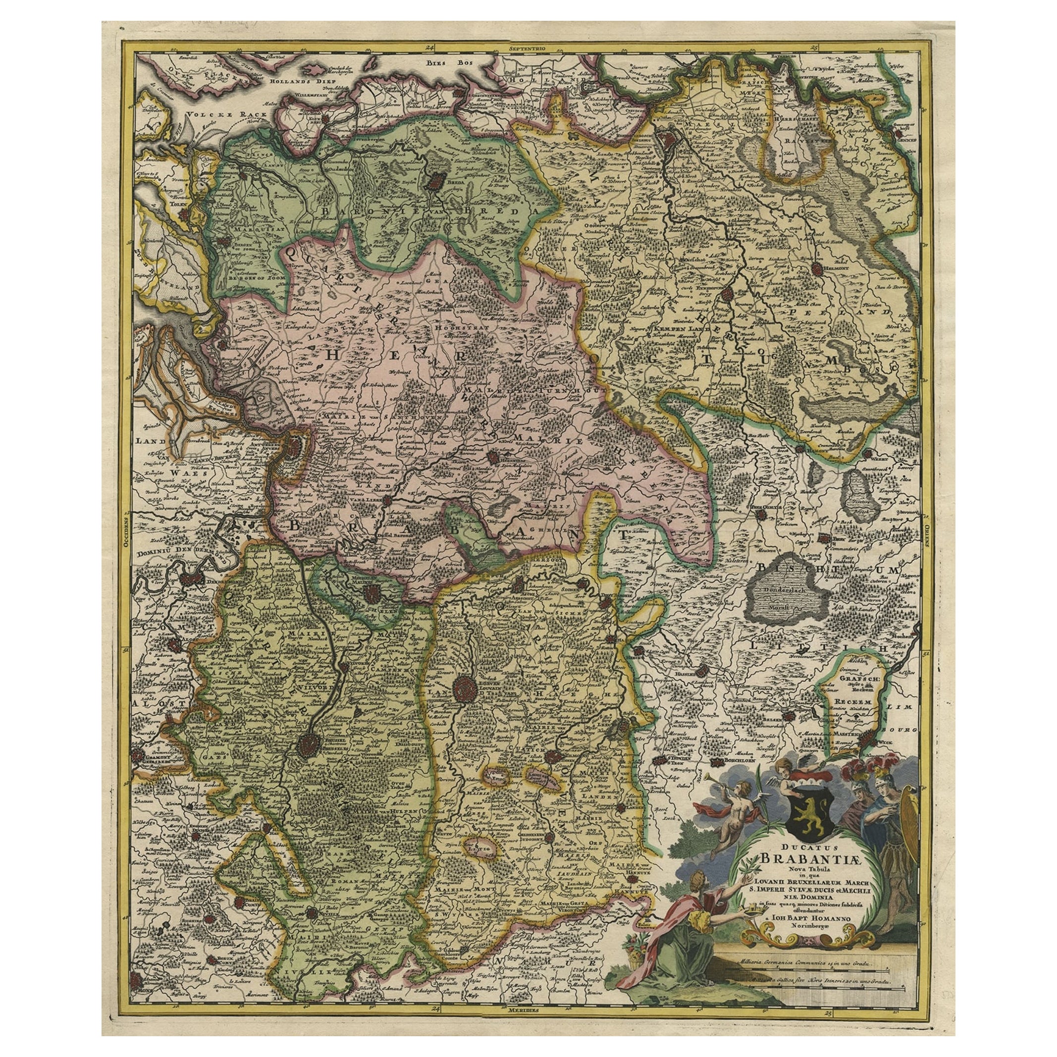
Map of Duchy of Brabant Centered on Fortress of Louvain or Leuven, Belgium, 1720
Located in Langweer, NL
Antique map titled 'Ducatus Brabantiae Nova Tabula in qua Lovanii Bruxellarum March S. Impreii Sylvae Ducis et Merchliniae Dominia.'
This fully engraved copperplate map...
Category
Antique 1720s Maps
Materials
Paper
$939 Sale Price
20% Off
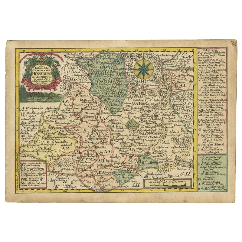
Antique Map of the Region of Henneberg by Schreiber, 1749
Located in Langweer, NL
Antique map titled 'Die Gefürstete Henneberg'. Map of the region of Henneberg, Germany. This map originates from 'Atlas Selectus von allen Konigreichen und L...
Category
Antique 18th Century Maps
Materials
Paper
$89 Sale Price
20% Off
Antique Map of the Lorraine 'North-East France' by J. B. Homann, circa 1720
Located in Langweer, NL
Antique map of Lorraine in north-east France by J. B. Homann. Covering the area around Metz, Nancy and Sarrebruck with Luxembourg in the North and Mulhouse in Southeast. With a decor...
Category
Antique Early 18th Century Maps
Materials
Paper

$613 Sale Price
20% Off
Antique Map of the County of Hainaut by Jaillot, 1692
Located in Langweer, NL
Antique map titled 'Le Comté de Haynaut divisé en Chateliensis, Balliages, Prevoste's (..)'. Large map of the county of Hainaut (France) with its most important cities, Mons (Bergen)...
Category
Antique 17th Century Maps
Materials
Paper

$213 Sale Price
20% Off
You May Also Like
17th Century Hand-Colored Map of a Region in West Germany by Janssonius
By Johannes Janssonius
Located in Alamo, CA
This attractive highly detailed 17th century original hand-colored map is entitled "Archiepiscopatus Maghdeburgensis et Anhaltinus Ducatus cum terris adjacentibus". It was published ...
Category
Antique Mid-17th Century Dutch Maps
Materials
Paper

18th Century Emanuel Bowen Map of County of York, c.1740
By Emanuel Bowen
Located in Royal Tunbridge Wells, Kent
Antique 18th century British rare and original Emanuel Bowen (1694-1767) map of the County of York divided into its Ridings and subdivided into wapontakes, mounted in solid wood fram...
Category
Antique Early 18th Century British Maps
Materials
Paper

Antique County Map, Shropshire, English, Atlas Engraving, Richard Blome, C.1673
Located in Hele, Devon, GB
This is an antique county map of Shropshire. An English, framed atlas engraving by Richard Blome, dating to the 17th century and later.
A treat for the collector or county native, ...
Category
Antique 17th Century British Restauration Maps
Materials
Glass, Wood, Paper

Antique Map Of Brabantia Ducantus By Bleau Circa 1640
Located in Brussels, Brussels
map of theBrabantia Ducantus (Belgium) circa 1640 by Bléau. Bléau was well known for antique atlas that he draw during the 17 century
beautiful map, double page folded in the middle,...
Category
Antique 17th Century French Renaissance Maps
Materials
Paper

18th Century Hand-Colored Homann Map of Germany, Including Frankfurt and Berlin
By Johann Baptist Homann
Located in Alamo, CA
An 18th century hand-colored map entitled "Tabula Marchionatus Brandenburgici et Ducatus Pomeraniae quae sunt Pars Septentrionalis Circuli Saxoniae Superioris" by Johann Baptist Homa...
Category
Antique Early 18th Century German Maps
Materials
Paper

Map of Oxfordshire coloured 18th century engraving by Thomas Kitchin
By Thomas Kitchin
Located in London, GB
To see our other original maps, scroll down to "More from this Seller" and below it click on "See all from this Seller" - or send us a message if you cannot find the poster you want....
Category
1760s Landscape Prints
Materials
Engraving

More Ways To Browse
Coat Of Arms Engraving
Roman Inscription
Prussia Plate
Marche Aux Fleurs
Vintage Scandanavian Chairs
19th Century Red Glass
Antique French Console Table Tables
Silver Bowl Large
Antique French Silk
Down Couch
Used Lighter Art
Blue Edge Glass
Mahogany 1950s Furniture
Solid Mahogany Table
Dessert Glasses
Geometric Glass Table
Mid Century Pin
6x10 Rug