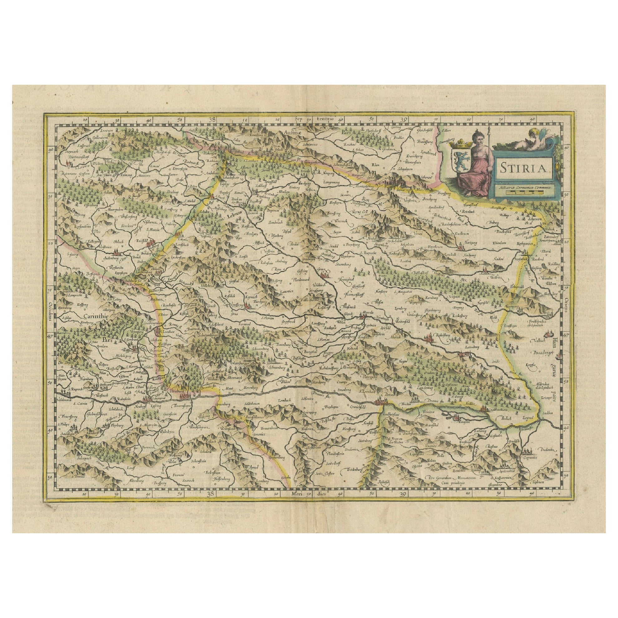
Items Similar to Map of Styria by William Blaeu, 1645: A Masterpiece of 17th-Century Cartography


Want more images or videos?
Request additional images or videos from the seller
1 of 6
Map of Styria by William Blaeu, 1645: A Masterpiece of 17th-Century Cartography
$828.68
£610.32
€690
CA$1,127.36
A$1,252.74
CHF 656.45
MX$15,362.63
NOK 8,372.63
SEK 7,876.66
DKK 5,252.86
Shipping
Retrieving quote...The 1stDibs Promise:
Authenticity Guarantee,
Money-Back Guarantee,
24-Hour Cancellation
About the Item
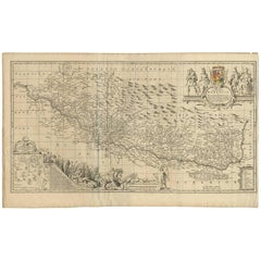
This 1645 map, created by Willem Janszoon Blaeu, represents Styria (Steyrmark), a historical region in present-day Austria, located in the Alpine regions. Blaeu, one of the most significant cartographers of the Golden Age of Dutch mapmaking, produced the map with the precision and artistry that define his works.
Map Features:
1. Topography and Geography: The map clearly depicts the mountainous terrain of Styria, including rivers, forests, and settlements.
2. Decorative Elements: The upper-right corner features a title cartouche adorned with a seated female figure holding a coat of arms, a hallmark of Blaeu's decorative style.
3. Borders: Neighboring regions such as Carinthia (Carintia) to the west and Hungary to the east are marked and delineated.
Historical Context: Willem Blaeu (1571–1638) founded his map-publishing business in Amsterdam in 1599, capitalizing on the city's growing wealth and global trade. His maps became renowned for their accuracy, craftsmanship, and decorative elements.
After Willem’s death, his son Joan Blaeu continued the business and expanded its reach. Joan's *Atlas Maior*, published in 1662, remains one of the most important cartographic works ever created. In addition to the *Atlas Maior*, the *Toonneel der Steden* (1649) showcased maps of fortification cities across the Netherlands.
This map of Styria reflects the Blaeu family's lasting contribution to cartography, combining geographical knowledge with artistic beauty. Let me know if you need further analysis or details for documentation purposes.
- Dimensions:Height: 18.51 in (47 cm)Width: 23.04 in (58.5 cm)Depth: 0.01 in (0.2 mm)
- Materials and Techniques:Paper,Engraved
- Period:1640-1649
- Date of Manufacture:1645
- Condition:This map of Styria is in excellent condition with clean paper, wide margins, vibrant hand-coloring, and crisp printing. It shows no tears, stains, or creases, reflecting careful preservation and enhancing its historical and aesthetic value.
- Seller Location:Langweer, NL
- Reference Number:Seller: BG-13664-31stDibs: LU3054342816122
About the Seller
5.0
Recognized Seller
These prestigious sellers are industry leaders and represent the highest echelon for item quality and design.
Platinum Seller
Premium sellers with a 4.7+ rating and 24-hour response times
Established in 2009
1stDibs seller since 2017
2,494 sales on 1stDibs
Typical response time: 1 hour
- ShippingRetrieving quote...Shipping from: Langweer, Netherlands
- Return Policy
Authenticity Guarantee
In the unlikely event there’s an issue with an item’s authenticity, contact us within 1 year for a full refund. DetailsMoney-Back Guarantee
If your item is not as described, is damaged in transit, or does not arrive, contact us within 7 days for a full refund. Details24-Hour Cancellation
You have a 24-hour grace period in which to reconsider your purchase, with no questions asked.Vetted Professional Sellers
Our world-class sellers must adhere to strict standards for service and quality, maintaining the integrity of our listings.Price-Match Guarantee
If you find that a seller listed the same item for a lower price elsewhere, we’ll match it.Trusted Global Delivery
Our best-in-class carrier network provides specialized shipping options worldwide, including custom delivery.More From This Seller
View AllAn Original Antique Mid-17th Century Blaeu Map of Styria in Southeastern Austria
Located in Langweer, NL
This is an antique map of Styria (referred to as “Stiria” or “Steyrmarck”), published by the renowned Dutch cartographer Willem Janszoon Blaeu (often simply “Blaeu”). The first editi...
Category
Antique 1640s Maps
Materials
Paper
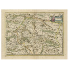
Antique Map of Styria by Mercator 'circa 1650'
Located in Langweer, NL
Antique map titled 'Stiria'. Original antique map of Styria, Austria. Published by G. Mercator, circa 1650.
Category
Antique Mid-17th Century Maps
Materials
Paper

$432 Sale Price
20% Off
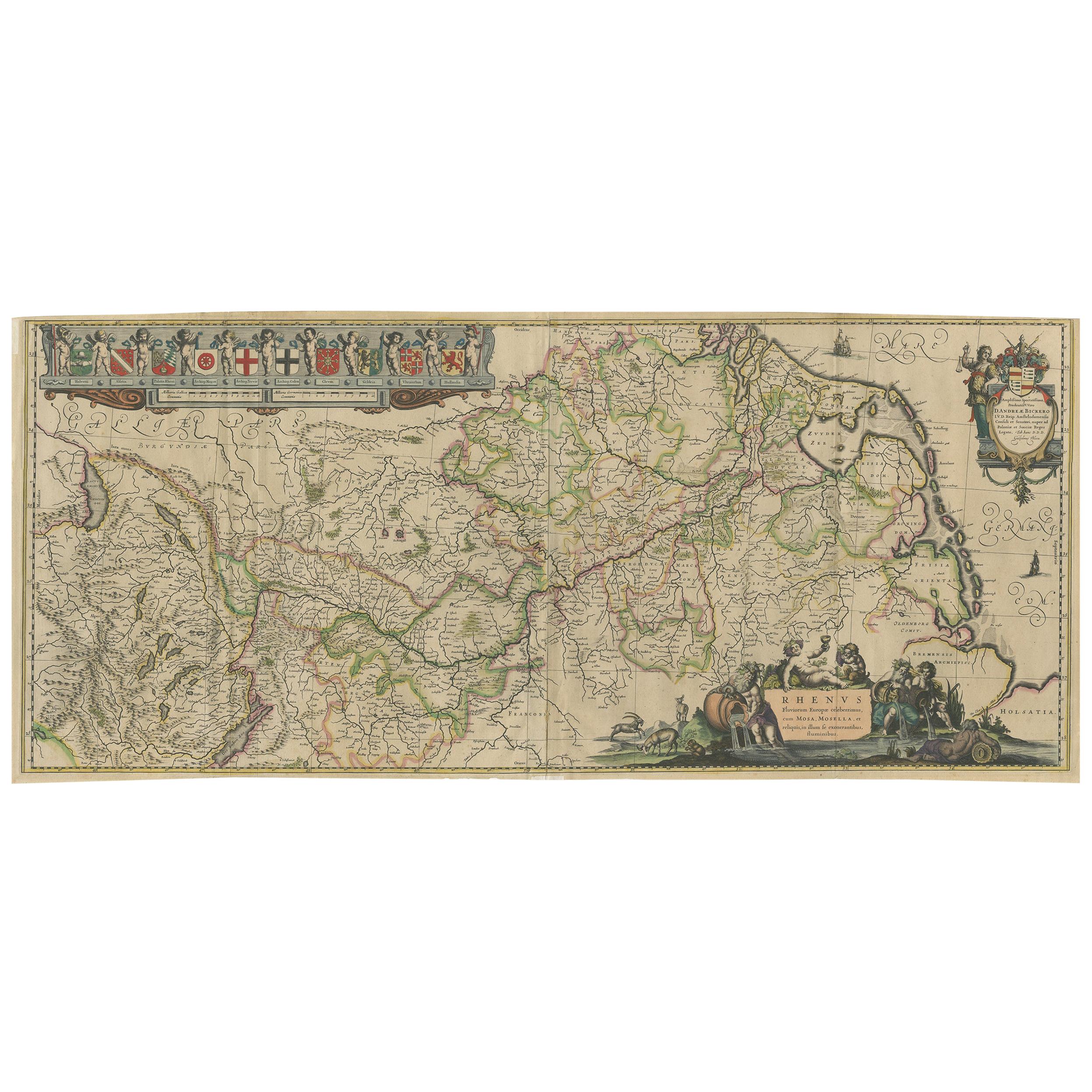
Large Rhine River Map, Moselle and Meuse, by Willem Blaeu, Hand-coloured - 1640
Located in Langweer, NL
Rhine River & Tributaries Antique Map by Willem Blaeu, c.1640
This spectacular mid-seventeenth-century copper-engraved map, titled in Latin “Rhenus Fluvio...
Category
Antique Mid-17th Century Dutch Maps
Materials
Paper

$1,441 Sale Price
20% Off
Antique Map of Austria by F. de Wit, 1690
Located in Langweer, NL
Antique map titled 'Circuli Austriaci pars Septentrionalis in qua Archiducatus'. Decorative and detailed map of Austria by F. de Wit.
Category
Antique Late 17th Century Maps
Materials
Paper

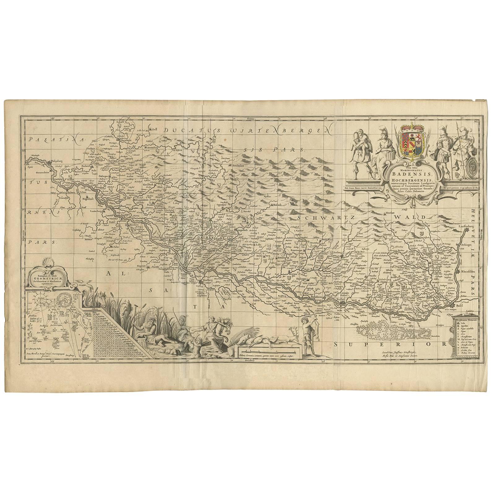
Antique Map of Switzerland by J. van Waesbergen, circa 1680
Located in Langweer, NL
Antique map titled 'Vera totius marchionatus Badensis, et Hochbergensis ; ceterorumque ducatuum ladngravionatuum et comitatuum ad principes huius nominis spectantium geometr: astro: ...
Category
Antique Late 17th Century Maps
Materials
Paper
$787 Sale Price
20% Off
Old Map of the Western Part of Central Europe, c.1680
Located in Langweer, NL
Antique map titled 'Carta nova accurate del Passagio et strada dalli Paesi Bassi'. Old map of the western portion of Central Europe. Oriented to the Northeast.
Artists and Engrav...
Category
Antique 17th Century Maps
Materials
Paper

$360 Sale Price
20% Off
You May Also Like
1640 Willem Blaeu Map Entitled "Contado di molise et principato vltra, " Ric.a003
By Willem Blaeu
Located in Norton, MA
1640 Willem Blaeu map entitled
"Contado di molise et principato vltra,"
Colored
Ric. a003
Measures: 38 x 49.6 cm and wide margins
DBLAEU.
Cou...
Category
Antique 17th Century Dutch Maps
Materials
Paper

1640 Joan Bleau Map Entitled"Diocecese de rheims et le pais de rethel, " Eic.a011
Located in Norton, MA
1640 Joan Bleau map entitled
"Diocecese de rheims et le pais de rethel,"
Ric.a011
OAN BLAEU
Diocecese de Rheims, et le pais de Rethel.
Handcolored engraving, c.1640.
...
Category
Antique 17th Century Dutch Maps
Materials
Paper

17th Century Hand Colored Map of the Liege Region in Belgium by Visscher
By Nicolaes Visscher II
Located in Alamo, CA
An original 17th century map entitled "Leodiensis Episcopatus in omnes Subjacentes Provincias distincté divisusVisscher, Leodiensis Episcopatus" by Nicolaes Visscher II, published in Amsterdam in 1688. The map is centered on Liege, Belgium, includes the area between Antwerp, Turnhout, Roermond, Cologne, Trier and Dinant.
This attractive map is presented in a cream-colored mat measuring 30" wide x 27.5" high. There is a central fold, as issued. There is minimal spotting in the upper margin and a tiny spot in the right lower margin, which are under the mat. The map is otherwise in excellent condition.
The Visscher family were one of the great cartographic families of the 17th century. Begun by Claes Jansz Visscher...
Category
Antique Late 17th Century Dutch Maps
Materials
Paper

1571-1638 Willem Blaeu map entitled, "Ilcadorino, " Hand Colored Ric0009
Located in Norton, MA
Willem Blaeu map entitled,
"Ilcadorino,".
Hand colored.
Description: large, unusual, and nice antique copper engraved map of Ilcadorino, by Willem BL...
Category
Antique 16th Century Dutch Maps
Materials
Paper

17th Century Hand-Colored Map of a Region in West Germany by Janssonius
By Johannes Janssonius
Located in Alamo, CA
This attractive highly detailed 17th century original hand-colored map is entitled "Archiepiscopatus Maghdeburgensis et Anhaltinus Ducatus cum terris adjacentibus". It was published ...
Category
Antique Mid-17th Century Dutch Maps
Materials
Paper

17th Century Nicolas Visscher Map of Southeastern Europe
Located in Hamilton, Ontario
A beautiful, highly detailed map of southeastern Europe by Nicolas Visscher. Includes regions of Northern Italy (showing the cities Bologna, Padua, and Venice), Bohemia, Austria (sho...
Category
Antique 17th Century Dutch Maps
Materials
Paper

$1,350 Sale Price
38% Off
More Ways To Browse
Red Retro Dining Set
Antique Silver Glasses Case
Carlo Scarpa 1934 Chairs
Christofle Marly
1900 Antique Chairs
Glass Table Italian Round
Mid Century Colonial
Alvar Aalto Poster
Geometric Metal Table
Post Modern High Chairs
United Nations
Vintage Vine Rug
Cancel An Order
Antique Framing Square
Silver Metal Chair
Swedish Kilim
Vintage Scandanavian Chairs
Vintage Tropical Furniture