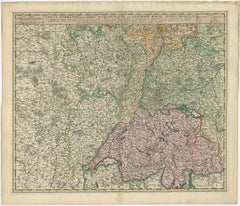
Items Similar to Map of Switzerland by Justus Danckerts, Hand-Colored Engraving ca. 1690


Want more images or videos?
Request additional images or videos from the seller
1 of 11
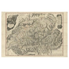
Map of Switzerland by Justus Danckerts, Hand-Colored Engraving ca. 1690
$649.80
£487.06
€550
CA$892.71
A$996.63
CHF 522.22
MX$12,199.73
NOK 6,632.19
SEK 6,253.31
DKK 4,186.80
Shipping
Retrieving quote...The 1stDibs Promise:
Authenticity Guarantee,
Money-Back Guarantee,
24-Hour Cancellation
About the Item
Map of Switzerland by Justus Danckerts, Hand-Colored Engraving ca. 1690
This detailed and attractively hand-colored antique map titled *Helvetiae Rhaetiae et Valesiae, nec non partis Sabaudiae Tabula* was engraved and published by Justus Danckerts in Amsterdam around 1690. It depicts the Swiss Confederacy along with neighboring regions, including Rhaetia (modern Graubünden), Valais, and part of Savoy. This is a quintessential example of late 17th-century Dutch cartography—ornate, richly detailed, and both scientifically useful and visually appealing.
The map is a masterful representation of the geography of the Swiss Alps and surrounding territories. It features major cities such as Zurich, Bern, Basel, Lucerne, and Geneva (Genève), along with an exceptional network of rivers, lakes, mountain ranges, and political boundaries. Lake Geneva (Lemanus Lacus) and parts of the Rhône River system are prominently illustrated.
The regional borders are highlighted in original hand-color, a practice common in maps from this period to distinguish various cantons and territories. In the upper left, a decorative cartouche with scrollwork, draped fabric, and two allegorical figures presents the title. This style of embellishment, with its bold putti and theatrical flair, is characteristic of the Danckerts workshop and helps distinguish this map from earlier works by Blaeu or Janssonius.
Justus Danckerts (1635–1701) came from a renowned family of Dutch mapmakers and publishers. He was part of the third generation of the Danckerts firm and was known for producing high-quality wall maps, atlases, and decorative engravings. His maps were prized for their clarity, vivid hand-coloring, and elegant ornamentation.
This map serves as both a collector’s piece and a decorative artifact of late Dutch Golden Age cartography. It captures a richly detailed vision of Switzerland at a time when it was forming its independent identity in the heart of Europe.
Condition report:
Well-preserved, considering age, but with some edge wear, light age toning, but mostly in the borders. The image itself mostly a clean and detailed sharp impression.
Tips for Framng:
Best framed in dark walnut or gold-leaf wood, with an off-white or pale grey mat to enhance the map’s intricate linework and rich period coloring.
- Dimensions:Height: 20.48 in (52 cm)Width: 23.63 in (60 cm)Depth: 0 in (0.02 mm)
- Materials and Techniques:Paper,Engraved
- Period:Late 17th Century
- Date of Manufacture:circa 1690
- Condition:Well-preserved, considering age, but with some edge wear, light age toning, but mostly in the borders. The image itself mostly a clean and detailed sharp impression.
- Seller Location:Langweer, NL
- Reference Number:Seller: BG-13669-11stDibs: LU3054345364222
About the Seller
5.0
Recognized Seller
These prestigious sellers are industry leaders and represent the highest echelon for item quality and design.
Platinum Seller
Premium sellers with a 4.7+ rating and 24-hour response times
Established in 2009
1stDibs seller since 2017
2,511 sales on 1stDibs
Typical response time: <1 hour
- ShippingRetrieving quote...Shipping from: Langweer, Netherlands
- Return Policy
Authenticity Guarantee
In the unlikely event there’s an issue with an item’s authenticity, contact us within 1 year for a full refund. DetailsMoney-Back Guarantee
If your item is not as described, is damaged in transit, or does not arrive, contact us within 7 days for a full refund. Details24-Hour Cancellation
You have a 24-hour grace period in which to reconsider your purchase, with no questions asked.Vetted Professional Sellers
Our world-class sellers must adhere to strict standards for service and quality, maintaining the integrity of our listings.Price-Match Guarantee
If you find that a seller listed the same item for a lower price elsewhere, we’ll match it.Trusted Global Delivery
Our best-in-class carrier network provides specialized shipping options worldwide, including custom delivery.More From This Seller
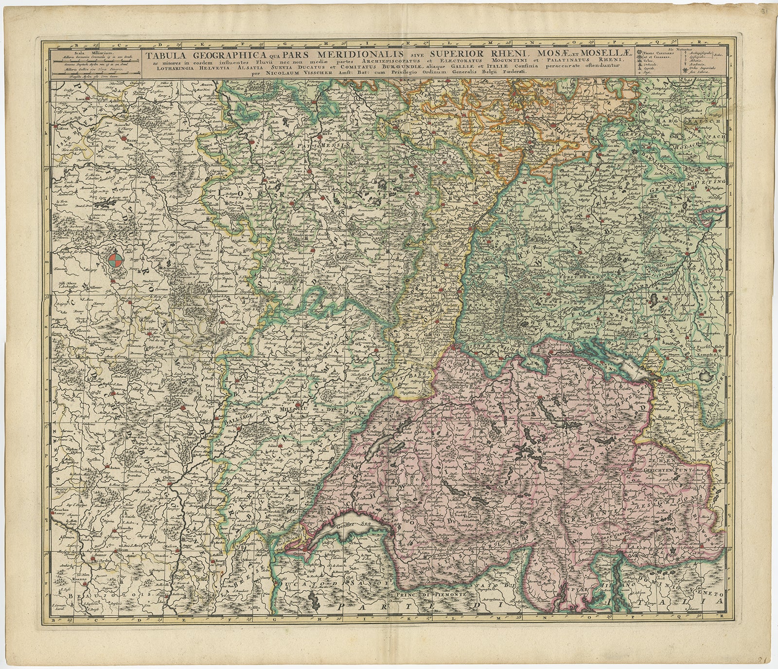
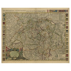
View AllAntique Map of Switzerland by N. Visscher, circa 1690
Located in Langweer, NL
Antique map titled 'Tabula Geogaphica qua Pars Meridionalis sive Superior Rheni, Mosae, et Mosellae (..)'. Published by N. Visscher, Amsterdam, circa 1690. Contemporary coloring.
Category
Antique Late 17th Century Maps
Materials
Paper
$628 Sale Price
20% Off
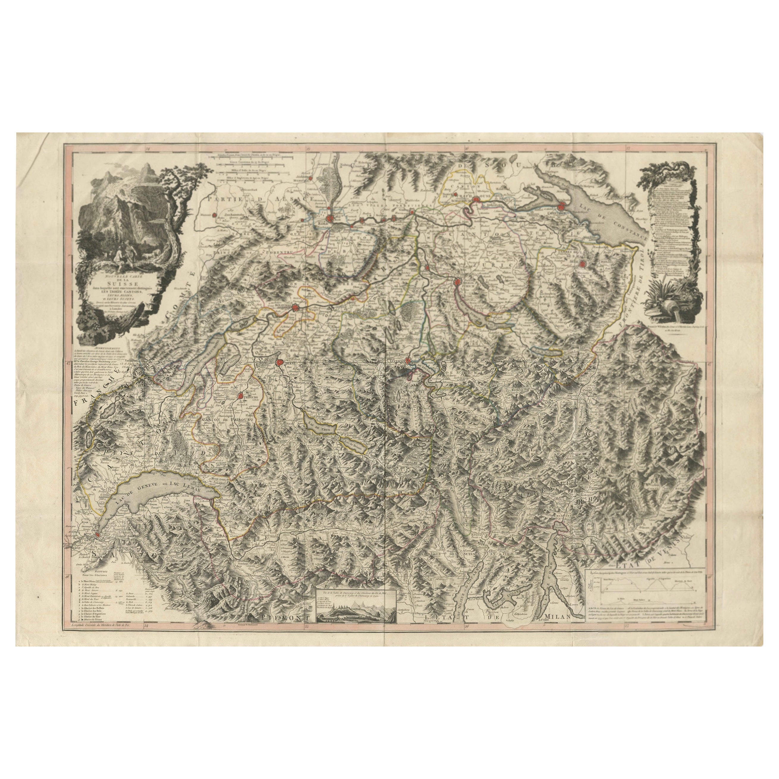
Switzerland Map 1778 – Striking Hand-Colored Copperplate of the Thirteen Cantons
Located in Langweer, NL
Switzerland Map 1778 – Faden’s Hand-Colored Copperplate of the Thirteen Cantons
This striking copperplate engraving, published by William Faden in London in 1778, offers a detailed ...
Category
Antique Late 18th Century European Maps
Materials
Paper
Antique Map of Switzerland by J.B. Homann, 1751
By Johann Baptist Homann
Located in Langweer, NL
Decorative example of Homann's map of Switzerland, with decorative cartouche and the coat of arms of each of the 13 Cantons.
Category
Antique Mid-18th Century Maps
Materials
Paper

$557 Sale Price
20% Off
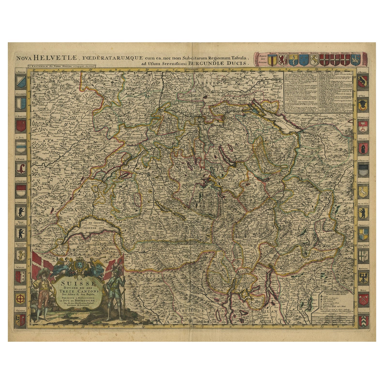
Beautiful Antique Handcolored Map of Switzerland with 33 Coats of Arms, ca.1705
Located in Langweer, NL
Antique map Switerzland titled 'La Suisse Divisee en ses Treze Cantons, ses Alliez & ses Sujets (..)'.
Beautiful map of Switzerland with 33 coats of arms. The map is dedicated to t...
Category
Antique Early 1700s Maps
Materials
Paper
$1,512 Sale Price
20% Off
Free Shipping
Antique Map of Switzerland by Keizer & de Lat, 1788
Located in Langweer, NL
Antique map titled 'La Suisse (..)'. Uncommon original antique map of Switzerland. This map originates from 'Nieuwe Natuur- Geschied- en Handelkundige Zak- en Reisatlas' by Gerrit Br...
Category
Antique Late 18th Century Maps
Materials
Paper

$330 Sale Price
20% Off
Antique Map of Switzerland by Homann Heirs, c.1732
Located in Langweer, NL
Antique map titled 'Potentissimae Helvetiorum Reipublicae (..)'. Beautiful detailed map of Switzerland, showing the 13 cantons. The large title cartouche showing 13 coat of arms of t...
Category
Antique 18th Century Maps
Materials
Paper

$371 Sale Price
20% Off
You May Also Like
17th Century Hand Colored Map of the Liege Region in Belgium by Visscher
By Nicolaes Visscher II
Located in Alamo, CA
An original 17th century map entitled "Leodiensis Episcopatus in omnes Subjacentes Provincias distincté divisusVisscher, Leodiensis Episcopatus" by Nicolaes Visscher II, published in Amsterdam in 1688. The map is centered on Liege, Belgium, includes the area between Antwerp, Turnhout, Roermond, Cologne, Trier and Dinant.
This attractive map is presented in a cream-colored mat measuring 30" wide x 27.5" high. There is a central fold, as issued. There is minimal spotting in the upper margin and a tiny spot in the right lower margin, which are under the mat. The map is otherwise in excellent condition.
The Visscher family were one of the great cartographic families of the 17th century. Begun by Claes Jansz Visscher...
Category
Antique Late 17th Century Dutch Maps
Materials
Paper

Map of Switzerland - Etching - 19th Century
Located in Roma, IT
This map of Netherlands is an etching realized in 19th century.
The state of preservation of the artwork is excellent. The signature "F.B." is engraved on the lower right. At the to...
Category
19th Century Figurative Prints
Materials
Etching

Original Antique Map of Switzerland, Engraved By Barlow, Dated 1807
Located in St Annes, Lancashire
Great map of Switzerland
Copper-plate engraving by Barlow
Published by Brightly & Kinnersly, Bungay, Suffolk.
Dated 1807
Unframed.
Category
Antique Early 1800s English Maps
Materials
Paper

Hand Colored 18th Century Homann Map of Austria Including Vienna & the Danube
By Johann Baptist Homann
Located in Alamo, CA
"Archiducatus Austriae inferioris" is a hand colored map of Austria created by Johann Baptist Homann (1663-1724) and published in Nuremberg, Germany in 1728 shortly after his death. ...
Category
Early 18th Century Old Masters Landscape Prints
Materials
Engraving

Hand Colored 18th Century Homann Map of Austria Including Vienna and the Danube
By Johann Baptist Homann
Located in Alamo, CA
"Archiducatus Austriae inferioris" is a hand colored map of Austria created by Johann Baptist Homann (1663-1724) and published in Nuremberg, Germany in 1728 shortly after his death. ...
Category
Antique Early 18th Century German Maps
Materials
Paper

17th Century Hand-Colored Map of a Region in West Germany by Janssonius
By Johannes Janssonius
Located in Alamo, CA
This attractive highly detailed 17th century original hand-colored map is entitled "Archiepiscopatus Maghdeburgensis et Anhaltinus Ducatus cum terris adjacentibus". It was published ...
Category
Antique Mid-17th Century Dutch Maps
Materials
Paper

More Ways To Browse
Swiss Mountain Furniture
17th Century Dutch Wood Frames
Flair Holland
Blaeu Wall Map
Styles Of Antique Desks
Black And White Coffee Table
Curved Velvet Couch
Velvet Curved Sofa
Wood Round Coffee Tables
Antique Paper Flowers
Oak Brutalist
Used College Furniture
Wood Minimalist Chair
2002 Lamp
Antique Imperial Furniture
Gold Modern Coffee Table
Large Side Tables
18th Century Gilded Furniture