Items Similar to Mountain Elevation Profiles – Alps, Pyrenees, Andes & World Heights 1857


Video Loading
Want more images or videos?
Request additional images or videos from the seller
1 of 12
Mountain Elevation Profiles – Alps, Pyrenees, Andes & World Heights 1857
$429.15
£318.39
€360
CA$587.53
A$658.22
CHF 342.60
MX$8,015.84
NOK 4,364.29
SEK 4,109.93
DKK 2,741.10
Shipping
Retrieving quote...The 1stDibs Promise:
Authenticity Guarantee,
Money-Back Guarantee,
24-Hour Cancellation
About the Item
Mountain Elevation Profiles – Alps, Pyrenees, Andes & World Heights 1857
This intriguing antique print shows comparative elevation profiles titled “Die bekannteren Höhen über der Meeresfläche in vergrösserten Profilen,” meaning “The better-known heights above sea level in enlarged profiles.” It features three main diagrams:
– Top: Profile of the Alps from Northern Germany to Southern Italy, showing major peaks such as Mont Blanc, Monte Rosa, and the Jungfrau, with elevations marked precisely.
– Middle: Profile of the Swiss Alps and neighbouring ranges with detailed annotations of peaks and valleys.
– Bottom: Comparative profiles of non-European mountains including the Andes in South America and African peaks, alongside further Alpine and Pyrenean elevations.
Published in 1857 by Justus Perthes in Gotha as part of Adolf Stieler’s famous Hand-Atlas, these engravings were prepared under the editorial supervision of Heinrich Berghaus, known for his scientific cartography and thematic maps.
This print is significant for its scientific presentation of global mountain heights during a period when comparative geography and natural sciences were advancing rapidly. Such profiles allowed scholars and travellers to visualise and understand altitudinal differences between European mountains and other world ranges, enhancing education in physical geography.
Technique: Copperplate engraving with original hand colouring to highlight elevation contours and mountain shapes. German titles and detailed annotations are engraved with exceptional clarity.
Condition summary: Excellent condition with minimal toning, no tears, repairs, or significant foxing. Colours remain clear and fresh. Paper is firm and stable.
Framing tips: This elevation profile engraving will look impressive in a dark wood or black frame to emphasise its scientific detail, paired with a wide cream or light ivory mount to soften and balance the presentation. UV-protective glass is recommended to preserve its fine engraved lines and original colour clarity for long-term display.
- Dimensions:Height: 14.77 in (37.5 cm)Width: 17.88 in (45.4 cm)Depth: 0.01 in (0.2 mm)
- Materials and Techniques:Paper,Engraved
- Place of Origin:
- Period:
- Date of Manufacture:1857
- Condition:Condition summary: Excellent condition with minimal toning, no tears, repairs, or significant foxing. Colours remain clear and fresh. Paper is firm and stable.
- Seller Location:Langweer, NL
- Reference Number:Seller: BG-05552-101stDibs: LU3054345810472
About the Seller
5.0
Recognized Seller
These prestigious sellers are industry leaders and represent the highest echelon for item quality and design.
Platinum Seller
Premium sellers with a 4.7+ rating and 24-hour response times
Established in 2009
1stDibs seller since 2017
2,493 sales on 1stDibs
Typical response time: <1 hour
- ShippingRetrieving quote...Shipping from: Langweer, Netherlands
- Return Policy
Authenticity Guarantee
In the unlikely event there’s an issue with an item’s authenticity, contact us within 1 year for a full refund. DetailsMoney-Back Guarantee
If your item is not as described, is damaged in transit, or does not arrive, contact us within 7 days for a full refund. Details24-Hour Cancellation
You have a 24-hour grace period in which to reconsider your purchase, with no questions asked.Vetted Professional Sellers
Our world-class sellers must adhere to strict standards for service and quality, maintaining the integrity of our listings.Price-Match Guarantee
If you find that a seller listed the same item for a lower price elsewhere, we’ll match it.Trusted Global Delivery
Our best-in-class carrier network provides specialized shipping options worldwide, including custom delivery.More From This Seller
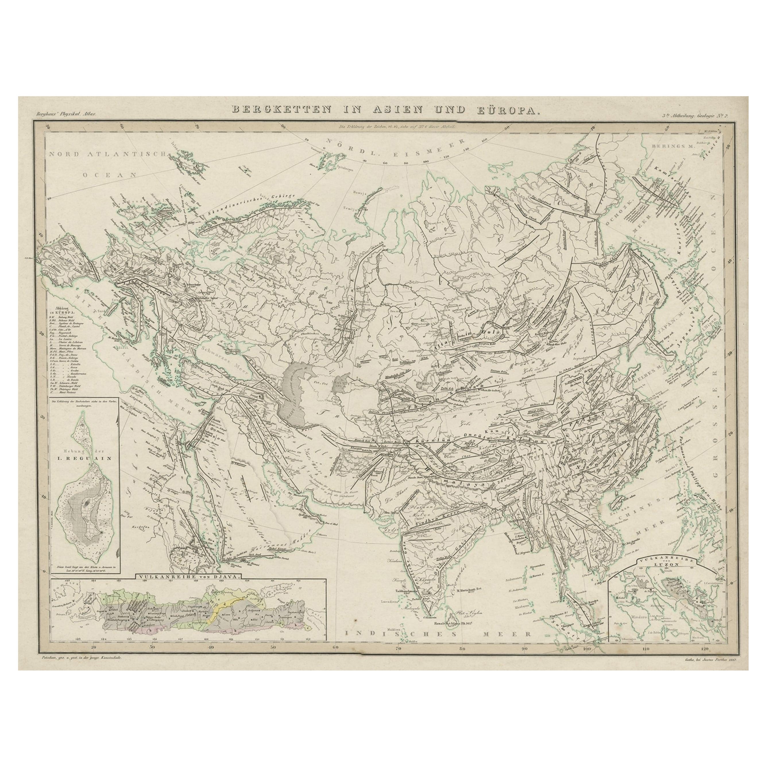
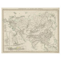
View AllOriginal Antique Map Showing the Mountain Ranges in Asia and Europe, 1849
Located in Langweer, NL
Antique map titled 'Bergketten in Asien und Eüropa'. Original antique map showing the mountain ranges in Asia and Europe. In outline color with inset maps of Java, Luzon, and Reguain...
Category
Antique 1840s Maps
Materials
Paper
$267 Sale Price
20% Off
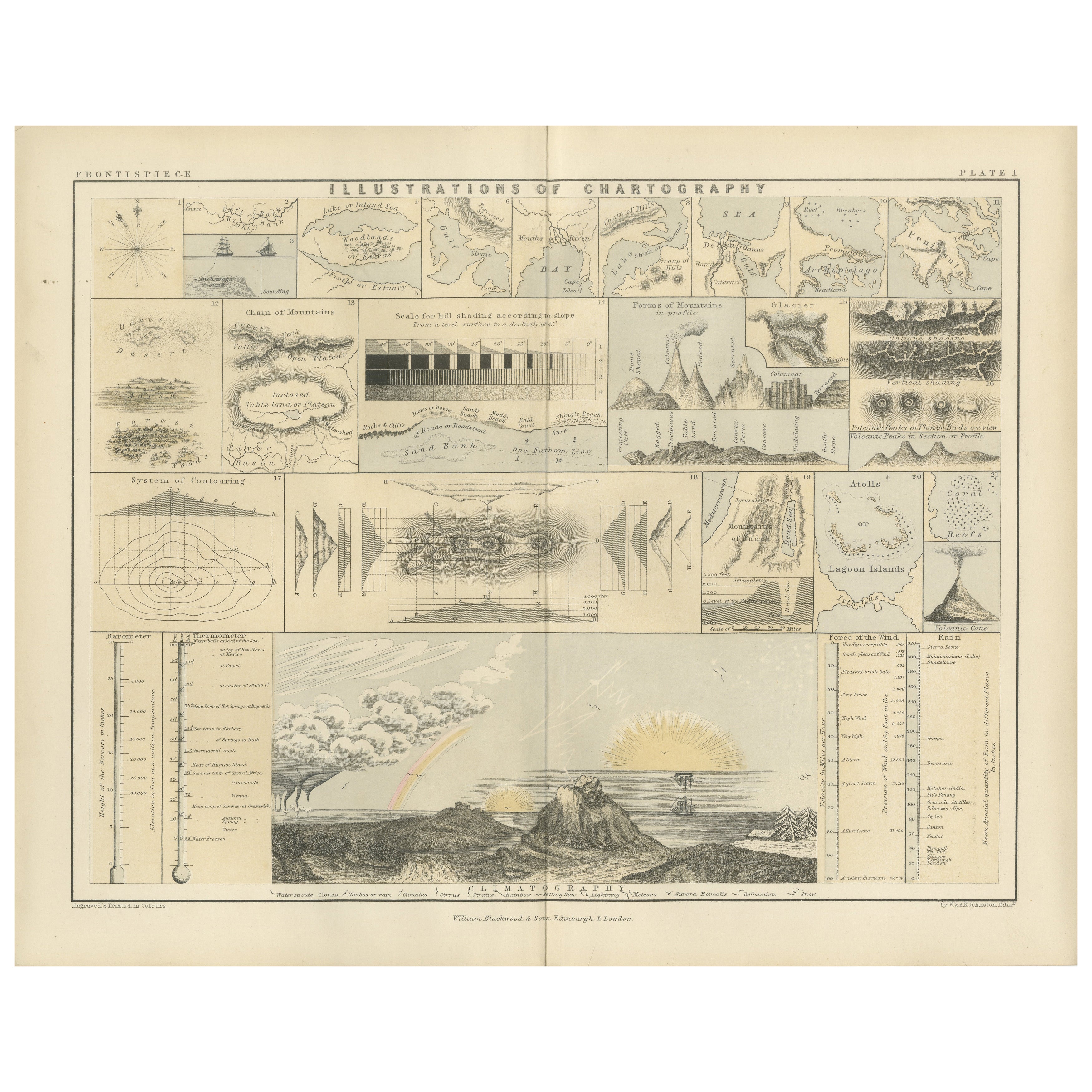
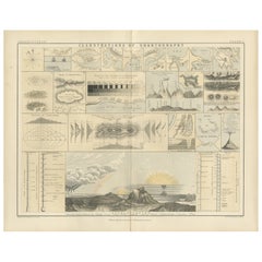
Cartography Print 1852 – Educational Diagram of Mountains, Winds, and Reefs
Located in Langweer, NL
Cartographic Masterpiece 1852 – Illustrated Guide to Map Symbols and Climate
Description:
This original 1852 plate titled "Illustrations of Chartography Plate I" offers a fascinating and visually rich introduction to 19th-century mapping techniques. Published in A School Atlas of Physical Geography by the eminent Scottish cartographer Alexander Keith Johnston, the plate served as an educational tool designed to teach the principles of cartography, climatology, geology, and meteorology.
The detailed engravings include symbolic representations used on maps, such as forms of mountains, volcanoes, reef systems, and rainfall diagrams, along with charts of wind directions, cloud formations, and the system of contouring. Particularly notable is the lower section titled "Climatography," which combines scientific elements into a picturesque landscape featuring a rainbow, tornado, sea spray, and a mountain chain—all stylized to represent the natural forces shaping Earth’s surface.
Johnston was a leading cartographer of the Victorian period, and this atlas was used widely in schools and scientific circles for its clarity and innovative visual methods. The plate was engraved and printed by W. & A.K. Johnston, his family firm, which gained a global reputation for excellence in educational publishing.
This chart is not only historically significant but also aesthetically appealing, making it an ideal piece for collectors of antique scientific prints...
Category
Antique Mid-19th Century Prints
Materials
Paper
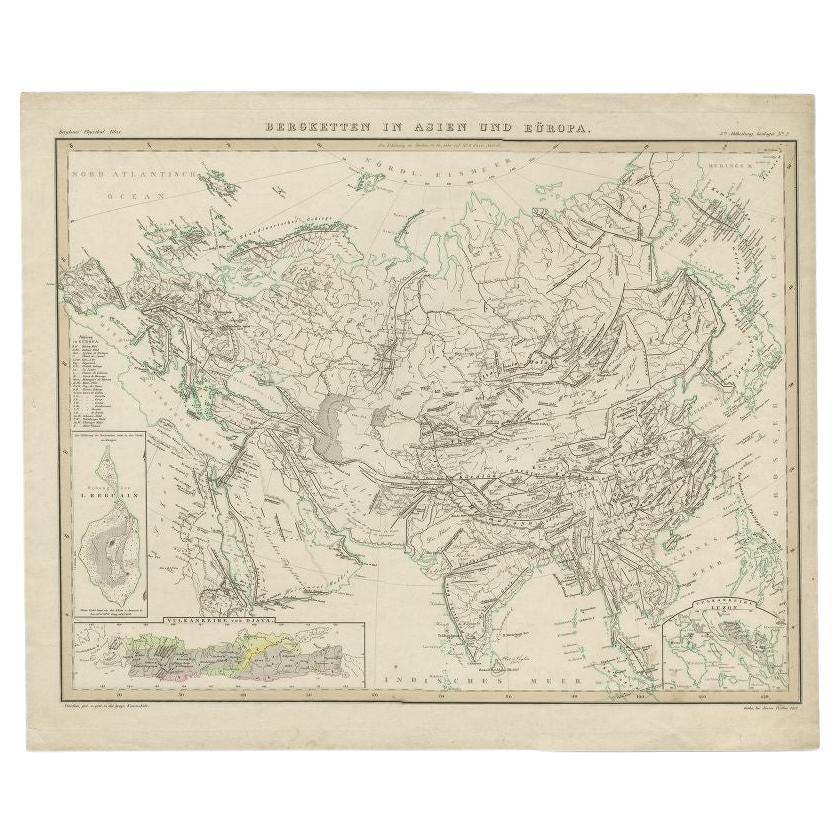
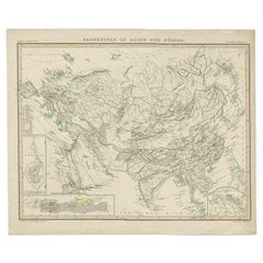
Antique Map of the Mountain Ranges of Asia and Europe by Berghaus, 1849
Located in Langweer, NL
Antique map titled 'Bergketten in Asien und Eüropa'. Original antique map showing the mountain ranges in Asia and Europe. In outline color with inset maps of Java, Luzon, and Reguain...
Category
Antique 19th Century Maps
Materials
Paper
$267 Sale Price
20% Off
Antique Detailed Map of the Mountain Chains of Europe and Asia, c.1850
Located in Langweer, NL
Antique map titled 'The Mountain Chains of Europe & Asia'.
Old map depicting the mountain chains of Europe and Asia. Originates from 'The Physical Atlas of Natural Phenomena'.
Ar...
Category
Antique 19th Century Maps
Materials
Paper

Antique Map of the Mountain Chains of Europe and Asia by Johnston '1850'
Located in Langweer, NL
Antique map titled 'The Mountain chains of the Europe and Asia '. Original antique map of the mountain chains of Europe and Asia. This map originates from 'The Physical Atlas of Natu...
Category
Antique Mid-19th Century Maps
Materials
Paper

$190 Sale Price
20% Off
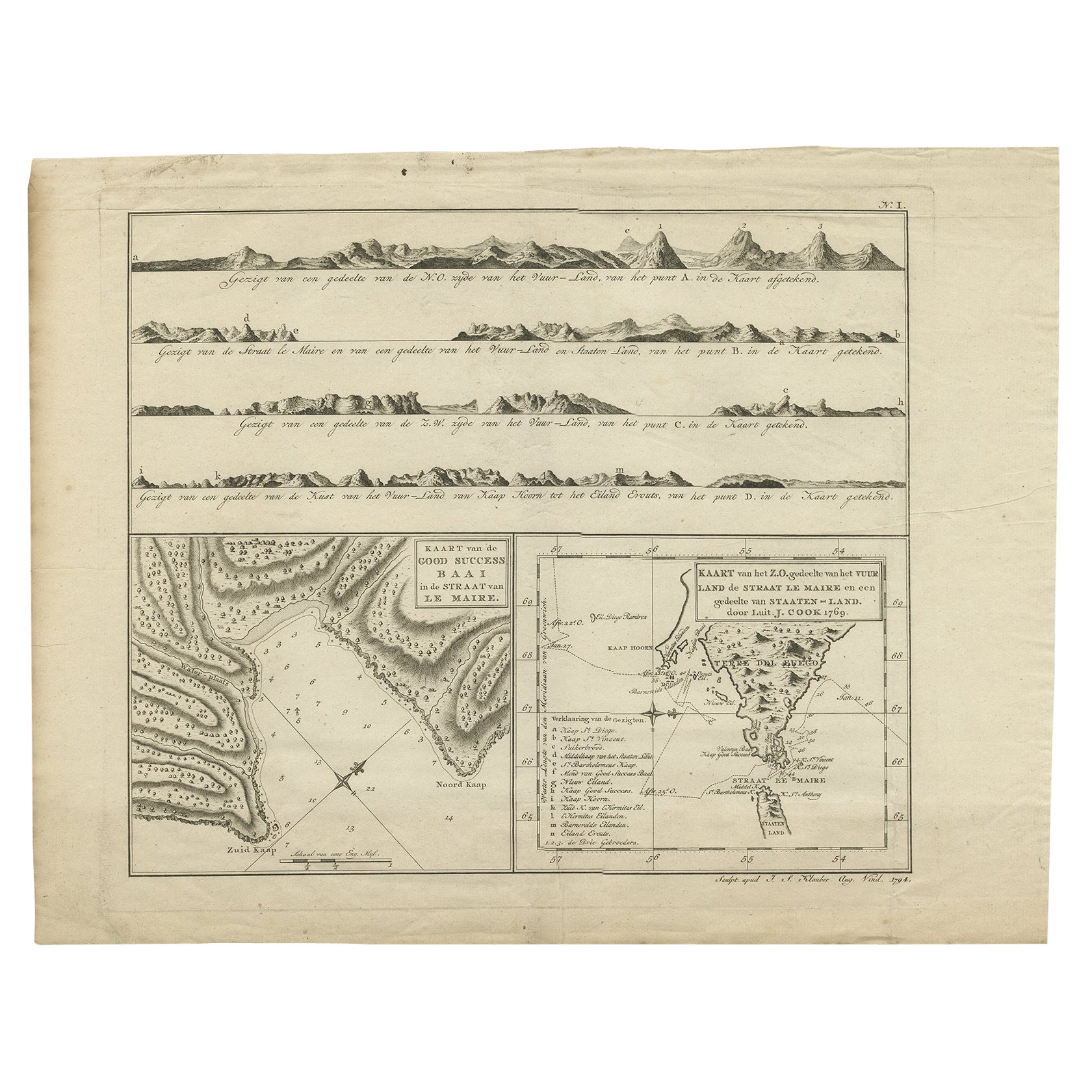
Antique Map of the Strait of Le Maire by Cook, 1803
Located in Langweer, NL
Antique map titled 'Kaart van de Good Success Baai in de Straat van Le Maire (..)'. Antique map of the Strait of Le Maire between Terra Fuego and Staten Island. On top, various coast...
Category
Antique 19th Century Maps
Materials
Paper

$600 Sale Price
20% Off
You May Also Like
Hautes Alpes, France. Antique map of a French department, 1856
By Victor Levasseur
Located in Melbourne, Victoria
'Dept. des Hautes Alpes', steel engraving with original outline hand-colouring., 1856, from Levasseur's 'Atlas National Illustre'.
This area of France i...
Category
19th Century Naturalistic Landscape Prints
Materials
Engraving

1839 Map of Karte Des "Russischen Reiches in Europa Und Asien" Ric.R0013
Located in Norton, MA
1839 map of Karte Des
"Russischen Reiches in Europa and Asien"
Ric.r013
Map of the European and Asian parts of Russian Empire. Karte der Russischen Reiches in Europa und Asien...
Category
Antique 19th Century Unknown Maps
Materials
Paper

Pyrenees Orientales, France. Antique map of a French department, 1856
By Victor Levasseur
Located in Melbourne, Victoria
'Dept. des Pyrenees Orientales', steel engraving with original outline hand-colouring., 1856, from Levasseur's 'Atlas National Illustre'.
This area is well-known wine producing reg...
Category
19th Century Naturalistic Landscape Prints
Materials
Engraving

Fine French Antique 1856 Hand Watercolour Map of Dept Des Hautes Pyrenees
Located in West Sussex, Pulborough
We are delighted to offer for sale this stunning 1856 hand watercolour map of the Austrian Alps titled Dept Des Hautes Pyrenees taken from the Atlas Nat...
Category
Antique 1850s French Early Victorian Maps
Materials
Paper

Hautes Pyrenees, France. Antique map of a French department, 1856
By Victor Levasseur
Located in Melbourne, Victoria
'Dept. des Hautes Pyrenees', steel engraving with original outline hand-colouring., 1856, from Levasseur's Atlas National Illustre.
This area is home to the wine producing region, ...
Category
19th Century Naturalistic Landscape Prints
Materials
Engraving
Fine Antique 1856 Hand Watercolour Map of Dept Des Hautes Alpes by Levasseur's
Located in West Sussex, Pulborough
We are delighted to offer for sale this stunning 1856 hand watercolour map of the Austrian Alps titled Dept Des Hautes Alpes taken from the Atlas National...
Category
Antique 1850s French Early Victorian Maps
Materials
Paper

More Ways To Browse
Wood Minimalist Chair
Antique Imperial Furniture
Gold Modern Coffee Table
Large Side Tables
18th Century Gilded Furniture
Japanese Silver Ceramics
One Of A Kind Chair
Used Oak Dining Room Chairs
17th Century Plate
Childrens Vintage Poster
Chinese Ship
Nursery Art
Vintage Travel Poster Mid Century
Desk Key
Woven Silk Art
Carved Cabriole Table
Dark Antique Table
White Wooden Table